|
Shaistaganj Junction Railway Station
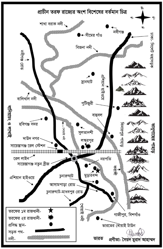
Shaistaganj Junction railway station is a junction station situated in Shayestaganj Upazila of Habiganj District in Bangladesh. It was opened in 1903 on Akhaura–Kulaura–Chhatak line. Then it became a junction station when Habiganj Bazar–Shaistaganj–Balla line railway was opened in 1928–29. But later in 2003, that line was abandoned as is closed in an unannounced manner and in 2005, the Habiganj Bazar–Shaistaganj line was taken off. Railroad Habiganj Bazar–Shaistaganj–Balla line During the colonial British rule, train services were started by rail at Habiganj Mahukuma in Sylhet district of the then (Undivided British-India) Assam province. In 1928, the British government built the Habiganj Bazar-Shaistaganj-Balla line as railway line and built infrastructure. The railway line was opened by the Assam Bengal Railway by the then British government from Habiganj district headquarters town to Balla border via Shaistaganj junction, about 45 or 52 kilometers long rail ... [...More Info...] [...Related Items...] OR: [Wikipedia] [Google] [Baidu] |
Junction Station
''Junction station'' usually refers to a railway station situated on or close to a junction where lines to several destinations diverge. The usual minimum is three incoming lines. At a station with platforms running from left to right, the minimum to qualify as a junction station would usually be one line on the left and two on the right (or vice versa). This is not to be confused with a station where there is one through line, but single track on one side while double track on the other. In this case, all trains passing through the station can reach only one destination as their next station. Commonly, junction stations have multiple platform faces to enable trains for multiple destinations to stand at the station at the same time, but this is not necessary. There are many stations with the word 'junction' in their title, such as those below: In Australia * Bondi Junction railway station *Eagle Junction railway station In Canada *Hervey-Jonction railway station *Sudbury Juncti ... [...More Info...] [...Related Items...] OR: [Wikipedia] [Google] [Baidu] |
Bengal
Bengal ( ; bn, বাংলা/বঙ্গ, translit=Bānglā/Bôngô, ) is a geopolitical, cultural and historical region in South Asia, specifically in the eastern part of the Indian subcontinent at the apex of the Bay of Bengal, predominantly covering present-day Bangladesh and the Indian state of West Bengal. Geographically, it consists of the Ganges-Brahmaputra delta system, the largest river delta in the world and a section of the Himalayas up to Nepal and Bhutan. Dense woodlands, including hilly rainforests, cover Bengal's northern and eastern areas, while an elevated forested plateau covers its central area; the highest point is at Sandakphu. In the littoral southwest are the Sundarbans, the world's largest mangrove forest. The region has a monsoon climate, which the Bengali calendar divides into six seasons. Bengal, then known as Gangaridai, was a leading power in ancient South Asia, with extensive trade networks forming connections to as far away as Roman Egypt. ... [...More Info...] [...Related Items...] OR: [Wikipedia] [Google] [Baidu] |
Habiganj District
Habiganj ( bn, হবিগঞ্জ, Hobigonj), formerly known as Habibganj ( bn, হবিবগঞ্জ, Hobibgonj), is a district in north-eastern Bangladesh, located in the Sylhet Division. It was established as a district in 1984 as a successor to its ''subdivision'' status since 1867. It is named after its headquarters, the town of Habiganj. History Ancient Prehistoric settlements were said to have been discovered in the Chaklapunji tea garden, near Chandirmazar of Chunarughat. Habiganj has also revealed a significant number of prehistoric tools from the bed of Balu Stream, a small ephemeral stream (water remains here only for a few hours after rainfall). Angularity and freshness of the fossil wood artifacts suggest that they did not come from a great distance and probably came from nearby hillocks. Typologically, technologically, and morphometrically, the artifacts are more or less the same as those found in the Lalmai, Comilla. The fossil wood assemblages of both of ... [...More Info...] [...Related Items...] OR: [Wikipedia] [Google] [Baidu] |
Railway Stations Opened In 1903
Rail transport (also known as train transport) is a means of transport that transfers passengers and goods on wheeled vehicles running on rails, which are incorporated in tracks. In contrast to road transport, where the vehicles run on a prepared flat surface, rail vehicles (rolling stock) are directionally guided by the tracks on which they run. Tracks usually consist of steel rails, installed on sleepers (ties) set in ballast, on which the rolling stock, usually fitted with metal wheels, moves. Other variations are also possible, such as "slab track", in which the rails are fastened to a concrete foundation resting on a prepared subsurface. Rolling stock in a rail transport system generally encounters lower frictional resistance than rubber-tyred road vehicles, so passenger and freight cars (carriages and wagons) can be coupled into longer trains. The operation is carried out by a railway company, providing transport between train stations or freight customer faciliti ... [...More Info...] [...Related Items...] OR: [Wikipedia] [Google] [Baidu] |
Mahisasan
Mahisasan is a border railway station and a defunct railway transit facility point on the India–Bangladesh border in Karimganj district in the Indian state of Assam. The corresponding station on the Bangladesh side is Shahbajpur (also known as Latu) in Sylhet District. The border station is linked to Karimganj away. The Mahisasan–Shahbajpur route has not been operational since December, 1996 due to lack of traffic. History In response to the demand of the Assam tea planters for a railway link to Chittagong port, Assam Bengal Railway started construction of a railway track on the eastern side of Bengal in 1891. A track between Chittagong and Comilla was opened to traffic in 1895. The Comilla–Akhaura–Kulaura–Badarpur section was opened in 1896–1898 and finally extended to in 1903. Mahisasan was a station on this track. With the partition of India in 1947, it assumed importance as a border station. Broad gauge The Railway Budget for 2011–12 has approved the conv ... [...More Info...] [...Related Items...] OR: [Wikipedia] [Google] [Baidu] |
Asiatic Society Of Bangladesh
The Asiatic Society of Bangladesh is a non political and non profit research organisation registered under both Society Act of 1864 and NGO Bureau, Government of Bangladesh. The Asiatic Society of Bangladesh was established as the Asiatic Society of East Pakistan in Dhaka in 1952 by a number of Muslim leaders, and renamed in 1972. Ahmed Hasan Dani, a noted Muslim historian and archaeologist of Pakistan played an important role in founding this society. He was assisted by Muhammad Shahidullah, a Bengali linguist. The society is housed in Nimtali, walking distance from the Curzon Hall of Dhaka University, locality of Old Dhaka. Publications The society's publications include: * ''Banglapedia, the National Encyclopedia of Bangladesh'' (edition 2, 2012) * ''Encyclopedia of Flora and Fauna of Bangladesh'' (2010, 28 volumes) * ''Cultural Survey of Bangladesh, a documentation of the country's cultural history, tradition and heritage'' (2008, 12 volumes) * ''Children’s Banglapedia'', a ... [...More Info...] [...Related Items...] OR: [Wikipedia] [Google] [Baidu] |
Lumding
Lumding (Pron:/lʌmˈdɪŋ/) is a city with municipal board in Hojai district in the Indian state of Assam. Etymology The word 'Lumding' owes its roots to a couple of Dimasa words 'Lama' and 'Ding' connoting 'straight pathway'. The word ''Lumding'' is also believed to be from karbi words 'loom' means the 'water from cloud' and 'ding' meaning 'scarcity or Nil'. There's another Railway station adjacent to it with the same root word "Lama" (Path), it is Lamasakhong (Valley of the small pathways) which is just a few kilometers away from Lumding. History Over the years Lumding has developed into township. The railway township had always enjoyed scant rainfall during the rainy season every year, although the trend has significantly altered over the past few decades. Lumding was also used as a radar station during World War II by the British. Transport Railway Lumding railway division is famous for being the biggest divisional headquarters of the Northeast Frontier Railway and ... [...More Info...] [...Related Items...] OR: [Wikipedia] [Google] [Baidu] |
Comilla
Comilla (; bn, কুমিল্লা, Kumillā, ), officially spelled Cumilla, is the fifth largest city of Bangladesh and second largest in Chittagong division. It is the administrative centre of the Comilla District. The name Comilla was derived from ''Komolangko'' (কমলাঙ্ক), meaning the pond of lotus. History Ancient era The Comilla region was once under ancient Samatata and was joined with Tripura State. This district came under the reign of the kings of the Harikela in the ninth century AD. Lalmai Mainamati was ruled by the Deva dynasty (eighth century AD), and (during the 10th and mid-11th century AD). In 1732, it became the centre of the Bengal-backed domain of Jagat Manikya. The Peasants' Movement against the king of Tripura in 1764, which originally formed under the leadership of Shamsher Gazi is a notable historical event in Comilla. It came under the rule of East India Company in 1765. This district was established as the Tripura district in 179 ... [...More Info...] [...Related Items...] OR: [Wikipedia] [Google] [Baidu] |
Chittagong
Chittagong ( /ˈtʃɪt əˌɡɒŋ/ ''chit-uh-gong''; ctg, চিটাং; bn, চিটাগং), officially Chattogram ( bn, চট্টগ্রাম), is the second-largest city in Bangladesh after Dhaka and third largest city in Bengal region. It is the administrative seat of the eponymous division and district. It hosts the busiest seaport on the Bay of Bengal. The city is located on the banks of the Karnaphuli River between the Chittagong Hill Tracts and the Bay of Bengal. The Greater Chittagong Area had a population of more than 5.2 million in 2022. In 2020, the city area had a population of more than 3.9 million. One of the world's oldest ports with a functional natural harbor for centuries, Chittagong appeared on ancient Greek and Roman maps, including on Ptolemy's world map. It was located on the southern branch of the Silk Road. In the 9th century, merchants from the Abbasid Caliphate established a trading post in Chittagong. The port fell to the Muslim co ... [...More Info...] [...Related Items...] OR: [Wikipedia] [Google] [Baidu] |
Port Of Chittagong
The Chittagong Port ( bn, চট্টগ্রাম বন্দর) is the main seaport of Bangladesh. Located in Bangladesh's port city of Chittagong and on the banks of the Karnaphuli River, the port handles over 90 percent of Bangladesh's export-import trade, and has been used by India, Nepal and Bhutan for transshipment. According to Lloyd's, it ranked as the 58th busiest container port in the world in 2019. The port is one of the oldest in the world, with a recorded history dating back to ancient Roman accounts. It is the busiest container port on the Bay of Bengal. Congestion is a major challenge in Chittagong port. The port had a congestion rate of 84.3 hours between January and July in 2017. History The Chittagong area has been a recorded seaport since the 4th century BCE. In the 2nd century, the harbor appeared on Ptolemy's map, drawn by the Greco-Roman cartographer Claudius Ptolemy. The map mentions the harbor as one of the finest in the Eastern world. The ''Perip ... [...More Info...] [...Related Items...] OR: [Wikipedia] [Google] [Baidu] |
Shayestaganj Upazila
Shayestaganj ( bn, শায়েস্তাগঞ্জ), also spelt Shaistaganj, is an upazila (sub-district) of Habiganj District in northeastern Bangladesh, part of the Sylhet Division. There is one Paurasava (Municipality) and three Unions under this Thana. They are: Shaistaganj Paurasava, Shaistaganj Union, Nurpur Union and Brammondura Union. Shaistaganj Railway Junction, Hospital, Market, Township, other offices and important places are located here since long. Initially Nizampur and Laskarpur Unions of Habiganj Sadar Upazila were also part of Shayestaganj. Ubahata Union of Chunarughat Upazila and Baghasura Union of Madhabpur Upazila are to be part of it. History According to Achyut Charan Choudhury, a ''bazaar'' and courthouse was established approximately 300 years ago on the banks of the Khowai River by Syed Shayesta Miah as Shayesta Miah's Bazar and named after himself. The old market of modern-day Shayestaganj is viewed as the original Shayesta Miah's Bazar which e ... [...More Info...] [...Related Items...] OR: [Wikipedia] [Google] [Baidu] |


