|
Serayu River
The Serayu River is a river in Central Java, Indonesia, about 300 km southeast of the capital Jakarta. Hydrology The river spanned from northeast to southwest with length around 181 km, and crossring five ''kabupaten'' (regency) in Central Java; they are Wonosobo Regency, Banjarnegara Regency, Purbalingga Regency, Banyumas Regency, draining to Indian Ocean with estuarine located at Cilacap Regency. 2009Karakteristik daerah aliran sungai (DAS) Serayu Provinsi Jawa Tengah berdasarkan kondisi fisik, sosial, serta ekonomi.Dept. Geografi FMIPA Universitas Indonesia. (paper tidak diterbitkan) Geography The river flows in the southern central area of Java with predominantly tropical monsoon climate (designated as ''Am'' in the Köppen-Geiger climate classification). The annual average temperature in the area is 24 °C. The warmest month is March, when the average temperature is around 25 °C, and the coldest is August, at 23 °C. The average annual rainfall is 3897& ... [...More Info...] [...Related Items...] OR: [Wikipedia] [Google] [Baidu] |
Dieng Volcanic Complex
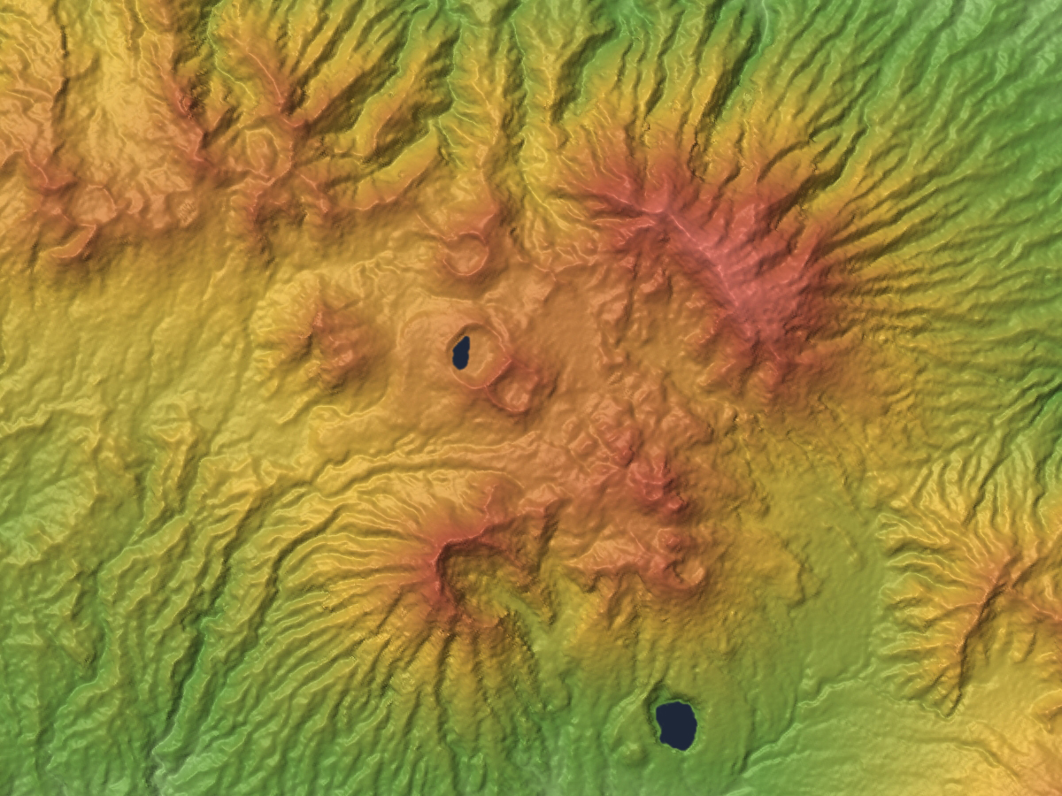
The Dieng Volcanic Complex ( jv, ꦢꦶꦲꦾꦁ, Dihyang) is a volcanic complex located on the Dieng Plateau in the Central Java, Indonesia, a complex of volcanoes. The volcanic complex consists of two or more of stratovolcanoes, more than 20 small craters and Pleistocene-to-Holocene age volcanic cones. It covers over 6 × 14 km area. The Prahu stratovolcano was truncated by a large Pleistocene caldera and then filled by parasitic cones, lava domes and craters which is 120 Celsius. Some of them are turned into lakes. Toxic volcanic gas has caused fatalities and is a hazard at several craters. On 20 February 1979 149 people died of gas poisoning in Pekisaran village on the plateau near the Sinila crater. ''The Jakarta Post'' The area is also home ... [...More Info...] [...Related Items...] OR: [Wikipedia] [Google] [Baidu] |
Cilacap Regency
Cilacap Regency ( jv, ꦏꦨꦸꦥꦠꦺꦤ꧀ꦕꦶꦭꦕꦥ꧀, also spelt: Chilachap, old spelling: Tjilatjap, Sundanese: ) is a regency () in the southwestern part of Central Java province in Indonesia. Its capital is the town of Cilacap. Cilacap Regency covers an area of 2,252.50 km2 (including the 115-km2 Nusakambangan Island off the south coast), and it had a population of 1,642,107 at the 2010 Census and 1,944,857 at the 2020 Census; the official estimate as at mid 2021 was 1,963,824. The languages used in Cilacap are the Javanese language and Sundanese language, but most people can speak Indonesian. The dialect used is Banyumasan. There are schools of all levels in Cilacap and several higher-learning institutions. There are several academies such as Akademi Maritim Nusantara (National Maritime Academy). A polytechnic, called Politeknik Cilacap, was established in 2008 and offers education in Engineering, Electronics and Informatics. Administrative Districts Cil ... [...More Info...] [...Related Items...] OR: [Wikipedia] [Google] [Baidu] |
List Of Rivers Of Java
List of rivers flowing in the island of Java, Indonesia.''Map of Indonesia''. Peta Indonesia. Wawasan Nusantara. CV. Indo Prima Sarana. Accessed 29 Juli 2017. In alphabetical order Mouth location The following list groups the rivers by the direction of the flow: the west, north, south or east coast of the Java island. West coast of Java The following river flows toward the west coast of Java to the Sunda Strait. * Liman River North coast of Java The following rivers flow toward the north coast of Java to the Java Sea (from west to east). North coast of Jakarta The following rivers flow toward the north coast of Jakarta to the Java Sea (from west to east). South coast of Java The following rivers flow toward the south coast of Java to the Indian Ocean. East coast of Java The following river flows toward the east coast of Java to the Bali Strait. * Setail River By Province Banten Central Java East Java Jakarta West Java Yogyakarta See also * List of rivers of ... [...More Info...] [...Related Items...] OR: [Wikipedia] [Google] [Baidu] |
List Of Rivers Of Indonesia
This is a list of rivers in Indonesia.''Map of Indonesia''. Peta Indonesia. Wawasan Nusantara. CV. Indo Prima Sarana. Accessed 29 Juli 2017. By island This list is arranged by island in alphabetical order, with respective tributaries indented under each larger stream's name. Ambon * Sikula Bali Buru * Waeapo Flores Java Kalimantan : ''Below are the rivers in the Indonesian territory of Borneo (Kalimantan)'' Papua Seram Sulawesi * ''Tamborasi River'' Sumatra Sumba Sumbawa West Timor West Timor ( id, Timor Barat) is an area covering the western part of the island of Timor, except for the district of Oecussi-Ambeno (an East Timorese exclave). Administratively, West Timor is part of East Nusa Tenggara Province, Indonesia. The ca ... By province Notes and references Sources *Rand McNally, ''The New International Atlas'', 1993. GEOnet Names Server [...More Info...] [...Related Items...] OR: [Wikipedia] [Google] [Baidu] |
Sunda Kingdom
The Sunda Kingdom ( su, , Karajaan Sunda, ) was a Sundanese Hindu kingdom located in the western portion of the island of Java from 669 to around 1579, covering the area of present-day Banten, Jakarta, West Java, and the western part of Central Java. The capital of the Sunda Kingdom moved several times during its history, shifting between the Galuh (Kawali) area in the east and Pakuan Pajajaran in the west. The Sunda Kingdom reached its peak during the reign of King Sri Baduga Maharaja, whose reign from 1482 to 1521 is traditionally remembered as an age of peace and prosperity among Sundanese people. According to primary historical records such as the Bujangga Manik manuscript, the eastern border of the kingdom was the Pamali River (Ci Pamali, the present-day Brebes River) and the Serayu River (Ci Sarayu) in Central Java. Most accounts of the Sunda Kingdom come from primary historical records from the 16th century. The kingdom's inhabitants were primarily the eponymous ethni ... [...More Info...] [...Related Items...] OR: [Wikipedia] [Google] [Baidu] |
Ramayana
The ''Rāmāyana'' (; sa, रामायणम्, ) is a Sanskrit literature, Sanskrit Indian epic poetry, epic composed over a period of nearly a millennium, with scholars' estimates for the earliest stage of the text ranging from the 8th to 4th centuries BCE, and later stages extending up to the 3rd century CE. ''Ramayana'' is one of the two important epics of Hinduism, the other being the ''Mahabharata, Mahābhārata''. The epic, traditionally ascribed to the Maharishi Valmiki, narrates the life of Sita, the Princess of Janakpur, and Rama, a legendary prince of Ayodhya city in the kingdom of Kosala. The epic follows his fourteen-year exile to the forest urged by his father King Dasharatha, on the request of Rama's stepmother Kaikeyi; his travels across forests in the South Asia, Indian subcontinent with his wife Sita and brother Lakshmana, the kidnapping of Sita by Ravana – the king of Lanka, that resulted in war; and Rama's eventual return to Ayodhya to be crowned kin ... [...More Info...] [...Related Items...] OR: [Wikipedia] [Google] [Baidu] |
Sarayu
The Sarayu is a river that originates at a ridge south of Nanda Kot mountain in Bageshwar district in Uttarakhand, India. It flows through Kapkot, Bageshwar, and Seraghat towns before discharging into the Sharda River at Pancheshwar at the India—Nepal border. Sharda river (also known as Kali river) then flows into Ghaghara river in Sitapur District, Uttar Pradesh, India. Lower Ghaghara is also popularly known as Sarayu in India. Especially while it flows through the city of Ayodhya, the birth place of the Hindu deity Rama. The river is mentioned various times in the ancient Indian epic of Ramayana. Course The Sarayu rises at Sarmul (or Sarmool), which is located in the extreme north of the district Bageshwar of Uttarakhand on the southern slope of a ridge of the Nanda Kot. It flows through the Kumaon Himalayas, passes by the towns of Kapkot, Bageshwar and Seraghat before flowing into the Sharda River at Pancheshwar. Etymology The name is the feminine derivative of the ... [...More Info...] [...Related Items...] OR: [Wikipedia] [Google] [Baidu] |
Hydroelectricity
Hydroelectricity, or hydroelectric power, is Electricity generation, electricity generated from hydropower (water power). Hydropower supplies one sixth of the world's electricity, almost 4500 TWh in 2020, which is more than all other Renewable energy, renewable sources combined and also more than nuclear power. Hydropower can provide large amounts of Low-carbon power, low-carbon electricity on demand, making it a key element for creating secure and clean electricity supply systems. A hydroelectric power station that has a dam and reservoir is a flexible source, since the amount of electricity produced can be increased or decreased in seconds or minutes in response to varying electricity demand. Once a hydroelectric complex is constructed, it produces no direct waste, and almost always emits considerably less greenhouse gas than fossil fuel-powered energy plants. [...More Info...] [...Related Items...] OR: [Wikipedia] [Google] [Baidu] |
Tropical Monsoon Climate
An area of tropical monsoon climate (occasionally known as a sub-equatorial, tropical wet climate or a tropical monsoon and trade-wind littoral climate) is a tropical climate sub-type that corresponds to the Köppen climate classification category ''Am''. Tropical monsoon climates have monthly mean temperatures above in every month of the year and a dry season. The tropical monsoon climate is the intermediate climate between the wet Af (or tropical rainforest climate) and the drier Aw (or tropical savanna climate). A tropical monsoon climate's driest month has on average less than 60 mm, but more than 100-\left(\frac\right). This is in direct contrast to a tropical savanna climate, whose driest month has less than 60 mm of precipitation and also less than 100-\left(\frac\right) of average monthly precipitation. In essence, a tropical monsoon climate tends to either have more rainfall than a tropical savanna climate or have less pronounced dry seasons. A tropical monsoon c ... [...More Info...] [...Related Items...] OR: [Wikipedia] [Google] [Baidu] |
Banyumas Regency
Banyumas ( jv, ꦧꦚꦸꦩꦱ꧀, formerly spelt "Banjoemas") Regency is a regency ( id, kabupaten) in the southwestern part of Central Java province in Indonesia. Its capital is the town of Purwokerto, but that town no longer has a central administration and is split over four of the districts within the Regency, with a combined population of 230,235 as at mid 2021. The Regency covers an area of 1,327.59 km2, and had a population of 1,554,527 at the 2010 Census and 1,776,918 at the 2020 Census; the official estimate of population as at mid 2021 was 1,789,630. The term ''Banyumasan'' is also used as an adjective referring to the culture, language and peoples of the wider Banyumas area, equivalent to the pre-independence Banyumas Residency. The language of Banyumasan is of Austronesian origin, and is usually considered to be a dialect of Javanese. Administrative districts Banyumas Regency comprises twenty-seven districts (''kecamatan''), tabulated below with their area ... [...More Info...] [...Related Items...] OR: [Wikipedia] [Google] [Baidu] |
Indian Ocean
The Indian Ocean is the third-largest of the world's five oceanic divisions, covering or ~19.8% of the water on Earth's surface. It is bounded by Asia to the north, Africa to the west and Australia to the east. To the south it is bounded by the Southern Ocean or Antarctica, depending on the definition in use. Along its core, the Indian Ocean has some large marginal or regional seas such as the Arabian Sea, Laccadive Sea, Bay of Bengal, and Andaman Sea. Etymology The Indian Ocean has been known by its present name since at least 1515 when the Latin form ''Oceanus Orientalis Indicus'' ("Indian Eastern Ocean") is attested, named after Indian subcontinent, India, which projects into it. It was earlier known as the ''Eastern Ocean'', a term that was still in use during the mid-18th century (see map), as opposed to the ''Western Ocean'' (Atlantic Ocean, Atlantic) before the Pacific Ocean, Pacific was surmised. Conversely, Ming treasure voyages, Chinese explorers in the Indian Oce ... [...More Info...] [...Related Items...] OR: [Wikipedia] [Google] [Baidu] |
Purbalingga Regency
Purbalingga Regency ( Javanese: ꦥꦸꦂꦧꦭꦶꦁꦒ) is an inland regency ( id, kabupaten) in the southwestern part of Central Java province in Indonesia. Purbalingga Regency has an area of 777.64 km2 and population of 848,952 at the 2010 census and 998,561 at the 2020 census, comprising 505,281 male and 493,280 female inhabitants; the official estimate as at mid 2021 was 1,007,794. The administrative capital is the town of Purbalingga. Etymology The term ''Purbalinga'' comes from the Sanskrit root words of Hindu origin, '' purba'' (east) and ''linga'' (an abstract representation of Hindu deity Lord ''Shiva''), thus meaning the ''Lord Shiva of East''. This reflects the historic origin of the place that the Srivijaya-era or earlier founders of the place had built a Hindu temple of the Lord Shiva here in whose honor the place was named by the founder ruling dynasty. History Purbalingga is steeped in the ancient history of the Hindu empires of the Srivijaya and Majapahi ... [...More Info...] [...Related Items...] OR: [Wikipedia] [Google] [Baidu] |


