|
Serampore
Serampore (also called ''Serampur'', ''Srirampur'', ''Srirampore'', ''Shreerampur'', ''Shreerampore'', ''Shrirampur'' or ''Shrirampore'') is a city of Hooghly district in the Indian state of West Bengal. It is the headquarter of the Srirampore subdivision. It is a part of the area covered by Kolkata Metropolitan Development Authority (KMDA) and Greater Kolkata. It is a pre-colonial city on the west bank of the Hooghly River. It was part of Danish India under the name ''Frederiknagore'' from 1755 to 1845. Geography Location Serampore is located at . The area consists of flat alluvial plains, that form a part of the Gangetic Delta. This belt is highly industrialised. Police stations Serampore police station has jurisdiction over Serampore and Baidyabati Municipal areas, and parts of Sreerampur Uttarpara CD Block. Serampore Women police station has been set up. Urbanisation Srirampore subdivision is the most urbanized of the subdivisions in Hooghly district. 73.13% of ... [...More Info...] [...Related Items...] OR: [Wikipedia] [Google] [Baidu] |
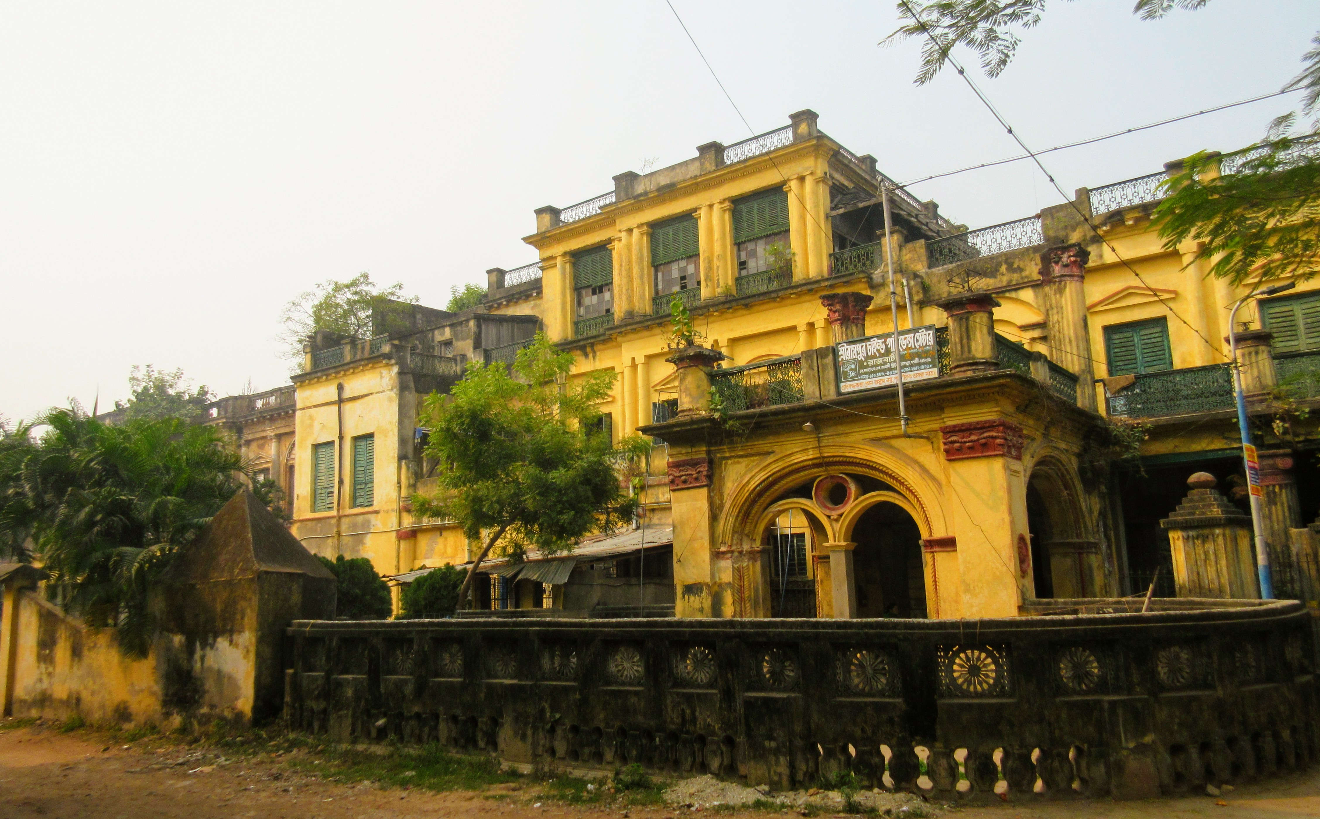
Serampore Raj Bari
Serampore (also called ''Serampur'', ''Srirampur'', ''Srirampore'', ''Shreerampur'', ''Shreerampore'', ''Shrirampur'' or ''Shrirampore'') is a city of Hooghly district in the Indian state of West Bengal. It is the headquarter of the Srirampore subdivision. It is a part of the area covered by Kolkata Metropolitan Development Authority (KMDA) and Kolkata metropolitan area, Greater Kolkata. It is a pre-colonial city on the west bank of the Hooghly River. It was part of Danish India under the name ''Frederiknagore'' from 1755 to 1845. Geography Location Serampore is located at . The area consists of flat alluvium, alluvial plains, that form a part of the Gangetic Delta. This belt is highly industrialised. Police stations Serampore police station has jurisdiction over Serampore and Baidyabati Municipal areas, and parts of Sreerampur Uttarpara CD Block. Serampore Women police station has been set up. Urbanisation Srirampore subdivision is the most urbanized of the subdivisions ... [...More Info...] [...Related Items...] OR: [Wikipedia] [Google] [Baidu] |
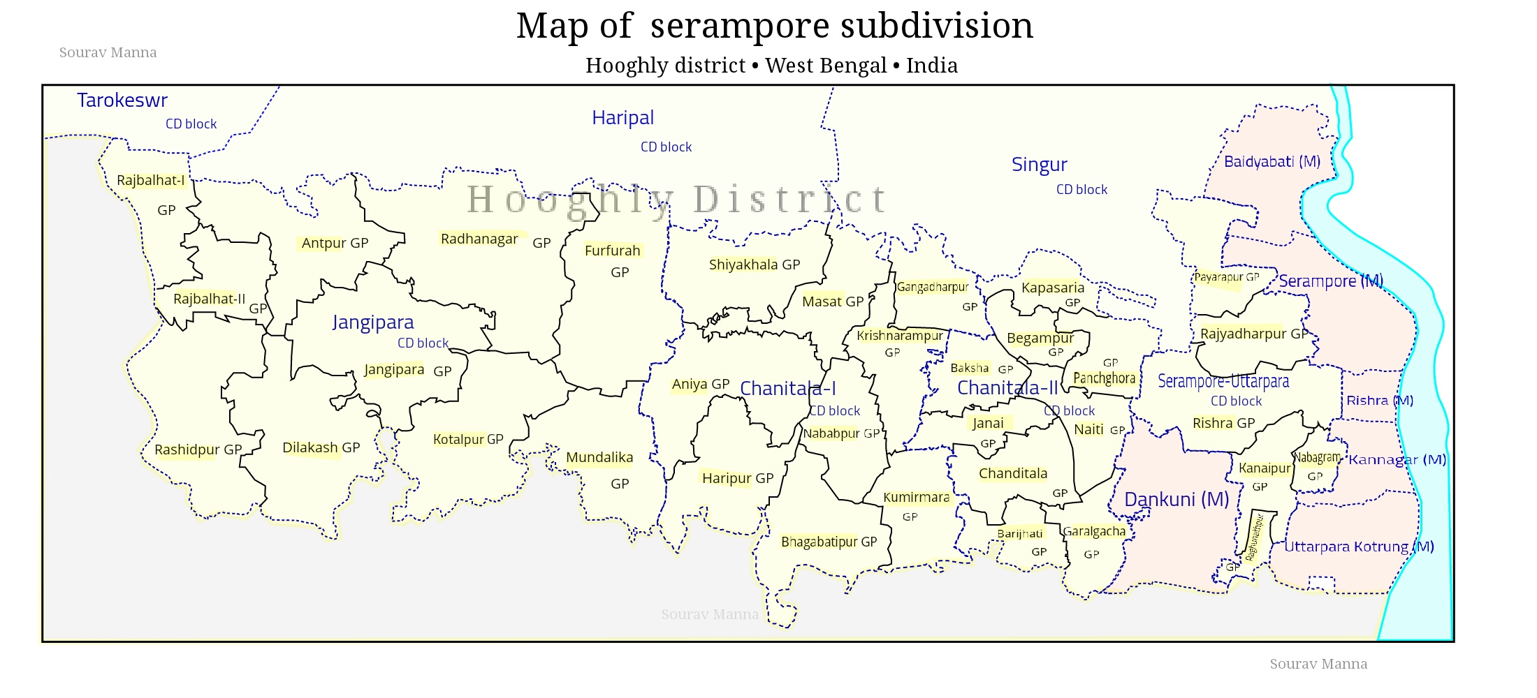
Srirampore Subdivision
Srirampore subdivision is an administrative subdivision of the Hooghly district in the state of West Bengal, India. Overview Srirampore subdivision is the most urbanised, and the one with the highest density of population, of all the subdivisions of Hooghly district. Urbanisation started with industrialisation of the Hooghly Flats, the narrow strip of land along the Hooghly and spread inland covering a large portion of Hooghly-Damodar Plain, the agriculturally rich alluvial plains lying between the Hooghly and the Damodar. The entire area is a part of the Gangetic Delta. The Hooghly is a tidal river and has a high west bank. The spread of urbanisation obviously affected the livelihood of the people, with a high proportion of workers being engaged in non-agricultural pursuits. Subdivisions The Hooghly district is divided into the following administrative subdivisions: Administrative units 400 px, right Srirampore subdivision has 7 police stations, 4 community developme ... [...More Info...] [...Related Items...] OR: [Wikipedia] [Google] [Baidu] |
Hooghly District
Hooghly district () is one of the districts of the Indian state of West Bengal. It can alternatively be spelt ''Hoogli'' or ''Hugli''. The district is named after the Hooghly River. The headquarters of the district are at Hooghly-Chinsura (''Chuchura''). There are four subdivisions: Chinsurah Sadar, Srirampore, Chandannagore, and Arambagh. History The district of Hooghly derived its name from the town of Hooghly on the west bank of the Hugli River about 40 km north of Kolkata. This town was a major river port for trade in India before colonialism. The district has thousands of years of rich heritage as part of the Bengali kingdom of Bhurshut. The first European to reach this area was the Portuguese sailor Vasco da Gama. In 1536 Portuguese traders obtained a permit from Sultan Mahmud Shah to trade in this area. In those days the Hooghly River was the main route for transportation and Hooghly served as an excellent trading port. Within a few decades, the town of Hoog ... [...More Info...] [...Related Items...] OR: [Wikipedia] [Google] [Baidu] |
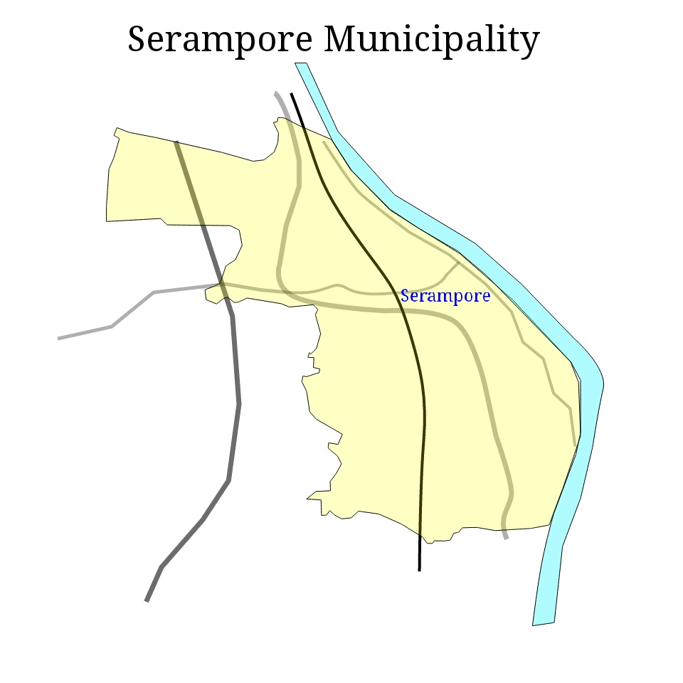
Serampore Municipality
Serampore Municipality is the civic body that governs Serampore and its surrounding areas (Mahesh, Serampore, Mahesh, Tin Bazar, Battala and partly Chatra, Serampore, Chatra) in Srirampore subdivision of Hooghly district, West Bengal, India. History Serampore is the first town in Bengal to voluntarily adopt the Municipal Act of 1850 Sec XX16. It is not clear when Serampore Municipality was established. Serampore is a pre-colonial town on the west bank of the Hooghly River, Hooghly. It was part of Danish India, under the name of Fredericksnagore, from 1755 to 1845. Geography Serampore Municipality covers an area of 17.60 km2 and has a total population of 183,339 (2011). In 1981, 29.44% of the total population formed main workers and 70.56% were non-workers in Serampore Municipality and 54.25% of the total main workers were industrial workers. This may be interpreted as follows: although industrial activities are prominent in the municipal areas of the region, the major portio ... [...More Info...] [...Related Items...] OR: [Wikipedia] [Google] [Baidu] |
Sreerampur (Vidhan Sabha Constituency)
Sreerampur Assembly constituency (previously called 180,Serampore and changed to 186,Sreerampur for the 2011 election onwards) is an Vidhan Sabha, assembly constituency in Hooghly district in the Indian States and territories of India, state of West Bengal. Overview As per orders of the Delimitation Commission, No. 186 Sreerampur Assembly constituency is composed of the following: Ward Nos. 3 to 19 and 25 of Serampore Municipality, Rishra Municipality, Rajyadharpur and Rishra gram panchayats of Sreerampur Uttarpara Community Development Block in India, community development block. Sreerampur Assembly constituency is part of No. 27 Srerampur (Lok Sabha constituency). Members of Legislative Assembly Election results 2021 In 2021 West Bengal Legislative Assembly election, 2021 West Bengal Assembly Election All India Trinamool Congress, All Indian Trinamool Congress candidate Sudipta Roy defeated his nearest rival Kabir Sankar Bose of Bharatiya Janata Party, Bharatiya Janta Party ... [...More Info...] [...Related Items...] OR: [Wikipedia] [Google] [Baidu] |
Srerampur (Lok Sabha Constituency)
Serampore (previously known as Serampore-26 and changed to Srerampur-27 in the 2009 election) is one of the 543 Lok Sabha (parliamentary) constituencies in India. The constituency centres on Serampore in West Bengal. Five assembly segments of the constituency are in Hooghly district and two are in Howrah district. Overview Srerampur is basically an industrial constituency with an agricultural hinterland. The Howrah-Hooghly industrial belt on the west bank of the Hooghly river covers the Howrah Lok Sabha constituency, Howrah, Hooghly Lok Sabha constituency, Hooghly and Srerampur constituency. According to ''The Hindu'', Serampore and Howrah constituencies have more than 25% non-Bengali voters with their roots in Rajasthan, Bihar or Uttar Pradesh. Vidhan Sabha segments As per order of the Delimitation Commission issued in 2006 in respect of the delimitation of constituencies in the West Bengal, parliamentary constituency no. 27 Sreerampur is composed of the following segments: ... [...More Info...] [...Related Items...] OR: [Wikipedia] [Google] [Baidu] |
Rishra
Rishra is a city and a municipality in Srirampore subdivision of Hooghly district in the Indian state of West Bengal. It is a part of the area covered by Kolkata Metropolitan Development Authority (KMDA). History The origin of Rishra situated on the right bank of the River Hugli dates back to the pre-colonial era. The reference of Rishra was first seen to have occurred in Bipradas Piplai's “Manasamangal Kavya”, written in the fifteenth century. At the time of giving a description of the movement of Chand Saudagar along the River Bhagirathi in a barge for the business. There has been further and marked an evolution in the said spelling down the era as Reshra, Risshra, Isharah, Ichera, Icchra, etc. In Jadavpur University, a research work was conducted in respect of the names of villages in our country. It was noticed that there are several villages in our country in a single name. But the name of Rishra has been found to be unique during such research exercise. In the book w ... [...More Info...] [...Related Items...] OR: [Wikipedia] [Google] [Baidu] |
Danish India
Danish India () was the name given to the colonies of Denmark (Denmark–Norway before 1814) in the Indian subcontinent, forming part of the Danish colonial empire. Denmark–Norway held colonial possessions in India for more than 200 years, including the town of Tharangambadi in present-day Tamil Nadu state, Serampore in present-day West Bengal, and the Nicobar Islands, currently part of India's union territory of the Andaman and Nicobar Islands. The Danish and Norwegian presence in India was of little significance to the major European powers as they presented neither a military nor a mercantile threat. Dano-Norwegian ventures in India, as elsewhere, were typically undercapitalised and never able to dominate or monopolise trade routes in the same way that British, French, and Portuguese ventures could. Despite these disadvantages, the Danish-Norway concerns managed to cling to their colonial holdings and, at times, to carve out a valuable niche in international trade by tak ... [...More Info...] [...Related Items...] OR: [Wikipedia] [Google] [Baidu] |
Rathayatra Of Mahesh
The Rathayatra of Mahesh ( bn, মাহেশের রথযাত্রা) is the second oldest chariot festival or Rath Yatra in India (after '' Rath Yatra of Puri'') and oldest in Bengal, having been celebrated since 1396. It is held in Mahesh, a historical locality within Serampore in the Indian state of West Bengal. It is a week-long festival and a grand fair is held at that time. ''indianexpress.com''. Retrieved 13 July 2021 People throng to have a share in pulling the long ropes (Rosshi) attached to the chariots of Lord |
Hooghly River
The Bhagirathi Hooghly River (Anglicized alternatively spelled ''Hoogli'' or ''Hugli'') or the 'Bhāgirathi-Hooghly', called the Ganga or the Kati-Ganga in mythological texts, is the eastern distributary of the Ganges River in West Bengal, India, rising close to Giria in Murshidabad. The main distributary of the Ganges then flows into Bangladesh as the Padma. Today there is a man-made canal called the Farakka Feeder Canal connecting the Ganges to the Bhagirathi. The river flows through the Rarh region, the lower deltaic districts of West Bengal, and eventually into the Bay of Bengal. The upper riparian zone of the river is called Bhagirathi while the lower riparian zone is called Hooghly. Major rivers that drain into the Bhagirathi-Hooghly include Mayurakshi, Jalangi , Ajay, Damodar, Rupnarayan and Haldi rivers other than the Ganges. Hugli-Chinsura, Bandel, Chandannagar, Srirampur, Barrackpur, Rishra, Uttarpara, Titagarh, Kamarhati, Agarpara, Baranagar and Kolkata are loc ... [...More Info...] [...Related Items...] OR: [Wikipedia] [Google] [Baidu] |
Kalyan Banerjee (politician)
Kalyan Banerjee (Bengali: কল্যাণ বন্দ্যোপাধ্যায়; born 4 January 1957) is a member of the All India Trinamool Congress. He has won the 2019 Indian general elections from the Serampore (Lok Sabha constituency) Serampore (previously known as Serampore-26 and changed to Srerampur-27 in the 2009 election) is one of the 543 Lok Sabha (parliamentary) constituencies in India. The constituency centres on Serampore in West Bengal. Five assembly segments of the .... He was earlier elected for the 16th Lok Sabha from the same constituency. Kalyan education qualification is B.Com. and LL.B. He is a well known advocate, who has been frequently taking up numerous cases for Trinamool Congress. He has been practicing in Calcutta High Court since 1981. Some of the cases he handled are of Rizwanur Rahman Case, matters relating to Nandigram, Chhota Angaria Case, Bhikari Paswan Case, Imposition of Sec-144 in Singur and different land acquisition cases ... [...More Info...] [...Related Items...] OR: [Wikipedia] [Google] [Baidu] |
Baidyabati
Baidyabati is a city and a municipality of Hooghly district in the State of West Bengal in India. It is under Serampore police station of Srirampore subdivision. It is a part of the area covered by Kolkata Metropolitan Development Authority (KMDA). Geography Location Baidyabati is located at . Demographics As per 2011 Census of India, Baidyabati had a total population of 121,110 of which 62,885 (52%) were males and 58,625 (48%) were females. The population below 6 years was 9,017. The total number of literates in Baidyabati was 98,928 (88.26% of the population over 6 years). India census, Baidyabati had a population of 108,231. Males constitute 52% of the population and females 48%. Baidyabati has an average literacy rate of 79%, higher than the national average of 59.5%; with 54% of the males and 46% of females literate. 8% of the population is under 6 years of age. Kolkata Urban Agglomeration The following Municipalities and Census Towns in Hooghly district were part of Kol ... [...More Info...] [...Related Items...] OR: [Wikipedia] [Google] [Baidu] |


