|
Seraglio Point
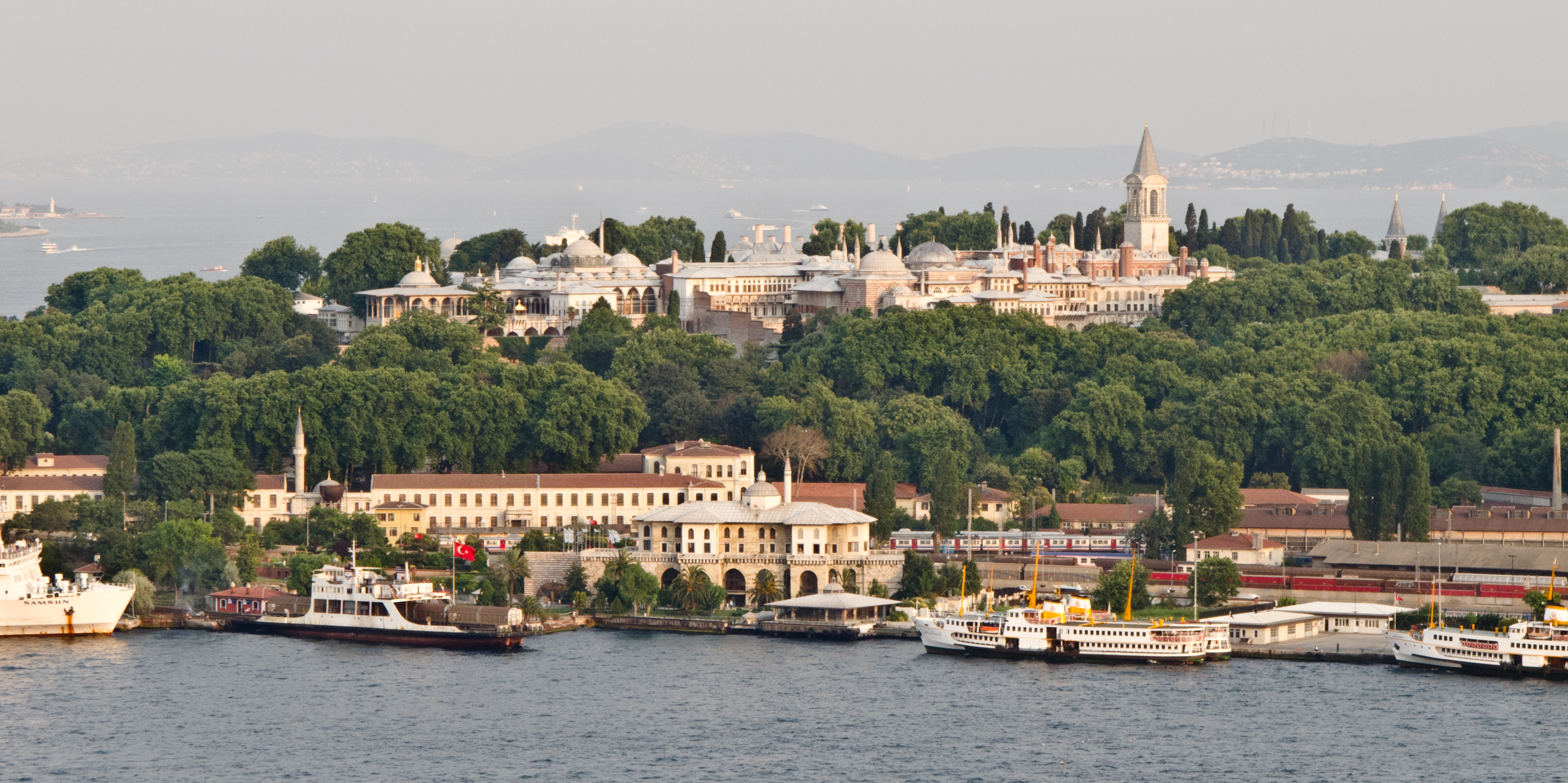
Sarayburnu ( tr, Sarayburnu, meaning ''Palace Cape''; known in English as the Seraglio Point) is a promontory quarter separating the Golden Horn and the Sea of Marmara in Istanbul, Turkey. The area is where the renowned Topkapı Palace and Gülhane Park stand. Sarayburnu is included in the historic areas of Istanbul, added to the UNESCO World Heritage List in 1985. History The first settlement on the Sarayburnu goes back to Neolithic, c. 6600 BC. The settlement lasted for almost a millennium before being inundated by the rising level of the sea; however, it might have been moved further inland. The artifacts from this settlement recovered during excavations display some of the distinct features of other artifacts found in other excavations in northwestern Turkey. Another settlement on the Sarayburnu, named Lygos, was founded by Thracian tribes between the 13th and 11th centuries BC, along with the neighbouring Semistra, which Pliny the Elder had mentioned in his historical a ... [...More Info...] [...Related Items...] OR: [Wikipedia] [Google] [Baidu] |
Topkapı - 01
Topkapı ("cannonball gate"), sometimes spelled Topkapi outside of Turkey, is a Turkish word that may refer to: * Topkapı Palace, a museum in Istanbul, Turkey * Topkapı Scroll, a Timurid dynasty pattern scroll in the museum's collection * Topkapı, Besni, a village in the district of Besni, Adıyaman Province, Turkey * Topkapı, Fatih, a neighbourhood of Istanbul near the Roman city walls * ''Topkapi'' (film), a 1964 caper movie * ''Topkapi'' (album), a 1965 album by jazz organist Jimmy McGriff * Nesrin Topkapı (born 1951), Turkish belly dancer * ''Topkapi'' (previous title ''The Light of Day'' (Eric Ambler novel)), a 1962 tragi-comic art heist spy novel by Eric Ambler Eric Clifford Ambler OBE (28 June 1909 – 22 October 1998) was an English author of thrillers, in particular spy novels, who introduced a new realism to the genre. Also working as a screenwriter, Ambler used the pseudonym Eliot Reed for book ... * Topkapı, Kemaliye {{disambiguation ... [...More Info...] [...Related Items...] OR: [Wikipedia] [Google] [Baidu] |
Thracians
The Thracians (; grc, Θρᾷκες ''Thrāikes''; la, Thraci) were an Indo-European languages, Indo-European speaking people who inhabited large parts of Eastern Europe, Eastern and Southeast Europe, Southeastern Europe in ancient history.. "The Thracians were an Indo-European people who occupied the area between northern Greece, southern Russia, and north-western Turkey. They shared the same language and culture... There may have been as many as a million Thracians, diveded among up to 40 tribes." Thracians resided mainly in the Balkans (mostly Present (time), modern day Bulgaria, Turkey and Greece) but were also located in Anatolia, Anatolia (Asia Minor) and other locations in Eastern Europe. The exact origin of Thracians is unknown, but it is believed that proto-Thracians descended from a purported mixture of Proto-Indo-Europeans and Early European Farmers, arriving from the rest of Asia and Africa through the Asia Minor (Anatolia). The proto-Thracian culture developed int ... [...More Info...] [...Related Items...] OR: [Wikipedia] [Google] [Baidu] |
Sirkeci
Sirkeci () is a neighborhood in the Eminönü quarter of the Fatih district in Istanbul, Turkey. The neighborhood borders to the north the mouth of the Golden Horn, to the west the neighborhood of Bahçekapı, to the east the Topkapı Palace area, and to the south the Cağaloğlu neighborhood. It hosts the Sirkeci railway station, the easternmost terminus of the Orient Express, a historic long-distance passenger train service in Europe that operated between Paris and Istanbul in the period between 1883 and 2009. The neighborhood consists mostly of commercial and tourist-oriented buildings. A combination of small shops, hans (larger workshops) and offices intermingle with boutique hotels, traditional Turkish restaurants, Turkish and foreign-language bookstores, and tourist offices. In the Byzantine period, the area was known as Prosphorion ( grc, Προσφόριον).Müller-Wiener (1977), p. 57 Accommodation In recent years, Sirkeci has become one of the major hotel neighbo ... [...More Info...] [...Related Items...] OR: [Wikipedia] [Google] [Baidu] |
Phoenicians
Phoenicia () was an ancient Semitic-speaking peoples, ancient thalassocracy, thalassocratic civilization originating in the Levant region of the eastern Mediterranean, primarily located in modern Lebanon. The territory of the Phoenician city-states extended and shrank throughout their history, and they possessed several enclaves such as Arwad and Tell Sukas (modern Syria). The core region in which the Phoenician culture developed and thrived stretched from Tripoli, Lebanon, Tripoli and Byblos in northern Lebanon to Mount Carmel in modern Israel. At their height, the Phoenician possessions in the Eastern Mediterranean stretched from the Orontes River mouth to Ashkelon. Beyond its homeland, the Phoenician civilization extended to the Mediterranean from Cyprus to the Iberian Peninsula. The Phoenicians were a Ancient Semitic-speaking peoples, Semitic-speaking people of somewhat unknown origin who Ethnogenesis, emerged in the Levant around 3000 BC. The term ''Phoenicia'' is an ancien ... [...More Info...] [...Related Items...] OR: [Wikipedia] [Google] [Baidu] |
Chalcolithic
The Copper Age, also called the Chalcolithic (; from grc-gre, χαλκός ''khalkós'', "copper" and ''líthos'', "stone") or (A)eneolithic (from Latin '' aeneus'' "of copper"), is an archaeological period characterized by regular human manipulation of copper, but prior to the discovery of bronze alloys. Modern researchers consider the period as a subset of the broader Neolithic, but earlier scholars defined it as a transitional period between the Neolithic and the Bronze Age. The archaeological site of Belovode, on Rudnik mountain in Serbia, has the world's oldest securely dated evidence of copper smelting at high temperature, from (7000 BP). The transition from Copper Age to Bronze Age in Europe occurred between the late 5th and the late In the Ancient Near East the Copper Age covered about the same period, beginning in the late and lasting for about a millennium before it gave rise to the Early Bronze Age. Terminology The multiple names result from m ... [...More Info...] [...Related Items...] OR: [Wikipedia] [Google] [Baidu] |
Bosporus
The Bosporus Strait (; grc, Βόσπορος ; tr, İstanbul Boğazı 'Istanbul strait', colloquially ''Boğaz'') or Bosphorus Strait is a natural strait and an internationally significant waterway located in Istanbul in northwestern Turkey. It forms part of the continental boundary between Asia and Europe, and divides Turkey by separating Anatolia from Thrace. It is the world's narrowest strait used for international navigation. Most of the shores of the Bosporus Strait, except for the area to the north, are heavily settled, with the city of Istanbul's metropolitan population of 17 million inhabitants extending inland from both banks. The Bosporus Strait and the Dardanelles Strait at the opposite end of the Sea of Marmara are together known as the Turkish Straits. Sections of the shore of the Bosporus in Istanbul have been reinforced with concrete or rubble and those sections of the Strait prone to deposition are periodically dredged. Name The name of th ... [...More Info...] [...Related Items...] OR: [Wikipedia] [Google] [Baidu] |
Anatolia
Anatolia, tr, Anadolu Yarımadası), and the Anatolian plateau, also known as Asia Minor, is a large peninsula in Western Asia and the westernmost protrusion of the Asian continent. It constitutes the major part of modern-day Turkey. The region is bounded by the Turkish Straits to the northwest, the Black Sea to the north, the Armenian Highlands to the east, the Mediterranean Sea to the south, and the Aegean Sea to the west. The Sea of Marmara forms a connection between the Black and Aegean seas through the Bosporus and Dardanelles straits and separates Anatolia from Thrace on the Balkan peninsula of Southeast Europe. The eastern border of Anatolia has been held to be a line between the Gulf of Alexandretta and the Black Sea, bounded by the Armenian Highlands to the east and Mesopotamia to the southeast. By this definition Anatolia comprises approximately the western two-thirds of the Asian part of Turkey. Today, Anatolia is sometimes considered to be synonymous with Asian ... [...More Info...] [...Related Items...] OR: [Wikipedia] [Google] [Baidu] |
Kadıköy
Kadıköy (), known in classical antiquity and during the Roman and Byzantine eras as Chalcedon ( gr, Χαλκηδών), is a large, populous, and cosmopolitan district in the Asian side of Istanbul, Turkey, on the northern shore of the Sea of Marmara. It partially faces the historic city centre of Fatih on the European side of the Bosporus. One of the expensive neighborhood in Istanbul. Kadıköy is also the name of the most prominent neighbourhood of the district, a residential and commercial area that, with its numerous bars, cinemas and bookshops, is the liberal cultural centre of the Anatolian side of Istanbul. Kadıköy became a district in 1928 when it was separated from Üsküdar district. The neighbourhoods of İçerenköy, Bostancı and Suadiye were also separated from the district of Kartal in the same year, and eventually joined the newly formed district of Kadıköy. Its neighbouring districts are Üsküdar to the northwest, Ataşehir to the northeast, Maltepe t ... [...More Info...] [...Related Items...] OR: [Wikipedia] [Google] [Baidu] |
Chalcedon
Chalcedon ( or ; , sometimes transliterated as ''Chalkedon'') was an ancient maritime town of Bithynia, in Asia Minor. It was located almost directly opposite Byzantium, south of Scutari (modern Üsküdar) and it is now a district of the city of Istanbul named Kadıköy. The name ''Chalcedon'' is a variant of Calchedon, found on all the coins of the town as well as in manuscripts of Herodotus's '' Histories'', Xenophon's '' Hellenica'', Arrian's ''Anabasis'', and other works. Except for the Maiden's Tower, almost no above-ground vestiges of the ancient city survive in Kadıköy today; artifacts uncovered at Altıyol and other excavation sites are on display at the Istanbul Archaeological Museum. The site of Chalcedon is located on a small peninsula on the north coast of the Sea of Marmara, near the mouth of the Bosphorus. A stream, called the Chalcis or Chalcedon in antiquity William Smith, LLD, ed. (1854). '' Dictionary of Greek and Roman Geography''"Chalcedon" and now kno ... [...More Info...] [...Related Items...] OR: [Wikipedia] [Google] [Baidu] |
Byzas
Byzas (Ancient Greek: Βύζας, ''Býzas'') was the legendary founder of Byzantium (Ancient Greek: Βυζάντιον, ''Byzántion''), the city later known as Constantinople and then Istanbul. Background The legendary history of the founding of Byzantium as recorded by later Byzantine authors is most fully preserved in the ''Patria of Constantinople'' by 6th century writer Hesychius of Miletus. The ''Patria'' recorded multiple versions of the city's founding myth. Hesychius' preferred account says the city received its name from Io, daughter of the Argive king, who was raped by Inachus and then transformed into a cow. Zeus had fallen in love with Io, and in a jealous fit, Hera sent a gadfly to drive Io from one place to another in torment until she arrived in Thrace, giving birth to Ceroessa, the mother of Byzas by Poseidon, for whom the Golden Horn was named ''Ceras''. One tradition holds that the city was founded by the Argives who received an oracle at Delphi with referen ... [...More Info...] [...Related Items...] OR: [Wikipedia] [Google] [Baidu] |
Megara
Megara (; el, Μέγαρα, ) is a historic town and a municipality in West Attica, Greece. It lies in the northern section of the Isthmus of Corinth opposite the island of Salamis Island, Salamis, which belonged to Megara in archaic times, before being taken by Athens. Megara was one of the four districts of Attica, embodied in the four mythic sons of King Pandion II, of whom Nisos was the ruler of Megara. Megara was also a trade port, its people using their ships and wealth as a way to gain leverage on armies of neighboring poleis. Megara specialized in the exportation of wool and other animal products including livestock such as horses. It possessed two harbors, Pagae to the west on the Corinthian Gulf, and Nisaea to the east on the Saronic Gulf of the Aegean Sea. It is part of Athens metropolitan area. Early history According to Pausanias (geographer), Pausanias, the Megarians said that their town owed its origin to Car (Greek mythology), Car, the son of Phoroneus, who bui ... [...More Info...] [...Related Items...] OR: [Wikipedia] [Google] [Baidu] |
Ancient Greece
Ancient Greece ( el, Ἑλλάς, Hellás) was a northeastern Mediterranean civilization, existing from the Greek Dark Ages of the 12th–9th centuries BC to the end of classical antiquity ( AD 600), that comprised a loose collection of culturally and linguistically related city-states and other territories. Most of these regions were officially unified only once, for 13 years, under Alexander the Great's empire from 336 to 323 BC (though this excludes a number of Greek city-states free from Alexander's jurisdiction in the western Mediterranean, around the Black Sea, Cyprus, and Cyrenaica). In Western history, the era of classical antiquity was immediately followed by the Early Middle Ages and the Byzantine period. Roughly three centuries after the Late Bronze Age collapse of Mycenaean Greece, Greek urban poleis began to form in the 8th century BC, ushering in the Archaic period and the colonization of the Mediterranean Basin. This was followed by the age of Classical G ... [...More Info...] [...Related Items...] OR: [Wikipedia] [Google] [Baidu] |


.jpg)


.jpg)