|
Sequoyah County, Oklahoma
Sequoyah County is a county located in the U.S. state of Oklahoma. As of the 2020 census, the population was 39,281. The county seat is Sallisaw. Sequoyah County was created in 1907 when Oklahoma became a state. It was named after Sequoyah, who created the Cherokee syllabary and its written language. William L. Anderson, "Sequoyah County." ''Encyclopedia of Oklahoma History and Culture''. Accessed May 23, 2012. Sequoyah County is part of the Fort Smith, AR-OK Metropolitan Statistical ...
[...More Info...] [...Related Items...] OR: [Wikipedia] [Google] [Baidu] |
Sequoyah
Sequoyah (Cherokee language, Cherokee: ᏍᏏᏉᏯ, ''Ssiquoya'', or ᏎᏉᏯ, ''Se-quo-ya''; 1770 – August 1843), also known as George Gist or George Guess, was a Native Americans in the United States, Native American polymath of the Cherokee Nation. In 1821, he completed his independent creation of the Cherokee syllabary, making Reading (process), reading and writing in Cherokee possible. His achievement was one of the few times in recorded history that an individual who was a member of a pre-literate group created an original, effective writing system. His creation of the syllabary allowed the Cherokee nation to be one of the first North American Indigenous groups to have a written language. Sequoyah was also an important representative for the Cherokee nation, by going to Washington, D.C. to sign two relocations and trading of land treaties. After seeing its worth, the people of the Cherokee Nation (19th century), Cherokee Nation rapidly began to use his syllabary and ... [...More Info...] [...Related Items...] OR: [Wikipedia] [Google] [Baidu] |
Indian Removal
Indian removal was the United States government policy of forced displacement of self-governing tribes of Native Americans from their ancestral homelands in the eastern United States to lands west of the Mississippi Riverspecifically, to a designated Indian Territory (roughly, present-day Oklahoma). The Indian Removal Act, the key law which authorized the removal of Native tribes, was signed by Andrew Jackson in 1830. Although Jackson took a hard line on Indian removal, the law was enforced primarily during the Martin Van Buren administration. After the passage of the Indian Removal Act in 1830, approximately 60,000 members of the Cherokee, Muscogee (Creek), Seminole, Chickasaw, and Choctaw nations (including thousands of their black slaves) were forcibly removed from their ancestral homelands, with thousands dying during the Trail of Tears. Indian removal, a popular policy among incoming settlers, was a consequence of actions by European settlers in North America during th ... [...More Info...] [...Related Items...] OR: [Wikipedia] [Google] [Baidu] |
Cookson Hills
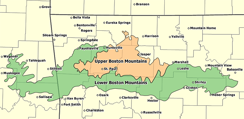
The Cookson Hills are in eastern Oklahoma. They are an extension of the Boston Mountains of Arkansas to the east and the southwestern margin of the Ozark Plateau. They lie generally between Stilwell, Sallisaw and Tahlequah. The area became part of the Cherokee Nation in the early 20th century until 1907, when Oklahoma became a state. History The Depression-era bank robber Charles Arthur ("Pretty Boy") Floyd was raised in the Cookson Hills. Geography The region is a rugged dissected plateau with numerous peaks and ridges up to above sea level. The Cooksons are drained by tributaries of the Illinois River (Arkansas). They are heavily wooded, predominantly oak An oak is a tree or shrub in the genus ''Quercus'' (; Latin "oak tree") of the beech family, Fagaceae. There are approximately 500 extant species of oaks. The common name "oak" also appears in the names of species in related genera, notably ''L ..., with patches of black walnut and hickory trees. The J. T. Nick ... [...More Info...] [...Related Items...] OR: [Wikipedia] [Google] [Baidu] |
Ouachita Mountains
The Ouachita Mountains (), simply referred to as the Ouachitas, are a mountain range in western Arkansas and southeastern Oklahoma. They are formed by a thick succession of highly deformed Paleozoic strata constituting the Ouachita Fold and Thrust Belt, one of the important orogenic belts of North America. The Ouachitas continue in the subsurface to the northeast, where they make a poorly understood connection with the Appalachians and to the southwest, where they join with the Marathon uplift area of West Texas. Together with the Ozark Plateaus, the Ouachitas form the U.S. Interior Highlands. The highest natural point is Mount Magazine at . The Ouachita Mountains is a Level III ecoregion designated by the Environmental Protection Agency (EPA). The region has been subdivided into six Level IV ecoregions. Etymology Louis R. Harlan claimed that "Ouachita" is composed of the Choctaw words ''ouac'' for "buffalo" and ''chito'' for "large", together meaning "country of large buffa ... [...More Info...] [...Related Items...] OR: [Wikipedia] [Google] [Baidu] |
Ozark Plateau
The Ozarks, also known as the Ozark Mountains, Ozark Highlands or Ozark Plateau, is a physiographic region in the U.S. states of Missouri, Arkansas, Oklahoma and the extreme southeastern corner of Kansas. The Ozarks cover a significant portion of northern Arkansas and most of the southern half of Missouri, extending from Interstate 40 in central Arkansas to Interstate 70 in central Missouri. There are two mountain ranges in the Ozarks: the Boston Mountains of Arkansas and the St. Francois Mountains of Missouri. Buffalo Lookout, the highest point in the Ozarks, is located in the Boston Mountains. Geologically, the area is a broad dome with the exposed core in the ancient St. Francois Mountains. The Ozarks cover nearly , making it the most extensive highland region between the Appalachians and Rockies. Together with the Ouachita Mountains, the area is known as the U.S. Interior Highlands. The Salem Plateau, named after Salem, Missouri, makes up the largest geologic area of the ... [...More Info...] [...Related Items...] OR: [Wikipedia] [Google] [Baidu] |
United States Census Bureau
The United States Census Bureau (USCB), officially the Bureau of the Census, is a principal agency of the U.S. Federal Statistical System, responsible for producing data about the American people and economy. The Census Bureau is part of the U.S. Department of Commerce and its director is appointed by the President of the United States. The Census Bureau's primary mission is conducting the U.S. census every ten years, which allocates the seats of the U.S. House of Representatives to the states based on their population. The bureau's various censuses and surveys help allocate over $675 billion in federal funds every year and it assists states, local communities, and businesses make informed decisions. The information provided by the census informs decisions on where to build and maintain schools, hospitals, transportation infrastructure, and police and fire departments. In addition to the decennial census, the Census Bureau continually conducts over 130 surveys and programs ... [...More Info...] [...Related Items...] OR: [Wikipedia] [Google] [Baidu] |
Arkansas River
The Arkansas River is a major tributary of the Mississippi River. It generally flows to the east and southeast as it traverses the U.S. states of Colorado, Kansas, Oklahoma, and Arkansas. The river's source basin lies in the western United States in Colorado, specifically the Arkansas River Valley. The headwaters derive from the snowpack in the Sawatch and Mosquito mountain ranges. It flows east into the Midwest via Kansas, and finally into the South through Oklahoma and Arkansas. At , it is the sixth-longest river in the United States, the second-longest tributary in the Mississippi–Missouri system, and the 45th longest river in the world. Its origin is in the Rocky Mountains in Lake County, Colorado, near Leadville. In 1859, placer gold discovered in the Leadville area brought thousands seeking to strike it rich, but the easily recovered placer gold was quickly exhausted. The Arkansas River's mouth is at Napoleon, Arkansas, and its drainage basin covers nearly .See wat ... [...More Info...] [...Related Items...] OR: [Wikipedia] [Google] [Baidu] |
Ambush Of The Steamboat J
An ambush is a long-established military tactic in which a combatant uses an advantage of concealment or the element of surprise to attack unsuspecting enemy combatants from concealed positions, such as among dense underbrush or behind mountaintops. Ambushes have been used consistently throughout history, from ancient to modern warfare. In the 20th century, an ambush might involve thousands of soldiers on a large scale, such as over a choke point such as a mountain pass, or a small irregulars band or insurgent group attacking a regular armed force patrols. Theoretically, a single well-armed and concealed soldier could ambush other troops in a surprise attack. Sometimes an ambush can involve the exclusive or combined use of improvised explosive devices, that allow the attackers to hit enemy convoys or patrols while minimizing the risk of being exposed to return fire. History This use by early people of ambushing may date as far back as two million years when anthropologists ... [...More Info...] [...Related Items...] OR: [Wikipedia] [Google] [Baidu] |
Stand Watie
Brigadier-General Stand Watie ( chr, ᏕᎦᏔᎦ, translit=Degataga, lit=Stand firm; December 12, 1806September 9, 1871), also known as Standhope Uwatie, Tawkertawker, and Isaac S. Watie, was a Cherokee politician who served as the second principal chief of the Cherokee Nation from 1862 to 1866. The Cherokee Nation allied with the Confederate States during the American Civil War and he was the only Native American Confederate general officer of the war. Watie commanded Indian forces in the Trans-Mississippi Theater, made up mostly of Cherokee, Muskogee, and Seminole. He was the last Confederate States Army general to surrender. Before removal of the Cherokee to Indian Territory in the late 1830s, Watie and his older brother Elias Boudinot were among Cherokee leaders who signed the Treaty of New Echota in 1835. The majority of the tribe opposed their action. In 1839, the brothers were attacked in an assassination attempt, as were other relatives active in the Treaty Party. A ... [...More Info...] [...Related Items...] OR: [Wikipedia] [Google] [Baidu] |
Tahlequah, Oklahoma
Tahlequah ( ; ''Cherokee'': ᏓᎵᏆ, ''daligwa'' ) is a city in Cherokee County, Oklahoma located at the foothills of the Ozark Mountains. It is part of the Green Country region of Oklahoma and was established as a capital of the 19th-century Cherokee Nation in 1839, as part of the new settlement in Indian Territory after the Cherokee Native Americans were forced west from the American Southeast on the Trail of Tears. The city's population was 15,753 at the 2010 census, an increase of 8.96 percent over the figure of 14,458 reported in 2000. The 2019 estimated population is 16,819. Tahlequah is the capital of the two federally recognized Cherokee tribes based in Oklahoma, the modern Cherokee Nation and the United Keetoowah Band of Cherokee Indians. Tahlequah is also the county seat of Cherokee County. The main campus of Northeastern State University is located in the city. History Background Tahlonteeskee was the first established governmental capital of any kind in what ... [...More Info...] [...Related Items...] OR: [Wikipedia] [Google] [Baidu] |
Gore, Oklahoma
Gore is a town in western Sequoyah County, Oklahoma, United States. It is part of the Fort Smith, Arkansas-Oklahoma Metropolitan Statistical Area. The population was 977 at the 2010 census, an increase of 15 percent over the figure of 850 recorded in 2000. Gore claims to be the "trout capital of Oklahoma", with great fishing in Lake Tenkiller, the Illinois River, and the Arkansas River. History This community began as a small settlement in Indian Territory known as Campbell, named for Dr. W. W. Campbell, who, along with Joe Lynch, operated a ferry across the Arkansas River between Campbell and Webbers Falls. Tahlonteskee, the capital of the Western Cherokee from 1828–1839, was near here, just two miles to the north of town. In 1829, John Jolly, chief of the Cherokee Nation–West, built a home in this area. The settlement was also known as Illinois Station or "Illinois Station, Campbell Post Office." It became a stage stop on the route between Fort Gibson and Fort Smith ... [...More Info...] [...Related Items...] OR: [Wikipedia] [Google] [Baidu] |
Tahlonteeskee, Oklahoma
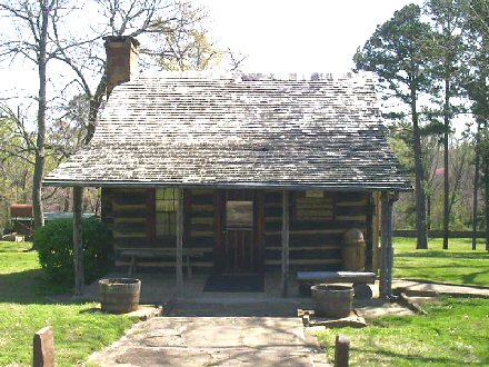
Tahlonteeskee, Oklahoma (Cherokee variant: ''Tahlontuskey'') was the first capital city of the early western Cherokee Nation. It was named for Tahlonteeskee, who was the third Principal Chief of the Cherokee Nation -West (1817–1819). Today, the area of the settlement is an abandoned, barren site on private land in Sequoyah County. History The area in which Tahlonteeskee was located was part of the 1816 Lovely's Purchase.''Sequoyah County'' Oklahoma Historical Society online; accessed April 2018 The town itself was founded in 1828, near the mouth of the Illinois River, and became the capital of the Cherokee "''''" living in the Che ... [...More Info...] [...Related Items...] OR: [Wikipedia] [Google] [Baidu] |


