|
Semidi Islands
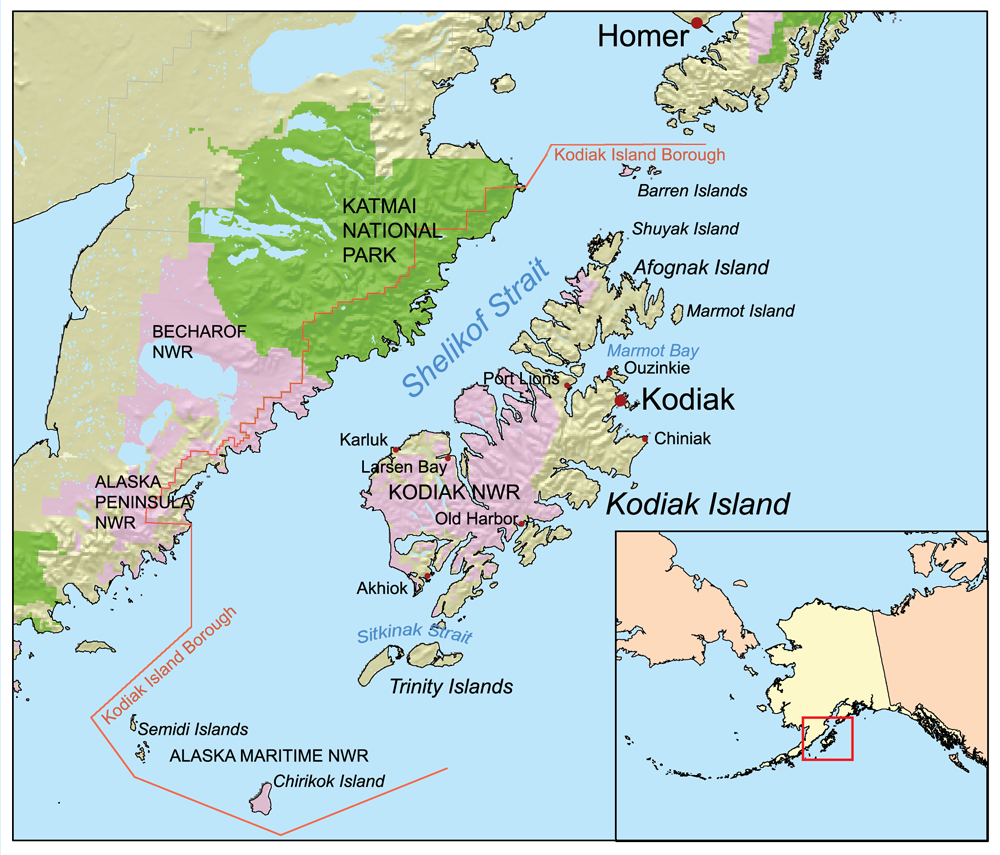
The Semidi Islands are a group of islands of the state of Alaska, United States, lying offshore in the Gulf of Alaska. The islands are part of Kodiak Island Borough and are located southwest of Kodiak Island, about halfway between the Alaska Peninsula mainland and Chirikof Island. The largest islands of the group are Aghiyuk Island and Chowiet Island. The island group has a total land area of 30.178 km2 (11.652 sq mi) and is uninhabited. They are part of the Alaska Peninsula unit of the Alaska Maritime National Wildlife Refuge. Wilderness Before being combined with other wilderness areas to form the Alaska Maritime National Wildlife Refuge in 1980, the Semidi Wilderness was known as the Semidi National Wildlife Refuge. The 250,000 acre wilderness area Wilderness or wildlands (usually in the plural), are natural environments on Earth that have not been significantly modified by human activity or any nonurbanized land not under extensive agricultural cultivation. The te ... [...More Info...] [...Related Items...] OR: [Wikipedia] [Google] [Baidu] |
Kodiak Island Map In Alaska
Kodiak may refer to: Places *Kodiak, Alaska, a city located on Kodiak island * Kodiak, Missouri, an unincorporated community *Kodiak Archipelago, in southern Alaska *Kodiak Island, the largest island of the Kodiak archipelago ** Kodiak Launch Complex, a commercial spaceport on Kodiak Island * Kodiak Island Borough, Alaska, a borough mostly located on the island * Kodiak National Wildlife Refuge, a wilderness area in the Kodiak Archipelago * Kodiak Seamount, the oldest seamount of the Kodiak-Bowie Seamount chain Arts, entertainment, and media * ''Kodiak'' (TV series), a television program that aired Fridays on ABC, during the 1974-75 television season in the United States * ''Kodiak'' or GDSS ''Kodiak'', a large spaceship in the second and fourth video games of the Command & Conquer: Tiberian series * ''Kodiak'', a combat unit ("mech") in the MechWarrior 2: 31st Century Combat ''Ghost Bear'' expansion * Kodi (full name: ''Kodiak''), a fictional character in ''Balto III: Wings of ... [...More Info...] [...Related Items...] OR: [Wikipedia] [Google] [Baidu] |
Alaska
Alaska ( ; russian: Аляска, Alyaska; ale, Alax̂sxax̂; ; ems, Alas'kaaq; Yup'ik: ''Alaskaq''; tli, Anáaski) is a state located in the Western United States on the northwest extremity of North America. A semi-exclave of the U.S., it borders the Canadian province of British Columbia and the Yukon territory to the east; it also shares a maritime border with the Russian Federation's Chukotka Autonomous Okrug to the west, just across the Bering Strait. To the north are the Chukchi and Beaufort Seas of the Arctic Ocean, while the Pacific Ocean lies to the south and southwest. Alaska is by far the largest U.S. state by area, comprising more total area than the next three largest states (Texas, California, and Montana) combined. It represents the seventh-largest subnational division in the world. It is the third-least populous and the most sparsely populated state, but by far the continent's most populous territory located mostly north of the 60th parallel, ... [...More Info...] [...Related Items...] OR: [Wikipedia] [Google] [Baidu] |
Gulf Of Alaska
The Gulf of Alaska (Tlingit: ''Yéil T'ooch’'') is an arm of the Pacific Ocean defined by the curve of the southern coast of Alaska, stretching from the Alaska Peninsula and Kodiak Island in the west to the Alexander Archipelago in the east, where Glacier Bay and the Inside Passage are found. The Gulf shoreline is a combination of forest, mountain and a number of tidewater glaciers. Alaska's largest glaciers, the Malaspina Glacier and Bering Glacier, spill out onto the coastal line along the Gulf of Alaska. The coast is heavily indented with Cook Inlet and Prince William Sound, the two largest connected bodies of water. It includes Yakutat Bay and Cross Sound. Lituya Bay (a fjord north of Cross Sound, and south of Mount Fairweather) is the site of the largest recorded tsunami in history. It serves as a sheltered anchorage for fishing boats. Ecology The Gulf of Alaska is considered a Class I, productive ecosystem with more than 300 grams of carbon per square meter per ... [...More Info...] [...Related Items...] OR: [Wikipedia] [Google] [Baidu] |
Kodiak Island Borough, Alaska
Kodiak Island Borough (russian: Остров Кадьяк) is a borough in the U.S. state of Alaska. At the 2020 census, the population was 13,101, down from 13,592 in 2010. The borough seat is Kodiak. Geography The borough has a total area of , of which is land and (45.5%) is water. Most of the land area belongs to Kodiak Island, but a thin strip of coastal area on the western part of the Alaska Peninsula and other nearby islands (Afognak Island, Shuyak Island, Marmot Island, Raspberry Island, Little Raspberry Island, Whale Island, Spruce Island, Woody Island, Uganik Island, Sitkalidak Island, Tugidak Island, Sitkinak Island, Chirikof Island, and the Semidi Islands) are also in the borough. The waterway between the island and mainland is known as the Shelikof Strait. South of the island are the open waters of the Pacific Ocean, so the site is considered good for launching certain types of satellites. The Kodiak Launch Complex is ideal for putting satellites in Mo ... [...More Info...] [...Related Items...] OR: [Wikipedia] [Google] [Baidu] |
Kodiak Island
Kodiak Island ( Alutiiq: ''Qikertaq''), is a large island on the south coast of the U.S. state of Alaska, separated from the Alaska mainland by the Shelikof Strait. The largest island in the Kodiak Archipelago, Kodiak Island is the second largest island in the United States and the 80th largest island in the world, with an area of , slightly larger than Cyprus. It is long and in width ranges from . Kodiak Island is the namesake for Kodiak Seamount, which lies off the coast at the Aleutian Trench. The largest community on the island is the city of Kodiak, Alaska. Kodiak Island is mountainous and heavily forested in the north and east, but fairly treeless in the south. The island has many deep, ice-free bays that provide sheltered anchorages for boats. The southwestern two-thirds of the island, like much of the Kodiak Archipelago, is part of Kodiak National Wildlife Refuge. Kodiak Island is part of the Kodiak Island Borough and Kodiak Archipelago of Alaska. The town of K ... [...More Info...] [...Related Items...] OR: [Wikipedia] [Google] [Baidu] |
Alaska Peninsula
The Alaska Peninsula (also called Aleut Peninsula or Aleutian Peninsula, ale, Alasxix̂; Sugpiaq: ''Aluuwiq'', ''Al'uwiq'') is a peninsula extending about to the southwest from the mainland of Alaska and ending in the Aleutian Islands. The peninsula separates the Pacific Ocean from Bristol Bay, an arm of the Bering Sea. In literature (especially Russian) the term "Alaska Peninsula" was used to denote the entire northwestern protrusion of the North American continent, or all of what is now the state of Alaska, exclusive of its panhandle and islands. The Lake and Peninsula borough, the Alaskan equivalent of a county, is named after the peninsula. The Alaska/Aleutian Peninsula is also grouped into Southwest Alaska. The other largest peninsulas in Alaska include the Kenai Peninsula and Seward Peninsula. Geography The base of the Alaska Peninsula extends out from the end of the Alaska Range. The Aleutian Range is a highly active volcanic mountain range which runs ... [...More Info...] [...Related Items...] OR: [Wikipedia] [Google] [Baidu] |
Chirikof Island
Chirikof Island (russian: Остров Чирикова) is located in the Gulf of Alaska approximately southwest of Kodiak Island. Terrain Chirikof Island consists of of grasses and sedges. Treeless, it lies west of the western tree line in Alaska. The island is shaped like a webbed duck foot with the heel to the north and the webbing to the south. The seas around Chirikof are treacherous and the island has a history of shipwrecks. The south shore has a wide beach suitable for aircraft landings and cautious watercraft landings. The island is open to general public access. Commercial carriers need a permit to visit; personal planes or boats need no permit. Habitation The first human inhabitants of the island were the Old Islanders, 4000-2000 BP (before present, i.e., before 1950.) A subsistence village existed up to the late 19th century, when it was succeeded first by fox farming and then by cattle farming. There has generally been continuous human habitation of Chirikof, relie ... [...More Info...] [...Related Items...] OR: [Wikipedia] [Google] [Baidu] |
Alaska Maritime National Wildlife Refuge
The Alaska Maritime National Wildlife Refuge (often shortened to Alaska Maritime or AMNWR) is a United States National Wildlife Refuge comprising 2,400 islands, headlands, rocks, islets, spires and reefs in Alaska, with a total area of , of which is wilderness. The refuge stretches from Cape Lisburne on the Chukchi Sea to the tip of the Aleutian Islands in the west and Forrester Island in the southern Alaska Panhandle region in the east. The refuge has diverse landforms and terrains, including tundra, rainforest, cliffs, volcanoes, beaches, lakes, and streams. Alaska Maritime National Wildlife Refuge is well known for its abundance of seabirds. About 75 percent of Alaskan native marine birds, 15 to 30 million among 55 species, use the refuge. AMNWR also provides a nesting habitat for an estimated 40 million seabirds, representing 80 percent of all seabirds in North America. The birds congregate in "bird cities" (colonies) along the coast. Each species has a specialized nestin ... [...More Info...] [...Related Items...] OR: [Wikipedia] [Google] [Baidu] |
Wilderness Area
Wilderness or wildlands (usually in the plural), are natural environments on Earth that have not been significantly modified by human activity or any nonurbanized land not under extensive agricultural cultivation. The term has traditionally referred to terrestrial environments, though growing attention is being placed on marine wilderness. Recent maps of wilderness suggest it covers roughly one quarter of Earth's terrestrial surface, but is being rapidly degraded by human activity. Even less wilderness remains in the ocean, with only 13.2% free from intense human activity. Some governments establish protection for wilderness areas by law to not only preserve what already exists, but also to promote and advance a natural expression and development. These can be set up in preserves, conservation preserves, national forests, national parks and even in urban areas along rivers, gulches or otherwise undeveloped areas. Often these areas are considered important for the survival of ... [...More Info...] [...Related Items...] OR: [Wikipedia] [Google] [Baidu] |
Horned Puffins
The horned puffin (''Fratercula corniculata'') is an auk found in the North Pacific Ocean, including the coasts of Alaska, Siberia and British Columbia. It is a pelagic seabird that feeds primarily by diving for fish. It nests in colonies, often with other auks. It is similar in appearance to the Atlantic puffin, its closest relative of the North Atlantic, but differs by a "horn" of black skin located above the eye, present in adult birds. Etymology The binomial name of this species, ''Fratercula corniculata'', comes from the Medieval Latin ''fratercula'', meaning “friar”; their black-and-white plumage resembling the robes of monks. ''Corniculata'' means “horn-shaped” or “crescent-shaped”, in reference to the black horn above the bird's eye. The vernacular name ''puffin'' – puffed in the sense of swollen – was originally applied to the fatty, salted meat of young birds of the unrelated species, the Manx shearwater (''Puffinus puffinus''), formerly known as the ... [...More Info...] [...Related Items...] OR: [Wikipedia] [Google] [Baidu] |


