|
Scotlandwell
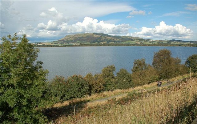
Scotlandwell is a village in Portmoak, Kinross-shire, Scotland. It is within the Perth and Kinross council area. It lies to the east of Loch Leven, at the junction of the A977 and B920 roads, approximately west of Glenrothes and east of Kinross. Scotlandwell is one of the historic sites of Kinross-shire. Named Fons Scotiae by the Romans who founded it nearly 2,000 years ago, the curative waters that bubble up through the sandy ground were used by Red Friars who maintained a hospital in the village between 1250 and 1587. Thousands of pilgrims came to Scotlandwell to take the water, the most famous perhaps being King Robert the Bruce who is alleged to have found a cure for leprosy here. The two main historical features of Scotlandwell village are the Well and Wash House. The Well and Wash House The building of the ornamental well and wash house in Scotlandwell in more recent times was undertaken as part of a general scheme of village improvement carried out between 1857 ... [...More Info...] [...Related Items...] OR: [Wikipedia] [Google] [Baidu] |
Portmoak
Portmoak is a parish in Kinross-shire, Scotland. It consists of a group of settlements running north to south: Glenlomond, Wester Balgedie, Easter Balgedie, Kinnesswood, Kilmagadwood and Scotlandwell. The name derives from the Port of St Moak (an alternative name for St Monan), being a port in relation to Loch Leven The main villages are Kinnesswood (where the Post Office is situated) and Scotlandwell. Geography The parish is on the east side of Kinross-shire lying between Loch Leven and Fife. It is bounded by the parishes of Cleish, Kinross, Orwell, Strathmiglo, Falkland, Leslie, Kinglassie, Auchterderran and Ballingry. The area is a rich landscape of braes, crags, fine meadows, fertile fields and plantations. Bishop Hill The entire area of Portmoak is dominated by Bishop Hill, 500 ft (460 m) high, one of the Lomond Hills, known locally as "the bishop". On its lower reaches are oak, rowan and Scots pine. It is best approached by walkers from Scotlandwell. A ... [...More Info...] [...Related Items...] OR: [Wikipedia] [Google] [Baidu] |
Kinross-shire
The County of Kinross or Kinross-shire is a historic county and registration county in eastern Scotland, administered as part of Perth and Kinross since 1930. Surrounding its largest settlement and county town of Kinross, the county borders Perthshire to the north and Fife to the east, south and west. Scotland's second smallest county, Kinross-shire is dominated by Loch Leven, a large inland loch, with two islands and an internationally important nature reserve. One of the islands contains a castle, where Mary, Queen of Scots was once held prisoner. Much of the land in Kinross-shire is fertile agricultural land and most of the inhabitants were originally employed in farming. The gently-rolling farmland surrounding Loch Leven gives way to steep, more rugged terrain at the outskirts of the county. History The shire or sheriffdom of Kinross was formed in the thirteenth century when the two parishes of Kinross and Orwell were removed from the Fothriff area of Fife. Cleish, Portm ... [...More Info...] [...Related Items...] OR: [Wikipedia] [Google] [Baidu] |
Perth And Kinross
Perth and Kinross ( sco, Pairth an Kinross; gd, Peairt agus Ceann Rois) is one of the 32 council areas of Scotland and a Lieutenancy Area. It borders onto the Aberdeenshire, Angus, Argyll and Bute, Clackmannanshire, Dundee, Fife, Highland and Stirling council areas. Perth is the administrative centre. With the exception of a large area of south-western Perthshire, the council area mostly corresponds to the historic counties of Perthshire and Kinross-shire. Perthshire and Kinross-shire shared a joint county council from 1929 until 1975. The area formed a single local government district in 1975 within the Tayside region under the ''Local Government (Scotland) Act 1973'', and was then reconstituted as a unitary authority (with a minor boundary adjustment) in 1996 by the ''Local Government etc. (Scotland) Act 1994''. Geographically the area is split by the Highland Boundary Fault into a more mountainous northern part and a flatter southern part. The northern area is a popular to ... [...More Info...] [...Related Items...] OR: [Wikipedia] [Google] [Baidu] |
Ancient Rome
In modern historiography, ancient Rome refers to Roman civilisation from the founding of the city of Rome in the 8th century BC to the collapse of the Western Roman Empire in the 5th century AD. It encompasses the Roman Kingdom (753–509 BC), Roman Republic (509–27 BC) and Roman Empire (27 BC–476 AD) until the fall of the western empire. Ancient Rome began as an Italic settlement, traditionally dated to 753 BC, beside the River Tiber in the Italian Peninsula. The settlement grew into the city and polity of Rome, and came to control its neighbours through a combination of treaties and military strength. It eventually dominated the Italian Peninsula, assimilated the Greek culture of southern Italy ( Magna Grecia) and the Etruscan culture and acquired an Empire that took in much of Europe and the lands and peoples surrounding the Mediterranean Sea. It was among the largest empires in the ancient world, with an estimated 50 to 90 million inhabitants, roughly 20% of t ... [...More Info...] [...Related Items...] OR: [Wikipedia] [Google] [Baidu] |


.jpg)
