|
San Pedro Columbia
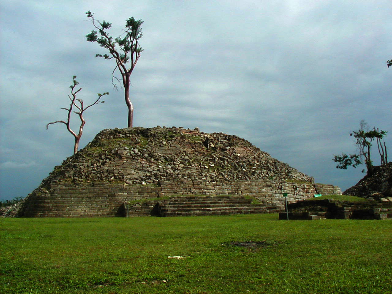
San Pedro Columbia is a village in Toledo District, Belize, located about two miles from the ancient Maya ruins of Lubaantun. In 2000 San Pedro Columbia had a population of about 700 people. The population is mostly Kekchi Maya with some Mopan Maya. San Pedro Columbia has Belize's largest settlement of Kekchi. Most of the population came to Belize from the Petén region of Guatemala in the late 19th century. The village is known for the hand woven embroidery produced there. Ancient history Lubaantun is one of the area's pre-Columbian Maya sites, inhabited at least as early as the Maya Classic Period. Lubaantun has unusual features of construction including drystone Dry stone, sometimes called drystack or, in Scotland, drystane, is a building method by which structures are constructed from stones without any mortar to bind them together. Dry stone structures are stable because of their construction m ... work and rounded corners that set it apart from other Maya sit ... [...More Info...] [...Related Items...] OR: [Wikipedia] [Google] [Baidu] |
List Of Sovereign States
The following is a list providing an overview of sovereign states around the world with information on their status and recognition of their sovereignty. The 206 listed states can be divided into three categories based on membership within the United Nations System: 193 UN member states, 2 UN General Assembly non-member observer states, and 11 other states. The ''sovereignty dispute'' column indicates states having undisputed sovereignty (188 states, of which there are 187 UN member states and 1 UN General Assembly non-member observer state), states having disputed sovereignty (16 states, of which there are 6 UN member states, 1 UN General Assembly non-member observer state, and 9 de facto states), and states having a special political status (2 states, both in free association with New Zealand). Compiling a list such as this can be a complicated and controversial process, as there is no definition that is binding on all the members of the community of nations concerni ... [...More Info...] [...Related Items...] OR: [Wikipedia] [Google] [Baidu] |
Lubaantun
Lubaantun (pronounced /lubaːnˈtun/; also Lubaantún in Spanish orthography) is a pre-Columbian ruined city of the Maya civilization in southern Belize, Central America. Lubaantun is in Belize's Toledo District, about 42 kilometres (26 mi) northwest of Punta Gorda, and approximately 3.2 kilometres (2 mi) from the village of San Pedro Columbia, at an elevation of 61 metres (200 ft) feet above mean sea level. One of the most distinguishing features of Lubaantun is the large collection of miniature ceramic objects found on site; these detailed constructs are thought to have been charmstones or ritual-accompanying accoutrements. The city dates from the Maya Classic era, flourishing from the AD 730s to the 890s, and seems to have been completely abandoned soon after. The architecture is somewhat unusual from typical Classical central lowlands Maya sites. Lubaantun's structures are mostly built of large stone blocks laid with no mortar, primarily black slate rather tha ... [...More Info...] [...Related Items...] OR: [Wikipedia] [Google] [Baidu] |
Drystone
Dry stone, sometimes called drystack or, in Scotland, drystane, is a building method by which structures are constructed from stones without any mortar to bind them together. Dry stone structures are stable because of their construction method, which is characterized by the presence of a load-bearing façade of carefully selected interlocking stones. Dry stone construction is best known in the context of stone walls, traditionally used for the boundaries of fields and churchyards, or as retaining walls for terracing, but dry stone sculptures, buildings, bridges, and other structures also exist. The term tends not to be used for the many historic styles which used precisely-shaped stone, but did not use mortar, for example the Greek temple and Inca architecture. The art of dry stone walling was inscribed in 2018 on the UNESCO representative list of the intangible cultural heritage of humanity, for dry stone walls in countries such as France, Greece, Italy, Slovenia, Cro ... [...More Info...] [...Related Items...] OR: [Wikipedia] [Google] [Baidu] |
Mesoamerican Chronology
Mesoamerican chronology divides the history of pre-Columbian, prehispanic Mesoamerica into several periods: the Paleo-Indian (first human habitation until 3500 BCE); the Archaic (before 2600 BCE), the Preclassic or Formative (2500 BCE – 250 CE), the Classic (250–900 CE), and the Postclassic (); as well as the post European contact Colonial Period (1521–1821), and Postcolonial, or the period after independence from Spain (1821–present). The periodisation of Mesoamerica by researchers is based on archaeological, ethnohistorical, and modern cultural anthropology research dating to the early twentieth century. Archaeologists, ethnohistorians, historians, and cultural anthropologists continue to work to develop cultural histories of the region. Overview Paleo-Indian period 10,000–3500 BCE The Paleo-Indian (less frequently, ''Lithic stage, Lithic'') period or era is that which spans from the first signs of human presence in the region, to t ... [...More Info...] [...Related Items...] OR: [Wikipedia] [Google] [Baidu] |
Pre-Columbian
In the history of the Americas, the pre-Columbian era spans from the original settlement of North and South America in the Upper Paleolithic period through European colonization, which began with Christopher Columbus's voyage of 1492. Usually, the era covers the history of Indigenous cultures until significant influence by Europeans. This may have occurred decades or even centuries after Columbus for certain cultures. Many pre-Columbian civilizations were marked by permanent settlements, cities, agriculture, civic and monumental architecture, major earthworks, and complex societal hierarchies. Some of these civilizations had long faded by the time of the first permanent European colonies (c. late 16th–early 17th centuries), and are known only through archaeological investigations and oral history. Other civilizations were contemporary with the colonial period and were described in European historical accounts of the time. A few, such as the Maya civilization, had their own wri ... [...More Info...] [...Related Items...] OR: [Wikipedia] [Google] [Baidu] |
Embroidery
Embroidery is the craft of decorating fabric or other materials using a needle to apply thread or yarn. Embroidery may also incorporate other materials such as pearls, beads, quills, and sequins. In modern days, embroidery is usually seen on caps, hats, coats, overlays, blankets, dress shirts, denim, dresses, stockings, scarfs, and golf shirts. Embroidery is available in a wide variety of thread or yarn colour. Some of the basic techniques or stitches of the earliest embroidery are chain stitch, buttonhole or blanket stitch, running stitch, satin stitch, and cross stitch. Those stitches remain the fundamental techniques of hand embroidery today. History Origins The process used to tailor, patch, mend and reinforce cloth fostered the development of sewing techniques, and the decorative possibilities of sewing led to the art of embroidery. Indeed, the remarkable stability of basic embroidery stitches has been noted: The art of embroidery has been found worldwide and ... [...More Info...] [...Related Items...] OR: [Wikipedia] [Google] [Baidu] |
Guatemala
Guatemala ( ; ), officially the Republic of Guatemala ( es, República de Guatemala, links=no), is a country in Central America. It is bordered to the north and west by Mexico; to the northeast by Belize and the Caribbean; to the east by Honduras; to the southeast by El Salvador and to the south by the Pacific Ocean. With an estimated population of around million, Guatemala is the most populous country in Central America and the 11th most populous country in the Americas. It is a representative democracy with its capital and largest city being Nueva Guatemala de la Asunción, also known as Guatemala City, the most populous city in Central America. The territory of modern Guatemala hosted the core of the Maya civilization, which extended across Mesoamerica. In the 16th century, most of this area was conquered by the Spanish and claimed as part of the viceroyalty of New Spain. Guatemala attained independence in 1821 from Spain and Mexico. In 1823, it became part of the Fe ... [...More Info...] [...Related Items...] OR: [Wikipedia] [Google] [Baidu] |
Petén Basin
The Petén Basin is a geographical subregion of Mesoamerica, primarily located in northern Guatemala within the Department of El Petén, and into Campeche state in southeastern Mexico. During the Late Preclassic and Classic periods of pre-Columbian Mesoamerican chronology many major centers of the Maya civilization flourished, such as Tikal and Calakmul. A distinctive Petén-style of Maya architecture and inscriptions arose. The archaeological sites La Sufricaya and Holmul are also located in this region. History By the first half of the 1st millennium BCE, the Petén and Mirador Basin of this region were already well-established with a number of monumental sites and cities of the Maya civilization. Significant Maya sites of this Preclassic era of Mesoamerican chronology include Nakbé, El Mirador, Naachtun, San Bartolo and Cival in the Mirador Basin. Classic Period Later, Petén became the heartland of the Maya Classic Period (c. 200 – 900 CE). At its height aroun ... [...More Info...] [...Related Items...] OR: [Wikipedia] [Google] [Baidu] |
Mopan People
The Mopan people are an indigenous, sub-ethnic group of the Maya peoples. They are native to regions of Belize and Guatemala. History In the 18th and 19th centuries, the British forced the Mopan out of Belize and into Guatemala. There, they endured forced labour and high taxation. They migrated from Petén, Guatemala to avoid this forced labor and taxation. The Mopan originally settled near modern Pueblo Viaja, but Guatemalan officials claimed that they were still within bounds of Guatemala, so they moved further east around 1889 and founded San Antonio in Belize. In the 2010 Census, 10,557 Belizeans reported their ethnicity as Mopan Maya. This constituted approximately 3% of the population. Culture The Mopan Maya people practice a spirituality that relates to the Maya Catholic Faith. The prominent factor that has caused the decline of these traditional practices is the influence of Protestant evangelical missionaries. There is an absence of written traditions of the Mopan M ... [...More Info...] [...Related Items...] OR: [Wikipedia] [Google] [Baidu] |
Maya Civilization
The Maya civilization () of the Mesoamerican people is known by its ancient temples and glyphs. Its Maya script is the most sophisticated and highly developed writing system in the pre-Columbian Americas. It is also noted for its art, architecture, mathematics, calendar, and astronomical system. The Maya civilization developed in the Maya Region, an area that today comprises southeastern Mexico, all of Guatemala and Belize, and the western portions of Honduras and El Salvador. It includes the northern lowlands of the Yucatán Peninsula and the highlands of the Sierra Madre, the Mexican state of Chiapas, southern Guatemala, El Salvador, and the southern lowlands of the Pacific littoral plain. Today, their descendants, known collectively as the Maya, number well over 6 million individuals, speak more than twenty-eight surviving Mayan languages, and reside in nearly the same area as their ancestors. The Archaic period, before 2000 BC, saw the first developments in agricul ... [...More Info...] [...Related Items...] OR: [Wikipedia] [Google] [Baidu] |
Districts Of Belize
Belize is divided into six districts. __NOTOC__ List See also *Constituencies of Belize *List of municipalities in Belize *List of West Indian First-level Subdivisions *ISO 3166-2:BZ *Commonwealth Local Government Forum, Commonwealth Local Government Forum-Americas References External linksDetailed Map of Belize showing Districts and their major towns {{DEFAULTSORT:Districts Of Belize Districts of Belize, Subdivisions of Belize Lists of administrative divisions, Belize, Districts Administrative divisions in North America, Belize 1 First-level administrative divisions by country, Districts, Belize Belize geography-related lists ... [...More Info...] [...Related Items...] OR: [Wikipedia] [Google] [Baidu] |


.png)


