|
Salzgitter Ridge
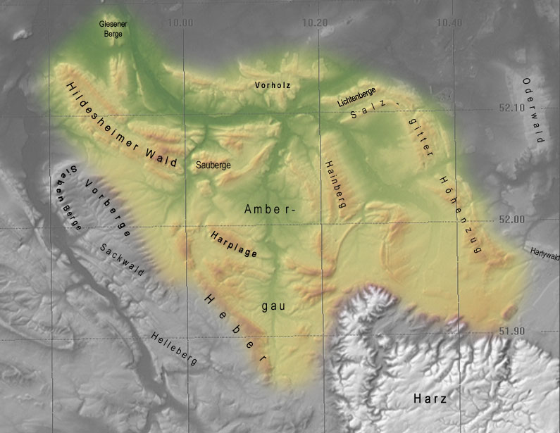
The Salzgitter Hills (german: Salzgitter-Höhenzug, also ''Salzgitterscher Höhenzug'') is an area of upland up to in height, in the Lower Saxon Hills between Salzgitter and Goslar in the districts of Wolfenbüttel and Goslar and in the territory of the independent town of Salzgitter. The hills lie in the German federal state of Lower Saxony. The German name of is a term used in the northern Harz Foreland, albeit not found on maps, and is used to mean the string of hills north of the Harz Mountains between the towns mentioned above. The state forest of the Salzgitter Hills is managed by several Lower Saxony forestry offices, including the in Salzgitter-Salder. The Salzgitter Hills can be divided into these four unnamed sections: * Northwest section (mainly comprising the Lichtenberge)(up to 254.2 m high; between Holle and Salzgitter-Gebhardshagen) * North-central section(up to 275.3 m high; between Salzgitter-Gebhardshagen and Salzgitter-Bad) * South-central sectio ... [...More Info...] [...Related Items...] OR: [Wikipedia] [Google] [Baidu] |
Innerstebergland
The Innerste Uplands (german: Innerstebergland) is a landscape region up to 359 m high and covering an area of over 900 km² in the northern part of the German Central Uplands. It lies within the eastern part of the Weser-Leine Uplands in Lower Saxony (Germany). The Innerste Uplands gets its name from the Innerste, a tributary of the River Leine. Geography Location The Innerste Uplands cover the catchment area of the Innerste southeast of Hildesheim and southwest to south of Salzgitter as far as Goslar and Seesen on the northwestern edge of the Harz. To the north the area is bounded by the Hildesheim Börde, to the west by the Leine Uplands and to the southeast by the North Harz Foreland. Its central and southern areas are dominated by the Ambergau, a depression dissected by the Nette, a tributary of the Innerste. In and around the Innerste Uplands there are the following clearly defined ridges, most of which are cuestas and some of which lie on the boundary wit ... [...More Info...] [...Related Items...] OR: [Wikipedia] [Google] [Baidu] |
Lichtenberg Castle (Salzgitter)
Lichtenberg Castle (german: Burg Lichtenberg), also called the Heinrichsburg ("Henry Castle"), is a ruined castle dating to the 12th century in the Lichtenberge hills (the northwestern part of the Salzgitter Hills) near Salzgitter in the German state of Lower Saxony. The ruins are found south of and above the Salzgitter suburb of Lichtenberg on the steep summit of the ''Burgberg'' (241 metres high). The site, which is extremely good from a strategic perspective, shows the ideal type of ground plan of a hill castle from the High Middle Ages. The builder of the most important fortifications of the Welf dynasty was Duke Henry the Lion. The castle was built to counter the Bishopric of Hildesheim and its Hohenstaufen neighbour in Goslar. In spite of numerous conflicts of those times, it was not destroyed until 1552 by the cannons of a mercenary army. Layout of the castle The castle comprises an upper and lower wards. The upper ward lies on an oval plateau, 45 metres × 80 met ... [...More Info...] [...Related Items...] OR: [Wikipedia] [Google] [Baidu] |
Haverlah
Haverlah is a municipality in the district of Wolfenbüttel, in Lower Saxony, Germany Germany,, officially the Federal Republic of Germany, is a country in Central Europe. It is the second most populous country in Europe after Russia, and the most populous member state of the European Union. Germany is situated betwe .... References Wolfenbüttel (district) {{Wolfenbüttel-geo-stub ... [...More Info...] [...Related Items...] OR: [Wikipedia] [Google] [Baidu] |
Elbe (Niedersachsen)
Elbe is a municipality in the district of Wolfenbüttel, in Lower Saxony, Germany Germany,, officially the Federal Republic of Germany, is a country in Central Europe. It is the second most populous country in Europe after Russia, and the most populous member state of the European Union. Germany is situated betwe .... References Wolfenbüttel (district) {{Wolfenbüttel-geo-stub ... [...More Info...] [...Related Items...] OR: [Wikipedia] [Google] [Baidu] |
Burgdorf (bei Salzgitter) (1895–1945), German general
{{disambiguation, geo, surname ...
Burgdorf may refer to: Places *Burgdorf, Switzerland, a town in the canton of Berne, Switzerland *Burgdorf district, a district in the canton of Berne, Switzerland *Burgdorf, Hanover, a town in the district of Hanover, Lower Saxony, Germany *Burgdorf, Wolfenbüttel, a municipality in the district of Wolfenbüttel, Lower Saxony, Germany *Burgdorf, Idaho, USA, rustic hot springs resort (since the 19th century), and alleged town People *Wilhelm Burgdorf Wilhelm Emanuel Burgdorf (15 February 1895 – 2 May 1945) was a German general during World War II, who served as a commander and staff officer in the German Army (Wehrmacht), German Army. In October 1944, Burgdorf assumed the role of the chief ... [...More Info...] [...Related Items...] OR: [Wikipedia] [Google] [Baidu] |
Baddeckenstedt
Baddeckenstedt is a municipality in the district of Wolfenbüttel, in Lower Saxony, Germany. It is situated in an exclave of the district, approx. 10 km southwest of Salzgitter, and 30 km southwest of Braunschweig. Baddeckenstedt is also the seat of the ''Samtgemeinde A ''Samtgemeinde'' (; plural: ''Samtgemeinden'') is a type of administrative division in Lower Saxony, Germany. ''Samtgemeinden'' are local government associations of municipality, municipalities, equivalent to the ''Amt (administrative division ...'' ("collective municipality") Baddeckenstedt. The municipality Baddeckenstedt consists of the following villages: # Baddeckenstedt # Binder # Oelber am weißen Wege # Rhene # Wartjenstedt References Wolfenbüttel (district) {{Wolfenbüttel-geo-stub ... [...More Info...] [...Related Items...] OR: [Wikipedia] [Google] [Baidu] |
Landkreis Hildesheim
Hildesheim is a district (''Landkreis'') in Lower Saxony, Germany. It is bounded by (from the north and clockwise) the districts of Hanover, Peine, Wolfenbüttel, Goslar, Northeim, Holzminden and Hamelin-Pyrmont. History In 1885 the Prussian government established districts within the Province of Hanover. The present territory of the district was occupied by four districts: Hildesheim, Alfeld, Gronau and Marienburg. In 1932 the district of Gronau joined Alfeld, and the number of districts was reduced to three. When the state of Lower Saxony was founded in 1946, the districts were reorganised: Hildesheim became an urban district, the remaining district of Hildesheim and Marienburg were merged to the new district of Hildesheim-Marienburg. The district of Alfeld remained in its former borders. In 1974 the city of Hildesheim lost its status as an urban district and became part of the surrounding district, which was renamed to Hildesheim. The districts of Hildesheim and Alfeld were m ... [...More Info...] [...Related Items...] OR: [Wikipedia] [Google] [Baidu] |
Burg Lichtenberg
The German word Burg means castle. Burg or Bürg may refer to: Places Placename element * ''-burg'', a combining form in Dutch, German and English placenames * Burg, a variant of burh, the fortified towns of Saxon England Settlements * Burg, Aargau, Switzerland * Burg, Bernkastel-Wittlich, Germany * Burg, Bitburg-Prüm, Germany * Burg, Brandenburg, Germany * Burg, Dithmarschen, Germany * Burg auf Fehmarn, Germany * Burg bei Magdeburg, Germany * Burg im Leimental, Switzerland * Den Burg, Netherlands * The Burg, Illinois, United States * Burg, Hautes-Pyrénées, France * Burg, Kilninian and Kilmore, a place on the Isle of Mull, Argyll and Bute, Scotland * Melber, Kentucky, United States, also known as Burg Other uses * Burg (surname) or Bürg * Bürg (crater) * Burg (ship, 2003), a car ferry operating on Switzerland's Lake Zurich *Burgs (fast-food chain) See also * * Burgh (other) * Borg (other) * Bourg (other) * Borough and -bury, common English v ... [...More Info...] [...Related Items...] OR: [Wikipedia] [Google] [Baidu] |
Warne (river)
Warne is a river of Lower Saxony, Germany. The Warne springs west of Liebenburg. It is a left tributary of the Oker at Dorstadt. See also *List of rivers of Lower Saxony All rivers in the German state of Lower Saxony flow directly or indirectly into the North Sea. A–Z A B D E F G H I J K L M N O P * Purrmühlenbach R S T * Tiefenbeek * Trillkebach * Trutenbeek * Twiste U * Uffe * Ulrich ... References Rivers of Lower Saxony Rivers of Germany {{LowerSaxony-river-stub ... [...More Info...] [...Related Items...] OR: [Wikipedia] [Google] [Baidu] |
Oker
The Oker is a river in Lower Saxony, Germany, that has historically formed an important political boundary. It is a left tributary of the River Aller, in length and runs in a generally northerly direction. Origin and meaning of the name The river's name was recorded around 830 as ''Obacra'' and, later, as ''Ovokare'' und ''Ovakara''.H. Blume: ''Oker, Schunter, Wabe.'' In: ''Braunschweigisches Jahrbuch für Landesgeschichte'', vol. 86, 2005, p. 14 sqq. The origin of the name is derived from the roots ''ov-'' and ''-akara'' meaning “upper” (cf. New High German ''ober-'') and “onward rushing” (rendered in German as “Vorwärtsdrängende”) as distinct from its tributary, the Ecker, whose name means only “onward rushing”. Course The Oker rises at about 910 metres in the Harz National Park in a boggy area on the Bruchberg in the Harz mountains of central Germany. This early section is known as the ''Große Oker'' ("Great Oker") and it is impounded below A ... [...More Info...] [...Related Items...] OR: [Wikipedia] [Google] [Baidu] |
Innerste
The Innerste is a river in Lower Saxony, Germany. It is a right tributary of the Leine river and in length. Origin of the name The river name is not related to the German word ''innerste'' meaning innermost. ''Innerste'', in earlier times called the ''Inste'' (1805), ''Inderste'' (1567), ''Indistria'' (1313), ''Entrista'' (1065) and ''Indrista'' (1013), probably goes back to the Indo-Germanic root ''oid'' = ''turbulent, strong''. It may be the name referred to in the name of the battlefield of '' ''Idista''viso'' (16 A.D.). Course The river's source is in the Harz mountains, from the town of Clausthal-Zellerfeld to the southwest at an elevation of 615 m and is called ''Innerstesprung''. As a small brook, the Innerste flows west and passes a system of lakes, the first of which is called ''Entensumpf''. The next lakes are ''Oberer Nassenwieser Teich'', ''Bärenbrucher Teich'', ''Ziegenberger Teich'', and ''Sumpfteich''. The German word ''Teich'' means "pond". Having ... [...More Info...] [...Related Items...] OR: [Wikipedia] [Google] [Baidu] |
Fuhse
The Fuhse is a river of Lower Saxony, Germany, a left tributary of the Aller. Spelled Fuse in maps of the 19th century and earlier, the name is thought to derive from the ancient Fosa flumen, after which the Germanic tribe of the Fosi took their name (or vice versa). The Fuhse originates on the west slope of the Oderwald, foothills of the Harz range between Bad Harzburg und Wolfenbüttel. The source spring lies in the municipality of Flöthe near Schladen. From there the Fuhse flows west of Salzgitter. It turns to the north and flows through Peine, Dollbergen and Uetze to Celle. In Celle (borough Neustadt) it joins the Aller. The most important tributary is the , that joins the Fuhse at Uetze. See also *List of rivers of Lower Saxony All rivers in the German state of Lower Saxony flow directly or indirectly into the North Sea. A–Z A B D E F G H I J K L M N O P * Purrmühlenbach R S T *Tiefenbeek *Trillkebach *Trutenbeek * Twiste U * Uffe *Ulrichswas ... [...More Info...] [...Related Items...] OR: [Wikipedia] [Google] [Baidu] |


