|
Space Modulation
{{Modulation techniques Space modulation is a radio amplitude modulation technique used in instrument landing systems (ILS) that incorporates the use of multiple antennas fed with various radio frequency powers and phases to create different depths of modulation within various volumes of three-dimensional airspace. This modulation method differs from internal modulation methods inside most other radio transmitters in that the phases and powers of the two individual signals mix within airspace, rather than in a modulator. An aircraft with an on-board ILS receiver within the capture area of an ILS, (glideslope and localizer range), will detect varying depths of modulation according to the aircraft's position within that airspace, providing accurate positional information about the progress to the threshold. Method used to determine aircraft position The ILS uses two radio frequencies, one for each ground station (about 110 MHz for LOC and 330 MHz for the GS), to transmit ... [...More Info...] [...Related Items...] OR: [Wikipedia] [Google] [Baidu] |
Amplitude Modulation
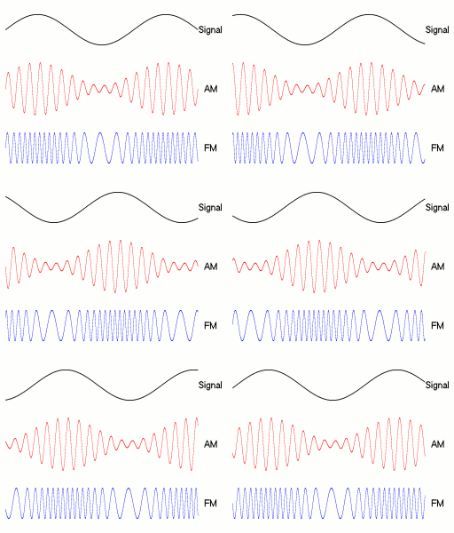
Amplitude modulation (AM) is a modulation technique used in electronic communication, most commonly for transmitting messages with a radio wave. In amplitude modulation, the amplitude (signal strength) of the wave is varied in proportion to that of the message signal, such as an audio signal. This technique contrasts with angle modulation, in which either the frequency of the carrier wave is varied, as in frequency modulation, or its phase, as in phase modulation. AM was the earliest modulation method used for transmitting audio in radio broadcasting. It was developed during the first quarter of the 20th century beginning with Roberto Landell de Moura and Reginald Fessenden's radiotelephone experiments in 1900. This original form of AM is sometimes called double-sideband amplitude modulation (DSBAM), because the standard method produces sidebands on either side of the carrier frequency. Single-sideband modulation uses bandpass filters to eliminate one of the sidebands ... [...More Info...] [...Related Items...] OR: [Wikipedia] [Google] [Baidu] |
Instrument Landing System
In aviation, the instrument landing system (ILS) is a precision radio navigation system that provides short-range guidance to aircraft to allow them to approach a runway at night or in bad weather. In its original form, it allows an aircraft to approach until it is over the ground, within a of the runway. At that point the runway should be visible to the pilot; if it is not, they perform a missed approach. Bringing the aircraft this close to the runway dramatically increases the range of weather conditions in which a safe landing can be made. Other versions of the system, or "categories", have further reduced the minimum altitudes, runway visual ranges (RVRs), and transmitter and monitoring configurations designed depending on the normal expected weather patterns and airport safety requirements. ILS uses two directional radio signals, the ''localizer'' (108 to 112 MHz frequency), which provides horizontal guidance, and the ''glideslope'' (329.15 to 335 MHz frequen ... [...More Info...] [...Related Items...] OR: [Wikipedia] [Google] [Baidu] |
Three-dimensional Space
Three-dimensional space (also: 3D space, 3-space or, rarely, tri-dimensional space) is a geometric setting in which three values (called ''parameters'') are required to determine the position of an element (i.e., point). This is the informal meaning of the term dimension. In mathematics, a tuple of numbers can be understood as the Cartesian coordinates of a location in a -dimensional Euclidean space. The set of these -tuples is commonly denoted \R^n, and can be identified to the -dimensional Euclidean space. When , this space is called three-dimensional Euclidean space (or simply Euclidean space when the context is clear). It serves as a model of the physical universe (when relativity theory is not considered), in which all known matter exists. While this space remains the most compelling and useful way to model the world as it is experienced, it is only one example of a large variety of spaces in three dimensions called 3-manifolds. In this classical example, when the ... [...More Info...] [...Related Items...] OR: [Wikipedia] [Google] [Baidu] |
Glidepath
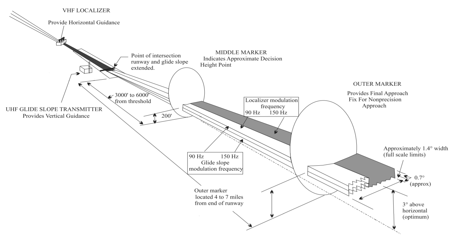
Instrument landing system glide path, commonly referred to as a glide path (G/P) or glide slope (G/S), is "a system of vertical guidance embodied in the instrument landing system which indicates the vertical deviation of the aircraft from its optimum path of descent", according to ''Article 1.106'' of the ITU Radio Regulations (ITU RR).ITU Radio Regulations, Section IV. Radio Stations and Systems – Article 1.106, definition: ''instrument landing system (ILS)'' Principle of operation A glide slope station uses an antenna array sited to one side of the runway touchdown zone. The GS signal is transmitted on a carrier signal using a technique similar to that for the localizer. The centre of the glide slope signal is arranged to define a glide path of approximately 3° above horizontal (ground level). The beam is 1.4° deep (0.7° below the glide-path centre and 0.7° above). The pilot (or the autopilot, if using autoland) controls the aircraft so that the glide slope indicator r ... [...More Info...] [...Related Items...] OR: [Wikipedia] [Google] [Baidu] |
Airspace
Airspace is the portion of the atmosphere controlled by a country above its territory, including its territorial waters or, more generally, any specific three-dimensional portion of the atmosphere. It is not the same as aerospace, which is the general term for Earth's atmosphere and the outer space in its vicinity. Within the United States: * Controlled airspace exists where it is deemed necessary that air traffic control has some form of positive executive control over aircraft flying in that airspace (however, air traffic control does not necessarily control traffic operating under visual flight rules (VFR) within this airspace). Airspace may be further subdivided into a variety of areas and zones, including those where there are either restrictions on flying activities or complete prohibition of flying activities. Horizontal boundary By international law, a state "has complete and exclusive sovereignty over the airspace above its territory", which corresponds with ... [...More Info...] [...Related Items...] OR: [Wikipedia] [Google] [Baidu] |
Instrument Landing System
In aviation, the instrument landing system (ILS) is a precision radio navigation system that provides short-range guidance to aircraft to allow them to approach a runway at night or in bad weather. In its original form, it allows an aircraft to approach until it is over the ground, within a of the runway. At that point the runway should be visible to the pilot; if it is not, they perform a missed approach. Bringing the aircraft this close to the runway dramatically increases the range of weather conditions in which a safe landing can be made. Other versions of the system, or "categories", have further reduced the minimum altitudes, runway visual ranges (RVRs), and transmitter and monitoring configurations designed depending on the normal expected weather patterns and airport safety requirements. ILS uses two directional radio signals, the ''localizer'' (108 to 112 MHz frequency), which provides horizontal guidance, and the ''glideslope'' (329.15 to 335 MHz frequen ... [...More Info...] [...Related Items...] OR: [Wikipedia] [Google] [Baidu] |


.png)
.jpg)