|
South Boulder Creek (Colorado)
South Boulder Creek is a tributary of Boulder Creek in central Colorado in the United States. Its source is near Rogers Pass on the Continental Divide. The stream flows to a confluence with Boulder Creek in northeast Boulder. Gross Dam is located on South Boulder Creek, approximately miles west of Eldorado Springs, Colorado. See also * List of rivers of Colorado This is a list of streams in the U.S. State of Colorado. __TOC__ Alphabetical list The following alphabetical list includes many important streams that flow through the State of Colorado, including all 158 named rivers. Where available, t ... References External links Rivers of Colorado Rivers of Boulder County, Colorado Rivers of Gilpin County, Colorado {{Colorado-river-stub ... [...More Info...] [...Related Items...] OR: [Wikipedia] [Google] [Baidu] |
Eldorado Canyon State Park
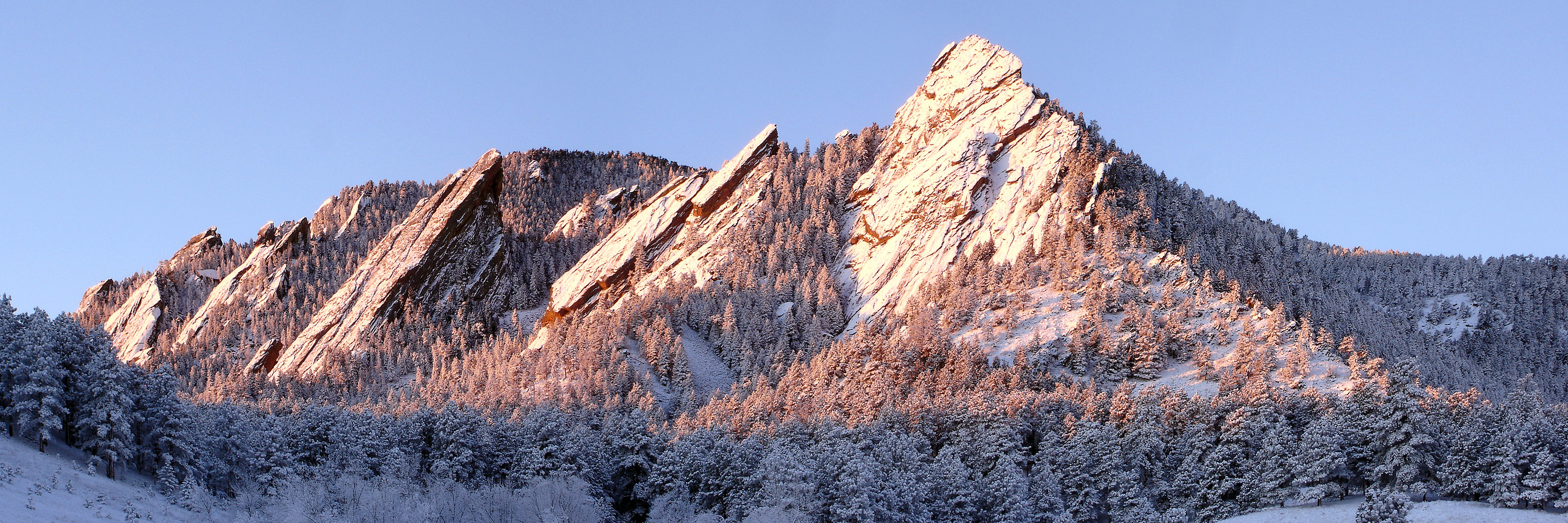
Eldorado Canyon State Park is part of the Colorado State Park system. It was established in 1978 and is located in Boulder County near the city of Boulder. The park consists of two areas, the Inner Canyon (developed area) and Crescent Meadows (undeveloped area). The park encompasses with a variety of recreation opportunities available. Eldorado Canyon is home to one of the world's most accessible and comprehensive rock climbing areas. This state park is open during daylight hours only, visitors are expected to leave before dusk. History Ute Indians were the first inhabitants into this area that is nestled against the foothills near Boulder. The Indians lived within the walls of the canyon because they provided protection from the harsh Colorado winters. Settlers soon followed in search of gold and agriculture. Eldorado Canyon is known for its geologic history dating back billions of years. Near the park’s entrance at the visitors center, there are rocks calculated to be over 1 ... [...More Info...] [...Related Items...] OR: [Wikipedia] [Google] [Baidu] |
Gilpin County, Colorado
Gilpin County is a county located in the U.S. state of Colorado, smallest in land area behind only the City and County of Broomfield. As of the 2020 census, the population was 5,808. The county seat is Central City. The county was formed in 1861, while Colorado was still a Territory, and was named after Colonel William Gilpin, the first territorial governor. Gilpin County is part of the Denver-Aurora- Lakewood, CO Metropolitan Statistical Area. Geography According to the U.S. Census Bureau, the county has a total area of , of which is land and (0.2%) is water. It is the second-smallest county by area in Colorado. Adjacent counties * Boulder County – north * Jefferson County – east * Clear Creek County – south * Grand County – west Major Highways * State Highway 46 * State Highway 72 * State Highway 119 * Central City Parkway National protected areas * Arapaho National Forest *James Peak Wilderness *Roosevelt National Forest State protected area *Gold ... [...More Info...] [...Related Items...] OR: [Wikipedia] [Google] [Baidu] |
Boulder Creek (Colorado)
Boulder Creek is a U.S. Geological Survey. National Hydrography Dataset high-resolution flowline dataThe National Map, accessed March 25, 2011 creek draining the Rocky Mountains to the west of Boulder, Colorado, as well as the city itself and surrounding plains. Route The creek is formed by two main tributaries rising along the Continental Divide: North and Middle Boulder Creek; and later joined by South Boulder Creek. North Boulder Creek forms in a valley between Navajo Peak and Arikaree Peak on the Continental Divide, in the Green Lakes chain of lakes. The creek flows past the community of Switzerland Park to join Middle Boulder Creek. Middle Boulder Creek rises as two forks from the Continental Divide: the North Fork rises in a cirque below Mount Neva and flows to the South Fork. The South Fork rises at Rollins Pass on the Continental Divide and flows to the North Fork. From the junction of the two forks, Middle Boulder Creek, long, flows east through the towns of ... [...More Info...] [...Related Items...] OR: [Wikipedia] [Google] [Baidu] |
South Platte River
The South Platte River is one of the two principal tributaries of the Platte River. Flowing through the U.S. states of Colorado and Nebraska, it is itself a major river of the American Midwestern United States, Midwest and the American Southwestern United States, Southwest/Mountain States, Mountain West. Its drainage basin includes much of the eastern flank of the Rocky Mountains in Colorado, much of the populated region known as the Colorado Front Range and Colorado Eastern Plains, Eastern Plains, and a portion of southeastern Wyoming in the vicinity of the city of Cheyenne, Wyoming, Cheyenne. It joins the North Platte River in western Nebraska to form the Platte, which then flows across Nebraska to the Missouri River, Missouri. The river serves as the principal source of water for eastern Colorado. In its valley along the foothills in Colorado, it has permitted agriculture in an area of the Colorado Piedmont and Great Plains that is otherwise arid. Description The river ... [...More Info...] [...Related Items...] OR: [Wikipedia] [Google] [Baidu] |
Platte River
The Platte River () is a major river in the State of Nebraska. It is about long; measured to its farthest source via its tributary, the North Platte River, it flows for over . The Platte River is a tributary of the Missouri River, which itself is a tributary of the Mississippi River which flows to the Gulf of Mexico. The Platte over most of its length is a broad, shallow, meandering stream with a sandy bottom and many islands—a braided stream. The Platte is one of the most significant tributary systems in the watershed of the Missouri, draining a large portion of the central Great Plains in Nebraska and the eastern Rocky Mountains in Colorado and Wyoming. The river valley played an important role in the westward expansion of the United States, providing the route for several major emigrant trails, including the Oregon, California, Mormon and Bozeman trails. The first Europeans to see the Platte were French explorers and fur trappers about 1714; they first called it the '' ... [...More Info...] [...Related Items...] OR: [Wikipedia] [Google] [Baidu] |
Mississippi River
The Mississippi River is the second-longest river and chief river of the second-largest drainage system in North America, second only to the Hudson Bay drainage system. From its traditional source of Lake Itasca in northern Minnesota, it flows generally south for to the Mississippi River Delta in the Gulf of Mexico. With its many tributaries, the Mississippi's watershed drains all or parts of 32 U.S. states and two Canadian provinces between the Rocky and Appalachian mountains. The main stem is entirely within the United States; the total drainage basin is , of which only about one percent is in Canada. The Mississippi ranks as the thirteenth-largest river by discharge in the world. The river either borders or passes through the states of Minnesota, Wisconsin, Iowa, Illinois, Missouri, Kentucky, Tennessee, Arkansas, Mississippi, and Louisiana. Native Americans have lived along the Mississippi River and its tributaries for thousands of years. Most were hunter-ga ... [...More Info...] [...Related Items...] OR: [Wikipedia] [Google] [Baidu] |
Colorado
Colorado (, other variants) is a state in the Mountain West subregion of the Western United States. It encompasses most of the Southern Rocky Mountains, as well as the northeastern portion of the Colorado Plateau and the western edge of the Great Plains. Colorado is the eighth most extensive and 21st most populous U.S. state. The 2020 United States census enumerated the population of Colorado at 5,773,714, an increase of 14.80% since the 2010 United States census. The region has been inhabited by Native Americans and their ancestors for at least 13,500 years and possibly much longer. The eastern edge of the Rocky Mountains was a major migration route for early peoples who spread throughout the Americas. "''Colorado''" is the Spanish adjective meaning "ruddy", the color of the Fountain Formation outcroppings found up and down the Front Range of the Rocky Mountains. The Territory of Colorado was organized on February 28, 1861, and on August 1, 1876, U.S. President Ulyss ... [...More Info...] [...Related Items...] OR: [Wikipedia] [Google] [Baidu] |
United States
The United States of America (U.S.A. or USA), commonly known as the United States (U.S. or US) or America, is a country primarily located in North America. It consists of 50 states, a federal district, five major unincorporated territories, nine Minor Outlying Islands, and 326 Indian reservations. The United States is also in free association with three Pacific Island sovereign states: the Federated States of Micronesia, the Marshall Islands, and the Republic of Palau. It is the world's third-largest country by both land and total area. It shares land borders with Canada to its north and with Mexico to its south and has maritime borders with the Bahamas, Cuba, Russia, and other nations. With a population of over 333 million, it is the most populous country in the Americas and the third most populous in the world. The national capital of the United States is Washington, D.C. and its most populous city and principal financial center is New York City. Paleo-Americ ... [...More Info...] [...Related Items...] OR: [Wikipedia] [Google] [Baidu] |
Rogers Pass (Colorado)
Rogers Pass, elevation , is a mountain pass in the Front Range of central Colorado. The pass crosses the continental divide in the James Peak Wilderness The James Peak Wilderness is a U.S. Wilderness Area in north central Colorado in the Arapaho and Roosevelt national forests. The wilderness area borders Indian Peaks Wilderness to the north and the James Peak Protection Area to the west. Geograp .... References Landforms of Boulder County, Colorado Landforms of Grand County, Colorado Mountain passes of Colorado Great Divide of North America {{Colorado-geo-stub ... [...More Info...] [...Related Items...] OR: [Wikipedia] [Google] [Baidu] |
Boulder, Colorado
Boulder is a home rule city that is the county seat and most populous municipality of Boulder County, Colorado, United States. The city population was 108,250 at the 2020 United States census, making it the 12th most populous city in Colorado. Boulder is the principal city of the Boulder, CO Metropolitan Statistical Area and an important part of the Front Range Urban Corridor. Boulder is located at the base of the foothills of the Rocky Mountains, at an elevation of above sea level. Boulder is northwest of the Colorado state capital of Denver. It is home of the main campus of the University of Colorado, the state's largest university. History On November 7, 1861, the Colorado General Assembly passed legislation to locate the University of Colorado in Boulder. On September 20, 1875, the first cornerstone was laid for the first building (Old Main) on the CU campus. The university officially opened on September 5, 1877. In 1907, Boulder adopted an anti- saloon ordinanc ... [...More Info...] [...Related Items...] OR: [Wikipedia] [Google] [Baidu] |
List Of Rivers Of Colorado
This is a list of streams in the U.S. State of Colorado. __TOC__ Alphabetical list The following alphabetical list includes many important streams that flow through the State of Colorado, including all 158 named rivers. Where available, the total extent of the stream's drainage basin is shown after the name. The names of the 17 Colorado rivers with a drainage basin of more than 10,000 square kilometers (3,900 sq mi), about three times the area of Rhode Island, are shown in bold. # Adams Fork Conejos River # Alamosa River 383 km2 (148 mi2) # Animas River 3,562 km2 (1,375 mi2) # Apishapa River 2,798 km2 (1,080 mi2) #Arikaree River 4,429 km2 (1,710 mi2) # Arkansas River 478,501 km2 (184,750 mi2) # Aspen Brook # Bear Creek 4,500 km2 (1,737 mi2) # Bear Creek 339 km2 (131 mi2) # Bear River # Beaver Creek 2,939 km2 (1,135 mi2) #Big Dry Creek (Littleton, Colorado) #Big Dry Creek (Westminster, Colorado ... [...More Info...] [...Related Items...] OR: [Wikipedia] [Google] [Baidu] |


