|
Soundane
Soundane is a small village located in western Maharashtra in India. Taluka place for the village is Mohol. Post office for Soundane is located in a nearby villagTambole (Pin 413213) Soundane is part of the Solapur District. Location Soundane is located approximately 15 km from Mohol. Soundane can be reached from Mohol via another nearby village, Tambole. The entire road is a tar road and thus helps reach Soundane on any vehicle without limitations of travel on a rough road. Mohol itself is located on National Highway 65 and is separated from the district place, Solapur by approximately 35 km. Mohol is also the nearest train station for Soundane. One can also reach Soundane from Varakute, a nearby village located on Solapur - Pandharpur State Highway. This route passes via villages Kurul and Ankoli and is the alternate way to reach Soundane apart from connectivity via the Taluka place Mohol. Demographics Population {{cite web , url=http://www.censusindi ... [...More Info...] [...Related Items...] OR: [Wikipedia] [Google] [Baidu] |
States And Territories Of India
India is a federal union comprising 28 states and 8 union territories, with a total of 36 entities. The states and union territories are further subdivided into districts and smaller administrative divisions. History Pre-independence The Indian subcontinent has been ruled by many different ethnic groups throughout its history, each instituting their own policies of administrative division in the region. The British Raj mostly retained the administrative structure of the preceding Mughal Empire. India was divided into provinces (also called Presidencies), directly governed by the British, and princely states, which were nominally controlled by a local prince or raja loyal to the British Empire, which held ''de facto'' sovereignty ( suzerainty) over the princely states. 1947–1950 Between 1947 and 1950 the territories of the princely states were politically integrated into the Indian union. Most were merged into existing provinces; others were organised into ... [...More Info...] [...Related Items...] OR: [Wikipedia] [Google] [Baidu] |
Sugarcane
Sugarcane or sugar cane is a species of (often hybrid) tall, Perennial plant, perennial grass (in the genus ''Saccharum'', tribe Andropogoneae) that is used for sugar Sugar industry, production. The plants are 2–6 m (6–20 ft) tall with stout, jointed, fibrous stalks that are rich in sucrose, which accumulates in the Plant stem, stalk internodes. Sugarcanes belong to the grass family, Poaceae, an economically important flowering plant family that includes maize, wheat, rice, and sorghum, and many forage crops. It is native to the warm temperate and tropical regions of India, Southeast Asia, and New Guinea. The plant is also grown for biofuel production, especially in Brazil, as the canes can be used directly to produce ethyl alcohol (ethanol). Grown in tropical and subtropical regions, sugarcane is the world's largest crop by production quantity, totaling 1.9 billion tonnes in 2020, with Brazil accounting for 40% of the world total. Sugarcane accounts for 79% of sug ... [...More Info...] [...Related Items...] OR: [Wikipedia] [Google] [Baidu] |
Indian Sub-continent
The Indian subcontinent is a physiographical region in Southern Asia. It is situated on the Indian Plate, projecting southwards into the Indian Ocean from the Himalayas. Geopolitically, it includes the countries of Bangladesh, Bhutan, India, Maldives, Nepal, Pakistan, and Sri Lanka."Indian subcontinent". ''New Oxford Dictionary of English'' () New York: Oxford University Press, 2001; p. 929: "the part of Asia south of the Himalayas which forms a peninsula extending into the Indian Ocean, between the Arabian Sea and the Bay of Bengal. Historically forming the whole territory of Greater India, the region is now divided into three countries named Bangladesh, India and Pakistan." The terms ''Indian subcontinent'' and ''South Asia'' are often used interchangeably to denote the region, although the geopolitical term of South Asia frequently includes Afghanistan, which may otherwise be classified as Central Asian.John McLeod, The history of India', page 1, Greenwood Publishing Group ... [...More Info...] [...Related Items...] OR: [Wikipedia] [Google] [Baidu] |
Water Scarcity
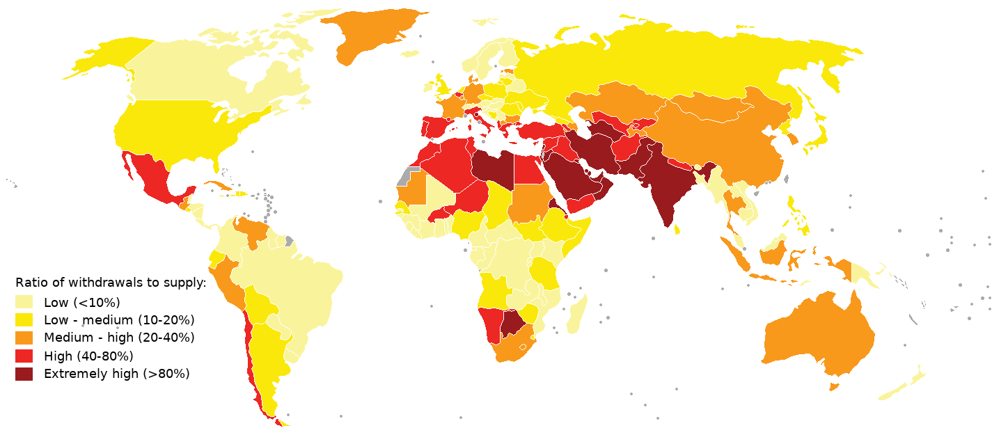
Water scarcity (closely related to water stress or water crisis) is the lack of fresh water Water resources, resources to meet the standard water demand. There are two types of water scarcity: physical or economic water scarcity. Physical water scarcity is where there is not enough water to meet all demands, including that needed for ecosystems to function effectively. Desert climate, Arid areas for example Central and West Asia, and North Africa often suffer from physical water scarcity. On the other hand, economic water scarcity is caused by a lack of investment in infrastructure or technology to draw water from rivers, aquifers, or other water sources, or insufficient human capacity to satisfy the demand for water. Much of Sub-Saharan Africa has economic water scarcity. The essence of global water scarcity is the geographic and temporal mismatch between fresh water demand and availability. At the global level and on an annual basis, enough freshwater is available to meet such ... [...More Info...] [...Related Items...] OR: [Wikipedia] [Google] [Baidu] |
Drought
A drought is defined as drier than normal conditions.Douville, H., K. Raghavan, J. Renwick, R.P. Allan, P.A. Arias, M. Barlow, R. Cerezo-Mota, A. Cherchi, T.Y. Gan, J. Gergis, D. Jiang, A. Khan, W. Pokam Mba, D. Rosenfeld, J. Tierney, and O. Zolina, 2021Water Cycle Changes In Climate Change 2021: The Physical Science Basis. Contribution of Working Group I to the Sixth Assessment Report of the Intergovernmental Panel on Climate Change [Masson-Delmotte, V., P. Zhai, A. Pirani, S.L. Connors, C. Péan, S. Berger, N. Caud, Y. Chen, L. Goldfarb, M.I. Gomis, M. Huang, K. Leitzell, E. Lonnoy, J.B.R. Matthews, T.K. Maycock, T. Waterfield, O. Yelekçi, R. Yu, and B. Zhou (eds.)]. Cambridge University Press, Cambridge, United Kingdom and New York, NY, USA, pp. 1055–1210, doi:10.1017/9781009157896.010. This means that a drought is "a moisture deficit relative to the average water availability at a given location and season". A drought can last for days, months or years. Drought ... [...More Info...] [...Related Items...] OR: [Wikipedia] [Google] [Baidu] |
Dryland Farming
Dryland farming and dry farming encompass specific agricultural techniques for the non-irrigated cultivation of crops. Dryland farming is associated with drylands, areas characterized by a cool wet season (which charges the soil with virtually all the moisture that the crops will receive prior to harvest) followed by a warm dry season. They are also associated with arid conditions, areas prone to drought and those having scarce water resources. Process Dryland farming has evolved as a set of techniques and management practices used by farmers to continually adapt to the presence or lack of moisture in a given crop cycle. In marginal regions, a farmer should be financially able to survive occasional crop failures, perhaps for several years in succession. Survival as a dryland farmer requires careful husbandry of the moisture available for the crop and aggressive management of expenses to minimize losses in poor years. Dryland farming involves the constant assessing of the amo ... [...More Info...] [...Related Items...] OR: [Wikipedia] [Google] [Baidu] |
Ujani Dam
Ujjani Dam, also known as Bhima Dam or Bhima Irrigation Project, on the Bhima River, a tributary of the Krishna River, is an dam#Earth-fill dams, earthfill cum Gravity dam, Masonry gravity dam located near Ujjani village of Madha Taluk in Solapur district of the state of Maharashtra in India. The Bhima River, which originates in Bhimashankar of the Western Ghats, and forms the Bhima Valley with its tributary rivers and streams, has twenty-two dams built on it of which the Ujjani Dam is the terminal dam on the river and is the largest in the valley that intercepts a catchment area of (which includes a free catchment of ). The construction of the dam project including the canal system on both banks was started in 1969 at an initial estimated cost of rupee, Rs 400 million and when completed in June 1980 the cost incurred was of the order of Rs 3295.85 million. The reservoir created by the high earth cum concrete gravity dam on the Bhima River has a gross storage capacity of . The ... [...More Info...] [...Related Items...] OR: [Wikipedia] [Google] [Baidu] |
Canal
Canals or artificial waterways are waterways or engineered channels built for drainage management (e.g. flood control and irrigation) or for conveyancing water transport vehicles (e.g. water taxi). They carry free, calm surface flow under atmospheric pressure, and can be thought of as artificial rivers. In most cases, a canal has a series of dams and locks that create reservoirs of low speed current flow. These reservoirs are referred to as ''slack water levels'', often just called ''levels''. A canal can be called a ''navigation canal'' when it parallels a natural river and shares part of the latter's discharges and drainage basin, and leverages its resources by building dams and locks to increase and lengthen its stretches of slack water levels while staying in its valley. A canal can cut across a drainage divide atop a ridge, generally requiring an external water source above the highest elevation. The best-known example of such a canal is the Panama Canal. Many ... [...More Info...] [...Related Items...] OR: [Wikipedia] [Google] [Baidu] |


