|
Somerville, New Brunswick
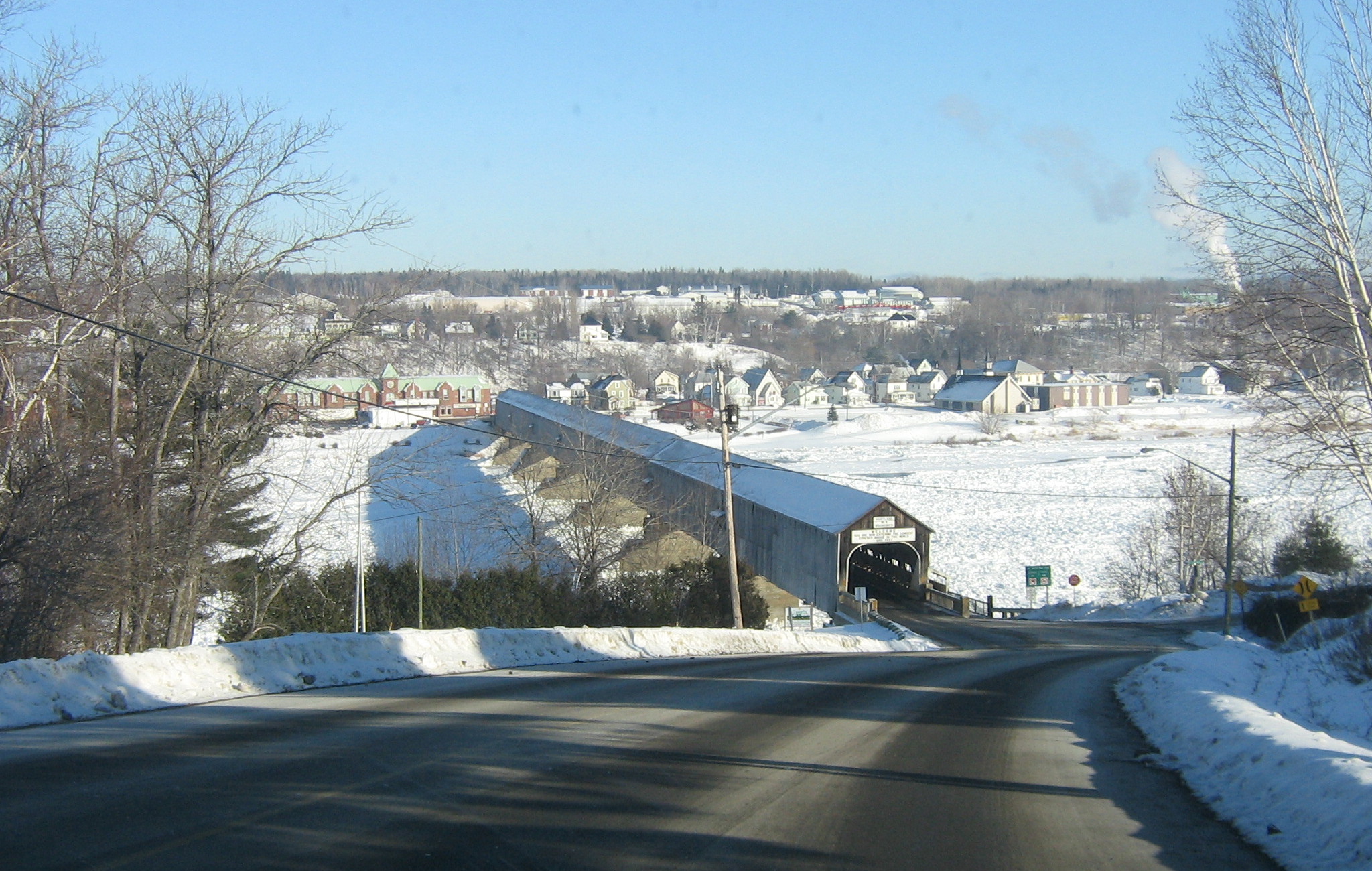
Somerville (2016 pop.: 286) is a Canadian rural community in Carleton County, New Brunswick. Somerville is located on Route 103 between Wakefield and Hartland. The Hartland Bridge, the longest covered bridge A covered bridge is a timber-truss bridge with a roof, decking, and siding, which in most covered bridges create an almost complete enclosure. The purpose of the covering is to protect the wooden structural members from the weather. Uncovered woo ... in the world, crosses the Saint John River between Hartland and Somerville. History Notable people See also * List of communities in New Brunswick References Communities in Carleton County, New Brunswick Designated places in New Brunswick {{NewBrunswick-geo-stub ... [...More Info...] [...Related Items...] OR: [Wikipedia] [Google] [Baidu] |
Carleton County, New Brunswick
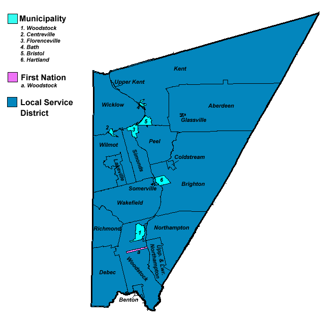
Carleton County (2016 population 26,220) is located in west-central New Brunswick, Canada. The western border is Aroostook County, Maine, Aroostook County, Maine, the northern border is Victoria County, New Brunswick, Victoria County, and the southeastern border is York County, New Brunswick, York County from which it was formed in 1831. The Saint John River (New Brunswick), Saint John River bisects the western section of the county. The Southwest Miramichi River flows through the eastern section of the county. Potato farming is a major industry. The scenic town of Hartland, New Brunswick, Hartland is home to the longest covered bridge in the world. Transportation Major Highways * * * * * * * * * * * * * * * * * * * * Census subdivisions List of communities in New Brunswick, Communities There are five incorporated municipalities within Carleton County (listed by 2016 population): First Nations There is one First Nations reserve in Carleton County, the Woodstock_First_Na ... [...More Info...] [...Related Items...] OR: [Wikipedia] [Google] [Baidu] |
New Brunswick
New Brunswick (french: Nouveau-Brunswick, , locally ) is one of the thirteen provinces and territories of Canada. It is one of the three Maritime provinces and one of the four Atlantic provinces. It is the only province with both English and French as its official languages. New Brunswick is bordered by Quebec to the north, Nova Scotia to the east, the Gulf of Saint Lawrence to the northeast, the Bay of Fundy to the southeast, and the U.S. state of Maine to the west. New Brunswick is about 83% forested and its northern half is occupied by the Appalachians. The province's climate is continental with snowy winters and temperate summers. New Brunswick has a surface area of and 775,610 inhabitants (2021 census). Atypically for Canada, only about half of the population lives in urban areas. New Brunswick's largest cities are Moncton and Saint John, while its capital is Fredericton. In 1969, New Brunswick passed the Official Languages Act which began recognizing French as an ... [...More Info...] [...Related Items...] OR: [Wikipedia] [Google] [Baidu] |
New Brunswick Route 103
Route 103 is a highway in New Brunswick, Canada, running from Woodstock to Florenceville along the west bank of the Saint John River, a distance of 42 kilometres. Route 103 begins at the interchange between the Trans-Canada Highway and Route 555 and passes the eastern terminus of Route 95, where it connects the interchange to downtown Woodstock and Interstate 95 via the Houlton Road. The route turns north along Main Street, following the Saint John River bank. At Somerville, a feeder road off Route 103 leads to the longest covered bridge in the world, connecting to the town of Hartland. The route ends at an intersection with Route 110 in Florenceville. Until 2003, Route 103 began south of Woodstock at a former Trans-Canada intersection at Bulls Creek, but with a new twinned section of the highway opening and a small part of Route 2 being abandoned, Route 103 was shortened to end in Woodstock. A new highway, Route 165, now uses the former Trans-Canada from Lakeland Ridges ... [...More Info...] [...Related Items...] OR: [Wikipedia] [Google] [Baidu] |
Wakefield, New Brunswick
Wakefield is in Wakefield parish in Carleton County, New Brunswick. Wakefield is located on Route 103 between Somerville, Richmond, Woodstock, Brighton, Simonds, Wilmot, Lakeville, Hartland, and Maine. The Hartland Bridge, the longest covered bridge in the world, is located in nearby Hartland on the Saint John River. History Notable people See also *List of communities in New Brunswick This is a list of communities in New Brunswick, a province in Canada. For the purposes of this list, a community is defined as either an incorporated municipality, an Indian reserve, or an unincorporated community inside or outside a municipalit ... References Communities in Carleton County, New Brunswick {{NewBrunswick-geo-stub ... [...More Info...] [...Related Items...] OR: [Wikipedia] [Google] [Baidu] |
Hartland, New Brunswick
Hartland is a town in Carleton County, New Brunswick, Carleton County, New Brunswick, Canada. On 1 January 2023, Hartland annexed all or part of seven Local service district (New Brunswick), local service districts, greatly expanding its area and population. The community's name remains in official use. Revised census figures have not been released. Geography Hartland is situated on the Saint John River (New Brunswick), Saint John River in the central-western portion of the province in the agricultural heartland of Carleton County. History The first settler in the area of what would become Hartland was William Orser (b.1762) and his son William Jr. William traveled there from New York (state), New York with his wife and six children. His wife died of an illness and he remarried to a widow, Mary Blake, who also had six children. The pair later conceived an additional six children. The land was settled in 1797, and granted in 1809. The town was named Hartland in 1874, to honou ... [...More Info...] [...Related Items...] OR: [Wikipedia] [Google] [Baidu] |
Hartland Bridge
The Hartland Covered Bridge in Hartland, New Brunswick, is the world's longest covered bridge, at long. It crosses the Saint John River from Hartland to Somerville, New Brunswick, Canada. The framework consists of seven small Howe Truss bridges joined on six piers. History Before the bridge, the only way to cross the Saint John River was by ferry. Plans and specifications of the bridge began in 1898 and the bridge was constructed in 1901 by the Hartland Bridge Company. On May 13, 1901, Dr. Estey was the first person to cross the bridge before its scheduled opening, because he had to respond to an emergency call. Workers placed planks on the bridge so he could drive across the bridge. It was finally inaugurated by Justice McKeowan on July 4, 1901, before a crowd of 2,000 people. It was funded by tolls until it was purchased by the provincial government on May 1, 1906. The bridge was not originally built covered. A fire in 1907 burnt some of the structure and nearly destr ... [...More Info...] [...Related Items...] OR: [Wikipedia] [Google] [Baidu] |
Covered Bridge
A covered bridge is a timber-truss bridge with a roof, decking, and siding, which in most covered bridges create an almost complete enclosure. The purpose of the covering is to protect the wooden structural members from the weather. Uncovered wooden bridges typically have a lifespan of only 20 years because of the effects of rain and sun, but a covered bridge could last over 100 years. In the United States, only about 1 in 10 survived the 20th century. The relatively small number of surviving bridges is due to deliberate replacement, neglect, and the high cost of restoration. European and North American truss bridges Typically, covered bridges are structures with longitudinal timber-trusses which form the bridge's backbone. Some were built as railway bridges, using very heavy timbers and doubled up lattice work. In Canada and the U.S., numerous timber covered bridges were built in the late 1700s to the late 1800s, reminiscent of earlier designs in Germany and Switzerland. Th ... [...More Info...] [...Related Items...] OR: [Wikipedia] [Google] [Baidu] |
Saint John River (New Brunswick)
The Saint John River (french: Fleuve Saint-Jean; Maliseet-Passamaquoddy: ''Wolastoq'') is a long river that flows from Northern Maine into Canada, and runs south along the western side of New Brunswick, emptying into the Atlantic Ocean in the Bay of Fundy. Eastern Canada's longest river, its drainage basin is one of the largest on the east coast at about . A part of the border between New Brunswick and Maine follows 130 km (80 miles) of the river. A tributary forms 55 km (35 miles) of the border between Quebec and Maine. New Brunswick settlements through which it passes include, moving downstream, Edmundston, Fredericton, Oromocto, and Saint John. It is regulated by hydro-power dams at Mactaquac, Beechwood, and Grand Falls, New Brunswick. Hydronym Samuel de Champlain visited the mouth of the river on the feast day of John the Baptist in 1604 and renamed it the Rivière Saint-Jean or Saint John River in English. Many waterways in the system retain their origi ... [...More Info...] [...Related Items...] OR: [Wikipedia] [Google] [Baidu] |
List Of Communities In New Brunswick
This is a list of communities in New Brunswick, a province in Canada. For the purposes of this list, a community is defined as either an incorporated municipality, an Indian reserve, or an unincorporated community inside or outside a municipality. Cities New Brunswick has eight cities. Indian reserves First Nations Parishes New Brunswick has 152 parishes, of which 150 are recognized as census subdivisions by Statistics Canada. Local service districts Rural communities New Brunswick has seven rural communities. Towns and villages New Brunswick has 27 towns and 66 villages. Neighbourhoods Local service districts Other communities and settlements This is a list of communities and settlements in New Brunswick. A–B ; A * Aboujagne * Acadie * Acadie Siding * Acadieville * Adams Gulch * Adamsville * Albert Mines * Albrights Corner * Alderwood * Aldouane * Allainville * Allardville * Allison * Ammon * Anagance * A ... [...More Info...] [...Related Items...] OR: [Wikipedia] [Google] [Baidu] |
Communities In Carleton County, New Brunswick
A community is a social unit (a group of living things) with commonality such as place, norms, religion, values, customs, or identity. Communities may share a sense of place situated in a given geographical area (e.g. a country, village, town, or neighbourhood) or in virtual space through communication platforms. Durable good relations that extend beyond immediate genealogical ties also define a sense of community, important to their identity, practice, and roles in social institutions such as family, home, work, government, society, or humanity at large. Although communities are usually small relative to personal social ties, "community" may also refer to large group affiliations such as national communities, international communities, and virtual communities. The English-language word "community" derives from the Old French ''comuneté'' (Modern French: ''communauté''), which comes from the Latin ''communitas'' "community", "public spirit" (from Latin ''communis'', "commo ... [...More Info...] [...Related Items...] OR: [Wikipedia] [Google] [Baidu] |


_bridge%2C_entrance%2C_circa_1877_-_DPLA_-_d729e9efdd48d34d1fce20fb80c6bd89.jpeg)
