|
Solar Eclipse Of June 20, 1955
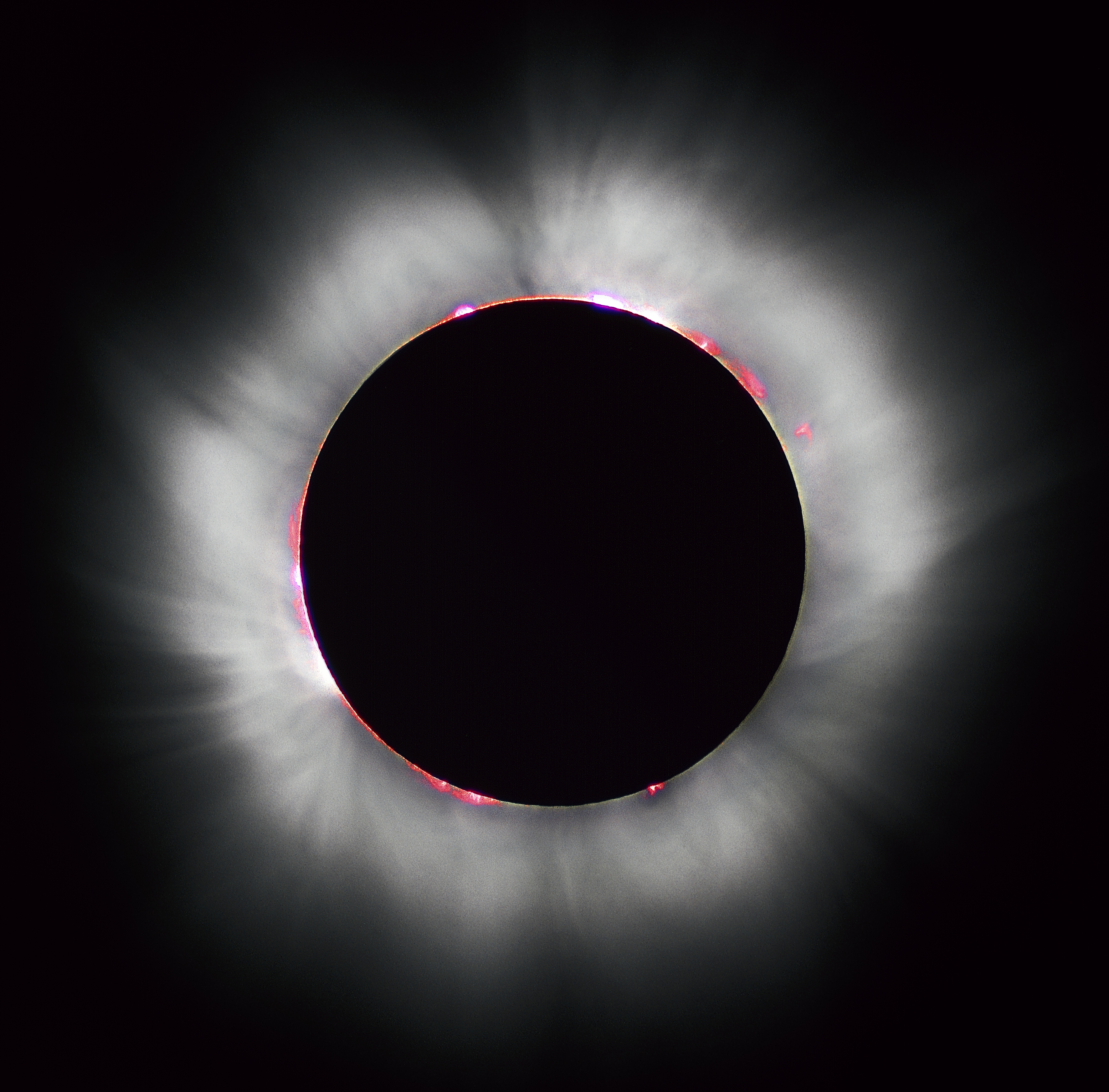
A total solar eclipse occurred on June 20, 1955. A solar eclipse occurs when the Moon passes between Earth and the Sun, thereby totally or partly obscuring the image of the Sun for a viewer on Earth. A total solar eclipse occurs when the Moon's apparent diameter is larger than the Sun's, blocking all direct sunlight, turning day into darkness. Totality occurs in a narrow path across Earth's surface, with the partial solar eclipse visible over a surrounding region thousands of kilometres wide. With a maximum duration of 7 minutes 7.74 seconds, this is the longest solar eclipse of saros series 136, as well as the longest total solar eclipse since the 11th century, and until the 22nd century, because greatest eclipse occurred near the Equator. Totality beginning over the Indian Ocean, British Seychelles (today's Seychelles) and Maldives, crossing Ceylon (name changed to Sri Lanka later) including the capital city Colombo, Andaman Islands, Burma, Thailand including the capital city Bang ... [...More Info...] [...Related Items...] OR: [Wikipedia] [Google] [Baidu] |
Solar Eclipse
A solar eclipse occurs when the Moon passes between Earth and the Sun, thereby obscuring the view of the Sun from a small part of the Earth, totally or partially. Such an alignment occurs during an eclipse season, approximately every six months, during the new moon phase, when the Moon's orbital plane is closest to the plane of the Earth's orbit. In a total eclipse, the disk of the Sun is fully obscured by the Moon. In partial and annular eclipses, only part of the Sun is obscured. Unlike a lunar eclipse, which may be viewed from anywhere on the night side of Earth, a solar eclipse can only be viewed from a relatively small area of the world. As such, although total solar eclipses occur somewhere on Earth every 18 months on average, they recur at any given place only once every 360 to 410 years. If the Moon were in a perfectly circular orbit and in the same orbital plane as Earth, there would be total solar eclipses once a month, at every new moon. Instead, because the ... [...More Info...] [...Related Items...] OR: [Wikipedia] [Google] [Baidu] |
Scarborough Shoal
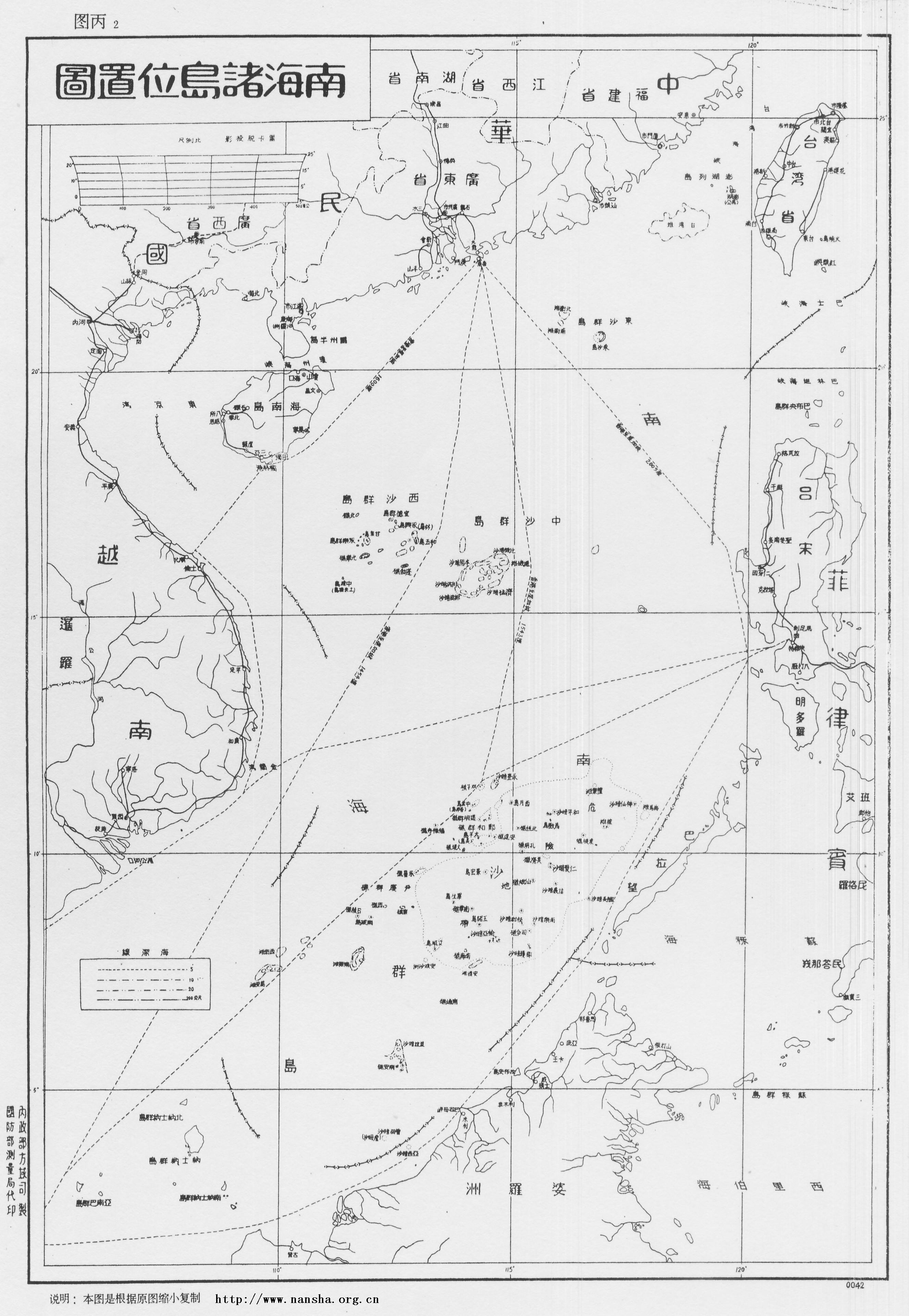
Scarborough Shoal, also known as Bajo de Masinloc (in Spanish), Panatag Shoal ( fil, Kulumpol ng Panatag, lit=serene cluster), Huangyan Island (Mandarin zh, c=黄岩岛, p=Huáng Yán Dǎo, l=yellow rock island), and Democracy Reef, are two rocks in a shoal located between Luzon and Macclesfield Bank within the Philippine EEZ in the South China Sea. It is away from the nearest landmass of Luzon, the largest island of the Philippines. It is a disputed territory claimed by the Republic of the Philippines through the 1734 Velarde map, while the People's Republic of China and the Republic of China (Taiwan) claim it through the disputed nine-dash line (originally an eleven-dash line which included waters in the Gulf of Tonkin). The shoal's status is often discussed in conjunction with other territorial disputes in the South China Sea such as those involving the Spratly Islands, and the 2012 Scarborough Shoal standoff. It was administered by the Philippines as part of its Zambal ... [...More Info...] [...Related Items...] OR: [Wikipedia] [Google] [Baidu] |
SE1926Jul09A
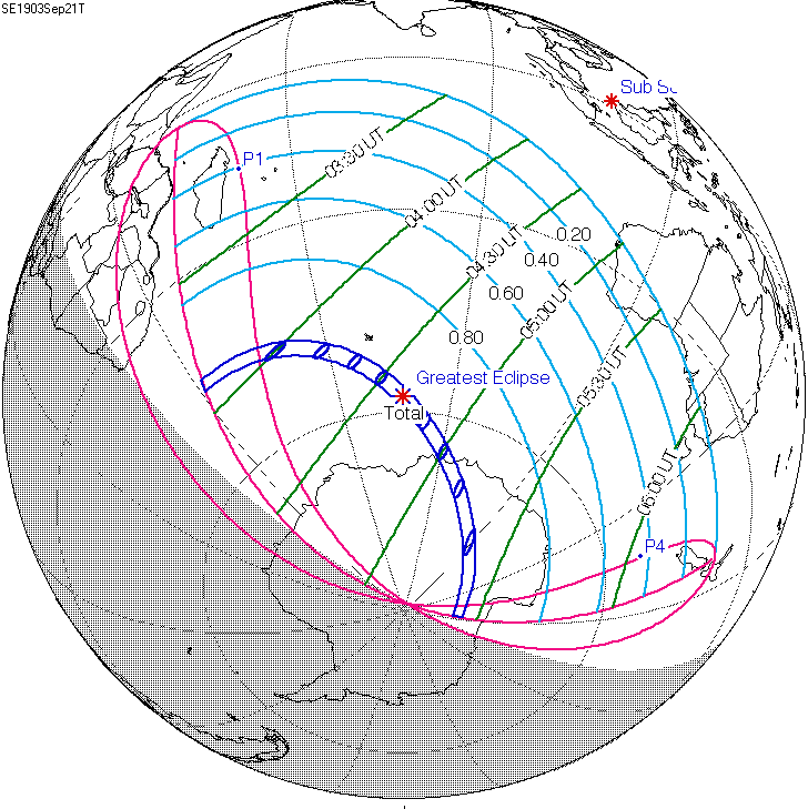
The SE (South Eastern) postcode area covers a broad radial swathe of the south-east of the London post town from the Albert Embankment to West Heath and the nearest edges of Sidcup and Selhurst. It loosely corresponds to the boroughs of Southwark, Lewisham and Greenwich plus indicated parts of the boroughs of Croydon (north), Lambeth (east), Bexley (west) and Bromley (its northwest corner). Postal administration The postcode area originated in 1857 as the SE district. In 1868 it gained some of the area of the short-lived S district, with the rest going to SW. It was divided into numbered districts in 1917, by giving the district closest to London that hosted the head office the suffix "1" and all others alphabetically based on a locally important parish, chapelry, topological or built environment feature administering or close to the local distribution office. SE28 is a late addition carved out of the existing districts SE2 and SE18 to reflect the building up of a new London di ... [...More Info...] [...Related Items...] OR: [Wikipedia] [Google] [Baidu] |
Solar Eclipse Of April 19, 1958
An annular solar eclipse occurred on April 19, 1958. A solar eclipse occurs when the Moon passes between Earth and the Sun, thereby totally or partly obscuring the image of the Sun for a viewer on Earth. An annular solar eclipse occurs when the Moon's apparent diameter is smaller than the Sun's, blocking most of the Sun's light and causing the Sun to look like an annulus (ring). An annular eclipse appears as a partial eclipse over a region of the Earth thousands of kilometres wide. Annularity was visible in the Maldives, Nicobar Islands, Burma, Thailand including the capital city Bangkok, Cambodia, Laos, North Vietnam and South Vietnam (now belonging to Vietnam), China, British Hong Kong, Taiwan, Ryukyu Islands and Japan. It was the fourth central solar eclipse visible from Bangkok from 1948 to 1958, where it is rare for a large city to witness 4 central solar eclipses in just 9.945 years. Places east of International Date line witnessed the eclipse on April 18th (Friday). O ... [...More Info...] [...Related Items...] OR: [Wikipedia] [Google] [Baidu] |
Solar Eclipse Of May 9, 1948
An annular solar eclipse occurred on May 9, 1948. A solar eclipse occurs when the Moon passes between Earth and the Sun, thereby totally or partly obscuring the image of the Sun for a viewer on Earth. An annular solar eclipse occurs when the Moon's apparent diameter is smaller than the Sun's, blocking most of the Sun's light and causing the Sun to look like an annulus (ring). An annular eclipse appears as a partial eclipse over a region of the Earth thousands of kilometres wide. Annularity was visible from Car Nicobar, the northernmost of the Nicobar Islands, and Burma, Thailand including Bangkok, French Indochina (the part now belonging to Laos), North Vietnam (now belonging to Vietnam), China, South Korea, Rebun Island in Japan, Kuril Islands in the Soviet Union (now belonging to Russia) on May 9th, and Alaska on May 8th. It was the first central solar eclipse visible from Bangkok from 1948 to 1958 Events January * January 1 – The European Econom ... [...More Info...] [...Related Items...] OR: [Wikipedia] [Google] [Baidu] |
Solomon Islands
Solomon Islands is an island country consisting of six major islands and over 900 smaller islands in Oceania, to the east of Papua New Guinea and north-west of Vanuatu. It has a land area of , and a population of approx. 700,000. Its capital, Honiara, is located on the largest island, Guadalcanal. The country takes its name from the wider area of the Solomon Islands (archipelago), which is a collection of Melanesian islands that also includes the Autonomous Region of Bougainville (currently a part of Papua New Guinea), but excludes the Santa Cruz Islands. The islands have been settled since at least some time between 30,000 and 28,800 BCE, with later waves of migrants, notably the Lapita people, mixing and producing the modern indigenous Solomon Islanders population. In 1568, the Spanish navigator Álvaro de Mendaña was the first European to visit them. Though not named by Mendaña, it is believed that the islands were called ''"the Solomons"'' by those who later r ... [...More Info...] [...Related Items...] OR: [Wikipedia] [Google] [Baidu] |
British Solomon Islands
The British Solomon Islands Protectorate was first declared over the southern Solomons in 1893, when Captain Gibson, R.N., of , declared the southern islands a British protectorate. Other islands were subsequently declared to form part of the Protectorate. Establishment and addition of islands After the Anglo-German Declarations about the Western Pacific Ocean, the Protectorate was first declared over the southern Solomons in 1893. The formalities in its establishment were carried out by officers of the Royal Navy, who hoisted the British flag and read Proclamations on twenty-one islands. In April 1896, Charles Morris Woodford was appointed as an Acting Deputy Commissioner of the British Western Pacific Territories. From 30 May to 10 August 1896, HMS ''Pylades'' toured through the Solomon Islands archipelago with Woodford, who had been sent to survey the islands and to report on the economic feasibility of the British Solomon Islands Protectorate. On 29 September 189 ... [...More Info...] [...Related Items...] OR: [Wikipedia] [Google] [Baidu] |
Ontong Java Atoll
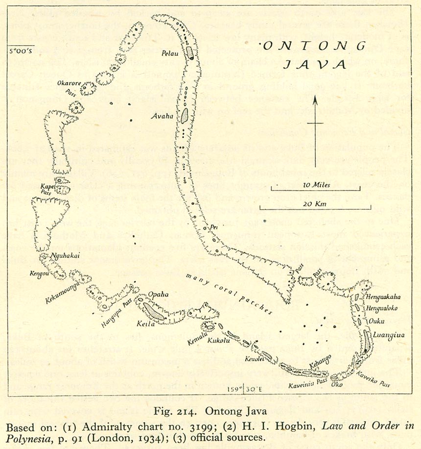
Ontong Java Atoll or Luangiua, (formerly ''Lord Howe Atoll'', not to be confused with Lord Howe Island) is one of the largest atolls on earth. Geographically it belongs to a scattered group of three atolls which includes nearby Nukumanu Atoll and the wholly submerged Roncador Reef located to the south. Description Administratively Ontong Java belongs to Solomon Islands Solomon Islands is an island country consisting of six major islands and over 900 smaller islands in Oceania, to the east of Papua New Guinea and north-west of Vanuatu. It has a land area of , and a population of approx. 700,000. Its ca .... As an outlying part of Malaita Province, it forms the northernmost tract of land of this state, over north of Santa Isabel Island. The closest land, however, is Nukumanu Atoll, which lies only due north of Ontong Java's northern tip and, though historically closely related to Ontong Java, is now under the administration of Papua New Guinea. Ontong Java is ... [...More Info...] [...Related Items...] OR: [Wikipedia] [Google] [Baidu] |
Papua New Guinea
Papua New Guinea (abbreviated PNG; , ; tpi, Papua Niugini; ho, Papua Niu Gini), officially the Independent State of Papua New Guinea ( tpi, Independen Stet bilong Papua Niugini; ho, Independen Stet bilong Papua Niu Gini), is a country in Oceania that comprises the eastern half of the island of New Guinea and its offshore islands in Melanesia (a region of the southwestern Pacific Ocean north of Australia). Its capital, located along its southeastern coast, is Port Moresby. The country is the world's third largest island country, with an area of . At the national level, after being ruled by three external powers since 1884, including nearly 60 years of Australian administration starting during World War I, Papua New Guinea established its sovereignty in 1975. It became an independent Commonwealth realm in 1975 with Elizabeth II as its queen. It also became a member of the Commonwealth of Nations in its own right. There are 839 known languages of Papua New Guinea, on ... [...More Info...] [...Related Items...] OR: [Wikipedia] [Google] [Baidu] |
Territory Of Papua New Guinea
The Territory of Papua and New Guinea, officially the Administrative Union of the Territory of Papua and the Territory of New Guinea, was established by an administrative union between the Australian-administered territories of Papua and New Guinea (the latter being a United Nations trust territory administered by Australia) in 1949. In December 1971, the name of the Territory changed to "Papua New Guinea" and in 1975 it became the Independent State of Papua New Guinea. Background Ancient history Archeological evidence suggests that humans arrived on New Guinea around 50,000 years ago. These Melanesian people developed stone tools and agriculture. Portuguese and Spanish navigators sailing in the South Pacific entered New Guinea waters in the early part of the 16th century and in 1526–27, Jorge de Menezes came upon the principal island "Papua". In 1545, the Spaniard Iñigo Ortiz de Retes gave the island the name "New Guinea" because of what he saw as a resemblance between ... [...More Info...] [...Related Items...] OR: [Wikipedia] [Google] [Baidu] |
Nukumanu Islands
The Nukumanu Islands, formerly the Tasman Islands, is an atoll of Papua New Guinea, located in the south-western Pacific Ocean, 4 degrees south of the Equator. Description Comprising a ring of more than twenty islets on a reef surrounding a large lagoon, Nukumanu's sandy islands are located on a strip of coral rising no more than above sea level. The main inhabited islands of Nukumanu are located on the eastern end of the atoll. Administratively Nukumanu is part of the Autonomous Region of Bougainville in Papua New Guinea, but it lies quite far away from the closest territory of Papua New Guinea proper, which is the coast of New Ireland island at to the west. The nearest land is Ontong Java Atoll, located only to the south of Nukumanu. The border between Papua New Guinea and the Solomon Islands runs between these neighboring atolls, which form a small geographic group together with the wholly submerged Roncador Reef at the southern end. History In Polynesian history, the m ... [...More Info...] [...Related Items...] OR: [Wikipedia] [Google] [Baidu] |
Palau
Palau,, officially the Republic of Palau and historically ''Belau'', ''Palaos'' or ''Pelew'', is an island country and microstate in the western Pacific. The nation has approximately 340 islands and connects the western chain of the Caroline Islands with parts of the Federated States of Micronesia. It has a total area of . The most populous island is Koror, home to the country's most populous city of the same name. The capital Ngerulmud is located on the nearby island of Babeldaob, in Melekeok State. Palau shares maritime boundaries with international waters to the north, the Federated States of Micronesia to the east, Indonesia to the south, and the Philippines to the northwest. The country was originally settled approximately 3,000 years ago by migrants from Maritime Southeast Asia. Palau was first drawn on a European map by the Czech missionary Paul Klein based on a description given by a group of Palauans shipwrecked on the Philippine coast on Samar. Pal ... [...More Info...] [...Related Items...] OR: [Wikipedia] [Google] [Baidu] |


