|
Sheep Island (England)
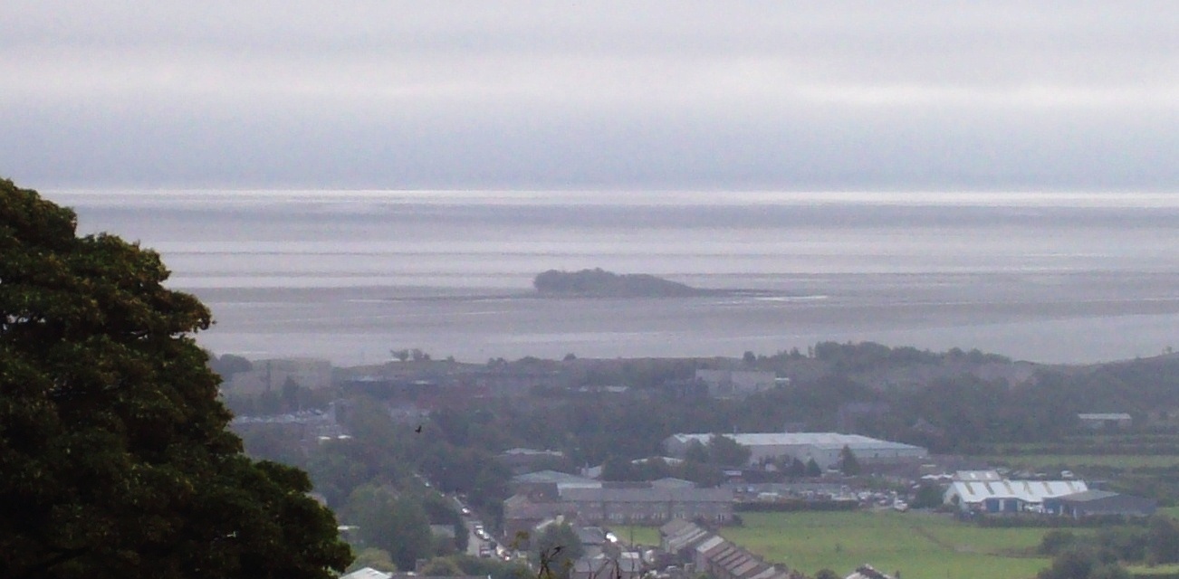
Sheep Island is an uninhabited grassy island of around , located just over from the shore of Walney Island, opposite Snab Point. It is one of the Islands of Furness and is in the Borough of Barrow-in-Furness in Cumbria in north-west England. The island's geographic location is, using the British national grid reference system, . Sheep Island is accessible on foot at low tide from either Walney, or from Piel Island - a distance of about a mile (approx. 1.5 km). The island is uninhabited and there is no shelter. Between 1892 and 1922 it included a small isolation hospital located within a wooden building, which was erected by Barrow Borough Council at a cost of £257 but seldom used. Islands of Furness Uninhabited islands of England Barrow-in-Furness {{Cumbria-geo-stub ... [...More Info...] [...Related Items...] OR: [Wikipedia] [Google] [Baidu] |
Morecambe Bay
Morecambe Bay is a large estuary in northwest England, just to the south of the Lake District National Park. It is the largest expanse of intertidal mudflats and sand in the United Kingdom, covering a total area of . In 1974, the second largest gas field in the UK was discovered west of Blackpool, with original reserves of over 7 trillion cubic feet (tcf) (200 billion cubic metres). At its peak, 15% of Britain's gas supply came from the bay but production is now in decline. It is also one of the homes of the high brown fritillary butterfly. Natural features The rivers Leven, Kent, Keer, Lune and Wyre drain into the Bay, with their various estuaries making a number of peninsulas within the bay. Much of the land around the bay is reclaimed, forming salt marshes used in agriculture. Morecambe Bay is also an important wildlife site, with abundant birdlife and varied marine habitats, and there is a bird observatory at Walney Island. The bay has rich cockle beds, which have been ... [...More Info...] [...Related Items...] OR: [Wikipedia] [Google] [Baidu] |
British Isles
The British Isles are a group of islands in the North Atlantic Ocean off the north-western coast of continental Europe, consisting of the islands of Great Britain, Ireland, the Isle of Man, the Inner and Outer Hebrides, the Northern Isles, and over six thousand smaller islands."British Isles", ''Encyclopædia Britannica''. They have a total area of and a combined population of almost 72 million, and include two sovereign states, the Republic of Ireland (which covers roughly five-sixths of Ireland), and the United Kingdom of Great Britain and Northern Ireland. The Channel Islands, off the north coast of France, are normally taken to be part of the British Isles, even though they do not form part of the archipelago. The oldest rocks are 2.7 billion years old and are found in Ireland, Wales and the northwest of Scotland. During the Silurian period, the north-western regions collided with the south-east, which had been part of a separate continental landmass. The ... [...More Info...] [...Related Items...] OR: [Wikipedia] [Google] [Baidu] |
Cumbria
Cumbria ( ) is a ceremonial and non-metropolitan county in North West England, bordering Scotland. The county and Cumbria County Council, its local government, came into existence in 1974 after the passage of the Local Government Act 1972. Cumbria's county town is Carlisle, in the north of the county. Other major settlements include Barrow-in-Furness, Kendal, Whitehaven and Workington. The administrative county of Cumbria consists of six districts ( Allerdale, Barrow-in-Furness, Carlisle, Copeland, Eden and South Lakeland) and, in 2019, had a population of 500,012. Cumbria is one of the most sparsely populated counties in England, with 73.4 people per km2 (190/sq mi). On 1 April 2023, the administrative county of Cumbria will be abolished and replaced with two new unitary authorities: Westmorland and Furness (Barrow-in-Furness, Eden, South Lakeland) and Cumberland ( Allerdale, Carlisle, Copeland). Cumbria is the third largest ceremonial county in England by area. It i ... [...More Info...] [...Related Items...] OR: [Wikipedia] [Google] [Baidu] |
Walney Island
Walney Island, also known as the Isle of Walney, is an island off the west coast of England, at the western end of Morecambe Bay in the Irish Sea. It is part of Barrow-in-Furness, separated from the mainland by Walney Channel, which is spanned by the Jubilee Bridge. Walney is the largest island of the Furness Islands group, both in population and size, as well as the largest English island in the Irish Sea. Its population at the 2011 UK Census was 10,651, distributed evenly across the island's two Wards of Walney North and Walney South. Walney Island formed during the last glacial period, when the River Duddon was a large glacial lake, depositing till at its mouth, which became Walney. Some evidence of neolithic inhabitants has been found in the island's sand dunes, though its name is likely of Norse origin.Walney Island His ... [...More Info...] [...Related Items...] OR: [Wikipedia] [Google] [Baidu] |
Islands Of Furness
The Islands of Furness are situated to the south-west and east of the Furness Peninsula. Within England, they are the third biggest collection of islands. They are generally quite small, though at 12.99 km2 Walney Island is the eighth biggest in England. Of these, only Walney Island, Barrow Island, Roa Island and Piel Island are inhabited. The majority of the islands lie within the boundary of the Borough of Barrow-in-Furness, with some 15,000 residents constituting 20% of the district's population. They are the largest group of islands between Anglesey in Wales and the Firth of Clyde in Scotland. The main islands are: *Walney Island - Population 10,651 (Settlements include Biggar, North Scale, North Walney and Vickerstown) *Barrow Island - Population 2,616 * Sheep Island - Population 0 *Roa Island - Population ~100 *Piel Island - Population ~10 *Foulney Island - Population 0 *Chapel Island - Population 0 As well as these, the small islets of Dova Haw, also known as ... [...More Info...] [...Related Items...] OR: [Wikipedia] [Google] [Baidu] |
Barrow-in-Furness
Barrow-in-Furness is a port town in Cumbria, England. Historically in Lancashire, it was incorporated as a municipal borough in 1867 and merged with Dalton-in-Furness Urban District in 1974 to form the Borough of Barrow-in-Furness. In 2023 the borough will merge with Eden and South Lakeland districts to form a new unitary authority; Westmorland and Furness. At the tip of the Furness peninsula, close to the Lake District, it is bordered by Morecambe Bay, the Duddon Estuary and the Irish Sea. In 2011, Barrow's population was 56,745, making it the second largest urban area in Cumbria after Carlisle. Natives of Barrow, as well as the local dialect, are known as Barrovian. In the Middle Ages, Barrow was a small hamlet within the parish of Dalton-in-Furness with Furness Abbey, now on the outskirts of the town, controlling the local economy before its dissolution in 1537. The iron prospector Henry Schneider arrived in Furness in 1839 and, with other investors, opened the Furness Railwa ... [...More Info...] [...Related Items...] OR: [Wikipedia] [Google] [Baidu] |
British National Grid Reference System
The Ordnance Survey National Grid reference system (OSGB) (also known as British National Grid (BNG)) is a system of geographic grid references used in Great Britain, distinct from latitude and longitude. The Ordnance Survey (OS) devised the national grid reference system, and it is heavily used in their survey data, and in maps based on those surveys, whether published by the Ordnance Survey or by commercial map producers. Grid references are also commonly quoted in other publications and data sources, such as guide books and government planning documents. A number of different systems exist that can provide grid references for locations within the British Isles: this article describes the system created solely for Great Britain and its outlying islands (including the Isle of Man); the Irish grid reference system was a similar system created by the Ordnance Survey of Ireland and the Ordnance Survey of Northern Ireland for the island of Ireland. The Universal Transverse Merca ... [...More Info...] [...Related Items...] OR: [Wikipedia] [Google] [Baidu] |
Piel Island
Piel Island lies in Morecambe Bay , around off the southern tip of the Furness peninsula in the administrative county of Cumbria, England. It is one of the Islands of Furness, three of which sit near to Piel at the mouth of Walney Channel. The island is the location of Piel Castle, built by the monks of Furness Abbey in the fourteenth century. Historically within Lancashire, the island today is owned by the town of Barrow-in-Furness, having been given to the people by the Duke of Buccleuch in 1922. The Borough Council's administrative duties also include the selection of the "King" of Piel, who is the landlord of the island's public house, the Ship Inn. Piel is about in size. The landlord and their family are usually the only permanent residents, though there are eight old fishermen's cottages which are used by sailors or as second homes. History In the Middle Ages Piel was known as Fowdray (or Fouldrey or Fowdrey) island. This name would seem to be derived from the Old Nor ... [...More Info...] [...Related Items...] OR: [Wikipedia] [Google] [Baidu] |
Barrow Borough Council
Barrow-in-Furness is a local government district with borough status in Cumbria, England. It is named after its main town, Barrow-in-Furness. Other settlements include Dalton-in-Furness and Askam-in-Furness. It is the smallest district in the county, but is the most densely populated, with 924 people per square kilometre. The population was 71,980 in 2001, reducing to 69,087 at the 2011 Census. In July 2021 the Ministry of Housing, Communities and Local Government announced that in April 2023, Cumbria will be reorganised into two unitary authorities. Barrow-in-Furness Borough Council is to be abolished and its functions transferred to a new authority, to be known as Westmorland and Furness, which will cover the current districts of Barrow-in-Furness, Eden and South Lakeland. In April 2022 Gareth Davies became the first person to run every single street in the Borough of Barrow-In-Furness. Covering all 1,026 streets over an end to end distance of 201 miles. Background The are ... [...More Info...] [...Related Items...] OR: [Wikipedia] [Google] [Baidu] |
Uninhabited Islands Of England
The list of uninhabited regions includes a number of places around the globe. The list changes year over year as human beings migrate into formerly uninhabited regions, or migrate out of formerly inhabited regions. List As a group, the list of uninhabited places are called the "nonecumene". This is a special geography term which means the uninhabited area of the world. * Virtually all of the Ocean *Virtually all of Antarctica *Most of The Arctic *Most of Greenland *Most of The Sahara * Antipodes Islands * Ashmore and Cartier Islands * Bajo Nuevo Bank * Baker Island * Ball's Pyramid * Balleny Islands * Big Major Cay * Bouvet Island * Much of the interior of Brazil * Caroline Island * Clipperton Island * The semi-arid regions and deserts of Australia * Devon Island * Much of Eastern Oregon * Elephant Island * Elobey Chico * Ernst Thälmann Island * Much of Fiordland, New Zealand * Goa Island * Gough Island * Hans Island * Harmil * Hashima Island * Hatutu * Heard Island ... [...More Info...] [...Related Items...] OR: [Wikipedia] [Google] [Baidu] |


