|
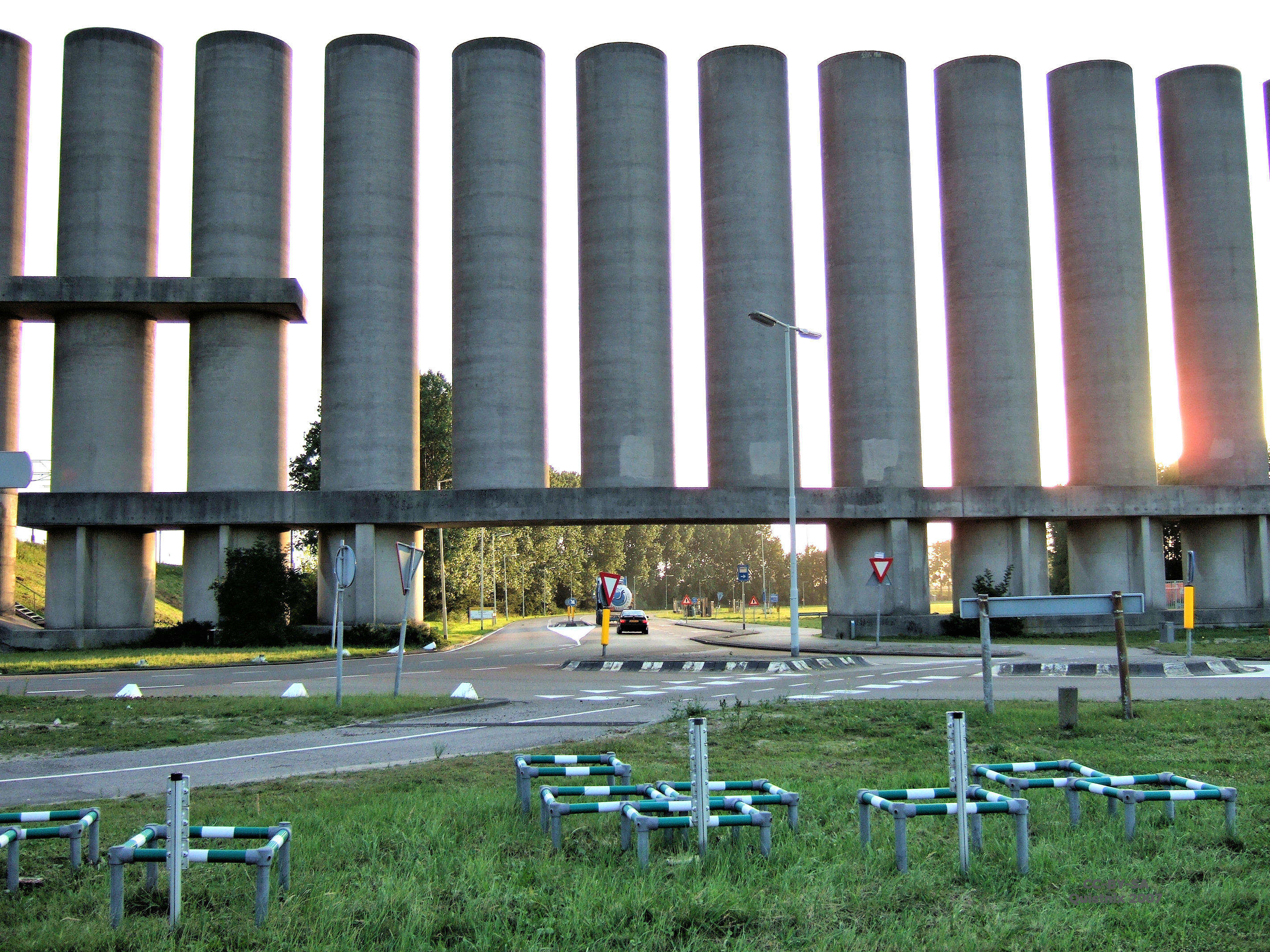
Rozenburg Wind Wall
Rozenburg wind wall in Rozenburg, Netherlands, is a wall built to block wind from entering the Calandkanaal, and ease the passage of large cargo ship A cargo ship or freighter is a merchant ship that carries cargo, goods, and materials from one port to another. Thousands of cargo carriers ply the world's seas and oceans each year, handling the bulk of international trade. Cargo ships are usu ...s through the narrow canal, particularly through the Calandbrug bridge. The wall blocks about 75% of the wind and allows the ships to pass smoothly. The wall is 1600 meters long and it is made up of 125 rectangular and cylindrical slabs, each about 25 meters tall and 18 meters wide. References Buildings and structures in Rotterdam {{SouthHolland-geo-stub ... [...More Info...] [...Related Items...] OR: [Wikipedia] [Google] [Baidu] |
Rozenburg
Rozenburg () is a town and former municipality in the western Netherlands, in the province of South Holland. The municipality had a population of 13,173 in 2004, and covers an area of 6.50 km² (of which 1.99 km² water). It was the second-smallest municipality in the Netherlands in area (behind Bennebroek). On 10 July 2008, the local council decided to disband the municipality and to form a submunicipality of Rotterdam. This was ratified on 27 October 2008 by the Eerste Kamer (the Dutch Senate), and came into effect on 18 March 2010. The town is located on the former island by the same name: Rozenburg Island. Its current form was created out of three separate parts: Rozenburg proper (a former sand bar between Het Scheur and Brielse Maas – part of the Nieuwe Maas river – both being branches of the Rhine–Meuse–Scheldt delta), the sand bar Welplaat, and the southernmost part of the Hook of Holland (which was cut off from mainland Holland by the construction of ... [...More Info...] [...Related Items...] OR: [Wikipedia] [Google] [Baidu] |
Netherlands
) , anthem = ( en, "William of Nassau") , image_map = , map_caption = , subdivision_type = Sovereign state , subdivision_name = Kingdom of the Netherlands , established_title = Before independence , established_date = Spanish Netherlands , established_title2 = Act of Abjuration , established_date2 = 26 July 1581 , established_title3 = Peace of Münster , established_date3 = 30 January 1648 , established_title4 = Kingdom established , established_date4 = 16 March 1815 , established_title5 = Liberation Day (Netherlands), Liberation Day , established_date5 = 5 May 1945 , established_title6 = Charter for the Kingdom of the Netherlands, Kingdom Charter , established_date6 = 15 December 1954 , established_title7 = Dissolution of the Netherlands Antilles, Caribbean reorganisation , established_date7 = 10 October 2010 , official_languages = Dutch language, Dutch , languages_type = Regional languages , languages_sub = yes , languages = , languages2_type = Reco ... [...More Info...] [...Related Items...] OR: [Wikipedia] [Google] [Baidu] |
Port Of Rotterdam
The Port of Rotterdam is the largest seaport in Europe, and the world's largest seaport outside of East Asia, located in and near the city of Rotterdam, in the province of South Holland in the Netherlands. From 1962 until 2004, it was the List of busiest ports by cargo tonnage, world's busiest port by annual cargo tonnage. It was overtaken first in 2004 by the port of Singapore, and since then by Port of Shanghai, Shanghai and other very large Chinese seaports. In 2020, Rotterdam was List of busiest container ports, the world's tenth-largest container port in terms of twenty-foot equivalent units (TEU) handled. In 2017, Rotterdam was also the world's tenth-largest cargo port in terms of annual cargo tonnage. Covering , the port of Rotterdam now stretches over a distance of . It consists of the city centre's historic harbour area, including Delfshaven; the Maashaven/Rijnhaven/Feijenoord complex; the harbours around Nieuw-Mathenesse; Waalhaven; Vondelingenplaat; Eemhaven; Botlek; E ... [...More Info...] [...Related Items...] OR: [Wikipedia] [Google] [Baidu] |
Cargo Ship
A cargo ship or freighter is a merchant ship that carries cargo, goods, and materials from one port to another. Thousands of cargo carriers ply the world's seas and oceans each year, handling the bulk of international trade. Cargo ships are usually specially designed for the task, often being equipped with crane (machine), cranes and other mechanisms to load and unload, and come in all sizes. Today, they are almost always built of welded steel, and with some exceptions generally have a life expectancy of 25 to 30 years before being scrapped. Definitions The words ''cargo'' and ''freight'' have become interchangeable in casual usage. Technically, "cargo" refers to the goods carried aboard the ship for hire, while "freight" refers to the act of carrying of such cargo, but the terms have been used interchangeably for centuries. Generally, the modern ocean shipping business is divided into two classes: # Liner business: typically (but not exclusively) container vessels (where ... [...More Info...] [...Related Items...] OR: [Wikipedia] [Google] [Baidu] |
Canal
Canals or artificial waterways are waterways or engineered channels built for drainage management (e.g. flood control and irrigation) or for conveyancing water transport vehicles (e.g. water taxi). They carry free, calm surface flow under atmospheric pressure, and can be thought of as artificial rivers. In most cases, a canal has a series of dams and locks that create reservoirs of low speed current flow. These reservoirs are referred to as ''slack water levels'', often just called ''levels''. A canal can be called a ''navigation canal'' when it parallels a natural river and shares part of the latter's discharges and drainage basin, and leverages its resources by building dams and locks to increase and lengthen its stretches of slack water levels while staying in its valley. A canal can cut across a drainage divide atop a ridge, generally requiring an external water source above the highest elevation. The best-known example of such a canal is the Panama Canal. Many ... [...More Info...] [...Related Items...] OR: [Wikipedia] [Google] [Baidu] |


