|
Route Nationale 10 (Madagascar)
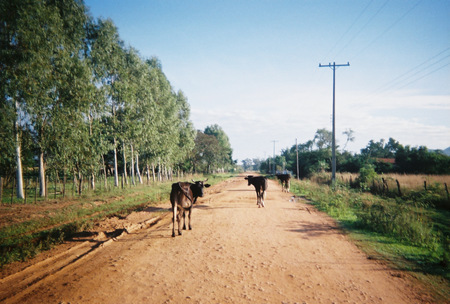
''Route nationale 10 '' (''RN 10'') is an unpaved, secondary highway in Madagascar of 512 km, running from Andranovory to Ambovombe. It crosses the regions of Atsimo-Andrefana and Androy. Selected locations on route West to East: *Andranovory - intersection with RN 7 (Tulear - Fianarantsoa - Antananarivo) *Tameantsoa - Onilahy River crossing *Betioky - Beza Mahafaly Reserve at 35 km north-east * Ambatry * Mahazoarivo - intersection secondary road to Vohitsara and Akazomateila (Mahafaly graves) & Tsimanampetsotse National Park *Ejeda - dirt road to the coast to Itampolo & Linta River crossing * Manakaralahy - Manakaralahy River crossing * Sakoambe *Ampanihy *Tranoroa - Menarandra River crossing * Andamilamy *Beloha *Tsiombe * Ambondro * Ambovombe - intersection with RN 13 (Ihosy - Tôlanaro) See also * List of roads in Madagascar *Transport in Madagascar Paved and unpaved roadways, as well as railways, provide the main forms of transport in Madagascar. Madagasc ... [...More Info...] [...Related Items...] OR: [Wikipedia] [Google] [Baidu] |
Menarandra River
Menarandra is a river in the regions of Androy and Atsimo-Andrefana in southern Madagascar. It flows into the Indian Ocean near Bevoalavo Est. Its annual discharge is low, approx. 2-3 L/s/km at Tranoroa. References Rivers of Atsimo-Andrefana Rivers of Madagascar {{Madagascar-river-stub ... [...More Info...] [...Related Items...] OR: [Wikipedia] [Google] [Baidu] |
Tranoroa
Tranoroa is a town and commune in Madagascar. It belongs to the district of Beloha, which is a part of Androy Region. It is situated at the Menarandra River and the Route Nationale No.10. The population of the commune was estimated to be approximately 18,000 in 2001 commune census. Primary and junior level secondary education are available in town. It is also a site of industrial-scale mining. Farming and raising livestock provides employment for 45% and 45% of the working population. The most important crops are maize and peanuts; also cassava ''Manihot esculenta'', common name, commonly called cassava (), manioc, or yuca (among numerous regional names), is a woody shrub of the spurge family, Euphorbiaceae, native to South America. Although a perennial plant, cassava is extensively ... is an important agricultural product. Industry and services provide employment for 2% and 8% of the population, respectively. References and notes Populated places in Androy ... [...More Info...] [...Related Items...] OR: [Wikipedia] [Google] [Baidu] |
Ampanihy
Ampanihy or Ampanihy Ouest is a town in the Atsimo-Andrefana Region, Madagascar. It is home of the Ampanihy Airport and is crossed by the Route Nationale 10. Economy The weaving of rugs from mohair Mohair (pronounced ) is a fabric or yarn made from the hair of the Angora goat. (This should not be confused with Angora wool, which is made from the fur of the Angora rabbit.) Both durable and resilient, mohair is notable for its high luster ... is the most important economic activity since 1914. References Populated places in Atsimo-Andrefana {{AtsimoAndrefana-geo-stub ... [...More Info...] [...Related Items...] OR: [Wikipedia] [Google] [Baidu] |
Linta River
''Linta'' is a river in the region of Atsimo-Andrefana in southern Madagascar. It crosses the Route nationale 10 near Ejeda and flows into the Indian Ocean in the Bay of Langarano, east of Androka Androka is a rural municipality in southwestern Madagascar. It belongs to the district of Ampanihy, which is a part of Atsimo-Andrefana Region. It has a population of 39168 inhabitants in 2018. Primary and junior level secondary education are ava .... Its main affluents are the Manakaralahy and Manakaravavy which are dry during the dry season from July to November. Its annual discharge is low, approx. 1-2 L/s/km. References Rivers of Atsimo-Andrefana Rivers of Madagascar {{Madagascar-river-stub ... [...More Info...] [...Related Items...] OR: [Wikipedia] [Google] [Baidu] |
Itampolo
Itampolo is a town and commune ( mg, kaominina) in southwestern Madagascar. It belongs to the district of Ampanihy, which is a part of Atsimo-Andrefana Region. The population of the commune was estimated to be approximately 32,000 in 2001 commune census. Only primary schooling is available. The majority 60% of the population of the commune are farmers, while an additional 20% receives their livelihood from raising livestock. The most important crops are cassava and peas, while other important agricultural products are maize and sweet potato The sweet potato or sweetpotato (''Ipomoea batatas'') is a dicotyledonous plant that belongs to the Convolvulus, bindweed or morning glory family (biology), family, Convolvulaceae. Its large, starchy, sweet-tasting tuberous roots are used as a r ...es. Services provide employment for 5% of the population. Additionally fishing employs 15% of the population. References and notes Populated places in Atsimo-Andrefana {{AtsimoAnd ... [...More Info...] [...Related Items...] OR: [Wikipedia] [Google] [Baidu] |
Dirt Road
A dirt road or track is a type of unpaved road not paved with asphalt, concrete, brick, or stone; made from the native material of the land surface through which it passes, known to highway engineers as subgrade material. Dirt roads are suitable for vehicles; a narrower path for pedestrians, animals, and possibly small vehicles would be called a dirt track—the distinction is not well-defined. Unpaved roads with a harder surface made by the addition of material such as gravel and aggregate (stones), might be referred to as dirt roads in common usage but are distinguished as improved roads by highway engineers. (Improved unpaved roads include gravel roads, laterite roads, murram roads and macadamized roads.) Compared to a gravel road, a dirt road is not usually graded regularly to produce an enhanced camber to encourage rainwater to drain off the road, and drainage ditches at the sides may be absent. They are unlikely to have embankments through low-lying areas. This lea ... [...More Info...] [...Related Items...] OR: [Wikipedia] [Google] [Baidu] |

