|
Route 515 (Afghanistan)
Route 515 is the main road in Bakwa District in Afghanistan. It is a compact gravel road that travels east–west and connects Delaram Delārām (Pashto/Persian: دلارام) is a city in the northern part of Nimruz Province, in southern Afghanistan. It is a major transportation center, with several major road converging on the area, including Kandahar–Herat Highway (part o ... on the east terminus with Farah City on the west terminus. The road is about 75 kilometers long and about 38 kilometers from Delaram to the Bakwa District Center. Route The Delaram end of the road starts at Highway 1 or Ring Road. The route intersects with Route 606 near Delaram and passes through the Bakwa District Center. Key points *East terminus (Delaram at Highway 1): *Intersection with Route 606: *Bakwa District Center: *West terminus (Farah City): History In 2009, it was under major improvement by an Afghan contracting company and was expected to be completed in June 2010. Notes ... [...More Info...] [...Related Items...] OR: [Wikipedia] [Google] [Baidu] |
Route 515 In Bakwa, Afghanistan Crop
Route or routes may refer to: * Route (gridiron football), a path run by a wide receiver * route (command), a program used to configure the routing table * Route, County Antrim, an area in Northern Ireland * '' The Route'', a 2013 Ugandan film * Routes, Seine-Maritime, a commune in Seine-Maritime, France * ''Routes'' (video game), 2003 video game See also * Acronyms and abbreviations in avionics * Air route or airway * GPS route, a series of one or more GPS waypoints * Path (other) * Rout, a disorderly retreat of military units from the field of battle * Route number or road number * Router (other) * Router (woodworking) * Routing (other) * Routing table * Scenic route, a thoroughfare designated as scenic based on the scenery through which it passes * Trade route A trade route is a logistical network identified as a series of pathways and stoppages used for the commercial transport of cargo. The term can also be used to refer to trade ov ... [...More Info...] [...Related Items...] OR: [Wikipedia] [Google] [Baidu] |
Bakwa District
Bakwa is a district in Farah Province, Afghanistan. Its population, which is majority Pashtun with a Tajik minority, was estimated at 79,529 in November 2004. The district center is Sultani Bakwa. It is situated at an altitude of 726 m. War in Afghanistan According to the Afghan government, airstrikes in 2019 against the Taliban in the district destroyed 68 drug labs and killed 150 insurgents. Governor Abdul Ghafoor Mujahid claimed 45 civilians were killed in the strikes, which Defense spokesman Qais Mangal denied. In 2021, the Taliban captured the district as part of the 2021 Taliban offensive A military offensive by the Taliban insurgent group and other allied militants led to the fall of the Islamic Republic of Afghanistan based in Kabul and marked the end of the nearly 20-year-old War in Afghanistan, that had begun following the .... Gallery Route_515_in_Bakwa,_Afghanistan.jpg, Route 515 in Bakwa References UNHCR District Profile compiled September–N ... [...More Info...] [...Related Items...] OR: [Wikipedia] [Google] [Baidu] |
Delaram
Delārām (Pashto/Persian: دلارام) is a city in the northern part of Nimruz Province, in southern Afghanistan. It is a major transportation center, with several major road converging on the area, including Kandahar–Herat Highway (part of the Ring Road), Route 515 to Farah, Route 522 to Gulistan and Route 606 to Iran. The district center contains a large bazaar. History Delaram was initially a city in Khash Rod District in Nimruz Province, but was administratively transferred to Farah Province in 2007 for a short time as a separate district. Delaram transitioned to Farah Province following a period of violence between ISAF and the Taliban, in which the Afghan Border Police were brought in to restore order.Gina Gillespie FMT PRT FarahDelaram joins Farah ISAF Mirror, Issue 38, April 2007. Delaram was then transferred back to Nimruz Province and remained a separate district of Nimruz. Climate Delaram has a hot desert climate (Köppen ''BWh''), characterised by little ... [...More Info...] [...Related Items...] OR: [Wikipedia] [Google] [Baidu] |
Farah, Afghanistan
Farah (Pashto/Dari: ) is the capital and largest city of Farah Province in western Afghanistan. It is located on the Farah River, close to the border with Iran. It is one of the largest cities of western Afghanistan in terms of population, with about 1.5 million people living in its urban area. Land use Farah is located in western Afghanistan between Kandahar and Herat, close to the border with Iran, although it lacks a direct road connection with the latter. Farah has a very clear grid of roads distributed through the higher-density residential areas. However barren land (35%) and vacant plots (25%) are the largest land uses and combine for 60% of total land use. History Ancient history The Citadel at Farah is probably one of a series of fortresses constructed by Alexander the Great, the city being an intermediate stop between Alexandria Arachosia (modern Kandahar) and Herat, the location of another of Alexander's fortresses. The "Alexandria" prefix was added to the c ... [...More Info...] [...Related Items...] OR: [Wikipedia] [Google] [Baidu] |
Highway 1 (Afghanistan)
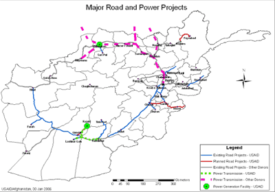
), is a two-lane road network circulating inside Afghanistan, connecting the following major cities (clockwise): Kabul, Maidan Shar, Ghazni, Kandahar, Delaram, Herat, Maymana, Sheberghan, Mazar-i-Sharif, Puli Khumri and back to Kabul. It has extensions that connect Jalalabad, Bamyan, Khost, Lashkargah, Zaranj ( Route 606), Farah, Islam Qala, Torghundi, and Kunduz. It is part of AH1, the longest route of the Asian Highway Network. National Highway 01 consists of four major sections, NH0101 to NH0104, linking the major economic centers. History Part of National Highway 1 has been refurbished since late 2003, particularly the Kabul–Kandahar Highway, with funds provided by the United States, Saudi Arabia and others. Most work on that stretch was done by Turkish, Indian and local companies. Japanese companies were also involved near the southern Afghan province of Kandahar. In the west, Iran participated in the two-lane road construction between Islam Qala and the western Afghan ... [...More Info...] [...Related Items...] OR: [Wikipedia] [Google] [Baidu] |
Route 606 (Afghanistan)
Route 606, also known as Delaram-Zaranj Highway or A71 is a 218 km roadwayBego, Bruno J ''Afghanistan International Security Force website'', August 30, 2011. Retrieved on September 10, 2011. in the Nimruz Province of Afghanistan connecting the Delaram District in Afghanistan to the border of Iran. The opposite way goes towards the south near Zaranj, Afghanistan. It is one of the busiest roads in Afghanistan and provides an important trade route between Iran and the rest of Asia. It was developed by India's Border Roads Organisation. The Delaram–Zaranj Highway, also known as ''Route 606'', is a 135-mile-long two-lane road in Afghanistan, connecting Zaranj in Nimruz Province, near the Iranian border, with Delaram in neighbouring Farah Province. It connects the Afghan–Iranian border with the Kandahar–Herat Highway in Delaram, which provides connectivity to other major Afghan cities via A01. Route 606 reduces travel time between Delaram and Zaranj from the earlier 12� ... [...More Info...] [...Related Items...] OR: [Wikipedia] [Google] [Baidu] |
Farah Province
Farah (Dari: , ''Farā'') is one of the 34 provinces of Afghanistan, located in the southwestern part of the country next to Iran. It is a spacious and sparsely populated province, divided into eleven districts and contains hundreds of villages. It has a population of about 563,026, which is multi-ethnic and mostly a rural tribal society. Farah's population is dominated by Pashtun (80%) tribesmen (Alizai, Barakzai,Noorzai) although Tajiks and a small minority of Shi'a Hazaras can also be found in the countryside. The Farah Airport is located near the city of Farah, which serves as the capital of the province. Farah is linked with Iran via the Iranian border town of Mahirud. The province famous tourism sites include Pul Garden, New Garden, Kafee Garden, shrine of Sultan Amir and Kafer castle are from sightseeing places of Farah provinc Geographically the province is approximately , making it (comparatively) more than twice the size of Maryland, or half the size of South Korea. Th ... [...More Info...] [...Related Items...] OR: [Wikipedia] [Google] [Baidu] |
Nimruz Province
Nimruz or Nimroz (Dari: ; Balochi: ) is one of the 34 provinces of Afghanistan, located in the southwestern part of the country. It lies to the east of the Sistan and Baluchestan Province of Iran and north of Balochistan, Pakistan, also bordering the Afghan provinces of Farah and Helmand. It has a population of about 186,963 people. The province is divided into five districts, encompassing about 649 villages. The city of Zaranj serves as the provincial capital and Zaranj Airport, which is located in that city, serves as a domestic airport for the province. The recently-built Kamal Khan Dam is located in Chahar Burjak District. The name ''Nimruz'' means "mid-day" or "half-day" in Balochi. The name is believed to indicate that the meridian cutting the old world in half passes through this region. Nimruz covers 43,000 km2. It is the most sparsely populated province in the country, located in the Sistan Basin. A substantial part of the province is the barren desert area of ... [...More Info...] [...Related Items...] OR: [Wikipedia] [Google] [Baidu] |
Roads In Afghanistan
Transport in Afghanistan is done mostly by road, rail and air. Much of the nation's road network was built in the mid-20th century but left to ruin during the last two decades of that century due to war and political turmoil. Officials of the current Islamic Emirate have continued to improve the national highways, roads, and bridges. In 2008, there were about 700,000 vehicles registered in Kabul. At least 1,314 traffic collisions were reported in 2022. Landlocked Afghanistan has no seaports, but the Amu River, which forms part of the nation's border with Turkmenistan, Uzbekistan and Tajikistan, does have substantial traffic. Rebuilding and expanding its airports, roads, rail network, and land ports has led to rapid economic growth in recent years. There are 46 airports in Afghanistan as of 2021. Road Most major highways were asphalted around the mid-20th century with assistance from the United States and the Soviet Union. The Soviets built a highway and tunnel through the Sa ... [...More Info...] [...Related Items...] OR: [Wikipedia] [Google] [Baidu] |


