|
Robinson's Hole
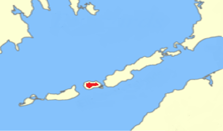
Robinson's Hole is the strait in Massachusetts' Elizabeth Islands separating Naushon Island from Pasque Island. It is one of four straits allowing maritime passage between Buzzards Bay and the Vineyard Sound. The others are Canapitsit Channel, Quick's Hole and Woods Hole Woods Hole is a census-designated place in the town of Falmouth in Barnstable County, Massachusetts, United States. It lies at the extreme southwest corner of Cape Cod, near Martha's Vineyard and the Elizabeth Islands. The population was 781 at .... Robinson's Hole is located in the town of Gosnold. References {{Coastal waterbodies of Massachusetts Straits of Massachusetts Gosnold, Massachusetts Bodies of water of Dukes County, Massachusetts ... [...More Info...] [...Related Items...] OR: [Wikipedia] [Google] [Baidu] |
Atlantic Ocean
The Atlantic Ocean is the second-largest of the world's five oceans, with an area of about . It covers approximately 20% of Earth's surface and about 29% of its water surface area. It is known to separate the " Old World" of Africa, Europe and Asia from the "New World" of the Americas in the European perception of the World. The Atlantic Ocean occupies an elongated, S-shaped basin extending longitudinally between Europe and Africa to the east, and North and South America to the west. As one component of the interconnected World Ocean, it is connected in the north to the Arctic Ocean, to the Pacific Ocean in the southwest, the Indian Ocean in the southeast, and the Southern Ocean in the south (other definitions describe the Atlantic as extending southward to Antarctica). The Atlantic Ocean is divided in two parts, by the Equatorial Counter Current, with the North(ern) Atlantic Ocean and the South(ern) Atlantic Ocean split at about 8°N. Scientific explorations of the A ... [...More Info...] [...Related Items...] OR: [Wikipedia] [Google] [Baidu] |
Strait
A strait is an oceanic landform connecting two seas or two other large areas of water. The surface water generally flows at the same elevation on both sides and through the strait in either direction. Most commonly, it is a narrow ocean channel that lies between two land masses. Some straits are not navigable, for example because they are either too narrow or too shallow, or because of an unnavigable reef or archipelago. Straits are also known to be loci for sediment accumulation. Usually, sand-size deposits occur on both the two opposite strait exits, forming subaqueous fans or deltas. Terminology The terms ''channel'', ''pass'', or ''passage'' can be synonymous and used interchangeably with ''strait'', although each is sometimes differentiated with varying senses. In Scotland, ''firth'' or ''Kyle'' are also sometimes used as synonyms for strait. Many straits are economically important. Straits can be important shipping routes and wars have been fought for control of them. ... [...More Info...] [...Related Items...] OR: [Wikipedia] [Google] [Baidu] |
Massachusetts
Massachusetts (Massachusett language, Massachusett: ''Muhsachuweesut [Massachusett writing systems, məhswatʃəwiːsət],'' English: , ), officially the Commonwealth of Massachusetts, is the most populous U.S. state, state in the New England region of the Northeastern United States. It borders on the Atlantic Ocean and Gulf of Maine to the east, Connecticut and Rhode Island to the south, New Hampshire and Vermont to the north, and New York (state), New York to the west. The state's capital and List of municipalities in Massachusetts, most populous city, as well as its cultural and financial center, is Boston. Massachusetts is also home to the urban area, urban core of Greater Boston, the largest metropolitan area in New England and a region profoundly influential upon American History of the United States, history, academia, and the Economy of the United States, research economy. Originally dependent on agriculture, fishing, and trade. Massachusetts was transformed into a manuf ... [...More Info...] [...Related Items...] OR: [Wikipedia] [Google] [Baidu] |
Elizabeth Islands
The Elizabeth Islands are a chain of small islands extending southwest from the southern coast of Cape Cod, Massachusetts in the United States. They are located at the outer edge of Buzzards Bay (bay), Buzzards Bay, north of Martha's Vineyard, from which they are separated by Vineyard Sound, and constitute the town of Gosnold, Massachusetts, Gosnold in Dukes County, Massachusetts. History The islands were long known to and utilized by the Wampanoag and other indigenous peoples prior to European colonization. Europeans first learned of the islands in 1602 when the English colonizer Bartholomew Gosnold sighted them on his way to Virginia. However it was not until 1641, subsequent to the successful establishment of the first English North American colonies, that colonizers formally laid claim to and settled the islands in the name of the The crown, English Crown as part of the country's nascent English overseas possessions, imperial expansion. At this time they renamed the islands ... [...More Info...] [...Related Items...] OR: [Wikipedia] [Google] [Baidu] |
Naushon Island
Naushon Island is the largest of the Elizabeth Islands in southeastern Massachusetts. It is part of the New England town, town of Gosnold, Massachusetts, and is owned by the Forbes family. As of the United States Census, 2000, 2000 census, the island had a permanent population of 30 people. The island is seven miles (11 km) long and 7.4 square miles in land area (19.18 km²). It is separated from Cape Cod by a narrow strait and the smaller islands of Uncatena Island, Uncatena and Nonamesset, and is located four statute miles (6 km) northwest of Martha's Vineyard. History Naushon Island has been a Forbes family retreat for more than a century and a half, since its purchase by John Murray Forbes. Forbes was a businessman who began his career in his family's opium and tea trading business in China, and made much of his fortune by investing in the early development of railroads. Naushon Island was purchased by Forbes and a business associate, William W. Swain, in 1842 ... [...More Info...] [...Related Items...] OR: [Wikipedia] [Google] [Baidu] |
Pasque Island
Pasque Island is one of the Elizabeth Islands of Dukes County, Massachusetts, United States. It lies between Nashawena Island to the west and Naushon Island to the east. The island has a land area of 3.45 km² (1.333 sq mi or 853 acres) and had a population of 2 persons as of the 2000 censusThe island is part of the town of Gosnold, Massachusetts Gosnold is a town that encompasses the Elizabeth Islands in Dukes County, Massachusetts, United States. At the 2020 census, the town population was 70, making it the least populous town in Massachusetts. Most of the residents live in the villag .... It is owned by the Forbes family. {{authority control Elizabeth Islands Coastal islands of Massachusetts Populated coastal places in Massachusetts ... [...More Info...] [...Related Items...] OR: [Wikipedia] [Google] [Baidu] |
Buzzards Bay
Buzzards Bay is a bay of the Atlantic Ocean adjacent to the U.S. state of Massachusetts. It is approximately 28 miles (45 kilometers) long by 8 miles (12 kilometers) wide. It is a popular destination for fishing, boating, and tourism. Since 1914, Buzzards Bay has been connected to Cape Cod Bay by the Cape Cod Canal. In 1988, under the Clean Water Act, the Environmental Protection Agency and the Commonwealth of Massachusetts designated Buzzards Bay to the National Estuary Program, as "an estuary of national significance" that is threatened by pollution, land development, or overuse. Geography It is surrounded by the Elizabeth Islands on the south, by Cape Cod on the east, and the southern coasts of Bristol and Plymouth counties in Massachusetts to the northwest. To the southwest, the bay is connected to Rhode Island Sound. The city of New Bedford, Massachusetts is a historically significant port on Buzzards Bay; it was the world's most successful whaling port during the ... [...More Info...] [...Related Items...] OR: [Wikipedia] [Google] [Baidu] |
Vineyard Sound
Vineyard Sound is the stretch of the Atlantic Ocean which separates the Elizabeth Islands and the southwestern part of Cape Cod from the island of Martha's Vineyard, located offshore from the state of Massachusetts in the United States. To the west, it joins Rhode Island Sound, and on its eastern end it connects to Nantucket Sound. Vineyard Sound holds some of the largest summer flounder The summer flounder or fluke (''Paralichthys dentatus'') is a marine flatfish that is found in the Atlantic Ocean off the East Coast of the United States and Canada. It is especially abundant in waters from North Carolina to Massachusetts. De ... in Massachusetts.Luftglass, Manny"Gone Fishin': Massachusetts' 100 Best Waters" Hanover, N.H.: University Press of New England, 2008, p. 192, . References {{Coastal waterbodies of Massachusetts Bodies of water of Dukes County, Massachusetts Geography of Martha's Vineyard Sounds of Massachusetts ... [...More Info...] [...Related Items...] OR: [Wikipedia] [Google] [Baidu] |
Canapitsit Channel
Canapitsit Channel is a Channel (geography), channel that runs from Cuttyhunk Harbor to the Vineyard Sound and separates Nashawena Island from Cuttyhunk Island, two of the Elizabeth Islands off Cape Cod, Massachusetts. It is one of four straits allowing maritime passage between Buzzards Bay and the Vineyard Sound. The others are Quick's Hole, Robinson's Hole and Woods Hole (passage), Woods Hole. Canapitsit is an Indian word meaning "current passage". Strong tidal currents (up to 6 Knot (unit), knots) separate the islands from each other. The currents are driven by the different sizes and filling rates of Vineyard Sound to the southeast and Buzzards Bay (bay), Buzzards Bay to the northwest. One Cuttyhunk Island website offers the following boating advisory: DO NOT use Canapitsit Channel, which separates Cuttyhunk from Nashawena Island, without local knowledge. The channel is narrow, Rock (geology), rocky and subject to strong Ocean current, currents making the passage dangerous. ... [...More Info...] [...Related Items...] OR: [Wikipedia] [Google] [Baidu] |
Quick's Hole
Quick's Hole () is the strait in Massachusetts' Elizabeth Islands separating Nashawena Island from Pasque Island. It is one of four straits allowing maritime passage between Buzzards Bay and the Vineyard Sound. The others are Canapitsit Channel, Robinson's Hole and Woods Hole (passage), Woods Hole. A narrow passage, Quick's Hole handles heavy boat traffic as the only passage between Vineyard Sound and Buzzards Bay suitable for vessels with drafts greater than 10 feet. Analysis of the data revealed giant sand waves, huge glacial erratic boulders and several uncharted wrecks. NOAA Research Vessel Charts Deep Water Secrets'' Vineyard Gazette, October 1, 2004 Quick's Hole, due north of Menemsha on Martha's Vineyard and due south of New Bedford, extends about one and one-half miles from north to south; it is three-quarters of a mile across at its widest point. Charter Captain Dies After Capsizing in Treacherous Seas at Quick's Hole'' Vineyard Gazette References {{Coastal waterbod ... [...More Info...] [...Related Items...] OR: [Wikipedia] [Google] [Baidu] |
Gosnold, Massachusetts
Gosnold is a town that encompasses the Elizabeth Islands in Dukes County, Massachusetts, United States. At the 2020 census, the town population was 70, making it the least populous town in Massachusetts. Most of the residents live in the village of Cuttyhunk, while most of the land in the town is owned by the Forbes family. History The earliest inhabitants of the Elizabeth Islands were the Wampanoag Native Americans. The tribe did not settle permanently on the Elizabeth Islands, but used them in summer for hunting, fishing, and gardening. Occasionally, arrowheads or stone tools are discovered on the islands. The islands' names come from the Wampanoag language. Bartholomew Gosnold was among the first Europeans to become aware of the Elizabeth Islands, including Cuttyhunk, in 1602. He and his crew attempted to establish a trading post on Cuttyhunk so that they could trade with the natives, the first attempt by Europeans to do so. The trading post was abandoned after only a few w ... [...More Info...] [...Related Items...] OR: [Wikipedia] [Google] [Baidu] |


