|
River Pamba
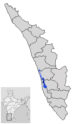
The Pamba River (also called Pampa River) is the longest river in the Indian state of Kerala after Periyar and Bharathappuzha, and the longest river in the erstwhile former princely state of Travancore. Sabarimala temple dedicated to Lord Ayyappa is located on the banks of the river Pamba. The river is also known as 'Dakshina Bhageerathi'. During ancient times it was called 'River Baris' and jordan of malankara The River Pamba enriches the lands of Pathanamthitta District and the Kuttanad area of Alappuzha District and few areas of Kottayam Course The Pamba originates at Pulachimalai hill in the Peerumedu plateau in the Western Ghats at an altitude of . Starting from the Idukki district and traversing a distance of through Pathanamthitta and Alappuzha districts, the river joins the Arabian Sea through a number of channels. The basin extends over an area of with the entire catchment area within Kerala state. The basin is bounded on the east by Western Ghats and on the west ... [...More Info...] [...Related Items...] OR: [Wikipedia] [Google] [Baidu] |
Vembanad Lake
Vembanad is the longest lake in India, as well as the largest lake in the state of Kerala. The lake has an area of 230 square kilometers and a maximum length of 96.5 km. Spanning several districts in the state of Kerala, it is known as Vembanadu Lake in Kottayam, Vaikom, Changanassery, Punnamada Lake in Alappuzha, Punnappra, Kuttanadu and Kochi Lake in Kochi. Several groups of small islands including Vypin, Mulavukad, Maradu, Udayamperoor, Vallarpadam, Willingdon Island are located in the Kochi Lake portion. Kochi Port is built around the Willingdon Island and the Vallarpadam island. Kuttanad, also known as ''The Rice Bowl of Kerala'', has the lowest altitude in India, and is also one of the few places in world where cultivation takes place below sea level. Kuttanad lies on the southern portion of Vembanad. The Nehru Trophy Boat Race is conducted in a portion of the lake. High levels of pollution have been noticed at certain hotspots of the Vembanad backwaters. The G ... [...More Info...] [...Related Items...] OR: [Wikipedia] [Google] [Baidu] |
Achankovil River
Achankovil is a 128 km long west flowing river in Kerala, India, which flows through Kollam, Pathanamthitta, and Alappuzha districts. The river drains vast tract of fertile plains of Upper Kuttanad in the Alappuzha and Pathanamthitta districts. It also sustains numerous urban settlements along its course such as Konni, Pathanamthitta, Pandalam, Mavelikkara etc. Course The river has its origin in the peak '' Devar Mala'' of the Western Ghats situated in the Konni Reserve Forest. Rivers like Rishimala, Pashukidamettu and Ramakkaltheri form the major tributaries of the Achenkovil river. It flows south west from its origin and enters Kollam district near Achencovil village. Then the river switches its course towards north west and flows almost 20 kms through Kollam district before re-entering Pathanamthitta district near Kalleli. Later it flows through the hilly towns of Konni, Kumbazha, Mylapra, Konnithazham, Vettoor, Pathanamthitta, Pramadam, Vallikode and enters into t ... [...More Info...] [...Related Items...] OR: [Wikipedia] [Google] [Baidu] |
Puthencavu
Puthencavu is a village in Alappuzha District of Kerala, India, located 2 km east of Chengannur along the southern bank of the river Pamba. The village is around 2 km from Arattupuzha, and can be easily accessed from Chengannur and Arattupuzha. Education Metropolitan Higher Secondary School, run by the Catholicate and MD Schools Corporate Management of the Malakara Orthodox Syrian Church is located at Puthencavu. Transportation Chengannur Railway Station is the nearest railhead, and Cochin International Airport the nearest airport. The Century Multispeciality Hospital is located very near to Puthencavu Junction. Structures The 218-year-old Puthencavu St Mary's Orthodox Church is located in the village. The remains of three leaders of the Malankara Sabha, Mar Thoma VI, Mar Thoma VIII & Geevarghese Mar Philoxenos are interred in the church. Notable people Mahakavi Puthencavu Mathan Tharakan hails from this village and has made significant contributions to th ... [...More Info...] [...Related Items...] OR: [Wikipedia] [Google] [Baidu] |
Edanad
Edanad is a village in Alappuzha district in the state of Kerala, India India, officially the Republic of India (Hindi: ), is a country in South Asia. It is the seventh-largest country by area, the second-most populous country, and the most populous democracy in the world. Bounded by the Indian Ocean on the so .... References Villages in Alappuzha district {{Alappuzha-geo-stub ... [...More Info...] [...Related Items...] OR: [Wikipedia] [Google] [Baidu] |
Arattupuzha
Arattupuzha is a cultural village in Thrissur district of Kerala in South India South India, approximately South of the town of Thrissur. Located on the banks of the Karuvannur river, Arattupuzha is home to the annual Arattupuzha Pooram Arattupuzha Pooram is an Indian temple festival held at the Arattupuzha Temple in Arattupuzha, Thrissur district of Kerala. Visitors from nearby and far off places reach the village of Arattupuzha during the festival days. The pinnacle of the ... that stages the grand spectacle of numerous caparisoned elephants lined up in a row to the accompaniment of ethnic percussion concerts. Firework displays are also part of the celebration. The Arattupuzha Sastha Temple is located in Arattupuzha. The temple dates back 3000 years. References {{Thrissur Villages in Thrissur district ... [...More Info...] [...Related Items...] OR: [Wikipedia] [Google] [Baidu] |
Aranmula
Aranmula is a temple town in the state of Kerala, India. It is known as the cultural capital of Pathanamthitta district, located at a distance of around 116 km from Trivandrum, the capital of Kerala, it is situated on the banks of the river Pampa. A centre of pilgrimage from time immemorial and a trade post of eminence, when the river was the chief means of transport, it is near Kozhenchery in Pathanamthitta District. It is easily accessible from Thiruvalla & Chengannur railway stations.It is located around 14 km from Thiruvalla City Centre. Tourism Aranmula is famous for the tourist attraction 'Vallam Kali', (Snakeboat regatta). Aranmula is a global heritage site enlisted by the United Nations. It is a sacred site for the Hindus and comprises the central temple of Lord Parthasarathi with a network of temples and sacred groves around. Boat race is part of the temple festival here. The boat race is conducted on day of Uthrittathi in the month of Chingam Being a Vishnu ... [...More Info...] [...Related Items...] OR: [Wikipedia] [Google] [Baidu] |
Maramon
Maramon is a small town on the Pampa River, in Thiruvalla Sub-District & Taluk opposite to Kozhencherry in the state of Kerala, India. It is 16 km from the Thiruvalla Town headquarters, the town of Thiruvalla. Maramon Convention Maramon is famous because of the Maramon Convention, the largest Christian gathering in Asia. Maramon is said to be the birthplace of Mar Thoma Syrian Church. Villages The following villages form a part of Maramon:- #Nedumprayar #Chettimukku #Chalaikara #Thottapuzhassery. #Kurianoor #Mosco padi Maramon Transport The T. K. Road (Thiruvalla- -Kumbazha Road/SH-07) connects the town to other major towns. The nearest railway station is Thiruvalla (15 km). The nearest airports are Cochin International Airport and Trivandrum International Airport. Christian Cultural Center The town Maramon is generally recognized as center of Christian culture and influence in India. Among the churches in Maramon include the Maramon Marthoma Church, St. Ma ... [...More Info...] [...Related Items...] OR: [Wikipedia] [Google] [Baidu] |
Kozhencherry
Kozhencherry ( ml, കോഴഞ്ചേരി) is a census town in Pathanamthitta district of Central Travancore region (South Central Kerala) in Kerala state, India. census, the population was 433,357 people in 92,825 households. History Kozhencherry is situated in the central Travancore and in the centre of Pathanamthitta District. It is on the bank of the Holy river Pampa (it descends from Sabarimala) and blessed by hills and green valleys. It is a very beautiful place. The history of Kozhencherry is very closely related to the history of the Central Travancore State. Kozhencherry was one among the five major towns in the earstwhile Travancore. It is model of communal harmony. Kozhencherry is a very fertile land and cultivating plantations, paddy, tapioca, coconut, rubber, pepper, sugar cane, vegetables, spices etc. From Kozhencherry market goods were marketed to Kochi and Alapuzha through the river Pampa in big boats in olden days. In the year 1869 at the time of the rule o ... [...More Info...] [...Related Items...] OR: [Wikipedia] [Google] [Baidu] |
Keezhukara
Keezhukara, a small village in Pathanamthitta district, is about 135 km from Thiruvanandapuram, capital city of Kerala, India. It is on latitude 9.349 N and longitude 76.705 E. Pampa River is on the north and west. Kozhencherry is in the south and Melukara in the east. The Interior is hilly but the riverine land is flat, fertile and arable. The population of Keezhukara in 2008 was 1211 in 292 households.Kozhencherry Panchayat Reports History In olden days, Keezhukara was a jungle where wild animals roamed freely around. The last wild animal to leave was the jackals whose howling could be heard even in the fifties of the last century. There had been no permanent settlements. A footpath parallel to the river went all the way from Niranam to Nilakkal. Remnants of that path are still visible in Keezhukara. This path had been used to bring jungle produce to the riverside for transporting by country crafts to Niranam, the nearest port of trade at that time. The common items bro ... [...More Info...] [...Related Items...] OR: [Wikipedia] [Google] [Baidu] |
Cherukole
Cherukole is a village in Pathanamthitta district in the state of Kerala, India. Demographics India census, Cherukole had a population of 13,048 with 6,200 males and 6,848 females. See also * Ranni * Keekozhur * Pathanamthitta district Pathanamthitta District (), is one of the 14 districts in the Indian state of Kerala. The district headquarters is in the town of Pathanamthitta. There are four municipalities in Pathanamthitta: Adoor, Pandalam, Pathanamthitta and Thiruval ... References Villages in Pathanamthitta district {{Pathanamthitta-geo-stub ... [...More Info...] [...Related Items...] OR: [Wikipedia] [Google] [Baidu] |
Ayroor
Ayroor (also spelled Ayiroor) is a village Near Thiruvalla,located in the western part of Ranni taluk, in the Pathanamthitta district in Kerala state, India. It is bordered by hills and located near the Western Ghats. Ayroor was previously part of Thiruvalla taluk in Alleppey district and is considered part of the Edanadu region in Kerala. The Pamba River flows on the southern side of the village. Tourism The Pamba River and the surrounding hills make Ayiroor a picturesque location in central Travancore. Residents of Ayiroor cultivate coconut, rubber, cocoa, tapioca, plantains, cinnamon, pepper, nutmeg, vanilla, rambutan and other crops, making the per capita income of the residents higher than the state average. The nearest airports are the Cochin International Airport, located 127 kilometers away, and Trivandrum International Airport, 120 kilometers away. One of the highlights of Ayroor is the ''Cherukolpuzha Hindu Parishad'', a religious festival that is held for a w ... [...More Info...] [...Related Items...] OR: [Wikipedia] [Google] [Baidu] |
Ranni, Kerala
Ranni or Ranny is a town in the Pathanamthitta district of Kerala, India, and the 16th largest ''taluk'' (administrative division) in Kerala, located on both sides of the Pamba River.It Is Located 30 km From Thiruvalla Railway Station & NH 183 in Thiruvalla.Buses Ply Every 5 minutes From Thiruvalla To Ranni & Vice Versa Etymology The name ''Ranni'' is derived from a word in Malayalam which means "Queen", or ''Rani''. The town is known as "The Queen of the Eastern Hill Lands" (മലനാടിന്റെ റാണി). History The history of Ranni can be traced back 5000 years to the early settlement of Adi Dravidans around Sabarimala and Nilakkal. The temple at Sabarimala dates back 2000 years. The deity's sitting posture and resemblance of the prayer 'Sharanam vili' to "Buddham Sharanam / Sangam Sharanam" points to the area's Buddhist past. The word 'Ayya' is a Buddhist Pali word that means Lord/God. An ancient trade route used to pass through Nilackal between Kerala a ... [...More Info...] [...Related Items...] OR: [Wikipedia] [Google] [Baidu] |


