|
Ridge Route
The Ridge Route, officially the Castaic–Tejon Route, was a two-lane highway between Los Angeles County and Kern County, California. Opened in 1915 and paved with concrete between 1917 and 1921, the road was the first paved highway directly linking the Los Angeles Basin with the San Joaquin Valley (southern Central Valley) over the Tejon Pass and the rugged Sierra Pelona Mountains ridge south of Gorman. Much of the old road runs through the Angeles National Forest, and passes many historical landmarks, including the National Forest Inn, Reservoir Summit, Kelly's Half Way Inn, Tumble Inn, and Sandberg's Summit Hotel. North of the forest, the Ridge Route passed through Deadman's Curve before ending at Grapevine. The road was bypassed by the three-lane Ridge Route Alternate, then U.S. Route 99 (US 99), to handle increased traffic and remove curves; the Alternate in Los Angeles County was completed in 1933, and Kern County line to Grapevine in 1936. The four-lane US ... [...More Info...] [...Related Items...] OR: [Wikipedia] [Google] [Baidu] |
Castaic Junction, California
Castaic Junction is an unincorporated community located in Los Angeles County, California. It is located at the crossroads of Interstate 5 and State Route 126 near the confluence of Castaic Creek and the Santa Clara River. Places in Castaic Junction carry a Valencia zip code (91355), and it is adjacent to the City of Santa Clarita. Six Flags Magic Mountain theme park is just south of the junction. History Castaic Junction was the official southern end of the Ridge Route. The name dates to 1887, before highways were built, when a railroad siding was set up at the junction. The community had an Art Deco− Moderne style train depot, serving the railroad line that ran along the Santa Clara River between Saugus and Piru. The depot was demolished around 1990. Just beyond the north end of the Magic Mountain parking lot is the site of the adobe ranch house for the historic Rancho San Francisco, a Mexican land grant that encompassed the Santa Clarita Valley from Piru to Canyo ... [...More Info...] [...Related Items...] OR: [Wikipedia] [Google] [Baidu] |
National Register Of Historic Places
The National Register of Historic Places (NRHP) is the United States federal government's official list of districts, sites, buildings, structures and objects deemed worthy of preservation for their historical significance or "great artistic value". A property listed in the National Register, or located within a National Register Historic District, may qualify for tax incentives derived from the total value of expenses incurred in preserving the property. The passage of the National Historic Preservation Act (NHPA) in 1966 established the National Register and the process for adding properties to it. Of the more than one and a half million properties on the National Register, 95,000 are listed individually. The remainder are contributing resources within historic districts. For most of its history, the National Register has been administered by the National Park Service (NPS), an agency within the U.S. Department of the Interior. Its goals are to help property owners and inte ... [...More Info...] [...Related Items...] OR: [Wikipedia] [Google] [Baidu] |
Clapboard (architecture)
Clapboard (), also called bevel siding, lap siding, and weatherboard, with regional variation in the definition of these terms, is wooden siding of a building in the form of horizontal boards, often overlapping. ''Clapboard'' in modern American usage is a word for long, thin boards used to cover walls and (formerly) roofs of buildings. Historically, it has also been called ''clawboard'' and ''cloboard''. In the United Kingdom, Australia and New Zealand, the term ''weatherboard'' is always used. An older meaning of "clapboard" is small split pieces of oak imported from Germany for use as barrel staves, and the name is a partial translation (from , "to fit") of Middle Dutch and related to German . Types Riven Clapboards were originally riven radially producing triangular or "feather-edged" sections, attached thin side up and overlapped thick over thin to shed water. [...More Info...] [...Related Items...] OR: [Wikipedia] [Google] [Baidu] |
Ridge Route National Forest Inn Steps
A ridge or a mountain ridge is a geographical feature consisting of a chain of mountains or hills that form a continuous elevated crest for an extended distance. The sides of the ridge slope away from the narrow top on either side. The lines along the crest formed by the highest points, with the terrain dropping down on either side, are called the ridgelines. Ridges are usually termed hills or mountains as well, depending on size. Smaller ridges, especially those leaving a larger ridge, are often referred to as spurs. Types There are several main types of ridges: ;Dendritic ridge: In typical dissected plateau terrain, the stream drainage valleys will leave intervening ridges. These are by far the most common ridges. These ridges usually represent slightly more erosion resistant rock, but not always – they often remain because there were more joints where the valleys formed or other chance occurrences. This type of ridge is generally somewhat random in orientation, often ... [...More Info...] [...Related Items...] OR: [Wikipedia] [Google] [Baidu] |
Los Angeles Times
The ''Los Angeles Times'' (abbreviated as ''LA Times'') is a daily newspaper that started publishing in Los Angeles in 1881. Based in the LA-adjacent suburb of El Segundo since 2018, it is the sixth-largest newspaper by circulation in the United States. The publication has won more than 40 Pulitzer Prizes. It is owned by Patrick Soon-Shiong and published by the Times Mirror Company. The newspaper’s coverage emphasizes California and especially Southern California stories. In the 19th century, the paper developed a reputation for civic boosterism and opposition to labor unions, the latter of which led to the bombing of its headquarters in 1910. The paper's profile grew substantially in the 1960s under publisher Otis Chandler, who adopted a more national focus. In recent decades the paper's readership has declined, and it has been beset by a series of ownership changes, staff reductions, and other controversies. In January 2018, the paper's staff voted to unionize and final ... [...More Info...] [...Related Items...] OR: [Wikipedia] [Google] [Baidu] |
Templin Highway
Templin Highway is the completed part of a two-lane road project in Los Angeles County, California. The road connects Interstate 5 and the old Golden State Highway with the north end of Castaic Lake. The name is commonly misapplied to the old Golden State Highway, which runs north into Piru Gorge. Proposal Originally named Warm Springs Road, it was renamed in 1967 after county highway commissioner Newton H. Templin, who had promoted the road's construction. Until plans were canceled in 1980, the road was to continue east; a 1958 plan shows it extending to San Francisquito Canyon Road as an expressway, Metropolitan Transportation Engineering BoardMaster Plan of Freeways and Expressways adopted February 28, 1958 and by 1975 it was to connect with Spunky Canyon Road near the Bouquet Reservoir. Use in media For the filming of "Mr. Monk Gets Stuck in Traffic", an episode of the TV series ''Monk'', the crew turned Templin Highway into a freeway by constructing a median barrier out of ... [...More Info...] [...Related Items...] OR: [Wikipedia] [Google] [Baidu] |
Runaway Truck
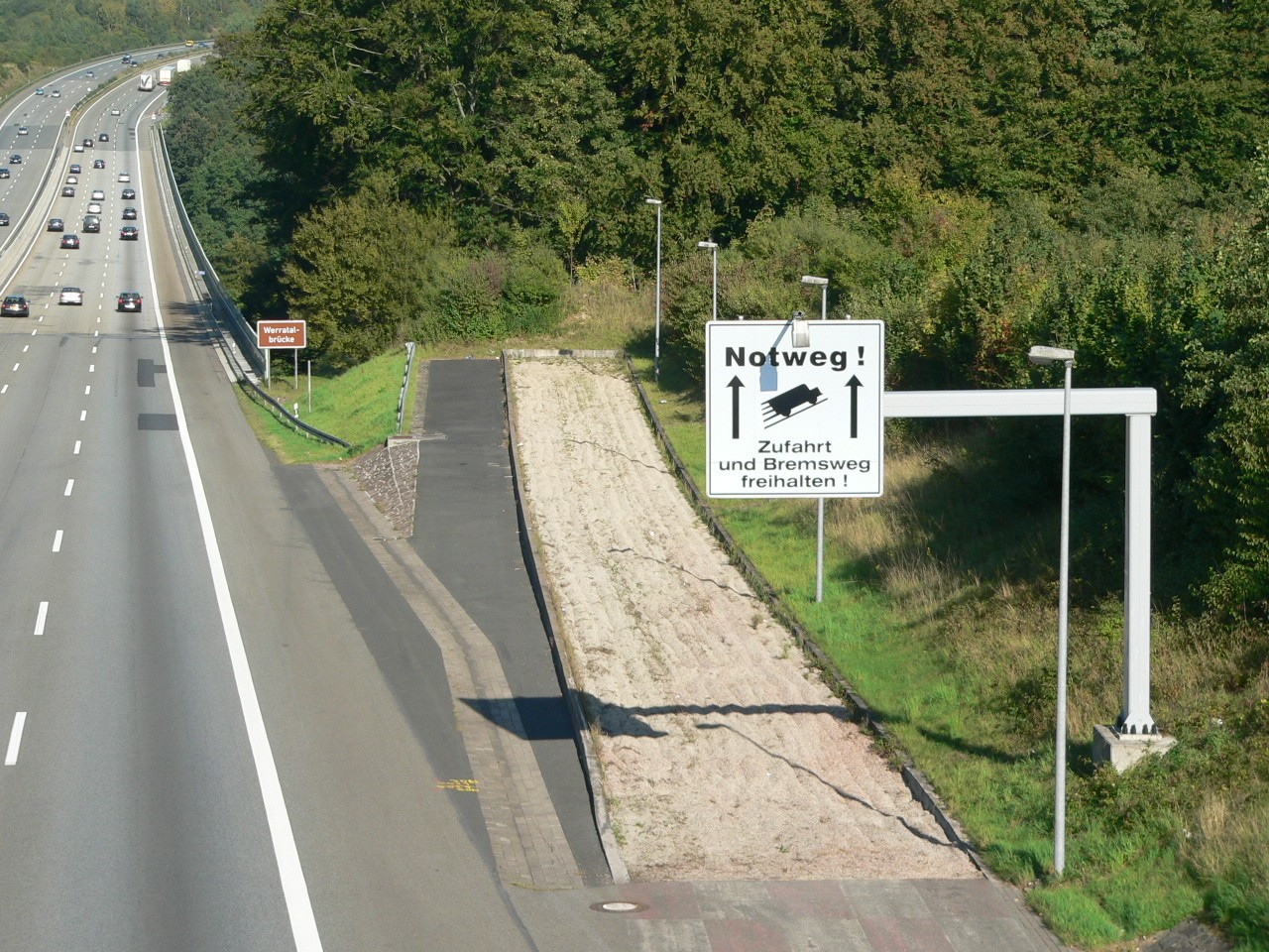
A runaway truck ramp, runaway truck lane, escape lane, emergency escape ramp, or truck arrester bed is a traffic device that enables vehicles which are having braking problems to safely stop. It is typically a long, sand- or gravel-filled lane connected to a steep downhill grade section of a main road, and is designed to accommodate large trucks or buses. It allows a moving vehicle's kinetic energy to be dissipated gradually in a controlled and relatively harmless way, helping the operator stop it safely. Design Emergency escape ramps are usually located in mountainous areas which cause high construction costs and present difficult site selection. A ramp may cost US$1 million. Designs include: *''Arrester bed'': a gravel-filled ramp adjacent to the road that uses rolling resistance to stop the vehicle. The required length of the bed depends on the mass and speed of the vehicle, the grade of the arrester bed, and the rolling resistance provided by the gravel. *''Gravity escape ra ... [...More Info...] [...Related Items...] OR: [Wikipedia] [Google] [Baidu] |
Weldon Canyon
Weldon Canyon is the name of two canyons in California. Los Angeles County In Los Angeles County, California, United States, at , Weldon is a canyon through which Interstate 5 passes. The Old Road, now paralleled by I-5, opened on May 28, 1930, through the canyon as a bypass of the 1910 Newhall Tunnel. This original road through the canyon was 20 feet (6 m) wide and made of concrete. The canyon is named after Arthur Weldon, who helped build the Southern Pacific Railroad's nearby San Fernando Tunnel.Harrison Irving Scott, Ridge Route: The Road That United California, pp. 60-61, third printing, 2003, Solano County In Solano County, California, at , Weldon is the name sometimes given to a canyon west of Vacaville, California. Weldon canyon is mentioned in the diaries of Willis Linn Jepson Willis Linn Jepson (August 19, 1867 – November 7, 1946) was an early California botanist, conservationist, and writer. Career Born at Little Oak Ranch near Vacaville, California, Je ... [...More Info...] [...Related Items...] OR: [Wikipedia] [Google] [Baidu] |
Newhall, Santa Clarita, California
Newhall is the southernmost and oldest community in the city of Santa Clarita, California. Prior to the 1987 consolidation of Canyon Country, Saugus, Newhall, and Valencia into the city of Santa Clarita, it was an unincorporated area. It was the first permanent town in the Santa Clarita Valley. History The Tataviam village of Tochonanga was located at the area where Newhall stands today. Fifty villagers were brought to Mission San Fernando from 1797 to 1811. Descendants of the village continued to live in the Newhall area. Named after businessman Henry Mayo Newhall, Newhall is home to the William S. Hart County Park, featuring tours of the famous silent movie maker's mansion. Newhall is also home to the Pioneer Oil Refinery (California Historical Landmark, No. 172), the oldest surviving oil refinery in the world and the first commercially successful refinery in California. Over the years, Newhall has been the location for many movies, including '' Suddenly'' (1954) and Disne ... [...More Info...] [...Related Items...] OR: [Wikipedia] [Google] [Baidu] |
Santa Clara River (California)
The Santa Clara River ( es, Río Santa Clara) is an longU.S. Geological Survey. National Hydrography Dataset high-resolution flowline dataThe National Map accessed March 16, 2011 river in Southern California. It drains parts of four ranges in the Transverse Ranges System north and northwest of Los Angeles, then flows west onto the Oxnard Plain and into the Santa Barbara Channel of the Pacific Ocean. The watershed has provided habitat for a wide array of native plants and animals and has historically supplied humans with water, fish, and fertile farmland. The northern portion of the watershed was home to the Tataviam people while the southern portion was occupied by the Chumash people. Much of the Santa Clara River Valley is used for agriculture which has limited the use of structural levees to separate the natural floodplain from the river. Although it is one of the least altered rivers in Southern California, some levees exist where the river flows through areas of significant ... [...More Info...] [...Related Items...] OR: [Wikipedia] [Google] [Baidu] |
.jpg)


.jpg)
