|
Reshetnikovo Railway Station
Reshetnikovo (russian: Решетниково) is the name of several inhabited localities in Russia. Modern localities ;Urban localities *Reshetnikovo, Moscow Oblast, a work settlement in Klinsky District of Moscow Oblast; ;Rural localities *Reshetnikovo, Chuvash Republic, a village in Attikovskoye Rural Settlement of Kozlovsky District in the Chuvash Republic *Reshetnikovo, Kirov Oblast, a village in Rodyginsky Rural Okrug of Sovetsky District in Kirov Oblast; *Reshetnikovo, Leningrad Oblast, a village in Pervomayskoye Settlement Municipal Formation of Vyborgsky District in Leningrad Oblast; *Reshetnikovo, Omsk Oblast, a village in Takmyksky Rural Okrug of Bolsherechensky District in Omsk Oblast; *Reshetnikovo, Bezhanitsky District, Pskov Oblast, a village in Bezhanitsky District of Pskov Oblast *Reshetnikovo, Opochetsky District, Pskov Oblast, a village in Opochetsky District of Pskov Oblast *Reshetnikovo, Velikoluksky District, Pskov Oblast, a village in Velikoluks ... [...More Info...] [...Related Items...] OR: [Wikipedia] [Google] [Baidu] |
Types Of Inhabited Localities In Russia
The classification system of inhabited localities in Russia and some other post-Soviet states has certain peculiarities compared with those in other countries. Classes During the Soviet time, each of the republics of the Soviet Union, including the Russian SFSR, had its own legislative documents dealing with classification of inhabited localities. After the dissolution of the Soviet Union, the task of developing and maintaining such classification in Russia was delegated to the federal subjects.Articles 71 and 72 of the Constitution of Russia do not name issues of the administrative and territorial structure among the tasks handled on the federal level or jointly with the governments of the federal subjects. As such, all federal subjects pass their own laws establishing the system of the administrative-territorial divisions on their territories. While currently there are certain peculiarities to classifications used in many federal subjects, they are all still largely ba ... [...More Info...] [...Related Items...] OR: [Wikipedia] [Google] [Baidu] |
Pskov Oblast
Pskov Oblast (russian: Пско́вская о́бласть, ') is a federal subjects of Russia, federal subject of Russia (an oblast), located in the west of the country. Its administrative center is the types of inhabited localities in Russia, city of Pskov. As of the Russian Census (2010), 2010 Census, its population was 673,423. Geography Pskov Oblast is the westernmost federal subjects of Russia, federal subject of contiguous Russia (Kaliningrad Oblast, while located further to the west, is an enclave and exclave, exclave).1september.ru. Д. В. Заяц (D. V. Zayats).Псковская область (''Pskov Oblast''). It borders with Leningrad Oblast in the north, Novgorod Oblast in the east, Tver Oblast, Tver and Smolensk Oblasts in the southeast, Vitebsk Region, Vitebsk Oblast of Belarus in the south, and with the counties of Latvia (Alūksne Municipality, Balvi Municipality, and Ludza Municipality) and Estonia (Võru County) in the west. In the northwest, Pskov O ... [...More Info...] [...Related Items...] OR: [Wikipedia] [Google] [Baidu] |
Town Of District Significance
Town of district significance is an administrative division of a district in a federal subject of Russia. It is equal in status to a selsoviet or an urban-type settlement of district significance, but is organized around a town (as opposed to a rural locality or an urban-type settlement); often with surrounding rural territories. Background Prior to the adoption of the 1993 Constitution of Russia, this type of administrative division was defined on the whole territory of the Russian SFSR as an inhabited locality which serves as a cultural and an industrial center of a district and has a population of at least 12,000, of which at least 80% are workers, public servants, and the members of their families.Иванец Г.И., Калинский И.В., Червонюк В.И. Конституционное право России: энциклопедический словарь / Под общей ред. В.И. Червонюка. — М.: Юрид. лит., 2002. — 43 ... [...More Info...] [...Related Items...] OR: [Wikipedia] [Google] [Baidu] |
Vologodsky District
Vologodsky District (russian: Волого́дский райо́н) is an administrativeLaw #371-OZ and municipalLaw #1112-OZ district (raion), one of the twenty-six in Vologda Oblast, Russia. It is located in the center of the oblast and borders with Ust-Kubinsky and Sokolsky Districts in the northeast, Mezhdurechensky District in the east, Gryazovetsky District in the southeast, Poshekhonsky District of Yaroslavl Oblast in the southwest, Sheksninsky District in the west, and with Kirillovsky District in the northwest. The area of the district is . Its administrative center is the city of Vologda (which is not administratively a part of the district). Population: 50,956 ( 2002 Census); As of 2010, Vologodsky District was the most populous among all the districts of Vologda Oblast. Geography The district is elongated from northwest to southeast with Lake Kubenskoye, one of the biggest lakes in Vologda Oblast, forming its northeastern border. The lake is shared between Vologod ... [...More Info...] [...Related Items...] OR: [Wikipedia] [Google] [Baidu] |
Sokolsky District, Vologda Oblast
Sokolsky District (russian: Со́кольский райо́н) is an administrativeLaw #371-OZ and municipalLaw #1121-OZ district (raion), one of the twenty-six in Vologda Oblast, Russia. It is located in the center of the oblast and borders with Kharovsky and Syamzhensky Districts in the north, Totemsky District in the east, Mezhdurechensky District in the south, Vologodsky District in the southeast, and with Ust-Kubinsky District in the northwest. The area of the district is . Its administrative center is the town of Sokol (which is not administratively a part of the district). Population: 14,951 ( 2002 Census); Geography The district is elongated from west to east and lies in the basin of the Sukhona River. The westernmost part of the district is on the shore of Lake Kubenskoye. The source of the Sukhona is located in Ust-Kubinsky District, but a relatively short stretch of the river course runs through the district downstream of the source. In particular, the town ... [...More Info...] [...Related Items...] OR: [Wikipedia] [Google] [Baidu] |
Vologda Oblast
Vologda Oblast ( rus, Вологодская область, p=vəlɐˈɡotskəjə ˈobləsʲtʲ, r=Vologodskaya oblast, ) is a federal subject of Russia (an oblast). Its administrative center is Vologda. The Oblast has a population of 1,202,444 ( 2010 Census). The largest city is Cherepovets, the home of the Severstal metallurgical plant, the largest industrial enterprise in the oblast. Vologda Oblast is rich in historic monuments, such as the Kirillo-Belozersky Monastery, Ferapontov Monastery (a World Heritage Site) with the frescoes of Dionisius, medieval towns of Velikiy Ustyug and Belozersk, and baroque churches of Totma and Ustyuzhna. Large reserves of wood and fresh water are the main natural resources. History The area of Vologda Oblast was settled by Finnic peoples in prehistory, and most of the toponyms in the region are in fact Finnic. Vepsians, who still live in the west of the oblast, are the descendants of that population. Subsequently, the area was colonized ... [...More Info...] [...Related Items...] OR: [Wikipedia] [Google] [Baidu] |
Kichmengsko-Gorodetsky District
Kichmengsko-Gorodetsky District (russian: Ки́чменгско-Городе́цкий райо́н) is an administrativeLaw #371-OZ and municipalLaw #1117-OZ district (raion), one of the twenty-six in Vologda Oblast, Russia. It is located in the east of the oblast and borders with Velikoustyugsky District in the north, Podosinovsky District of Kirov Oblast in the northeast, Oparinsky District of Kirov Oblast in the southeast, Vokhomsky District of Kostroma Oblast in the south, Nikolsky and Babushkinsky Districts in the southwest, and with Nyuksensky District in the northwest. The area of the district is . Its administrative center is the rural locality (a '' selo'') of Kichmengsky Gorodok.Resolution #178 District's population: 22,187 ( 2002 Census); The population of Kichmengsky Gorodok accounts for 34.9% of the district's total population. Geography Almost all of the district belongs to the basin of the Yug and two of its main tributaries, the Kichmenga (left) and the ... [...More Info...] [...Related Items...] OR: [Wikipedia] [Google] [Baidu] |
Udmurt Republic
Udmurtia (russian: Удму́ртия, r=Udmúrtiya, p=ʊˈdmurtʲɪjə; udm, Удмуртия, ''Udmurtija''), or the Udmurt Republic (russian: Удмуртская Республика, udm, Удмурт Республика, Удмурт Элькун, ''Udmurt Respublika'', ''Udmurt Eľkun''), is a federal subject of Russia (a republic) in Eastern Europe, within the Volga Federal District. Its capital is the city of Izhevsk. Name The name ''Udmurt'' comes from ('meadow people'), where the first part represents the Permic root or ('meadow, glade, turf, greenery'). This is supported by a document dated 1557, in which the Udmurts are referred to as ('meadow people'), alongside the traditional Russian name . The second part means 'person' (cf. Komi , Mari ). It is probably an early borrowing from a Scythian language: or ('person, man'; cf. Urdu ), which is thought to have been borrowed from the Indo-Aryan term ('man, mortal, one who is bound to die'. cf. Old Indic ... [...More Info...] [...Related Items...] OR: [Wikipedia] [Google] [Baidu] |
Mozhginsky District
Mozhginsky District (russian: Можги́нский райо́н; udm, Можга ёрос, ''Možga joros'') is an administrativeConstitution of the Udmurt Republic and municipalLaw #41-RZ district (raion), one of the twenty-five in the Udmurt Republic, Russia. It is located in the southwest of the republic. The area of the district is . Its administrative center is the town of Mozhga (which is not administratively a part of the district).Law #46-RZ Population: 30,358 ( 2002 Census); Geography The Vala River is the main river in the district. Administrative and municipal status Within the framework of administrative divisions, Mozhginsky District is one of the twenty-five in the republic. The town of Mozhga serves as its administrative center, despite being incorporated separately as a town of republic significance—an administrative unit with the status equal to that of the districts. As a municipal division, the district is incorporated as Mozhginsky Municipal Distri ... [...More Info...] [...Related Items...] OR: [Wikipedia] [Google] [Baidu] |
Novoduginsky District
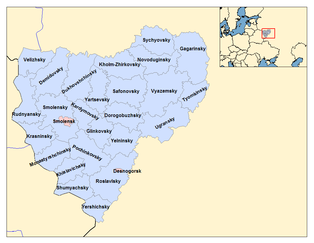
Novoduginsky District (russian: Новодугинский райо́н) is an administrativeResolution #261 and municipalLaw #109-z district (raion), one of the twenty-five in Smolensk Oblast, Russia. It is located in the northeast of the oblast. The area of the district is . Its administrative center is the rural locality In general, a rural area or a countryside is a geographic area that is located outside towns and cities. Typical rural areas have a low population density and small settlements. Agricultural areas and areas with forestry typically are describ ... (a '' selo'') of Novodugino. Population: 10,477 ( 2010 Census); The population of Novodugino accounts for 36.6% of the district's total population. References Notes Sources * * {{Use mdy dates, date=January 2013 Districts of Smolensk Oblast ... [...More Info...] [...Related Items...] OR: [Wikipedia] [Google] [Baidu] |
Smolensk Oblast
Smolensk Oblast (russian: Смоле́нская о́бласть, ''Smolenskaya oblast''; informal name — ''Smolenschina'' (russian: Смоле́нщина)) is a federal subject of Russia (an oblast). Its administrative centre is the city of Smolensk. As of the 2010 Census, its population was 985,537. Geography The oblast was founded on 27 September 1937.Исполнительный комитет Смоленского областного совета народных депутатов. Государственный архив Смоленской области. "Административно-территориальное устройство Смоленской области. Справочник", изд. "Московский рабочий", Москва 1981. Стр. 8 It borders Pskov Oblast in the north, Tver Oblast in the northeast, Moscow Oblast in the east, Kaluga Oblast in south, Bryansk Oblast in the southwest, and Mogilev and Vitebsk Oblast ... [...More Info...] [...Related Items...] OR: [Wikipedia] [Google] [Baidu] |


