|
Rapid Creek (South Dakota)
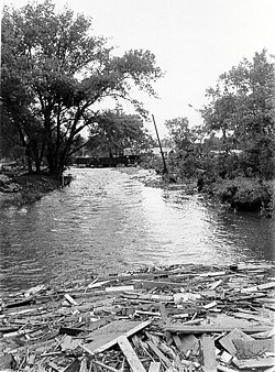
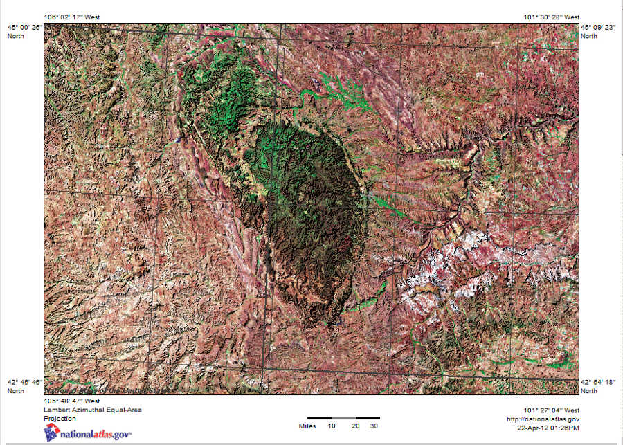
Rapid Creek is a tributary of the Cheyenne River, approximately 86 mi (138 km) long, in South Dakota in the United States. The creek's name comes from the Sioux Indians of the area, for the many rapids in the stream. Course It rises in southwestern South Dakota, in the Black Hills National Forest in the Black Hills in Pennington County. It flows east, is joined by Castle Creek, past Silver City and through the Pactola Reservoir. Emerging from the Black Hills, it flows through Rapid City, past Farmingdale, and joins the Cheyenne River approximately 13 mi (21 km) southwest of Wasta. 1972 flood The Rapid Creek is most noted for the Black Hills flood of 1972, in which 238 people perished in Rapid City and in the Black Hills. Since the flood, a flood plain has been established throughout the city making development along the banks inconsiderable. See also *List of rivers of South Dakota This is a list of rivers in the state of South Dakota in the Un ... [...More Info...] [...Related Items...] OR: [Wikipedia] [Google] [Baidu] |
South Dakota
South Dakota (; Sioux language, Sioux: , ) is a U.S. state in the West North Central states, North Central region of the United States. It is also part of the Great Plains. South Dakota is named after the Lakota people, Lakota and Dakota people, Dakota Sioux Native Americans in the United States, Native American tribes, who comprise a large portion of the population with nine Indian reservation, reservations currently in the state and have historically dominated the territory. South Dakota is the List of U.S. states and territories by area, seventeenth largest by area, but the List of U.S. states and territories by population, 5th least populous, and the List of U.S. states and territories by population density, 5th least densely populated of the List of U.S. states, 50 United States. As the southern part of the former Dakota Territory, South Dakota became a state on November 2, 1889, simultaneously with North Dakota. They are the 39th and 40th states admitted to the union; Pr ... [...More Info...] [...Related Items...] OR: [Wikipedia] [Google] [Baidu] |
Castle Creek (South Dakota)
Castle Creek is a tributary of Rapid Creek (South Dakota), Rapid Creek, approximately 14 mi (23 km) long, in western South Dakota in the United States. It rises out of Deerfield Reservoir, in the Black Hills in Pennington County, South Dakota, Pennington County approximately 15 mi (24 km) NNW of Custer, South Dakota, Custer. It flows north and east, joining Rapid Creek approximately 4 mi (6.4 km) west of Silver City, South Dakota, Silver City. Castle Creek received its name on account of castle-like rock formations of the nearby canyon. See also *List of rivers of South Dakota References Rivers of South Dakota Black Hills Rivers of Pennington County, South Dakota {{SouthDakota-river-stub ... [...More Info...] [...Related Items...] OR: [Wikipedia] [Google] [Baidu] |
List Of Rivers Of South Dakota
This is a list of rivers in the state of South Dakota in the United States. By tributary Minnesota River watershed *Little Minnesota River ** Jorgenson River * Whetstone River *North Fork Yellow Bank River *South Fork Yellow Bank River *West Branch Lac qui Parle River Missouri River * Little Missouri River * Grand River **Black Horse Butte Creek **Cedar Boy Creek **Cottonwood Creek **Cottonwood Creek **Cyclone Creek **Dirt Lodge Creek ***Little Soldier Creek **Firesteel Creek **Flat Creek ***East Flat Creek **High Bank Creek **Hump Creek **Lodgepole Creek **Louse Creek **Meadow Creek ** North Fork Grand River ***Billy Young Creek ***Buffalo Creek ***Crooked Creek ****Petes Creek ***Deer Creek ***Horse Creek ***Lone Tree Creek ***Slick Creek **Plum Creek **Rock Creek **Soldier Creek **Stink Creek ***Iron Dog Creek ** South Fork Grand River ***Bar H Creek ***Bog Creek ***Boxelder Creek ***Box Spring Creek ***Brush Creek ***Bull Creek ***Butcher Creek ***Clarks Fork Creek ***Coal Cr ... [...More Info...] [...Related Items...] OR: [Wikipedia] [Google] [Baidu] |
Flood Plain
A floodplain or flood plain or bottomlands is an area of land adjacent to a river which stretches from the banks of its channel to the base of the enclosing valley walls, and which experiences flooding during periods of high discharge.Goudie, A. S., 2004, ''Encyclopedia of Geomorphology'', vol. 1. Routledge, New York. The soils usually consist of clays, silts, sands, and gravels deposited during floods. Because the regular flooding of floodplains can deposit nutrients and water, floodplains frequently have high soil fertility; some important agricultural regions, such as the Mississippi river basin and the Nile, rely heavily on the flood plains. Agricultural regions as well as urban areas have developed near or on floodplains to take advantage of the rich soil and fresh water. However, the risk of flooding has led to increasing efforts to control flooding. Formation Most floodplains are formed by deposition on the inside of river meanders and by overbank flow. Whereve ... [...More Info...] [...Related Items...] OR: [Wikipedia] [Google] [Baidu] |
Black Hills Flood
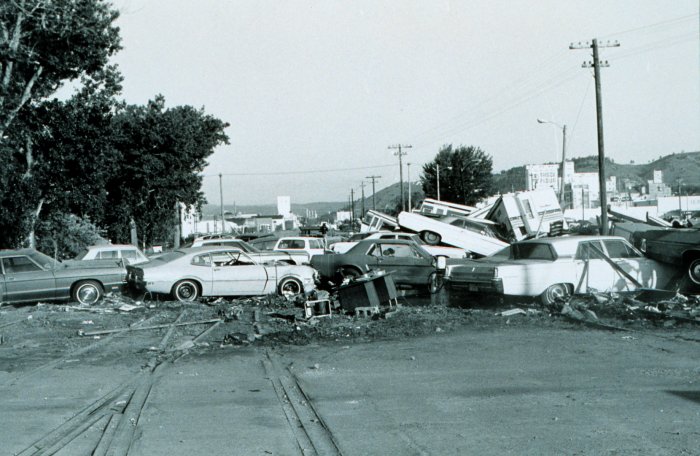
The Black Hills Flood of 1972, also known as the Rapid City Flood, was the most detrimental flood in South Dakota history, and one of the deadliest floods in U.S. history. The flood took place on June 9–10, 1972 in the Black Hills of Western South Dakota. of rain in a small area over the Black Hills caused Rapid Creek and other waterways to overflow. Severe flooding of residential and commercial properties in Rapid City occurred when Canyon Lake Dam became clogged with debris and failed in the late evening hours of June 9 resulting in 238 deaths and 3,057 injuries. Over 1,335 homes and 5,000 automobiles were destroyed. The value of property damage was estimated to be over US$160 million in 1972 dollars ($ in dollars). Flooding also occurred in Battle, Spring, Bear Butte, and Boxelder creeks. Causes A few days before the Rapid City Flood, "earlier rains had left the soil saturated, increasing the amount of runoff of the flood to come." On the afternoon of June 9, substantial ... [...More Info...] [...Related Items...] OR: [Wikipedia] [Google] [Baidu] |
Wasta, South Dakota
Wasta ''( lkt, link=no, wašté)'' is a town in Pennington County, South Dakota, United States, situated along the Cheyenne River. It had a population of 65 at the 2020 census. History A post office called Wasta has been in operation since 1907. Wasta is a name derived from the Dakota word "wašté", meaning "good". Geography Wasta is located at (44.068638, -102.445108). It sits along Interstate 90 in the western part of South Dakota. According to the United States Census Bureau, the town has a total area of , all land. Wasta has been assigned the ZIP code 57791 and the FIPS place code 69140. Climate Demographics 2010 census As of the census of 2010, there were 80 people, 36 households, and 20 families living in the town. The population density was . There were 46 housing units at an average density of . The racial makeup of the town was 100.0% White. Hispanic or Latino of any race were 1.3% of the population. There were 36 households, of which 25.0% had children under ... [...More Info...] [...Related Items...] OR: [Wikipedia] [Google] [Baidu] |
Pactola Lake
Pactola Lake is the largest and deepest reservoir in the Black Hills, located 15 miles west of Rapid City, South Dakota, United States. Constructed in 1952, the dam and waters are managed by the Bureau of Reclamation, with the surrounding land managed by the US Forest Service as part of Black Hills National Forest, which operates a visitor center located on the south side of the dam. Facilities include campgrounds, hiking trails, picnic areas, and a beach. History Pactola Dam was built in 1952 by federal authorities to provide Rapid City with a new water supply, following the related construction of Deerfield Dam in 1945. The new reservoir inundated the mining town of Pactola, and construction was completed in 1956 after the movement of more than 4.3 million cubic yards of embankment fill. Severe thunderstorms in 1972 that caused flooding in Rapid City led to dam modifications to ensure safety, with further safety modifications in 1987. Ecology Many fish live in Pactola Lak ... [...More Info...] [...Related Items...] OR: [Wikipedia] [Google] [Baidu] |
Silver City, South Dakota
Silver City is an unincorporated community in Pennington County, South Dakota, United States, outside Rapid City. It lies at the head of Pactola Lake on Rapid Creek, and is about 5 miles west of U.S. Route 385 via a paved county road. It is not tracked by the U.S. Census Bureau. History The area was first referenced by General George A. Custer who entered the Hills in 1874 and referred to the area as Elkhorn Prairie. The first settlement at Silver City was made in 1876. Silver City was a mining town for many years. It was located on the Black Hills and Western Railroad until its abandonment a few years before the construction of Pactola Dam. Today, the town is a resort area with a campground and cabins for rental. There is also a church. Additional USFS campgrounds are located nearby, and there is a walk-in trout fishing area along Rapid Creek to the west of the town. Silver City has a volunteer fire department, and a small community center in the old schoolhouse, but is now p ... [...More Info...] [...Related Items...] OR: [Wikipedia] [Google] [Baidu] |
Black Hills
The Black Hills ( lkt, Ȟe Sápa; chy, Moʼȯhta-voʼhonáaeva; hid, awaxaawi shiibisha) is an isolated mountain range rising from the Great Plains of North America in western South Dakota and extending into Wyoming, United States. Black Elk Peak (formerly known as Harney Peak), which rises to , is the range's highest summit. The Black Hills encompass the Black Hills National Forest. The name of the hills in Lakota is ', meaning “the heart of everything that is." The Black Hills are considered a holy site. The hills are so called because of their dark appearance from a distance, as they are covered in evergreen trees. Native Americans have a long history in the Black Hills and consider it a sacred site. After conquering the Cheyenne in 1776, the Lakota took the territory of the Black Hills, which became central to their culture. In 1868, the U.S. government signed the Fort Laramie Treaty of 1868, establishing the Great Sioux Reservation west of the Missouri River, and exempt ... [...More Info...] [...Related Items...] OR: [Wikipedia] [Google] [Baidu] |
Pennington County, South Dakota
Pennington County is a county in the U.S. state of South Dakota. As of the 2020 census, the population was 109,222, making it the second-most populous county in South Dakota. Its county seat is Rapid City. The county was created in 1875, and was organized in 1877. It is named for John L. Pennington, fifth Governor of Dakota Territory, who held office in 1875 when the county was formed. Pennington County is included in the Rapid City metropolitan statistical area. It is also the location of Mount Rushmore. History In 1874, US Army commander George A. Custer led a group into the Black Hills area. He and some of his officers climbed the crest now called Black Elk Peak, and made a toast to US General William S. Harney. They named the peak for Harney, and this name was used until 2016. This expedition reported that gold could be found in the Black Hills, which spurred a gold rush into the future county area. The mining settlements that sprang up were in violation of a treaty sign ... [...More Info...] [...Related Items...] OR: [Wikipedia] [Google] [Baidu] |
Black Hills National Forest
Black Hills National Forest is located in southwestern South Dakota and northeastern Wyoming, United States. The forest has an area of over 1.25 million acres (5,066 km²) and is managed by the Forest Service. Forest headquarters are located in Custer, South Dakota. There are local ranger district offices in Custer, Rapid City, and Spearfish in South Dakota, and in Sundance, Wyoming. Predominantly ponderosa pine, the forest also includes hard woods like aspen, bur oak, and birch. The lower elevations include grassland prairie, but the National Forest System lands encompass most of the mountainous region known as the Black Hills of South Dakota and Wyoming. Within the forest is Black Elk Peak which is the tallest mountain in South Dakota and the highest peak east of the Rocky Mountains in the United States. History After a series of devastating wildfires in 1893, U.S. President Grover Cleveland created the Black Hills Forest Reserve on February 22, 1897. U.S. President Wil ... [...More Info...] [...Related Items...] OR: [Wikipedia] [Google] [Baidu] |


