|
Ramle Subdistrict, Mandatory Palestine
The Ramle Subdistrict was one of the subdistricts of Mandatory Palestine. It was part of Lydda District of the British Mandate of Palestine. The sub-district's main city was Ramle. Its total population in 1944 was estimated at 123,490, of which 88,560 were Muslims; 29,420 were Jews; and 5,500 were Christians.A Survey of Palestine: Prepared in December 1945 and January 1946 for the Information of the Anglo-American Committee of Inquiry, Volume I, Table 8c, p. 152, J. V. W. Shaw (Editor) A number of Palestinian Arab villages in the subdistrict were depopulated during the 1948 Palestine War, both by Jewish forces prior to the Israeli declaration of independence and after by Israeli forces. Following the war the area that had made up Ramla Subdistrict became a part of Israel's Central District, being mostly subdivided between a newly created Ramla Subdistrict and Rehovot Subdistrict. Depopulated towns and villages * Abu al-Fadl *Abu Shusha *Ajanjul *Aqir * Barfiliya *al-Barriyya ... [...More Info...] [...Related Items...] OR: [Wikipedia] [Google] [Baidu] |
Mandatory Palestine 1945 Subdistricts And Districts
Mandate most often refers to: * League of Nations mandates, quasi-colonial territories established under Article 22 of the Covenant of the League of Nations, 28 June 1919 * Mandate (politics), the power granted by an electorate Mandate may also refer to: * Mandate (after shave), British after shave brand * Mandate (criminal law), an official or authoritative command; an order or injunction * Mandate (international law), an obligation handed down by an inter-governmental body * ''Mandate'' (magazine), a monthly gay pornographic magazine * Mandate (trade union), a trade union in Ireland * , various ships of Britain's navy * Mandate (typeface), a brash-brush typeface designed by R. Hunter Middleton * The formal notice of decision from an appeals court * A requirement for a Health maintenance organization to provide a particular product See also * Contract of mandate, a contract of bailment of goods without reward, to be carried from place to place, or to have some act performed abou ... [...More Info...] [...Related Items...] OR: [Wikipedia] [Google] [Baidu] |
Al-Barriyya
Al-Barriyya was a Palestinian village in the Ramle Subdistrict of Mandatory Palestine. It was depopulated during the 1948 Arab–Israeli War on July 10, 1948, as part of Operation Dani. It was located 5.5 km southeast of Ramla, on the eastern bank of Wadi al-Barriyya. The area of the destroyed village has been overbuilt by Beit Hashmonai. History The ''Survey of Western Palestine'' (SWP) noted in 1882 that: "The name Barriyeh, 'Desert,' applied to a village, is explained by the inhabitants to be due to their ancestors having about 50 years ago lived in Abu Shusheh, whence they were expelled by the other villagers, and had to settle in the 'Desert,' or 'Outer Part.' They own most of the gardens of Abu Shusheh at the present day. This information is obtained from Mr. Bergheim." In 1860, it was described as a "modern village", without any antiquities. In 1863 Victor Guérin noted that the village was situated on a low eminence, and "the few houses which compose it consist o ... [...More Info...] [...Related Items...] OR: [Wikipedia] [Google] [Baidu] |
Dayr Ayyub
Dayr Ayyub ( ar, دير أيوب ) was a Palestinian Arab village in the Ramle Subdistrict. It was depopulated during the 1947–48 Civil War in Mandatory Palestine on March 6, 1948 by the Givati and Sheva' brigades of Operation Nachshon. It was located 17.5 km southeast of Ramla, situated close to Bab al-Wad. On attack, the village was defended by the Jordanian Army but was mostly destroyed with the exception of a few houses and the village cemetery. History To the northwest of the village site is an area which, according to village belief, contained the tomb of the prophet Ayyub, the Biblical Job. Archaeological remains, which attest to major agricultural activity have been found, dating from the Late Hellenistic and the beginning of the Early Roman periods (first century BCE–first century CE). Ottoman era A census by the Ottomans in 1596 registered the village as belonging to the ''nahiya'' (subdistrict) of Ramla, part of Gaza Sanjak, and with a recorded population ... [...More Info...] [...Related Items...] OR: [Wikipedia] [Google] [Baidu] |
Dayr Abu Salama
Dayr Abu Salama was a small Palestinian Arab village in the Ramle Subdistrict, located 8 km northeast of Ramla. It was depopulated during the 1948 Arab–Israeli War on July 13, 1948, in the first phase of Operation Dani. History In 1882 the PEF's ''Survey of Western Palestine'' (SWP) noted at Deir Abu Salameh: "Foundations, heaps of stones, and a few pillar shafts." British Mandate era In the 1922 census of Palestine conducted by the British Mandate authorities, ''Dair Abu Salameh'' had a population of 30 inhabitants; all Muslims,Barron, 1923, Table VII, Sub-district of Ramleh, p 22/ref> In the 1945 statistics, it had a population of 60 Muslims with 1,195 dunams of land. Of this, 41 dunams were either irrigated or used for orchards, 695 used for cereals, while 459 dunams were classified as non-cultivable areas.Government of Palestine, Department of Statistics. ''Village Statistics, April, 1945.'' Quoted in Hadawi, 1970, p. 164/ref> A shrine for a local sage known as ' ... [...More Info...] [...Related Items...] OR: [Wikipedia] [Google] [Baidu] |
Daniyal
Daniyal ( ar, دانيال) was a Palestinian village in the Ramle Subdistrict. It was depopulated during the 1948 Arab–Israeli War on July 10, 1948, by the Yiftach Brigade under the first phase of Operation Dani. It was located 5 km east of Ramla and southeast of Lydda. History In 1838, Edward Robinson stopped by the village well, west of the village. He estimated the depth of the well to be 160 feet. The villagers were Muslim, and the village was noted as being in the Lydda District. In 1863, Victor Guérin noted: "a small mosque situated on a height; it contains the tomb of a saint, called ''Neby Danyal''. Some olive trees and a palm tree surround it. Near there is a village of about forty houses, also called ''Danyal''. I observed there, not far from the dwellings, a considerable number of silos, intended to preserve straw, barley, and wheat." An official village list of about 1870 showed that the village had 24 houses and a population of 80, though the populati ... [...More Info...] [...Related Items...] OR: [Wikipedia] [Google] [Baidu] |
Khirbat Al-Buwayra
Khirbat al-Buwayra was a Palestinian Arab village in the Ramle Subdistrict. It was depopulated during the 1948 Arab-Israeli War on July 15, 1948, under the second phase of Operation Dani. It was located 15 km southeast of Ramla. History In the 1931 census ''El Buweiyiri'' had 101 Muslim inhabitants, in a total of 17 houses.Mills, 1932, p19/ref> In the 1945 statistics, it had a population of 190 Muslims and 1,150 dunums of land. Of this, 31 dunums were irrigated or used for orchards, 316 dunums were used for cereals, while 803 dunams were classified as non-cultivable areas.Government of Palestine, Department of Statistics. ''Village Statistics, April, 1945.'' Quoted in Hadawi, 1970, p 165/ref> The center of the village contained many wells and the village has a khirba with the foundation of a building with cisterns. Today the village area is used as a military training ground by the Israeli Army.Khalidi, 1992, p. 372 File:Kh el Buweiniya 1944.jpg, Khirbat al-Buway ... [...More Info...] [...Related Items...] OR: [Wikipedia] [Google] [Baidu] |
Al-Burj, Ramle
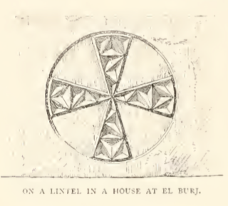
Al-Burj ( ar, البرج) was a Palestinian Arab village 14 km east of Ramle close to the highway to Ramallah, which was depopulated in 1948. Its name, "the tower", is believed to be derived from the crusader castle, Castle Arnold, built on the site. Victorian visitors in the 19th century recorded seeing crusader ruins close to the village. History A Byzantine lintel was found in the village in the 1870s, with "a Greek cross inscribed in a circle, and having its four arms ornamented with curious facet-work."Clermont-Ganneau, 1896, ARP II, p 98/ref> Just west of Al-Burj is ''Kŭlảt et Tantûrah'', "the castle of the peak." It is the remains of a tower, with 5 meter thick walls, and a door to the east. It is possible the Crusader castle called ''Tharenta'', under Muslim rule since 1187. While nearby Bayt Jiz often has been identified as the Crusader village of ''Gith'', some scholars (Schmitt, 1980; Fischer, Isaac and Roll, 1996) have suggested that ''Gith'' was actually ... [...More Info...] [...Related Items...] OR: [Wikipedia] [Google] [Baidu] |
Bir Salim
Bir Salim ( ar, بئر سالم) was a Palestinian Arab village in the Ramle Subdistrict of Mandatory Palestine. It was depopulated during the 1947–48 Civil War in Mandatory Palestine on May 9, 1948, by the Givati Brigade. It was located 4 km west of Ramla. History In the 1945 statistics, the village had a population of 410 Muslims, while the total land area was 3,401 dunams, according to an official land and population survey. Of this, 742 dunums of village land was used for citrus and bananas, 510 dunums were irrigated or used for plantations, 1,468 dunums were for cereals,Government of Palestine, Department of Statistics. ''Village Statistics, April, 1945.'' Quoted in Hadawi, 1970, p.114/ref> while 681 dunams were classified as non-cultivable areas.Government of Palestine, Department of Statistics. ''Village Statistics, April, 1945.'' Quoted in Hadawi, 1970, p 164/ref> 1948, aftermath Netzer Sereni was established on village land in 1948. See also *Schnell ... [...More Info...] [...Related Items...] OR: [Wikipedia] [Google] [Baidu] |
Bir Ma'in
Bir Ma'in was a Palestinian Arab village in the Ramle Subdistrict. It was depopulated during the 1948 Arab-Israeli War on July 15, 1948 during the second phase of Operation Danny by the First and Second Battalions of the Yiftach Brigade. It was located 14 km east of Ramla. The village was defended by the Jordanian Army. Foundation legend In 1873, Clermont-Ganneau noted down the foundation legend of Bir_Ma'in. He was told that the village mosque was consecrated to its founder, Neby Ma'in, son of Jacob. He was buried in a cave nearby. When he died, his five sisters hurried to Bir Ma'in from Jiser Benat Ya'kub ('Jacob Daughters' Bridge'). However, they all died at different places in the neighbourhood, and were buried where they died. Their tombs were still an object of veneration, ''Sitt Mena'' being one of them. History Crusader period Bir Ma'in was a fief of the Holy Sepulchre Church in the twelfth century.Conder and Kitchener, 1883, SWP III, p15/ref> In 1170, Bernhard, ... [...More Info...] [...Related Items...] OR: [Wikipedia] [Google] [Baidu] |
Bayt Susin
Bayt Susin ( ar, بَيْت سُوسِين) was a Palestinian Arab village in the Ramle Subdistrict of Mandatory Palestine, located southeast of Ramla. In 1945, it had 210 inhabitants. The village was depopulated during the 1948 war by the Israeli 7th Brigade. Geography Situated on a hilltop on the southern slopes of a mountainous area, Bayt Susin overlooked a wide area to its south and west. Below the village, two ''wadis'', streaming from the slopes, met. The village stood near a network of roads that led to many urban centers and was linked by a secondary road to the Jaffa-Jerusalem Highway.Khalidi, 1992, p.368. History Surrounding Bayt Susin were the ruins of a wall and cemeteries, cut stones, the foundations of houses, cisterns, and a basin. The Crusaders referred to the village as "Bezezin". Ottoman era While under the rule of the Ottoman Empire, in 1596, Bayt Susin was under the administration of the ''nahiya'' ("subdistrict") of Ramla, part of the Sanjak of Gaza, wit ... [...More Info...] [...Related Items...] OR: [Wikipedia] [Google] [Baidu] |
Bayt Shanna
Bayt Shanna was a Palestinian Arab village in the Ramle Subdistrict of Mandatory Palestine. It was depopulated during the 1948 Arab–Israeli War on July 15, 1948, during the second stage of Operation Dani. It was located 11.5 km southeast of Ramla. History Ceramics from the Byzantine era have been found here. Ottoman era Bayt Shanna was incorporated into the Ottoman Empire in 1517 with all of Palestine, and in 1596 it appeared in the tax registers under the name of ''Bayt Sanna'', as being in the ''nahiya'' ("subdistrict") of Ramla, which was under the administration of the '' liwa'' ("district") of Gaza. It had a population of 4 household;Hütteroth and Abdulfattah, 1977, p. 155 an estimated 22 persons, who were all Muslims. They paid a fixed tax-rate of 25 % on agricultural products, including wheat, barley, summer crops, vineyards, fruit trees, goats and beehives, in addition to occasional revenues; a total of 1,000 Akçe. All of the revenue went to a Waqf.Khalidi, 1 ... [...More Info...] [...Related Items...] OR: [Wikipedia] [Google] [Baidu] |
Bayt Nabala
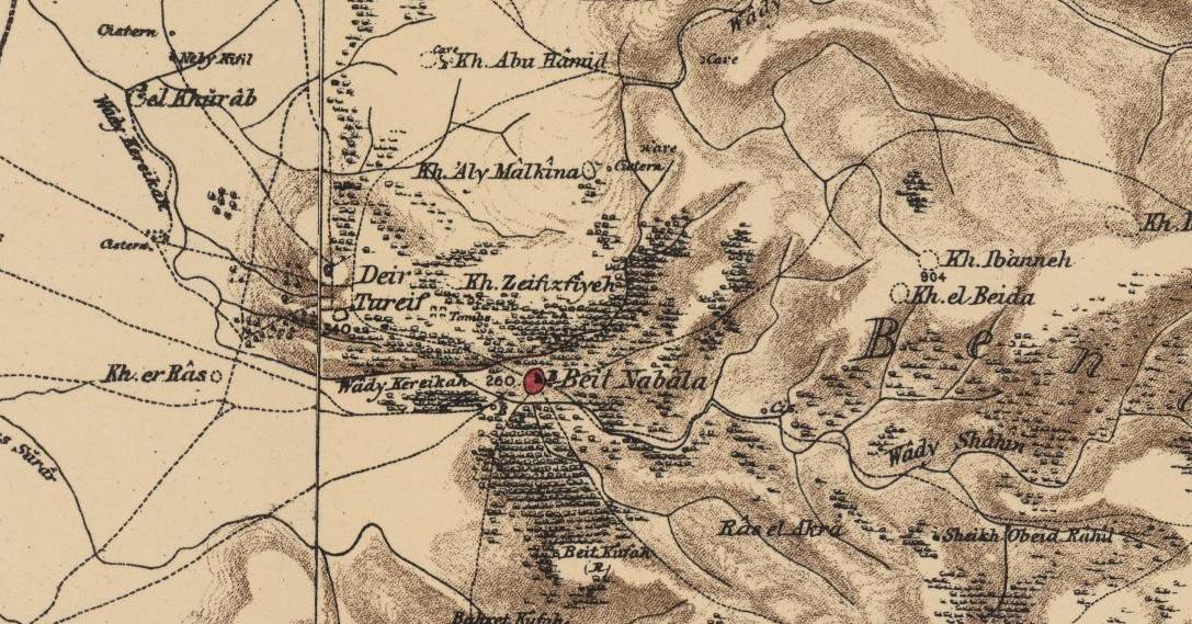
Bayt Nabala or Beit Nabala was a Palestinian Arab village in the Ramle Subdistrict in Palestine that was destroyed during the 1948 Arab–Israeli War. The village was in the territory allotted to the Arab state under the 1947 UN Partition Plan. Its population in 1945, before the war, was 2,310. It was occupied by Israeli forces on May 13, 1948 and was completely destroyed by them on September 13, 1948. Village refugees were scattered around Deir 'Ammar, Ramallah city, Bayt Tillow, Rantis, and Jalazone refugee camps north of Ramallah. Some of the clans that lived in Bayt Nabala include the AlHeet, Nakhleh, Safi, AL-Sharaqa, al-Khateeb, Saleh and Zaid families. Today the area is part of the Israeli town of Beit Nehemia. History In the 1596 tax record, Bayt Nabala was part of the Ottoman Empire, ''nahiya'' (subdistrict) of Ramla under the Liwa of Gaza, with a population of 54 Muslim households, an estimated 297 people. They paid a fixed tax-rate of 33,3 % on a number of crops ... [...More Info...] [...Related Items...] OR: [Wikipedia] [Google] [Baidu] |


