|
Rainy River, Ontario
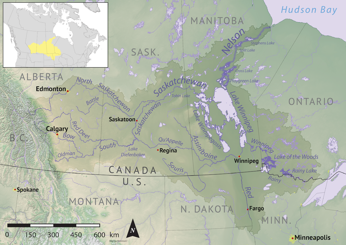
Rainy River is a town in north-western Ontario, Canada, southeast of Lake of the Woods. Rainy River is situated on the eponymous Rainy River (Minnesota–Ontario), Rainy River, which forms part of the Ontario-Minnesota segment of the Canada–United States border, Canada–US border. Across the river is the town of Baudette, Minnesota. The two towns are connected by the Baudette – Rainy River International Bridge. Rainy River is at the northwestern terminus of Ontario Highway 11, Highway 11. Rainy River was frequently thought to have been the northwestern terminus of Yonge Street, or Highway 11 running north from Toronto. Because of this incorrect conflation, Yonge Street was known as the "longest street in the world." and gained its fame in the Guinness World Records for many years. Highway 11 is marked through Rainy River as Atwood Avenue, although the town and the City of Toronto both maintain commemorative markers at each end. History From Rainy Lake, derived from the Frenc ... [...More Info...] [...Related Items...] OR: [Wikipedia] [Google] [Baidu] |
List Of Towns In Ontario
A town is a sub-type of List of municipalities in Ontario, municipalities in the Provinces and territories of Canada, Canadian province of Ontario. A town can have the municipal status of either a List of municipalities in Ontario#Single and lower-tier municipalities, single-tier or lower-tier municipality. Ontario has 89 towns that had a cumulative population of 1,813,458 and an average population of 22,316 in the Canada 2016 Census, 2016 Census. Ontario's largest and smallest towns are Oakville, Ontario, Oakville and Latchford, Ontario, Latchford with populations of 193,832 and 313 respectively. History Under the former ''Municipal Act, 1990'', a town was both an urban and a local municipality. Under this former legislation, a locality with a population of 2,000 or more could have been incorporated as a town by Ontario's Municipal Board upon review of an application from 75 or more residents of the locality. It also enabled the Municipal Board to ch ... [...More Info...] [...Related Items...] OR: [Wikipedia] [Google] [Baidu] |
Rainy River (Minnesota–Ontario)
The Rainy River (french: Rivière à la Pluie; oj, ojiji-ziibi) is a river, approximately long, forming part of the Canada–United States border separating Northwestern Ontario and northern Minnesota. History The river issues from the west side of Rainy Lake (French: ''lac à la Pluie''; Ojibwe: ''Gojiji-zaaga'igan'') and flows generally west-northwest, between International Falls, Minnesota, and Fort Frances, Ontario, and between Baudette, Minnesota, and Rainy River, Ontario. The Couchiching First Nation (the Ojibwe name spelled in transliterated form) is associated with this river, where it had traditional territory. The name of Koochiching County, Minnesota was derived from the Ojibwe term. Rainy Lake and the river were named by French colonists. These names were translated and adopted into English by British colonists. The town of Rainy River, Ontario was not developed until the late 19th century and not named until the early 20th century. The river enters the southe ... [...More Info...] [...Related Items...] OR: [Wikipedia] [Google] [Baidu] |
Ontario And Rainy River Railway
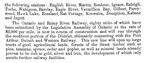
The Ontario and Rainy River Railway was a railway that existed briefly in the late 19th century. The company had been incorporated in 1886 to build a railway from Port Arthur, Ontario to the Rainy River. On the 4th of May 1899, the chief promoters of the Canadian Northern Railway Mackenzie and Mann had announced they had acquired the railway charter. Construction of the line began at Stanley, Ontario on 1 August 1898. The rail line ran from Stanley, Ontario to Rainy River, Ontario with eventual plans to connect to Port Arthur in the East, and to the Manitoba and Southeastern Railway, via a new Steel bridge at Rainy River. After the Baudette-Rainy River Rail Bridge was completed in 1901, the company was quickly absorbed by the Canadian Northern Railway, which built a roundhouse, a bunkhouse (to house train crews between shifts), a hotel and several other pieces of equipment at the town. It was taken over and absorbed by the Canadian National Railway in 1923, and still operates a ... [...More Info...] [...Related Items...] OR: [Wikipedia] [Google] [Baidu] |
Guinness World Records
''Guinness World Records'', known from its inception in 1955 until 1999 as ''The Guinness Book of Records'' and in previous United States editions as ''The Guinness Book of World Records'', is a reference book published annually, listing world records both of human achievements and the extremes of the natural world. The brainchild of Sir Hugh Beaver, the book was co-founded by twin brothers Norris and Ross McWhirter in Fleet Street, London, in August 1955. The first edition topped the best-seller list in the United Kingdom by Christmas 1955. The following year the book was launched internationally, and as of the 2022 edition, it is now in its 67th year of publication, published in 100 countries and 23 languages, and maintains over 53,000 records in its database. The international franchise has extended beyond print to include television series and museums. The popularity of the franchise has resulted in ''Guinness World Records'' becoming the primary international authority ... [...More Info...] [...Related Items...] OR: [Wikipedia] [Google] [Baidu] |
Toronto
Toronto ( ; or ) is the capital city of the Canadian province of Ontario. With a recorded population of 2,794,356 in 2021, it is the most populous city in Canada and the fourth most populous city in North America. The city is the anchor of the Golden Horseshoe, an urban agglomeration of 9,765,188 people (as of 2021) surrounding the western end of Lake Ontario, while the Greater Toronto Area proper had a 2021 population of 6,712,341. Toronto is an international centre of business, finance, arts, sports and culture, and is recognized as one of the most multicultural and cosmopolitan cities in the world. Indigenous peoples have travelled through and inhabited the Toronto area, located on a broad sloping plateau interspersed with rivers, deep ravines, and urban forest, for more than 10,000 years. After the broadly disputed Toronto Purchase, when the Mississauga surrendered the area to the British Crown, the British established the town of York in 1793 and later designat ... [...More Info...] [...Related Items...] OR: [Wikipedia] [Google] [Baidu] |
Yonge Street
Yonge Street (; pronounced "young") is a major arterial route in the Canadian province of Ontario connecting the shores of Lake Ontario in Toronto to Lake Simcoe, a gateway to the Upper Great Lakes. Once the southernmost leg of provincial Highway 11, linking the provincial capital with northern Ontario, Yonge Street has been referred to as "Main Street Ontario". Until 1999, the ''Guinness Book of World Records'' repeated the popular misconception that Yonge Street was long, making it the longest street in the world; this was due to a conflation of Yonge Street with the rest of Ontario's Highway 11. Yonge Street (including the Bradford-to-Barrie extension) is only long. Due to provincial downloading in the 1990s, no section of Yonge Street is marked as a provincial highway. The construction of Yonge Street is designated as an Event of National Historic Significance in Canada. Yonge Street was integral to the original planning and settlement of western Upper Canada in the ... [...More Info...] [...Related Items...] OR: [Wikipedia] [Google] [Baidu] |
Ontario Highway 11
King's Highway 11, commonly referred to as Highway 11, is a Ontario Provincial Highway Network, provincially maintained highway in the Provinces and territories of Canada, Canadian province of Ontario. At , it is the second longest highway in the province, following Ontario Highway 17, Highway 17. Highway11 begins at Ontario Highway 400, Highway 400 in Barrie, and arches through northern Ontario to the Ontario–Minnesota border at Rainy River, Ontario, Rainy River via Thunder Bay; the road continues as Minnesota State Highway 72 across the Baudette–Rainy River International Bridge. North and west of North Bay, Ontario, North Bay (as well as for a short distance through Orillia), Highway11 forms part of the Trans-Canada Highway. The highway is also part of MOM's Way between Thunder Bay and Rainy River. The original section of Highway11 along Yonge Street was colloquially known as "Main Street Ontario", and was one of the first roads in what would later become Onta ... [...More Info...] [...Related Items...] OR: [Wikipedia] [Google] [Baidu] |
Baudette – Rainy River International Bridge
Baudette is a city in, and the county seat of, Lake of the Woods County, Minnesota, United States. As of the 2010 census, its population was 1,106, and in 2018 the population was estimated at 1,003. Baudette is known as the Walleye Capital of the World. History Baudette was incorporated in 1907. It was started by European Americans as a steamboat landing and lumber town with a sawmill, after the railroad was constructed through this area in 1901. It was named for Joseph Beaudette, a trapper of French-Canadian descent who had been in the area since the early 1880s. The post office at Baudette began in 1900, first called "Port Hyland", after postmaster Daniel Hyland. The name was changed to "Baudette" in 1901. Baudette had a station of the Minnesota and Manitoba Railroad, now absorbed by the Canadian National Railway. Baudette was largely destroyed in the Baudette Fire of 1910, but was quickly rebuilt. Many of its people were saved by a train with boxcars sent across the river f ... [...More Info...] [...Related Items...] OR: [Wikipedia] [Google] [Baidu] |


.jpg)


