|
RINEX
In the field of geodesy, Receiver Independent Exchange Format (RINEX) is a data exchange, data interchange format for raw global navigation satellite system, satellite navigation system data. This allows the user to post-process the received data to produce a more accurate result — usually with other data unknown to the original receiver, such as better models of the atmospheric conditions at time of measurement. The final output of a navigation receiver is usually its position, speed or other related physical quantities. However, the calculation of these quantities are based on a series of measurements from one or more satellite constellations. Although receivers calculate positions in real time, in many cases it is interesting to store intermediate measures for later use. RINEX is the standard format that allows the management and disposal of the measures generated by a receiver, as well as their off-line processing by a multitude of applications, whatever the manufacturer o ... [...More Info...] [...Related Items...] OR: [Wikipedia] [Google] [Baidu] |
Geodesy
Geodesy ( ) is the Earth science of accurately measuring and understanding Earth's figure (geometric shape and size), orientation in space, and gravity. The field also incorporates studies of how these properties change over time and equivalent measurements for other planets (known as '' planetary geodesy''). Geodynamical phenomena, including crustal motion, tides and polar motion, can be studied by designing global and national control networks, applying space geodesy and terrestrial geodetic techniques and relying on datums and coordinate systems. The job title is geodesist or geodetic surveyor. History Definition The word geodesy comes from the Ancient Greek word ''geodaisia'' (literally, "division of Earth"). It is primarily concerned with positioning within the temporally varying gravitational field. Geodesy in the German-speaking world is divided into "higher geodesy" ( or ), which is concerned with measuring Earth on the global scale, and "practical geodes ... [...More Info...] [...Related Items...] OR: [Wikipedia] [Google] [Baidu] |
Satellite Based Augmentation System
Augmentation of a global navigation satellite system (GNSS) is a method of improving the navigation system's attributes, such as precision, reliability, and availability, through the integration of external information into the calculation process. There are many such systems in place, and they are generally named or described based on how the GNSS sensor receives the external information. Some systems transmit additional information about sources of error (such as clock drift, ephemeris, or ionospheric delay), others provide direct measurements of how much the signal was off in the past, while a third group provides additional vehicle information to be integrated in the calculation process. Satellite-based augmentation system Satellite-based augmentation systems (SBAS) support wide-area or regional augmentation through the use of additional satellite-broadcast messages. Using measurements from the ground stations, correction messages are created and sent to one or more sate ... [...More Info...] [...Related Items...] OR: [Wikipedia] [Google] [Baidu] |
Navigational Equipment
Navigation is a field of study that focuses on the process of monitoring and controlling the motion, movement of a craft or vehicle from one place to another.Bowditch, 2003:799. The field of navigation includes four general categories: land navigation, marine navigation, aeronautic navigation, and space navigation. It is also the term of art used for the specialized knowledge used by navigators to perform navigation tasks. All navigational techniques involve locating the navigator's Position (geometry), position compared to known locations or patterns. Navigation, in a broader sense, can refer to any skill or study that involves the determination of position and Relative direction, direction. In this sense, navigation includes orienteering and pedestrian navigation. History In the European medieval period, navigation was considered part of the set of ''Artes mechanicae, seven mechanical arts'', none of which were used for long voyages across open ocean. Polynesian navigation ... [...More Info...] [...Related Items...] OR: [Wikipedia] [Google] [Baidu] |
Navigation
Navigation is a field of study that focuses on the process of monitoring and controlling the movement of a craft or vehicle from one place to another.Bowditch, 2003:799. The field of navigation includes four general categories: land navigation, marine navigation, aeronautic navigation, and space navigation. It is also the term of art used for the specialized knowledge used by navigators to perform navigation tasks. All navigational techniques involve locating the navigator's position compared to known locations or patterns. Navigation, in a broader sense, can refer to any skill or study that involves the determination of position and direction. In this sense, navigation includes orienteering and pedestrian navigation. History In the European medieval period, navigation was considered part of the set of '' seven mechanical arts'', none of which were used for long voyages across open ocean. Polynesian navigation is probably the earliest form of open-ocean navigation; it was ... [...More Info...] [...Related Items...] OR: [Wikipedia] [Google] [Baidu] |
Geographical Technology
Geography (from Greek: , ''geographia''. Combination of Greek words ‘Geo’ (The Earth) and ‘Graphien’ (to describe), literally "earth description") is a field of science devoted to the study of the lands, features, inhabitants, and phenomena of Earth. The first recorded use of the word γεωγραφία was as a title of a book by Greek scholar Eratosthenes (276–194 BC). Geography is an all-encompassing discipline that seeks an understanding of Earth and its human and natural complexities—not merely where objects are, but also how they have changed and come to be. While geography is specific to Earth, many concepts can be applied more broadly to other celestial bodies in the field of planetary science. One such concept, the first law of geography, proposed by Waldo Tobler, is "everything is related to everything else, but near things are more related than distant things." Geography has been called "the world discipline" and "the bridge between the human and ... [...More Info...] [...Related Items...] OR: [Wikipedia] [Google] [Baidu] |
Geodesy
Geodesy ( ) is the Earth science of accurately measuring and understanding Earth's figure (geometric shape and size), orientation in space, and gravity. The field also incorporates studies of how these properties change over time and equivalent measurements for other planets (known as '' planetary geodesy''). Geodynamical phenomena, including crustal motion, tides and polar motion, can be studied by designing global and national control networks, applying space geodesy and terrestrial geodetic techniques and relying on datums and coordinate systems. The job title is geodesist or geodetic surveyor. History Definition The word geodesy comes from the Ancient Greek word ''geodaisia'' (literally, "division of Earth"). It is primarily concerned with positioning within the temporally varying gravitational field. Geodesy in the German-speaking world is divided into "higher geodesy" ( or ), which is concerned with measuring Earth on the global scale, and "practical geodes ... [...More Info...] [...Related Items...] OR: [Wikipedia] [Google] [Baidu] |
Satellite Navigation
A satellite navigation or satnav system is a system that uses satellites to provide autonomous geo-spatial positioning. It allows satellite navigation devices to determine their location (longitude, latitude, and altitude/elevation) to high precision (within a few centimetres to metres) using time signals transmitted along a line of sight by radio from satellites. The system can be used for providing position, navigation or for tracking the position of something fitted with a receiver (satellite tracking). The signals also allow the electronic receiver to calculate the current local time to a high precision, which allows time synchronisation. These uses are collectively known as Positioning, Navigation and Timing (PNT). One set of critical vulnerabilities in satellite communications are the signals that govern positioning, navigation and timing (PNT). Failure to properly secure these transmissions could not only disrupt satellite networks but wreak havoc on a host of dependent s ... [...More Info...] [...Related Items...] OR: [Wikipedia] [Google] [Baidu] |
Geographical Survey Institute
The , or GSI, is the national institution responsible for surveying and mapping the national land of Japan. The former name of the organization from 1949 until March 2010 was Geographical Survey Institute; despite the rename, it retains the same initials. It is an extraordinary organ of the Ministry of Land, Infrastructure, Transport and Tourism. Its main offices are situated in Tsukuba City of Ibaraki Prefecture. It also runs a museum, situated in Tsukuba, the Science Museum of Map and Survey. Earthquake Precursor Prediction Research Stationary MT monitoring systems have been installed in Japan since April 1996, providing a continuous recording of MT signals at the Mizusawa Geodetic Observatory and the Esashi Station of the GSI. These stations measure fluctuations in the earth's electromagnetic field that correspond with seismic activity. The raw geophysical time-series data from these monitoring stations is freely available to the scientific community, enabling further study ... [...More Info...] [...Related Items...] OR: [Wikipedia] [Google] [Baidu] |
GPS Modernization
GPS Block III (previously Block IIIA) consists of the first ten GPS III satellites, which will be used to keep the Navstar Global Positioning System operational. Lockheed Martin designed, developed and manufactured the GPS III Non-Flight Satellite Testbed (GNST) and all ten Block III satellites. The first satellite in the series was launched in December 2018. The tenth and final GPS Block III launch is projected in 2023. History The United States' Global Positioning System (GPS) reached Full Operational Capability on 17 July 1995, completing its original design goals. Advances in technology and new demands on the existing system led to the effort to modernize the GPS system. In 2000, the U.S. Congress authorized the effort, referred to as GPS III. The project involves new ground stations and new satellites, with additional navigation signals for both civilian and military users, and aims to improve the accuracy and availability for all users. Raytheon was awarded the Nex ... [...More Info...] [...Related Items...] OR: [Wikipedia] [Google] [Baidu] |
QZSS
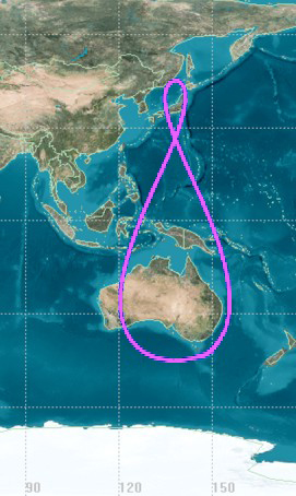
The Quasi-Zenith Satellite System (QZSS), also known as , is a four-satellite regional time transfer system and a satellite-based augmentation system developed by the Japanese government to enhance the United States-operated Global Positioning System (GPS) in the Asia-Oceania regions, with a focus on Japan. The goal of QZSS is to provide highly precise and stable positioning services in the Asia-Oceania region, compatible with GPS. Four-satellite QZSS services were available on a trial basis as of 12 January 2018, and officially started on 1 November 2018. A satellite navigation system independent of GPS is planned for 2023 with 7 satellites. History In 2002, the Japanese government authorized the development of QZSS, as a three-satellite regional time transfer system and a satellite-based augmentation system for the United States operated Global Positioning System (GPS) to be receivable within Japan. A contract was awarded to Advanced Space Business Corporation (ASBC), th ... [...More Info...] [...Related Items...] OR: [Wikipedia] [Google] [Baidu] |
Wide Area Augmentation System
The Wide Area Augmentation System (WAAS) is an air navigation aid developed by the Federal Aviation Administration to augment the Global Positioning System (GPS), with the goal of improving its accuracy, integrity, and availability. Essentially, WAAS is intended to enable aircraft to rely on GPS for all phases of flight, including precision approaches to any airport within its coverage area.Federal Aviation Administration (FAAFAQ for WAAS/ref> It may be further enhanced with the Local Area Augmentation System (LAAS) also known by the preferred ICAO term Ground-Based Augmentation System (GBAS) in critical areas. WAAS uses a network of ground-based reference stations, in North America and Hawaii, to measure small variations in the GPS satellites' signals in the western hemisphere. Measurements from the reference stations are routed to master stations, which queue the received Deviation Correction (DC) and send the correction messages to geostationary WAAS satellites in a timely ... [...More Info...] [...Related Items...] OR: [Wikipedia] [Google] [Baidu] |
Data Exchange
Data exchange is the process of taking data structured under a ''source'' schema and transforming it into a ''target'' schema, so that the target data is an accurate representation of the source data.A. Doan, A. Halevy, and Z. Ives.Principles of data integration, Morgan Kaufmann,s 2012 pp. 276 Data exchange allows data to be shared between different computer programs. It is similar to the related concept of data integration except that data is actually restructured (with possible loss of content) in data exchange. There may be no way to transform an instance given all of the constraints. Conversely, there may be numerous ways to transform the instance (possibly infinitely many), in which case a "best" choice of solutions has to be identified and justified. Single-domain data exchange In some domains, a few dozen different source and target schema (proprietary data formats) may exist. An "exchange" or "interchange format" is often developed for a single domain, and then necessar ... [...More Info...] [...Related Items...] OR: [Wikipedia] [Google] [Baidu] |


