|
Regions Of Somaliland
The regions of Somaliland ( so, Gobolada Somaliland; ar, محافظات صوماليلاند) is divided into six administrative regions, Awdal, Sahil, Maroodi-Jeeh, Togdheer, Sanaag and Sool. These are in turn subdivided into twenty-two districts. Regions of Somaliland are the primary geographical divisions through which Somaliland is administered. A distinction is made between districts of grades A, B, C and D, with the classification being based on population, area, economy and production. Regions History British territory and independence era The local administration of British Somaliland (1884-June 26, 1960) was stipulated primarily by the Local Government Ordinance of 1953. The ordinance established councils in six districts that had divided Somaliland since 1944. The ordinance continued to be used after independence as the State of Somaliland (June 26-July 1, 1960). At the time of the integration with Italian Somaliland on July 1, 1960, there were the follow ... [...More Info...] [...Related Items...] OR: [Wikipedia] [Google] [Baidu] |
Somali Language
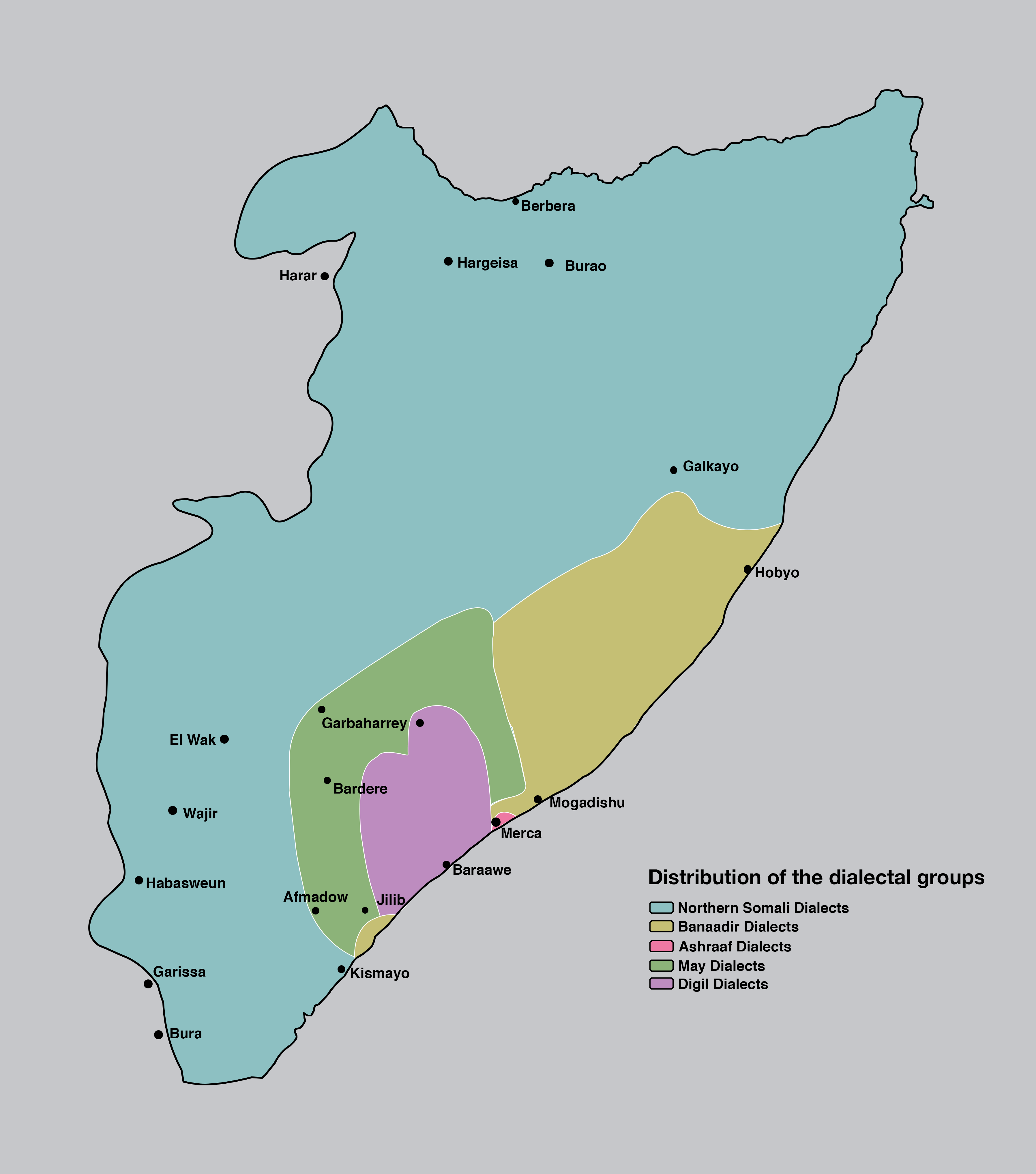
Somali (Latin script: ; Wadaad writing, Wadaad: ; Osmanya: 𐒖𐒍 𐒈𐒝𐒑𐒛𐒐𐒘 ) is an Afroasiatic languages, Afroasiatic language belonging to the Cushitic languages, Cushitic branch. It is spoken as a mother tongue by Somalis in Greater Somalia and the Somali diaspora. Somali is an official language in Somalia and Ethiopia, and a national language in Djibouti as well as in northeastern Kenya. The Somali language is written officially with the Somali Latin alphabet, Latin alphabet although the Arabic alphabet and several Somali scripts like Osmanya script, Osmanya, Kaddare script, Kaddare and the Gadabuursi Somali Script, Borama script are informally used.Lewis, I.M. (1958)The Gadabuursi Somali Script ''Bulletin of the School of Oriental and African Studies'', University of London, Vol. 21, pp. 134–156. Classification Somali is classified within the Cushitic branch of the Afroasiatic family, specifically, Lowland East Cushitic languages, Lowland East Cushitic in ... [...More Info...] [...Related Items...] OR: [Wikipedia] [Google] [Baidu] |
Baki District
Baki District ( so, Degmada Baki) is a Administrative divisions of Somaliland, district in the Awdal region of western Somaliland. Demographics Baki is inhabited by the Reer Nuur branch of the Makahiil and Reer Mohamed branch of the Mahad 'Ase subclans of the Gadabuursi Dir (clan), Dir clan. Mayor *Idiris Faarax Rooble 2002 *Saleebaan Maxamuud Aadan 2016 Mining The Simodi Mountains, located 48 km east of Baki village, have long been used as a mine. In the past, coltan and other materials were mined, and nowadays beryllium is mined and is called the Simodi Beryllium Mining Site. Mining rights are complex. The Somaliland government has granted mining rights to China's African Resources Corporation (ARC.) However, local clans have complained that profits are not being returned to the local community. Somaliland government effectively controls Baki district, so the Federal Republic of Somalia has no real authority over it at all. However, there had been discussions between the Min ... [...More Info...] [...Related Items...] OR: [Wikipedia] [Google] [Baidu] |
Burao
Burao, also spelt Bur'o or Bur'ao (; so, Burco, , ar, برعو) is the capital of the Togdheer region and the second largest city in Somaliland. Burao was also the third largest city of Somalia. Burao was the site of the declaration of an independent Somaliland on 18 May 1991. History 19th century The city originated as a well named Ceel-Gooni in the late 19th century used by nomads from the surrounding area. The town subsequently grew around the well. The settlement was later on burned to the ground by British forces in 1900, with the modern settlement being re-established in 1910. For much of the 19th century, Burao served as the capital of the Habr Yunis Sultanate. Sultan Nur Ahmed Aman, Sutan Awad Deria and Sultan Madar Hersi ruled from Burao at different periods of time. After leaving the Berbera coastlands and ascending the escarpments of the great inland plateau, the convoy followed the valley of the Tug Dayr as far as Burao, capital of a powerful but friendly Habr ... [...More Info...] [...Related Items...] OR: [Wikipedia] [Google] [Baidu] |
Togdheer In Somaliland
Togdheer ( so, Togdheer, ar, تُوْجْدَيْر, Tūjdayr) is an administrative region ('' gobol'') in central Somaliland. Togdheer is bordered by Maroodi Jeex to the west, Saaxil to the north, Sanaag to the northeast, Sool to the east and Ethiopia to the south. Its capital is Burao. Overview Togdheer is bordered by Maroodi Jeex from the west, Sahil to the north, Ethiopia to the south, and Sanaag & Sool to the east. With its capital at Burao (Burco), the region's name is derived from the Togdheer River, which means "Long River" in Somali. The region has an approximate population of 350,000 people. Under British Somaliland, the Togdheer region was formerly the Burao district which was one of three districts that comprised the Burao region. The other two regions were Las Anod and Erigavo districts. Sanaag was carved out of Togdheer region and was established as a separate region on June 23, 1973, comprising the three districts of Erigavo, Las Qorey and Garadag. As with mu ... [...More Info...] [...Related Items...] OR: [Wikipedia] [Google] [Baidu] |
Hargeisa District
Hargeisa District ( so, Degmada Hargeysa) is a district in the Maroodi Jeex region in Somaliland. Its capital lies at Hargeisa. Other settlements in the district include Daarbuduq Daar buduq ( so, Dacarbudhuq) is a town in the Marodi Jeh province of Somaliland. Situated in the Hargeisa District, it is located northeast by road from Hargeisa and southwest of Berbera. The town is inhabited by people from the Adam Issa sub .... References External links Administrative map of Hargeisa District Districts of Somaliland Maroodi Jeex {{Somaliland-geo-stub ... [...More Info...] [...Related Items...] OR: [Wikipedia] [Google] [Baidu] |
Gabiley District
Gabiley District ( so, Degmada Gabiley) is a Administrative divisions of Somaliland, district in the Maroodi Jeex province of Somaliland, with its capital in Gabiley. Demographics The broader Gabiley District has a total population of 320,430. It has been considered to be the fastest growing population district in Somaliland due to its fertile land. http://www.fsnau.org/ipc/population-table. Retrieved on 2011-12-15. The Gabiley District is inhabited by people from the Somali ethnic group. This district is wholly dominated by the Jibril Abokor and Abdalla Abokor sub divisions of the Sacad Muuse, Sa'ad Musa subclan of the Habar Awal Isaaq. Townships The majority of the people in the district have been settled there for the last 300 years. There are more major and minor towns in Gabiley district than anywhere ...[...More Info...] [...Related Items...] OR: [Wikipedia] [Google] [Baidu] |
Hargeisa
Hargeisa (; so, Hargeysa, ar, هرجيسا) is the capital and largest city of the Republic of Somaliland. It is located in the Maroodi Jeex region of the Horn of Africa. It succeeded Burco as the capital of the British Somaliland Protectorate in 1941. Hargeisa is the largest city in Somaliland, and also served as the capital of the Isaaq Sultanate during the mid-to-late 19th century. Hargeisa was founded as a watering and trading stop between the coast and the interior by the Isaaq Sultanate. Initially it served as a watering Well for the vast livestock of the Eidagale clans that inhabited in that specific region and later were joined by the current clans of Hargeisa. In 1960, the Somaliland Protectorate gained independence from the United Kingdom and as scheduled united days later with the Trust Territory of Somaliland (former Italian Somaliland) to form the Somali Republic on July 1. Encyclopædia Britannica, ''The New Encyclopædia Britannica'', (Encyclopædia Britanni ... [...More Info...] [...Related Items...] OR: [Wikipedia] [Google] [Baidu] |
Berbera District
Berbera District ( so, Degmada Barbara) is a district of the Sahil province in Somaliland. Its capital lies at Berbera. Demographics It is inhabited by people from the CIISE MUUSE, Garhajis and Habr Je'lo sub-clans of the Isaaq Somalis The Somalis ( so, Soomaalida 𐒈𐒝𐒑𐒛𐒐𐒘𐒆𐒖, ar, صوماليون) are an ethnic group native to the Horn of Africa who share a common ancestry, culture and history. The Lowland East Cushitic Somali language is the shared .... References External links Districts of SomaliaAdministrative map of Berbera District Districts of Somaliland Populated places in Sahil, Somaliland {{Somaliland-geo-stub ... [...More Info...] [...Related Items...] OR: [Wikipedia] [Google] [Baidu] |
Sheikh District
Sheikh District ( so, Degmada Sheekh) is a district in the Sahil region of Somaliland. Its capital lies at Sheikh. The district was part of Togdheer region until 1998, when the Sheikh District was incorporated into the Sahil region. Overview Sheikh District is inhabited by the Issa Musse sub-clan of the Habr Awal as well as the Musa Abdallah branch of the Habr Yunis sub-clan of the Garhajis The Garhajis ( so, Garxajis, ar, غرحجس , Full Name: ''Al-Qādhī Ismā'īl ibn ash-Shaykh Isḥāq ibn Aḥmad bin Muḥammad bin'' ''al-Ḥusayn al-Hāshimīy'') historically known as the Habar Gerhajis () is a major clan of the wider Isa .... As with many other areas in the Somaliland interior, Sheikh is noted for its numerous historical structures and mountainous scenery. References External links Districts of Somalia [...More Info...] [...Related Items...] OR: [Wikipedia] [Google] [Baidu] |
Berbera
Berbera (; so, Barbara, ar, بربرة) is the capital of the Sahil region of Somaliland and is the main sea port of the country. Berbera is a coastal city and was the former capital of the British Somaliland protectorate before Hargeisa. It also served as a major port of the Ifat, Adal and Isaaq sultanates from the 13th to 19th centuries. In antiquity, Berbera was part of a chain of commercial port cities along the Somali seaboard. During the early modern period, Berbera was the most important place of trade in the Somali Peninsula. It later served as the capital of the British Somaliland protectorate from 1884 to 1941, when it was replaced by Hargeisa. In 1960, the British Somaliland protectorate gained independence as the State of Somaliland and united five days later with the Trust Territory of Somalia (the former Italian Somalia) to form the Somali Republic.Encyclopædia Britannica, ''The New Encyclopædia Britannica'', (Encyclopædia Britannica: 2002), p.835 Located s ... [...More Info...] [...Related Items...] OR: [Wikipedia] [Google] [Baidu] |
Sahil In Somaliland
Sahil may refer to: * Sahil, Azerbaijan, a municipality in Baku, Azerbaijan * Sahil (Baku Metro), a metro station of the Baku Metro * Sahil, Saudi Arabia, a city in the governorate of Bareq, Saudi Arabia * Sahil, Somaliland Sahil ( so, Saaxil, ar, ساحل) is an administrative region ('' gobol'') in northern Somaliland with the port city of Berbera as its capital. It was separated from Woqooyi Galbeed and became a province in 1991. In 1998, the Sheikh District of ..., a region of Somaliland * Sahil (name), an Indian name (including a list of people with the name) * ''Sahil'' (film), a 1959 Indian film {{disambiguation, geo ... [...More Info...] [...Related Items...] OR: [Wikipedia] [Google] [Baidu] |


