|
Raytheon Intelligence, Information And Services
Raytheon Intelligence, Information, and Services (RIIS or IIS) is a business unit of Raytheon Company headquartered in Dulles, Virginia. IIS specializes in intelligence, surveillance, and reconnaissance, advanced cybersecurity services; weather and environmental services, and information-based services for homeland security. The company also provides training, logistics, engineering, product support, and operational support services and solutions for mission support, homeland security, space, civil aviation, counter-proliferation, and counter-terrorism markets. History Originally founded as LTV Electro Systems in the mid-1960s, the company changed its name to E-Systems in the early 1970s. In 1995, Raytheon Company acquired E-Systems, Inc., a Texas-based company that designed, developed, produced, and serviced high-technology systems including surveillance, verification, and aircraft ground-land navigation equipment. The company also developed electronics programs and systems fo ... [...More Info...] [...Related Items...] OR: [Wikipedia] [Google] [Baidu] |
Dulles, Virginia
Dulles ( ) is an unincorporated area in Loudoun County, Virginia, United States, and is part of the Washington metropolitan area. The headquarters of Northrop Grumman Innovation Systems and ODIN Technologies, as well as the former headquarters of MCI Inc. and AOL are located in Dulles. The National Weather Service Baltimore/Washington forecast office and the National Weather Service's Sterling Field Support Center are also both in Dulles. Geography Dulles covers roughly the southwestern third of Sterling, Virginia (another unincorporated community). The usage of Dulles as a community name began in the mid-1980s when Loudoun County economic development officer Pam Treadwell successfully lobbied the United States Postal Service to allow Sterling businesses and residents to use Dulles as an alternative address. The USPS defines Dulles as an "acceptable" city name for the 20166 ZIP code, whose "recommended" city name is Sterling. Dulles is also the city name for ZIP code 20189. ... [...More Info...] [...Related Items...] OR: [Wikipedia] [Google] [Baidu] |
Raytheon
Raytheon is a business unit of RTX Corporation and is a major U.S. defense contractor and industrial corporation with manufacturing concentrations in weapons and military and commercial electronics. Founded in 1922, it merged in 2020 with United Technologies Corporation to form Raytheon Technologies, which changed its name to RTX Corporation in July 2023. Raytheon was established in 1922, reincorporated in 1928, and adopted the Raytheon Company name in 1959. More than 90% of Raytheon's revenues were obtained from military contracts and, as of 2012, it was the fifth-largest military contractor in the world. , it was the third-largest defense contractor in the United States by defense revenue. It was the world's largest producer of guided missiles, and was involved in corporate and special-mission aircraft until early 2007. In 2018, the company had around 67,000 employees worldwide and annual revenues of about US$25.35 billion. Over the years, Raytheon shifted its headquarters ... [...More Info...] [...Related Items...] OR: [Wikipedia] [Google] [Baidu] |
Linthicum, Maryland
Linthicum is a census-designated place (CDP) and unincorporated community in Anne Arundel County, Maryland, United States. The population was 10,324 at the 2010 census. It is located directly north of Baltimore–Washington International Thurgood Marshall Airport (BWI). Designated as "Linthicum Heights" and zip code 21090 by the U.S. Postal Service, Linthicum has been traditionally divided into two distinct communities each with its own community association and identity. These two communities, split by the Baltimore Beltway in 1957, are Linthicum and North Linthicum (or, alternatively, Linthicum-Shipley and North Linthicum.) Both communities developed as a result of their locations adjacent to the Baltimore and Annapolis Short Line railroad which brought commuters to the original truck farming community. As a developed community, Linthicum began with the 1908 founding of the "Linthicum Heights Company", though a "Linthicum" or "Linthicum's" station on the 1887 Annapolis a ... [...More Info...] [...Related Items...] OR: [Wikipedia] [Google] [Baidu] |
Indianapolis, Indiana
Indianapolis ( ), colloquially known as Indy, is the List of capitals in the United States, capital and List of municipalities in Indiana, most populous city of the U.S. state of Indiana and the county seat of Marion County, Indiana, Marion County. Indianapolis is situated in the state's central till plain region along the west fork of the White River (Indiana), White River. The city's official slogan, "Crossroads of America", reflects its historic importance as a transportation hub and its relative proximity to other major North American markets. At the 2020 United States census, 2020 census, the Indianapolis (balance), balance population was 887,642. Indianapolis is the List of United States cities by population, 16th-most populous city in the U.S., the third-most populous city in the Midwestern United States, Midwest after Chicago and Columbus, Ohio, and the fourth-most populous state capital in the nation after Phoenix, Arizona, Phoenix, Austin, Texas, Austin, and Columbu ... [...More Info...] [...Related Items...] OR: [Wikipedia] [Google] [Baidu] |
Orlando, Florida
Orlando ( ) is a city in and the county seat of Orange County, Florida, United States. The city proper had a population of 307,573 at the 2020 census, making it the fourth-most populous city in Florida behind Jacksonville, Florida, Jacksonville, Miami, and Tampa, Florida, Tampa and the state's most populous inland city. Part of Central Florida, it is the center of the Greater Orlando, Orlando metropolitan area, which had a population of 2.67 million in 2020. It is the sixth-largest metropolitan area in the Southern United States and the third-largest metropolitan area in Florida behind Miami metropolitan area, Miami and Tampa Bay area, Tampa Bay. Orlando is one of the most-visited cities in the world primarily due to tourism, major events, and convention traffic. It is the fourth-most visited city in the U.S. after New York City, Miami, and Los Angeles, with over 3.5 million visitors as of 2023. Orlando International Airport is the List of the busiest airports in the United Stat ... [...More Info...] [...Related Items...] OR: [Wikipedia] [Google] [Baidu] |
Aurora, Colorado
Aurora (, ) is a List of municipalities in Colorado#Home rule municipality, home rule city located in Arapahoe County, Colorado, Arapahoe, Adams County, Colorado, Adams, and Douglas County, Colorado, Douglas List of counties in Colorado, counties, Colorado, United States. The city's population was 386,261 at the 2020 United States census with 336,035 residing in Arapahoe County, 47,720 residing in Adams County, and 2,506 residing in Douglas County. Aurora is the List of municipalities in Colorado, third-most-populous city in the State of Colorado and the List of United States cities by population, 51st-most-populous city in the United States. Aurora is a principal city of the Denver–Aurora–Centennial, CO Metropolitan Statistical Area and the Denver-Aurora, CO Combined Statistical Area, and a major city of the Front Range Urban Corridor. History Before European settlement, the land that now makes up Aurora was the territory of the Arapaho, Cheyenne, Núu-agha-tʉvʉ-pʉ̱ (U ... [...More Info...] [...Related Items...] OR: [Wikipedia] [Google] [Baidu] |
Richardson, Texas
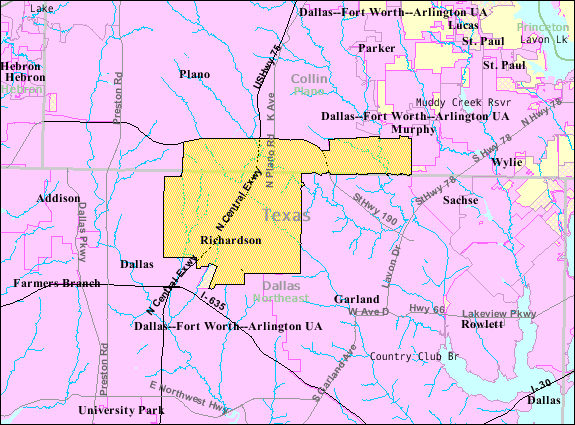
Richardson is a city in Dallas and Collin counties in the U.S. state of Texas. As of the 2020 United States census, the city had a total population of 119,469. Richardson is an inner suburb of the city of Dallas. It is home to the University of Texas at Dallas and the Telecom Corridor, with a high concentration of telecommunications companies. More than 5,000 businesses have operations within Richardson's , including many of the world's largest telecommunications and networking companies, such as AT&T, Verizon, Cisco Systems, Samsung, ZTE, MetroPCS, Texas Instruments, Qorvo, and Fujitsu. Richardson's largest employment base is provided by the insurance industry, with Blue Cross and Blue Shield of Texas's headquarters, a regional hub for the insurance company GEICO, regional offices for United Healthcare, and one of State Farm Insurance's three national regional hubs located in the community. History Emigrants from Kentucky and Tennessee settled near present-day Richa ... [...More Info...] [...Related Items...] OR: [Wikipedia] [Google] [Baidu] |
Global Positioning System
The Global Positioning System (GPS) is a satellite-based hyperbolic navigation system owned by the United States Space Force and operated by Mission Delta 31. It is one of the global navigation satellite systems (GNSS) that provide geolocation and time information to a GPS receiver anywhere on or near the Earth where there is an unobstructed line of sight to four or more GPS satellites. It does not require the user to transmit any data, and operates independently of any telephone or Internet reception, though these technologies can enhance the usefulness of the GPS positioning information. It provides critical positioning capabilities to military, civil, and commercial users around the world. Although the United States government created, controls, and maintains the GPS system, it is freely accessible to anyone with a GPS receiver. Overview The GPS project was started by the U.S. Department of Defense in 1973. The first prototype spacecraft was launched in 1978 an ... [...More Info...] [...Related Items...] OR: [Wikipedia] [Google] [Baidu] |
Geospatial Intelligence
In the United States, geospatial intelligence (GEOINT) is intelligence about the human activity on Earth derived from the exploitation and analysis of imagery, signals, or signatures with geospatial information. GEOINT describes, assesses, and visually depicts physical features and geographically referenced activities on the Earth. GEOINT, as defined in US Code, consists of imagery, imagery intelligence (IMINT) and geospatial information. GEOINT knowledge and related tradecraft is no longer confined to the U.S. government, or even the world's leading military powers. Additionally, countries such as India are holding GEOINT-specific conferences. While other countries may define geospatial intelligence somewhat differently than does the U.S., the use of GEOINT data and services is the same. Geospatial Intelligence can also be referred to as "Location Intelligence". Although GEOINT is inclusive, HYDROSPATIAL is preferably used to refer and to focus on the aquatic and coastal zones ... [...More Info...] [...Related Items...] OR: [Wikipedia] [Google] [Baidu] |
Signals Intelligence
Signals intelligence (SIGINT) is the act and field of intelligence-gathering by interception of ''signals'', whether communications between people (communications intelligence—abbreviated to COMINT) or from electronic signals not directly used in communication (electronic intelligence—abbreviated to ELINT). As classified and sensitive information is usually encrypted, signals intelligence may necessarily involve cryptanalysis (to decipher the messages). Traffic analysis—the study of who is signaling to whom and in what quantity—is also used to integrate information, and it may complement cryptanalysis. History Origins Electronic interceptions appeared as early as 1900, during the Boer War of 1899–1902. The British Royal Navy had installed wireless sets produced by Marconi on board their ships in the late 1890s, and the British Army used some limited wireless signalling. The Boers captured some wireless sets and used them to make vital transmissions. Since the ... [...More Info...] [...Related Items...] OR: [Wikipedia] [Google] [Baidu] |
Advanced Persistent Threat
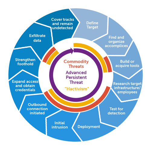
An advanced persistent threat (APT) is a stealthy threat actor, typically a State (polity), state or state-sponsored group, which gains unauthorized access to a computer network and remains undetected for an extended period. In recent times, the term may also refer to non-state-sponsored groups conducting large-scale targeted intrusions for specific goals. Such threat actors' motivations are typically political or economic. Every major business sector has recorded instances of cyberattacks by advanced actors with specific goals, whether to steal, spy, or disrupt. These targeted sectors include government, Arms industry, defense, financial services, Practice of law, legal services, Manufacturing, industrial, Telecommunication, telecoms, Final good, consumer goods and many more. Some groups utilize traditional espionage vectors, including Social engineering (security), social engineering, Human intelligence (intelligence gathering), human intelligence and Infiltration tactics, infil ... [...More Info...] [...Related Items...] OR: [Wikipedia] [Google] [Baidu] |
Geospatial Intelligence
In the United States, geospatial intelligence (GEOINT) is intelligence about the human activity on Earth derived from the exploitation and analysis of imagery, signals, or signatures with geospatial information. GEOINT describes, assesses, and visually depicts physical features and geographically referenced activities on the Earth. GEOINT, as defined in US Code, consists of imagery, imagery intelligence (IMINT) and geospatial information. GEOINT knowledge and related tradecraft is no longer confined to the U.S. government, or even the world's leading military powers. Additionally, countries such as India are holding GEOINT-specific conferences. While other countries may define geospatial intelligence somewhat differently than does the U.S., the use of GEOINT data and services is the same. Geospatial Intelligence can also be referred to as "Location Intelligence". Although GEOINT is inclusive, HYDROSPATIAL is preferably used to refer and to focus on the aquatic and coastal zones ... [...More Info...] [...Related Items...] OR: [Wikipedia] [Google] [Baidu] |


