|
R.J. Ritchie Hut
The R.J. Ritchie Hut (Balfour Hut) is an alpine hut located at an altitude of between the southern tip of the Wapta Icefield and the northern tip of the Waputik Icefield in Banff National Park. The hut is at the half-way mark for the Wapta traverse and is usually used in conjunction with the other huts in this chain while attempting a cross-glacier ski trip. The hut is maintained by the Alpine Club of Canada. The hut sleeps 18 in the summer and 16 in the winter. It is equipped with propane-powered lamps and stovetop. The hut requires approximately three to five hours of glacier travel to get to from the Bow Hut, or six to eight hours from the Scott Duncan Hut. Location The hut is found on low, rocky hills at the toe of the Vulture Glacier. It is east of Balfour Pass and the continental divide, just inside the boundary of Banff National Park.} History The original Balfour Hut, a fibreglass igloo built in 1965 at Balfour Pass in Banff National Park, was the first hut on ... [...More Info...] [...Related Items...] OR: [Wikipedia] [Google] [Baidu] |
Wapta Icefield
The Wapta Icefield is located on the Continental Divide in the Waputik Mountains of the Canadian Rockies, in the provinces of British Columbia and Alberta. The icefield is shared by Banff and Yoho National Parks and numerous outlet glaciers extend from the icefield, including the Vulture, Bow and Peyto Glaciers. Runoff from the icefields and outlet glaciers supply water to both the Kicking Horse and Bow Rivers, as well as numerous streams and lakes. The icefield is one of the most studied in the Canadian Rockies and all evidence supports the conclusion that the icefield is shrinking in area, especially near the lowest altitudes of its outlet glaciers, including Peyto Glacier, in which the glacier has become both shorter in length and thinner in thickness. In the 1980s the icefield covered an area of approximately . The icefield is easily accessible by mountaineers in both the summer and winter. Both ski trips in the winter and glacier hiking trips in the summer often combine a ... [...More Info...] [...Related Items...] OR: [Wikipedia] [Google] [Baidu] |
Fibreglass
Fiberglass (American English) or fibreglass (Commonwealth English) is a common type of fiber-reinforced plastic using glass fiber. The fibers may be randomly arranged, flattened into a sheet called a chopped strand mat, or woven into glass cloth. The plastic matrix may be a thermoset polymer matrix—most often based on thermosetting polymers such as epoxy, polyester resin, or vinyl ester resin—or a thermoplastic. Cheaper and more flexible than carbon fiber, it is stronger than many metals by weight, non-magnetic, non-conductive, transparent to electromagnetic radiation, can be molded into complex shapes, and is chemically inert under many circumstances. Applications include aircraft, boats, automobiles, bath tubs and enclosures, swimming pools, hot tubs, septic tanks, water tanks, roofing, pipes, cladding, orthopedic casts, surfboards, and external door skins. Other common names for fiberglass are glass-reinforced plastic (GRP), glass-fiber reinforced plastic (GFRP) or ... [...More Info...] [...Related Items...] OR: [Wikipedia] [Google] [Baidu] |
Yoho National Park
Yoho National Park ( ) is a National Parks of Canada, national park of Canada. It is located within the Canadian Rockies, Rocky Mountains along the western slope of the Continental Divide of the Americas in southeastern British Columbia, bordered by Kootenay National Park to the south and Banff National Park to the east in Alberta. The word ''Yoho'' is a Cree expression of amazement or awe, and it is an apt description for the park's spectacular landscape of massive ice fields and mountain peaks, which rank among the highest in the Canadian Rockies. Yoho covers , the smallest of the region's four contiguous national parks, which also include Jasper National Park, Jasper, Kootenay, and Banff National Parks, as well as three British Columbia provincial parks—Hamber Provincial Park, Mount Assiniboine Provincial Park, and Mount Robson Provincial Park. Together, these parks form the Canadian Rocky Mountain Parks World Heritage Site. Yoho's administrative and visitor centre is loc ... [...More Info...] [...Related Items...] OR: [Wikipedia] [Google] [Baidu] |
Continental Divide
A continental divide is a drainage divide on a continent such that the drainage basin on one side of the divide feeds into one ocean or sea, and the basin on the other side either feeds into a different ocean or sea, or else is endorheic, not connected to the open sea. Every continent on earth except Antarctica (which has no known significant, definable free-flowing surface rivers) has at least one continental drainage divide; islands, even small ones like Killiniq Island on the Labrador Sea in Canada, may also host part of a continental divide or have their own island-spanning divide. The endpoints of a continental divide may be coastlines of gulfs, seas or oceans, the boundary of an endorheic basin, or another continental divide. One case, the Great Basin Divide, is a closed loop around an endoreic basin. The endpoints where a continental divide meets the coast are not always definite since the exact border between adjacent bodies of water is usually not clearly defined. The I ... [...More Info...] [...Related Items...] OR: [Wikipedia] [Google] [Baidu] |
Mount Olive (Canadian Rockies)
Mount Olive is located on the Continental Divide, on the Alberta-British Columbia border, in both Banff National Park and Yoho National Park. It lies on the eastern edge of the Wapta Icefield, and is part of the Waputik Mountains. It was named in 1898 by H.B. Dixon after his wife Dixon, Olive. Geology The peak is composed of sedimentary rock laid down during the Precambrian to Jurassic periods. Formed in shallow seas, this sedimentary rock was pushed east and over the top of younger rock during the Laramide orogeny. Climate Based on the Köppen climate classification, it is located in a subarctic climate with cold, snowy winters, and mild summers. Temperatures can drop below -20 °C with wind chill factors below -30 °C. See also * List of peaks on the Alberta–British Columbia border This is a list of peaks on the Alberta–British Columbia border, being the spine of the Continental Divide from the Canada–United States border to the 120th meridian, which is where the bo ... [...More Info...] [...Related Items...] OR: [Wikipedia] [Google] [Baidu] |
Wolverine
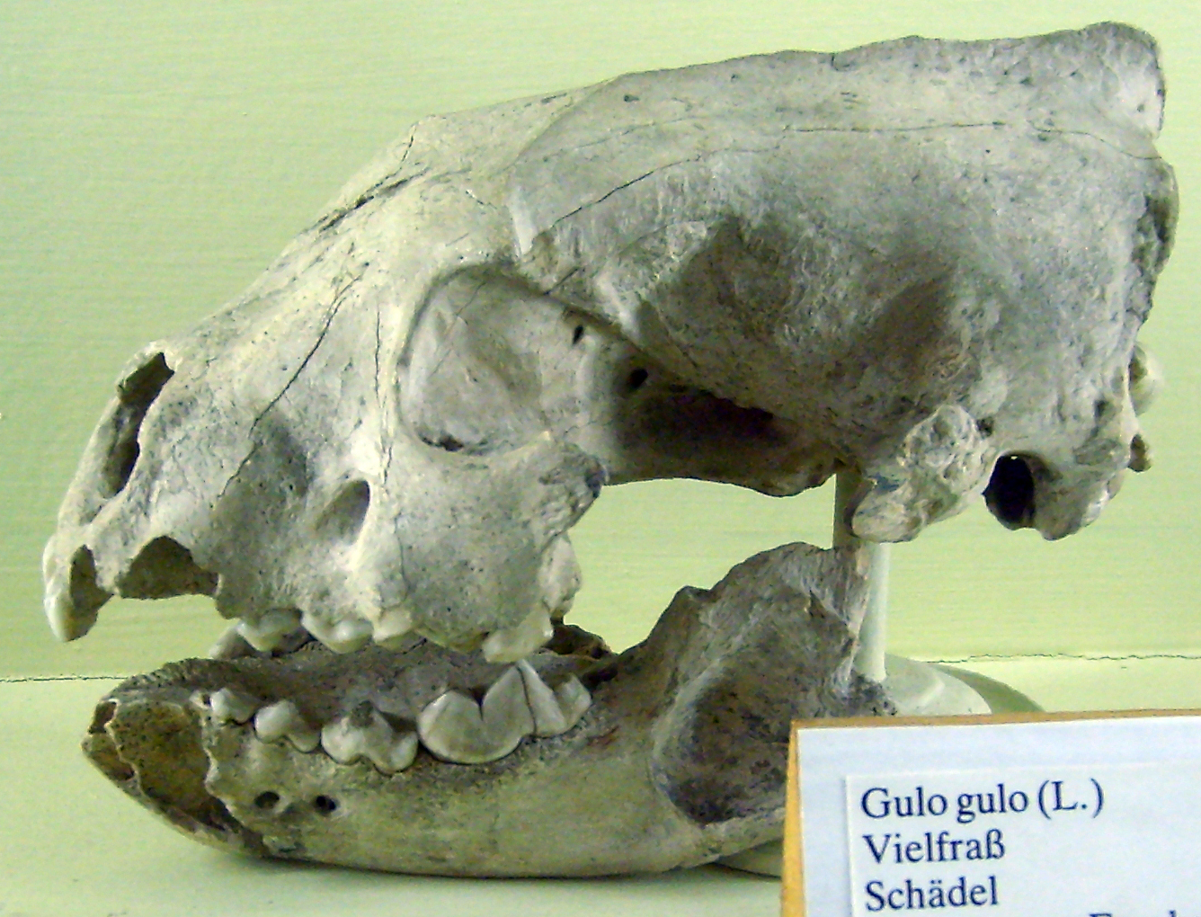
The wolverine (), (''Gulo gulo''; ''Gulo'' is Latin for "gluttony, glutton"), also referred to as the glutton, carcajou, or quickhatch (from East Cree, ''kwiihkwahaacheew''), is the largest land-dwelling species of the family Mustelidae. It is a muscular carnivore and a solitary animal. The wolverine has a reputation for ferocity and strength out of proportion to its size, with the documented ability to kill prey many times larger than itself. The wolverine is found primarily in remote reaches of the Northern Taiga, boreal forests and subarctic and alpine tundra of the Northern Hemisphere, with the greatest numbers in Northern Canada, the U.S. state of Alaska, the mainland Nordic countries of Europe, and throughout western Russia and Siberia. Its population has steadily declined since the 19th century owing to animal trapping, trapping, range reduction and habitat fragmentation. The wolverine is now essentially absent from the southern end of its range in both Europe and North ... [...More Info...] [...Related Items...] OR: [Wikipedia] [Google] [Baidu] |
Glacial Moraine
A moraine is any accumulation of unconsolidated debris (regolith and rock), sometimes referred to as glacial till, that occurs in both currently and formerly glaciated regions, and that has been previously carried along by a glacier or ice sheet. It may consist of partly rounded particles ranging in size from boulders (in which case it is often referred to as boulder clay) down to gravel and sand, in a groundmass of finely-divided clayey material sometimes called glacial flour. Lateral moraines are those formed at the side of the ice flow, and terminal moraines were formed at the foot, marking the maximum advance of the glacier. Other types of moraine include ground moraines (till-covered areas forming sheets on flat or irregular topography) and medial moraines (moraines formed where two glaciers meet). Etymology The word ''moraine'' is borrowed from French , which in turn is derived from the Savoyard Italian ("mound of earth"). ''Morena'' in this case was derived from Proven� ... [...More Info...] [...Related Items...] OR: [Wikipedia] [Google] [Baidu] |
Calgary Ski Club
Calgary ( ) is the largest city in the western Canadian province of Alberta and the largest metro area of the three Prairie Provinces. As of 2021, the city proper had a population of 1,306,784 and a metropolitan population of 1,481,806, making it the third-largest city and fifth-largest metropolitan area in Canada. Calgary is situated at the confluence of the Bow River and the Elbow River in the south of the province, in the transitional area between the Rocky Mountain Foothills and the Canadian Prairies, about east of the front ranges of the Canadian Rockies, roughly south of the provincial capital of Edmonton and approximately north of the Canada–United States border. The city anchors the south end of the Statistics Canada-defined urban area, the Calgary–Edmonton Corridor. Calgary's economy includes activity in the energy, financial services, film and television, transportation and logistics, technology, manufacturing, aerospace, health and wellness, retail, an ... [...More Info...] [...Related Items...] OR: [Wikipedia] [Google] [Baidu] |


