|
Punta De Tarifa
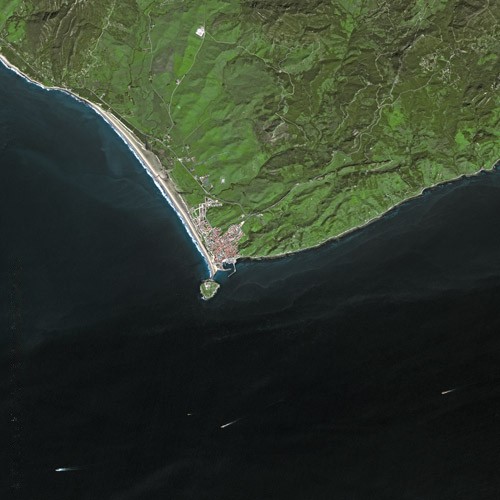
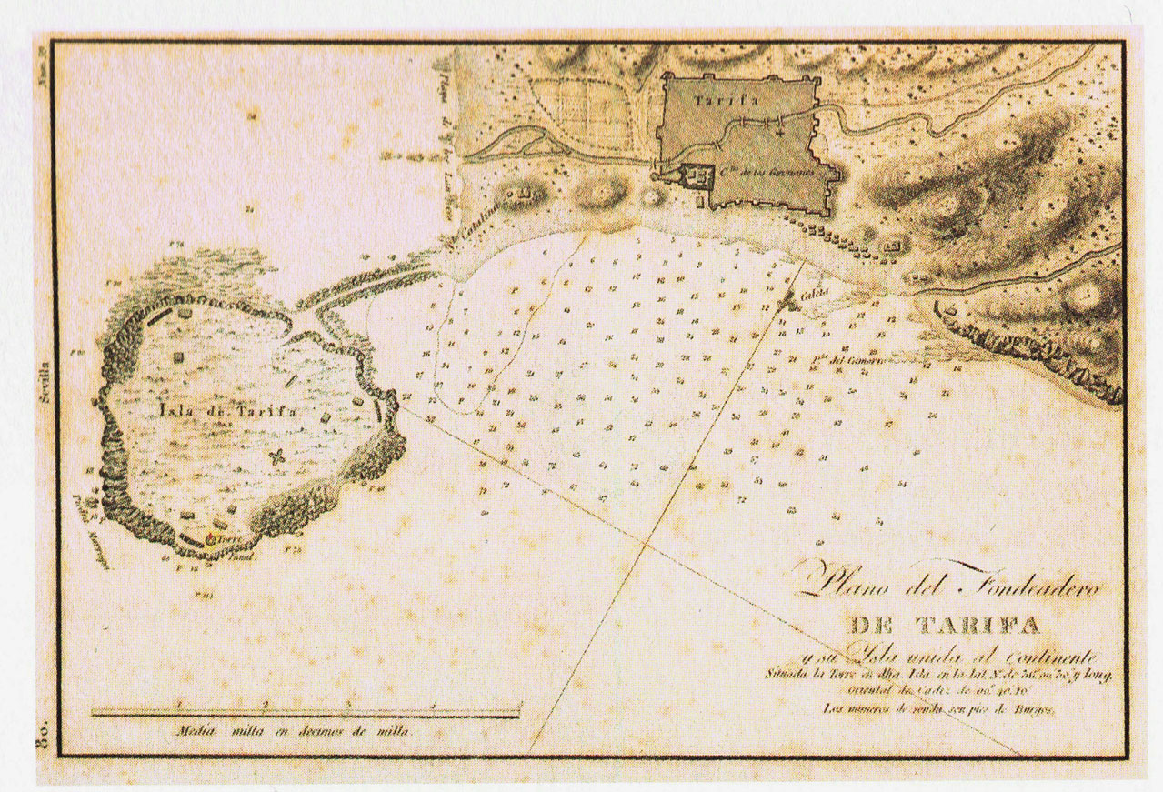
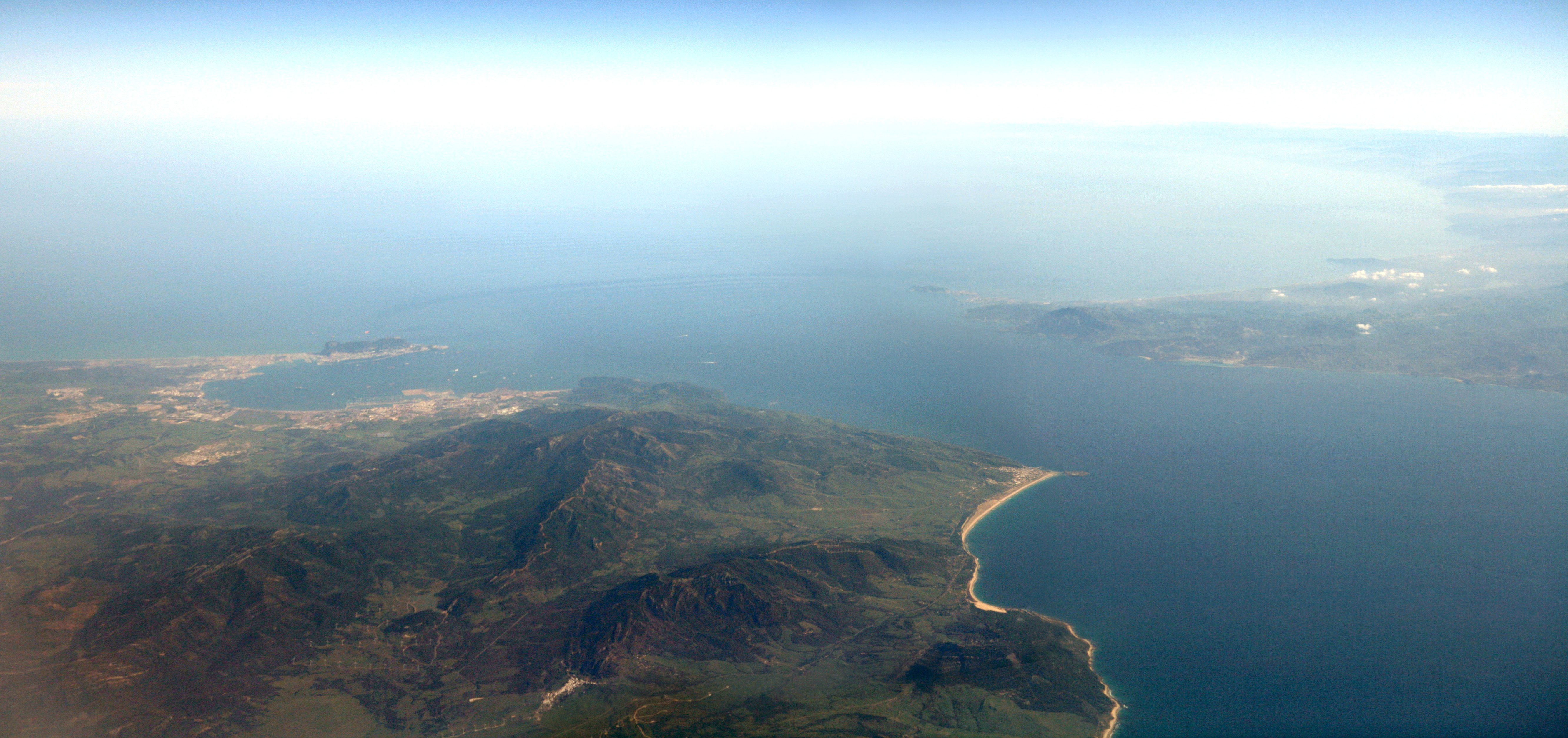
Punta de Tarifa or Punta Marroquí (Tarifa Point or Moroccan Point) is the southernmost point of the Iberian Peninsula and Continental Europe. It is located in the province of Cádiz and the autonomous community of Andalusia on the Atlantic end of the Straits of Gibraltar. The coast of Morocco can be seen from this point. The point is the southeastern tip of the former island, known as Isla de Tarifa or Isla de Las Palomas, located offshore and now connected to the mainland by a causeway. The island was occupied by a military installation between the 1930s and 2001. The name of Tarifa, both for the island and for the municipality, originates from Tarif ibn Malik, who in 711 started here the Islamic conquest of Hispania. References External links * Ferrer-Gallardo, X., Albet-Mas, A., & Espiñeira, K. (2014). The borderscape of Punta Tarifa: concurrent invisibilisation practices at Europe’s ultimate peninsula. cultural geographies, 1474474014547336.http://cgj.sagepub.com/con ... [...More Info...] [...Related Items...] OR: [Wikipedia] [Google] [Baidu] |
Tarifa SPOT 1165
Tarifa (, Arabic: طريفة) is a Spanish municipality in the province of Cádiz, Andalusia. Located at the southernmost end of the Iberian Peninsula, it is primarily known as one of the world's most popular destinations for windsports. Tarifa lies on the Costa de la Luz ("coast of light") and across the Strait of Gibraltar facing Morocco. Besides the city proper, the municipality also comprises several villages, including Tahivilla, Facinas, and Bolonia. History It was thought that Tarifa was once the site of the Roman settlement of Julia Transducta (also known as Julia Joza, or just Transducta). However, that settlement is now thought to have been where Algeciras now stands, while there is strong evidence that Casas de Porro, Valdevaqueros (Tarifa) was the site of the settlement of Mellaria. Tarifa was given its present name after the attack of Tarif ibn Malik in 710, a Berber military commander of Musa bin Nusayr. The village of Bolonia near Tarifa was also populated in ... [...More Info...] [...Related Items...] OR: [Wikipedia] [Google] [Baidu] |
Morocco
Morocco (),, ) officially the Kingdom of Morocco, is the westernmost country in the Maghreb region of North Africa. It overlooks the Mediterranean Sea to the north and the Atlantic Ocean to the west, and has land borders with Algeria to the east, and the disputed territory of Western Sahara to the south. Mauritania lies to the south of Western Sahara. Morocco also claims the Spanish exclaves of Ceuta, Melilla and Peñón de Vélez de la Gomera, and several small Spanish-controlled islands off its coast. It spans an area of or , with a population of roughly 37 million. Its official and predominant religion is Islam, and the official languages are Arabic and Berber; the Moroccan dialect of Arabic and French are also widely spoken. Moroccan identity and culture is a mix of Arab, Berber, and European cultures. Its capital is Rabat, while its largest city is Casablanca. In a region inhabited since the Paleolithic Era over 300,000 years ago, the first Moroccan s ... [...More Info...] [...Related Items...] OR: [Wikipedia] [Google] [Baidu] |
Tourism In Spain
Tourism in Spain is a major contributor to national economic life, contributing to about 11.8% of Spain's GDP (in 2017). Ever since the 1960s and 1970s, the country has been a popular destination for summer holidays, especially with large numbers of tourists from the United Kingdom, Ireland, Turkey, France, Germany, Italy, the Benelux, and the United States, among others. Accordingly, Spain's foreign tourist industry has grown into the second-biggest in the world. In 2019, Spain was the second most visited country in the world, recording 83.7 million tourists which marked the seventh consecutive year of record-beating numbers. Due to the coronavirus pandemic, in the first eleven months of year 2020 only 18.3 million tourists visited Spain. These dramatic figures are devastating for the tourism sector and are a reflection of what will be the worst year for this industry in terms of income ever recorded. Spain ranks first among 140 countries in the biannual Travel and Tourism ... [...More Info...] [...Related Items...] OR: [Wikipedia] [Google] [Baidu] |
Landforms Of Andalusia
A landform is a natural or anthropogenic land feature on the solid surface of the Earth or other planetary body. Landforms together make up a given terrain, and their arrangement in the landscape is known as topography. Landforms include hills, mountains, canyons, and valleys, as well as shoreline features such as bays, peninsulas, and seas, including submerged features such as mid-ocean ridges, volcanoes, and the great ocean basins. Physical characteristics Landforms are categorized by characteristic physical attributes such as elevation, slope, orientation, stratification, rock exposure and soil type. Gross physical features or landforms include intuitive elements such as berms, mounds, hills, ridges, cliffs, valleys, rivers, peninsulas, volcanoes, and numerous other structural and size-scaled (e.g. ponds vs. lakes, hills vs. mountains) elements including various kinds of inland and oceanic waterbodies and sub-surface features. Mountains, hills, plateaux, and plains are t ... [...More Info...] [...Related Items...] OR: [Wikipedia] [Google] [Baidu] |
Headlands Of Spain
A headland, also known as a head, is a coastal landform, a point of land usually high and often with a sheer drop, that extends into a body of water. It is a type of promontory. A headland of considerable size often is called a Cape (geography), cape.Whittow, John (1984). ''Dictionary of Physical Geography''. London: Penguin, 1984, pp. 80, 246. . Headlands are characterised by high, breaking Wave, waves, Rocky shore, rocky shores, intense erosion, and steep sea cliffs, sea cliff. Headlands and Bay, bays are often found on the same coastline. A bay is flanked by land on three sides, whereas a headland is flanked by water on three sides. Headlands and bays form on discordant coastlines, where bands of rock of alternating resistance run perpendicular to the coast. Bays form when weak (less resistant) rocks (such as Sand, sands and Clay, clays) are eroded, leaving bands of stronger (more resistant) rocks (such as chalk, limestone, and granite) forming a headland, or peninsula. Through ... [...More Info...] [...Related Items...] OR: [Wikipedia] [Google] [Baidu] |
Umayyad Conquest Of Hispania
The Umayyad conquest of Hispania, also known as the Umayyad conquest of the Visigothic Kingdom, was the initial expansion of the Umayyad Caliphate over Hispania (in the Iberian Peninsula) from 711 to 718. The conquest resulted in the decline of the Visigothic Kingdom and the establishment of the Umayyad Wilayah of Al-Andalus. During the caliphate of the sixth Umayyad caliph al-Walid I (), forces led by Tariq ibn Ziyad disembarked in early 711 in Gibraltar at the head of an army consisting of Berbers from north Africa. After defeating the Visigothic king Roderic at the decisive Battle of Guadalete, Tariq was reinforced by an Arab force led by his superior ''wali'' Musa ibn Nusayr and continued northward. By 717, the combined Arab-Berber force had crossed the Pyrenees into Septimania. They occupied further territory in Gaul until 759. Background The historian al-Tabari transmits a tradition attributed to the Caliph Uthman who stated that the road to Constantinople was throug ... [...More Info...] [...Related Items...] OR: [Wikipedia] [Google] [Baidu] |
Tarif Ibn Malik
Tarif ibn Malik ( ar, طريف بن مالك) was a commander under Tariq ibn Ziyad, the Berber, Muslim and Umayyad general who led the conquest of Visigothic Hispania in 711. Historical sources disagree on whether he was of a Berber or an Arab origin. In July 710 CE, Tariq sent Tarif on a raid to test the southern coastline of the Iberian peninsula. According to legend he was aided by Julian, count of Ceuta, as a guide and emissary. Of this raid, Edward Gibbon writes: "One hundred Arabs and four hundred Africans passed over, in four vessels, from Tangier or Ceuta; the place of their descent on the opposite shore of the strait is marked by the name of Tarif their chief" which today is the city of Tarifa. They proceeded from there to reconnoiter the terrain along the coast as a possible entry point for a larger attack, traversing "eighteen miles through a hilly country to the castle and town of Julian; on which (it is still called Algezire) they bestowed the name of the Green I ... [...More Info...] [...Related Items...] OR: [Wikipedia] [Google] [Baidu] |
Tarifa
Tarifa (, Arabic: طريفة) is a Spanish municipality in the province of Cádiz, Andalusia. Located at the southernmost end of the Iberian Peninsula, it is primarily known as one of the world's most popular destinations for windsports. Tarifa lies on the Costa de la Luz ("coast of light") and across the Strait of Gibraltar facing Morocco. Besides the city proper, the municipality also comprises several villages, including Tahivilla, Facinas, and Bolonia. History It was thought that Tarifa was once the site of the Roman settlement of Julia Transducta (also known as Julia Joza, or just Transducta). However, that settlement is now thought to have been where Algeciras now stands, while there is strong evidence that Casas de Porro, Valdevaqueros (Tarifa) was the site of the settlement of Mellaria. Tarifa was given its present name after the attack of Tarif ibn Malik in 710, a Berber military commander of Musa bin Nusayr. The village of Bolonia near Tarifa was also populated i ... [...More Info...] [...Related Items...] OR: [Wikipedia] [Google] [Baidu] |
Isla De Las Palomas
Isla de Las Palomas is an island opposite the town of Tarifa at the southern end of the Punta de Tarifa at the southernmost point of the Iberian Peninsula and continental Europe. The island has been connected to the mainland by causeway A causeway is a track, road or railway on the upper point of an embankment across "a low, or wet place, or piece of water". It can be constructed of earth, masonry, wood, or concrete. One of the earliest known wooden causeways is the Sweet Tra ... since 1808. References Tarifa Islands of Spain Landforms of Andalusia {{Anda ... [...More Info...] [...Related Items...] OR: [Wikipedia] [Google] [Baidu] |
Encyclopædia Britannica
The (Latin for "British Encyclopædia") is a general knowledge English-language encyclopaedia. It is published by Encyclopædia Britannica, Inc.; the company has existed since the 18th century, although it has changed ownership various times through the centuries. The encyclopaedia is maintained by about 100 full-time editors and more than 4,000 contributors. The 2010 version of the 15th edition, which spans 32 volumes and 32,640 pages, was the last printed edition. Since 2016, it has been published exclusively as an online encyclopaedia. Printed for 244 years, the ''Britannica'' was the longest running in-print encyclopaedia in the English language. It was first published between 1768 and 1771 in the Scottish capital of Edinburgh, as three volumes. The encyclopaedia grew in size: the second edition was 10 volumes, and by its fourth edition (1801–1810) it had expanded to 20 volumes. Its rising stature as a scholarly work helped recruit eminent con ... [...More Info...] [...Related Items...] OR: [Wikipedia] [Google] [Baidu] |
Extreme Points Of Spain
This is a list of the extreme points of Spain — the points that are farther north, south, east or west than any other location. Spain * Northernmost Point — Punta de Estaca de Bares, Mañón, Corunna at * Southernmost Point — Punta de La Restinga, El Pinar del Hierro, Santa Cruz de Tenerife at * Westernmost Point — Punta de la Orchilla, Frontera, Santa Cruz de Tenerife at * Easternmost Point — La Mola Island, Mahón, Balearic Islands at * Highest Point — El Teide 3,718 m, Tenerife, Santa Cruz de Tenerife * Point furthest from the coast (Iberian Pole of Inaccessibility) at Otero, Toledo Spanish mainland * Northernmost Point — Punta de Estaca de Bares, Corunna at * Southernmost Point — Punta de Tarifa, Cádiz at * Westernmost Point — Cape Touriñán, Corunna at * Easternmost Point — Cap de Creus, Gerona at * Centre of the Península is reputedly assigned to Cerro de los Ángeles in Getafe (16 km ... [...More Info...] [...Related Items...] OR: [Wikipedia] [Google] [Baidu] |
Strait Of Gibraltar
The Strait of Gibraltar ( ar, مضيق جبل طارق, Maḍīq Jabal Ṭāriq; es, Estrecho de Gibraltar, Archaic: Pillars of Hercules), also known as the Straits of Gibraltar, is a narrow strait that connects the Atlantic Ocean to the Mediterranean Sea and separates the Iberian Peninsula in Europe from Morocco in Africa. The two continents are separated by of ocean at the Strait's narrowest point between Point Marroquí in Spain and Point Cires in Morocco. Ferries cross between the two continents every day in as little as 35 minutes. The Strait's depth ranges between which possibly interacted with the lower mean sea level of the last major glaciation 20,000 years ago when the level of the sea is believed to have been lower by . The strait lies in the territorial waters of Morocco, Spain, and the British overseas territory of Gibraltar. Under the United Nations Convention on the Law of the Sea, foreign vessels and aircraft have the freedom of navigation and overflight t ... [...More Info...] [...Related Items...] OR: [Wikipedia] [Google] [Baidu] |

.jpg)

.jpg)


