|
Punta Eugenia
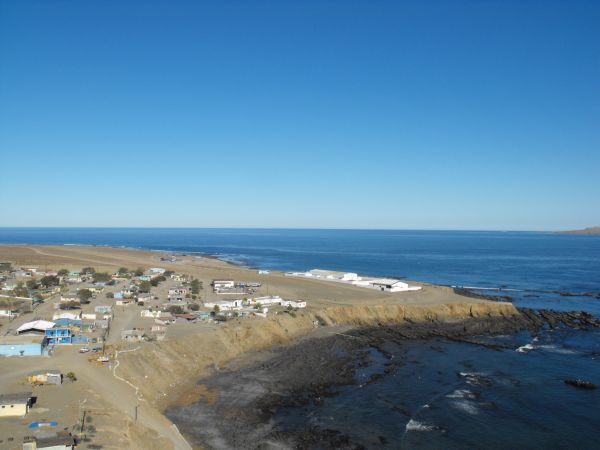
Punta Eugenia is a headland in the Mulegé Municipality. It marks the Western tip of the Vizcaíno Peninsula, thus being the westernmost point on the mainland of the state of Baja California Sur. It belongs to the larger area of El Vizcaíno Biosphere Reserve; it is separated from the mainland of the Baja Peninsula by the Vizcaíno Desert. Infrastructural developments, like the completion of the Vizcaíno-Bahía Tortugas Highway recently allowed for better integration of the traditionally secluded area (Punta Eugenia can be accessed from Bahía Tortugas by a dirt road). Touristically, the area of Punta Eugenia is still largely unexploited. The settlement Punta Eugenia, with 19 inhabitants in 2017, is traditionally populated by native and seasonally recruited fishermen and their families. Fishing industry in the Vizcaíno region annually produces thousands of tons of various species, that are mostly exported to Asia and the North American market. To the Northwest of Punta Eugenia ... [...More Info...] [...Related Items...] OR: [Wikipedia] [Google] [Baidu] |
Cedros
Cedros, Portuguese and Spanish for ''cedars'', may refer to the following places: Honduras * Cedros, Francisco Morazán, a municipality in the Department of Francisco Morazán Mexico *Cedros Island, an island in the State of Baja California Portugal *Cedros (Horta), a civil parish in the municipality of Horta, island of Faial, Azores *Cedros (Santa Cruz das Flores), a civil parish in the municipality of Santa Cruz das Flores, island of Flores, Azores Trinidad and Tobago *Cedros, Trinidad and Tobago The coastal area known as Cedros lies on a peninsula at the South-Western end of the island of Trinidad. Located at the tip of the peninsula, Cedros or Bonasse as it is more commonly known especially on maps, lies mere miles off the coast of Venez ..., the southwestern peninsula of the island of Trinidad, as well as a town on that peninsula Cuba * Los Cedros, Santiago de Cuba, a hamlet in Palma Soriano {{geodis ... [...More Info...] [...Related Items...] OR: [Wikipedia] [Google] [Baidu] |
Cedros Island
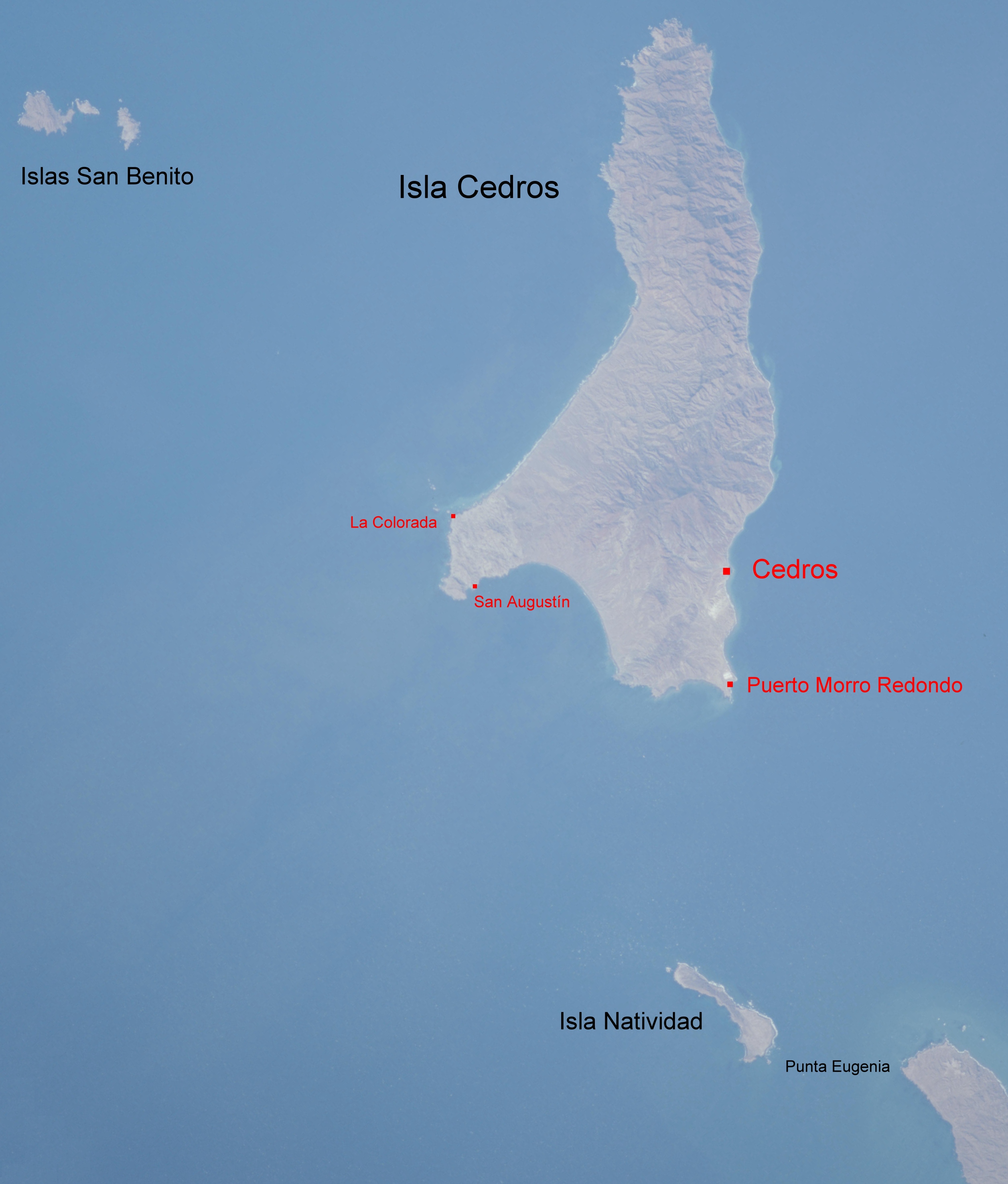
Cedros Island (''Isla de Cedros'', "island of cedars" in Spanish) is an island in the Pacific Ocean belonging to the state of Baja California, Mexico. The dry and rocky island had a population of 1,350 in 2005 and has an area of which includes the area of several small nearby islands. Cedros Island is mountainous, reaching a maximum elevation of . The economy is based on commercial fishing and salt production. Cedros has a distinctive flora and the traces of some of the earliest human beings in the New World. The ocean around the island is popular with sport fishermen. There was human presence of the island already about 11,000 years ago. The American Indian inhabitants when the island was first visited by Spanish explorers in the 16th century called it Huamalgua, the "Island of Fogs." The Indian inhabitants have been given the name Huamalgueños by modern day scholars. They were relocated to the mainland of Baja California by Jesuit missionaries in 1732 and ceased to exist a ... [...More Info...] [...Related Items...] OR: [Wikipedia] [Google] [Baidu] |
Headlands Of Mexico
A headland, also known as a head, is a coastal landform, a point of land usually high and often with a sheer drop, that extends into a body of water. It is a type of promontory. A headland of considerable size often is called a cape.Whittow, John (1984). ''Dictionary of Physical Geography''. London: Penguin, 1984, pp. 80, 246. . Headlands are characterised by high, breaking waves, rocky shores, intense erosion, and steep sea cliff. Headlands and bays are often found on the same coastline. A bay is flanked by land on three sides, whereas a headland is flanked by water on three sides. Headlands and bays form on discordant coastlines, where bands of rock of alternating resistance run perpendicular to the coast. Bays form when weak (less resistant) rocks (such as sands and clays) are eroded, leaving bands of stronger (more resistant) rocks (such as chalk, limestone, and granite) forming a headland, or peninsula. Through the deposition of sediment within the bay and the erosion of the ... [...More Info...] [...Related Items...] OR: [Wikipedia] [Google] [Baidu] |
Fish
Fish are aquatic, craniate, gill-bearing animals that lack limbs with digits. Included in this definition are the living hagfish, lampreys, and cartilaginous and bony fish as well as various extinct related groups. Approximately 95% of living fish species are ray-finned fish, belonging to the class Actinopterygii, with around 99% of those being teleosts. The earliest organisms that can be classified as fish were soft-bodied chordates that first appeared during the Cambrian period. Although they lacked a true spine, they possessed notochords which allowed them to be more agile than their invertebrate counterparts. Fish would continue to evolve through the Paleozoic era, diversifying into a wide variety of forms. Many fish of the Paleozoic developed external armor that protected them from predators. The first fish with jaws appeared in the Silurian period, after which many (such as sharks) became formidable marine predators rather than just the prey of arthropods. Mos ... [...More Info...] [...Related Items...] OR: [Wikipedia] [Google] [Baidu] |
Phylogeography
Phylogeography is the study of the historical processes that may be responsible for the past to present geographic distributions of genealogical lineages. This is accomplished by considering the geographic distribution of individuals in light of genetics, particularly population genetics. This term was introduced to describe geographically structured genetic signals within and among species. An explicit focus on a species' biogeography/biogeographical past sets phylogeography apart from classical population genetics and phylogenetics. Past events that can be inferred include population expansion, population bottlenecks, vicariance, dispersal, and migration. Recently developed approaches integrating coalescent theory or the genealogical history of alleles and distributional information can more accurately address the relative roles of these different historical forces in shaping current patterns. Development The term phylogeography was first used by John Avise in his 1987 work '' ... [...More Info...] [...Related Items...] OR: [Wikipedia] [Google] [Baidu] |
Eddy (fluid Dynamics)
In fluid dynamics, an eddy is the swirling of a fluid and the reverse current created when the fluid is in a turbulent flow regime. The moving fluid creates a space devoid of downstream-flowing fluid on the downstream side of the object. Fluid behind the obstacle flows into the void creating a swirl of fluid on each edge of the obstacle, followed by a short reverse flow of fluid behind the obstacle flowing upstream, toward the back of the obstacle. This phenomenon is naturally observed behind large emergent rocks in swift-flowing rivers. An eddy is a movement of fluid that deviates from the general flow of the fluid. An example for an eddy is a vortex which produces such deviation. However, there are other types of eddies that are not simple vortices. For example, a Rossby wave is an eddy which is an undulation that is a deviation from mean flow, but doesn't have the local closed streamlines of a vortex. Swirl and eddies in engineering The propensity of a fluid to swirl is used ... [...More Info...] [...Related Items...] OR: [Wikipedia] [Google] [Baidu] |
Ocean Current
An ocean current is a continuous, directed movement of sea water generated by a number of forces acting upon the water, including wind, the Coriolis effect, breaking waves, cabbeling, and temperature and salinity differences. Depth contours, shoreline configurations, and interactions with other currents influence a current's direction and strength. Ocean currents are primarily horizontal water movements. An ocean current flows for great distances and together they create the global conveyor belt, which plays a dominant role in determining the climate of many of Earth’s regions. More specifically, ocean currents influence the temperature of the regions through which they travel. For example, warm currents traveling along more temperate coasts increase the temperature of the area by warming the sea breezes that blow over them. Perhaps the most striking example is the Gulf Stream, which makes northwest Europe much more temperate for its high latitude compared to other areas at ... [...More Info...] [...Related Items...] OR: [Wikipedia] [Google] [Baidu] |
Islas San Benito
The Islas San Benito lie in the Pacific Ocean off the west coast of the Mexican state of Baja California, 25 km west of Cedros Island. They are part of the Cedros Island ''delegación'', a subdivision of Ensenada (municipality), Baja California. The group consists of three barren islands, with a total area of 3.899 km2, and is surrounded by rocks and patches of kelp. The census of 2001 recorded a population of two on ''Benito del Oeste'' (West Benito); the other islands are uninhabited. Geography and ecology ''Benito del Oeste'' (West Benito, 2.6 km2) is the westernmost and largest island of the group. It appears as a plateau with a mound rising 600 ft (202 m) high near the center. A lighthouse tower, 4 m high, stands in the southern part of the island. The main lighthouse, a prominent, 17 m high tower with a dwelling, stands near the northwest extremity of the island. Rocas Pinaculo, two steep-to rocks, lie 1.6 km west of Benito del Oeste. ''Benito del ... [...More Info...] [...Related Items...] OR: [Wikipedia] [Google] [Baidu] |
Isla Natividad
Isla Natividad is an island in the Pacific Ocean 6 km west off Punta Eugenia, the northwestern headland of the Mexican state of Baja California Sur. 200 meters off its northwestern end lies Roca María at , with an area of 0.074 km2. Isla Natividad is separated from the mainland at Punta Eugenia by Canal de Dewey (Dewey's Channel), and from Cedros Island (Baja California), which is 15 km to the north, by Canal de Keller (Canal Kellett). The island is part of Bahía Tortugas ''delegación'' of Mulegé municipality. It is 8.655 km2 in area. At the 2001 census, the island had a population of 384, centered in Natividad, a community of abalone, lobster, and clam fishermen, at the southeastern end (). Connection to the mainland is facilitated by an airstrip. There is a lighthouse in the northern part. Geography and ecology It has steep rocky shores fringed by rocks and kelp except for a small sandy beach towards the mainland. The island is barren and hilly wi ... [...More Info...] [...Related Items...] OR: [Wikipedia] [Google] [Baidu] |
Headland
A headland, also known as a head, is a coastal landform, a point of land usually high and often with a sheer drop, that extends into a body of water. It is a type of promontory. A headland of considerable size often is called a cape.Whittow, John (1984). ''Dictionary of Physical Geography''. London: Penguin, 1984, pp. 80, 246. . Headlands are characterised by high, breaking waves, rocky shores, intense erosion, and steep sea cliff. Headlands and bays are often found on the same coastline. A bay is flanked by land on three sides, whereas a headland is flanked by water on three sides. Headlands and bays form on discordant coastlines, where bands of rock of alternating resistance run perpendicular to the coast. Bays form when weak (less resistant) rocks (such as sands and clays) are eroded, leaving bands of stronger (more resistant) rocks (such as chalk, limestone, and granite) forming a headland, or peninsula. Through the deposition of sediment within the bay and the erosion of the ... [...More Info...] [...Related Items...] OR: [Wikipedia] [Google] [Baidu] |
Dirt Road
A dirt road or track is a type of unpaved road not paved with asphalt, concrete, brick, or stone; made from the native material of the land surface through which it passes, known to highway engineers as subgrade material. Dirt roads are suitable for vehicles; a narrower path for pedestrians, animals, and possibly small vehicles would be called a dirt track—the distinction is not well-defined. Unpaved roads with a harder surface made by the addition of material such as gravel and aggregate (stones), might be referred to as dirt roads in common usage but are distinguished as improved roads by highway engineers. (Improved unpaved roads include gravel roads, laterite roads, murram roads and macadamized roads.) Compared to a gravel road, a dirt road is not usually graded regularly to produce an enhanced camber to encourage rainwater to drain off the road, and drainage ditches at the sides may be absent. They are unlikely to have embankments through low-lying areas. This lea ... [...More Info...] [...Related Items...] OR: [Wikipedia] [Google] [Baidu] |
Bahía Tortugas
Baja California Sur (; 'South Lower California'), officially the Free and Sovereign State of Baja California Sur ( es, Estado Libre y Soberano de Baja California Sur), is the least populated state and the 31st admitted state of the 32 federal entities which comprise the 31 States of Mexico. It is also the ninth-largest Mexican state in terms of area. Before becoming a state on 8 October 1974, the area was known as the ''El Territorio Sur de Baja California'' ("South Territory of Lower California"). It has an area of , or 3.57% of the land mass of Mexico, and occupies the southern half of the Baja California Peninsula, south of the 28th parallel, plus the uninhabited Rocas Alijos in the Pacific Ocean. It is bordered to the north by the state of Baja California, to the west by the Pacific Ocean, and to the east by the Gulf of California. The state has maritime borders with Sonora and Sinaloa to the east, across the Gulf of California. The state is home to the tourist resorts of ... [...More Info...] [...Related Items...] OR: [Wikipedia] [Google] [Baidu] |

_(20423086215).jpg)


