|
Punial Tehsil
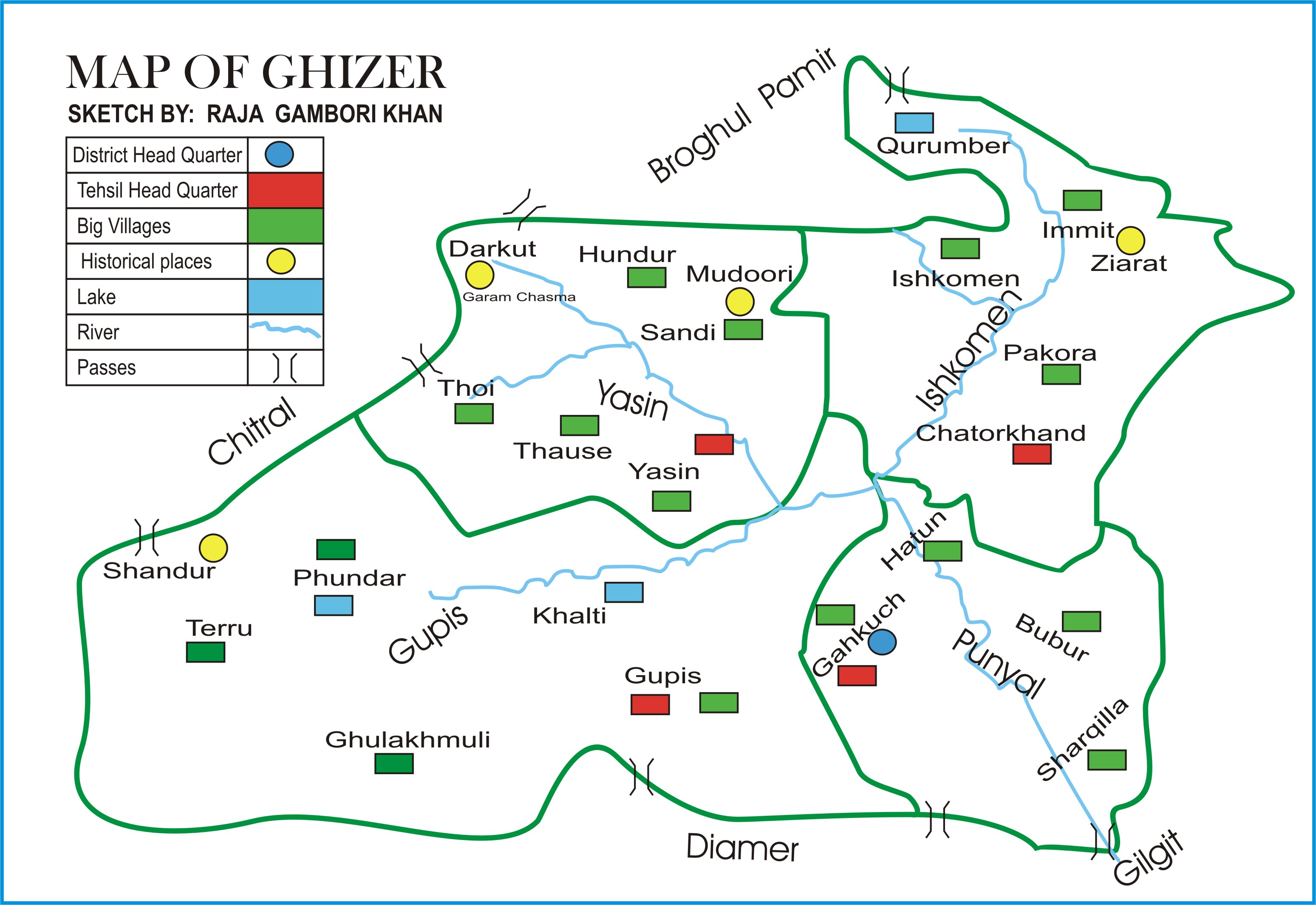
The valley of Punial (Urdu: پونیال) is situated in Ghizer District in the Gilgit-Baltistan, Pakistan, where hundreds of thousands of tourists visit annually. Punial is a mountainous valley situated at an elevation of about 5000–9000 feet. It has pleasant weather and a hospitable populace. The territory of Punial has an area of about . Villages of Punial Valley Gulapur, Sher Qillah, Dalnati, Hamuchal, Gohar Abad (Gutmsas), Japukay, Gitch, Dass Japukay, Singal(Heart of Punial), Thingdass, Gulmuti, Buber (Bubur, Minipunial), Gurunjur, Gahkuch bala, Gahkuch pine, Silpi, Damas, Ayshi, Golo Dass, Hatoon, Hasis, Haim, Birgal, Famani and Hopper. Gohar Abad, Gitch,and Thingdass are mainly part of larger Singal. History The word “Punial” is from the Shina language. It has two meanings: “fertile land” and “bucket of fruits”. Punial is related to neighbour areas of Gilgit agency. Punially people belonged to Arian “Mazdaism” ( آتش پرست ), Shina language pen ... [...More Info...] [...Related Items...] OR: [Wikipedia] [Google] [Baidu] |
Gilgit-Baltistan Map With Tehsils Labelled
Gilgit-Baltistan (; ), formerly known as the Northern Areas, is a region administered by Pakistan as an administrative territory, and constituting the northern portion of the larger Kashmir region which has been the subject of a dispute between India and Pakistan since 1947, and between India and China from somewhat later.The application of the term "administered" to the various regions of Kashmir and a mention of the Kashmir dispute is supported by the tertiary sources (a) through (d), reflecting due weight in the coverage. Although "controlled" and "held" are also applied neutrally to the names of the disputants or to the regions administered by them, as evidenced in sources (e) through (g) below, "held" is also considered politicized usage, as is the term "occupied," (see (h) below): (a) (subscription required) Quote: "Kashmir, region of the northwestern Indian subcontinent ... has been the subject of dispute between India and Pakistan since the partition of the Indian ... [...More Info...] [...Related Items...] OR: [Wikipedia] [Google] [Baidu] |
Ghizer District (2019–)
The Ghizer District ( ur, ) is one of the 14 districts of Pakistan-administered territory of Gilgit-Baltistan. The former Ghizer District that existed from 1974 to 2019 spanned the entire upper Gilgit River Valley (also known as the Ghizer River Valley). In 2019, the former district was divided into the Gupis-Yasin District in the west and the present, smaller Ghizer District in the east. The word Ghizer came from the name "Gherz" which means "refugees" in Khowar. "Gherz" is a village in Golaghmuli Valley. The Chitral State under the suzerainty of the British Raj forced some people to migrate towards Gupis, Yasin, Phander, Ishkomen and also to Punial. They were settled in the area between Chitral and Gupis. The area came to be called "Gherz" and the people "Gherzic". Ghizer District comprised Punial, Gupis, Yasen, Phander and Ishkoman Valleys. The major portion of its area was ruled over by Brooshay Rajas. Currently, the living Raja families in the District have no administrat ... [...More Info...] [...Related Items...] OR: [Wikipedia] [Google] [Baidu] |
Pakistan
Pakistan ( ur, ), officially the Islamic Republic of Pakistan ( ur, , label=none), is a country in South Asia. It is the world's List of countries and dependencies by population, fifth-most populous country, with a population of almost 243 million people, and has the world's Islam by country#Countries, second-largest Muslim population just behind Indonesia. Pakistan is the List of countries and dependencies by area, 33rd-largest country in the world by area and 2nd largest in South Asia, spanning . It has a coastline along the Arabian Sea and Gulf of Oman in the south, and is bordered by India to India–Pakistan border, the east, Afghanistan to Durand Line, the west, Iran to Iran–Pakistan border, the southwest, and China to China–Pakistan border, the northeast. It is separated narrowly from Tajikistan by Afghanistan's Wakhan Corridor in the north, and also shares a maritime border with Oman. Islamabad is the nation's capital, while Karachi is its largest city and fina ... [...More Info...] [...Related Items...] OR: [Wikipedia] [Google] [Baidu] |
Tourism In Pakistan
Tourism in Pakistan is a growing industry. In 2010, Lonely Planet termed Pakistan "tourism's 'next big thing' for more years than we care to remember". The country is geographically and ethnically diverse, and has a number of historical and cultural heritage sites. Condé Nast Traveller ranked Pakistan The Best Holiday Destination for 2020 and also declared it the third-highest potential adventure destination in the world for 2020. As security in the country improves, tourism increases; in two years, it has increased by more than 300%. The Pakistani government had launched online visa services for 175 countries and 50 countries were offered visa on arrival, making a visit to Pakistan easier. The country received an influx of travel vloggers, who promoted the characteristics of the country, such as in the Northern Pakistan, like Hunza and Skardu. In 2018, the British Backpacker Society ranked Pakistan the world's top adventure travel destination, describing the country as "one ... [...More Info...] [...Related Items...] OR: [Wikipedia] [Google] [Baidu] |
Chitral
Chitral ( khw, , lit=field, translit=ćhitrār; ur, , translit=ćitrāl) is situated on the Chitral River in northern Khyber Pakhtunkhwa, Pakistan. It serves as the capital of the Chitral District and before that as the capital of Chitral princely state that encompassed the region until its direct incorporation into West Pakistan on 14 August 1947. It has a population of 49,780 per the 2017 census. History Gankoreneotek Grave This city was founded as the name of Qāshqār in ancient timesIt was famous Gandharan trade route at this time.Gankorineotek cemetery is also existed here. Early history The Kho Chitralis came to Chitral as part of the Indo-Aryan migration into South Asia. They settled in the northern parts of Chitral near the Torkhow and Mulkhow Region. Ancient era The existence of the Gandharan Grave Culture in Chitral, found in various grave sites scattered over its valleys, indicate its proximity towards the Gandharan culture alongside giving insigh ... [...More Info...] [...Related Items...] OR: [Wikipedia] [Google] [Baidu] |
Katur Dynasty
The Katoor dynasty (also spelled Katur and Kator) was a dynasty, which along with its collateral branches ruled the sovereign, later princely state of Chitral and its neighbours in the eastern Hindu Kush region for over 450 years, from around 1570 until 1947. At the height its power under Mehtar Aman ul-Mulk the territory controlled by the dynasty extended from Asmar in the Kunar Valley to Sher Qilla in the Gilgit valley. The Mehtar of Chitral was an influential player in the power politics of the region as he acted as an intermediary between the rulers of Badakhshan, the Yousafzai pashtuns, the Maharaja of Kashmir and later the Amir of Afghanistan. Origins The name Katoor is an ancient one and has been in use long before the ancestor of the Katoors settled in Chitral in 1520. According to one theory, Katoor was a Kushan title of nobility. Katoor also means dragon in the archaic Bashgali dialect of Kohistani. The title of Shah Katoor was given to Mohtaram Shah, the first ruler of ... [...More Info...] [...Related Items...] OR: [Wikipedia] [Google] [Baidu] |
Raja Nasir Ul Din
''Raja'' (; from , IAST ') is a royal title used for South Asian monarchs. The title is equivalent to king or princely ruler in South Asia and Southeast Asia. The title has a long history in South Asia and Southeast Asia, being attested from the Rigveda, where a ' is a ruler, see for example the ', the "Battle of Ten Kings". Raja-ruled Indian states While most of the Indian salute states (those granted a gun salute by the British Crown) were ruled by a Maharaja (or variation; some promoted from an earlier Raja- or equivalent style), even exclusively from 13 guns up, a number had Rajas: ; Hereditary salutes of 11-guns : * the Raja of Pindrawal * the Raja of Morni * the Raja of Rajouri * the Raja of Ali Rajpur * the Raja of Bilaspur * the Raja of Chamba * the Raja of Faridkot * the Raja of Jhabua * the Raja of Mandi * the Raja of Manipur * the Raja of Narsinghgarh * the Raja of Pudukkottai * the Raja of Rajgarh * the Raja of Sangli * the Raja of Sailana * the R ... [...More Info...] [...Related Items...] OR: [Wikipedia] [Google] [Baidu] |
Gahkuch
Gahkuch ( ur, ) is the capital city of Ghizer District in Gilgit-Baltistan, Pakistan. The city lies on the way to Ishkoman The Ishkoman ( ur, ) valley lies in the north of Ghizer District in Gilgit-Baltistan, Pakistan, bordering Afghanistan and the Pamir Wakhan Corridor. Its altitude ranges from 7,000 to 12,000 feet (2,100 to 3,700 m) above sea level. See also * .... It is surrounded by mountains. It is situated 72 kilometers northwest of Gilgit, the capital of Pakistan's autonomous Gilgit-Baltistan province. Pakistan's 1998 census recorded the population of Gahkuch as 10,142. References Populated places in Ghizer District {{NorthernAreas-geo-stub Cities in Pakistan ... [...More Info...] [...Related Items...] OR: [Wikipedia] [Google] [Baidu] |
Sher Qilla
''Sher Qilla'' , native_name_lang = ur , other_name = , nickname = The Fort of Lions , image_skyline = , settlement_type = Town , image_caption = Sherqilla Valley , pushpin_map = Gilgit Baltistan , pushpin_map_caption = Location in Gilgit-Baltistan , subdivision_type = Country , subdivision_name = , subdivision_type1 = Autonomous state , subdivision_name1 = Balawaristan , subdivision_type3 = District , subdivision_name3 = Ghizer , coordinates = , elevation_m = 2000 , population_as_of = , population_total = 10,000 , population_demonym = , population_footnotes = , population_density_km2 = , timezone = PS ... [...More Info...] [...Related Items...] OR: [Wikipedia] [Google] [Baidu] |
Punial State
Punial State in Pakistan was formerly a princely state (under the British it was a "Special Political District" of the Gilgit Agency and not a Princely State) in the northwest part of the Northern Areas which existed until 1974. The state bordered the Gilgit Tehsil to the south, the former princely state of Yasin to the west, Ishkoman to the north and Afghanistan (Wakhan Corridor) to the northwest. The State Had Two Capitals while ruled by two Islamic dynasties from different religious background which included the Katur Dynasty (Sunni) and Aqa Shah Dynasty (Ismaili). The state capital was the town of Sher Qila until 1889, it was soon replaced by the town of Gahkuch , after Aqa Shah Ruler His Highness Aqa Sultan Akbar Shah expanded the States boundaries by forming a small military relief force named the Punial Levi's in 1889. The area of Punial now forms the above named tehsil of Ghizer District. Punial was an independent principality for several centuries. The British g ... [...More Info...] [...Related Items...] OR: [Wikipedia] [Google] [Baidu] |


