|
Puncoviscana Formation
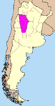
Puncoviscana Formation ( es, Formación Puncoviscana) is a formation of sedimentary and metasedimentary rocks Late Ediacaran and Lower Cambrian age, estimated at between 700 and 535 Ma, that crop out in the Argentine Northwest. Most of the formation lies in Jujuy, Salta and Tucumán Province albeit some authors extend the formation further south to the Sierras Pampeanas near Córdoba. There are various tectonic interpretations on the origin and type of sedimentary basin that accumulated Puncoviscana Formations sediments. An early interpretation was that the sediments originated from a passive marginal basin of the ancient continent Gondwana. Others suggested an intra-cratonic rift or aulacogen basin between Río de la Plata-Pampia Craton and Arequipa Massif. Yet other hypotheses revolve around the idea that the Puncoviscana Formation is related to a terrane called Pampia that accreted to Gondwana causing the closure of a sea in the way. Stratigraphy, lithology and fossils ... [...More Info...] [...Related Items...] OR: [Wikipedia] [Google] [Baidu] |
Formation (stratigraphy)
A geological formation, or simply formation, is a body of rock having a consistent set of physical characteristics (lithology) that distinguishes it from adjacent bodies of rock, and which occupies a particular position in the layers of rock exposed in a geographical region (the stratigraphic column). It is the fundamental unit of lithostratigraphy, the study of strata or rock layers. A formation must be large enough that it can be mapped at the surface or traced in the subsurface. Formations are otherwise not defined by the thickness (geology), thickness of their rock strata, which can vary widely. They are usually, but not universally, tabular in form. They may consist of a single lithology (rock type), or of alternating beds of two or more lithologies, or even a heterogeneous mixture of lithologies, so long as this distinguishes them from adjacent bodies of rock. The concept of a geologic formation goes back to the beginnings of modern scientific geology. The term was used by ... [...More Info...] [...Related Items...] OR: [Wikipedia] [Google] [Baidu] |
Mesón Group
Mesón Group ( es, Grupo Mesón) is a Cambrian to Early Ordovician sedimentary formation located in the Argentine Northwest and nearby parts of Bolivia. The group members rest unconformably on top of the Ediacaran–Cambrian Puncoviscana Formation. According to G.F. Aceñolaza, the Mesón Basin the sedimentary basin in which the Méson Group was deposited was located between the Arequipa and Río de la Plata Cratons. Stratigraphy The Mesón Group comprises three formations: Chahualmayoc Formation at the top, Lizoite Formation at the base and Campanario Formation in-between. The group is composed of sandstones, siltstones and limestone Limestone ( calcium carbonate ) is a type of carbonate sedimentary rock which is the main source of the material lime. It is composed mostly of the minerals calcite and aragonite, which are different crystal forms of . Limestone forms whe ...s. [...More Info...] [...Related Items...] OR: [Wikipedia] [Google] [Baidu] |
Aulacogen
An aulacogen is a failed arm of a triple junction. Aulacogens are a part of plate tectonics where oceanic and continental crust is continuously being created, destroyed, and rearranged on the Earth’s surface. Specifically, aulacogens are a rift zone, where new crust is formed, that is no longer active. Origin of term The term ''aulacogen'' is derived from Greek ''aulax'' 'furrow' and was suggested by the Soviet geologist Nikolay Shatsky in 1946. Formation A triple junction is the point where three tectonic plates meet; the boundaries of these plates are characterized by divergence, causing a rift zone or spreading center; a transform fault; or convergence causing subduction or uplift of crust and forming mountains. The failed arm of a triple junction can be either a transform fault that has been flooded with magma, or more commonly, an inactive rift zone. Aulacogen formation starts with the termination of an active rift zone, which leaves behind a graben-like formation. Over ... [...More Info...] [...Related Items...] OR: [Wikipedia] [Google] [Baidu] |
Rift
In geology, a rift is a linear zone where the lithosphere is being pulled apart and is an example of extensional tectonics. Typical rift features are a central linear downfaulted depression, called a graben, or more commonly a half-graben with normal faulting and rift-flank uplifts mainly on one side. Where rifts remain above sea level they form a rift valley, which may be filled by water forming a rift lake. The axis of the rift area may contain volcanic rocks, and active volcanism is a part of many, but not all, active rift systems. Major rifts occur along the central axis of most mid-ocean ridges, where new oceanic crust and lithosphere is created along a divergent boundary between two tectonic plates. ''Failed rifts'' are the result of continental rifting that failed to continue to the point of break-up. Typically the transition from rifting to spreading develops at a triple junction where three converging rifts meet over a hotspot. Two of these evolve to the poi ... [...More Info...] [...Related Items...] OR: [Wikipedia] [Google] [Baidu] |
Craton
A craton (, , or ; from grc-gre, κράτος "strength") is an old and stable part of the continental lithosphere, which consists of Earth's two topmost layers, the crust and the uppermost mantle. Having often survived cycles of merging and rifting of continents, cratons are generally found in the interiors of tectonic plates; the exceptions occur where geologically recent rifting events have separated cratons and created passive margins along their edges. Cratons are characteristically composed of ancient crystalline basement rock, which may be covered by younger sedimentary rock. They have a thick crust and deep lithospheric roots that extend as much as several hundred kilometres into Earth's mantle. Terminology The term ''craton'' is used to distinguish the stable portion of the continental crust from regions that are more geologically active and unstable. Cratons are composed of two layers: A continental ''shield'', in which the basement rock crops out at the surface ... [...More Info...] [...Related Items...] OR: [Wikipedia] [Google] [Baidu] |
Gondwana
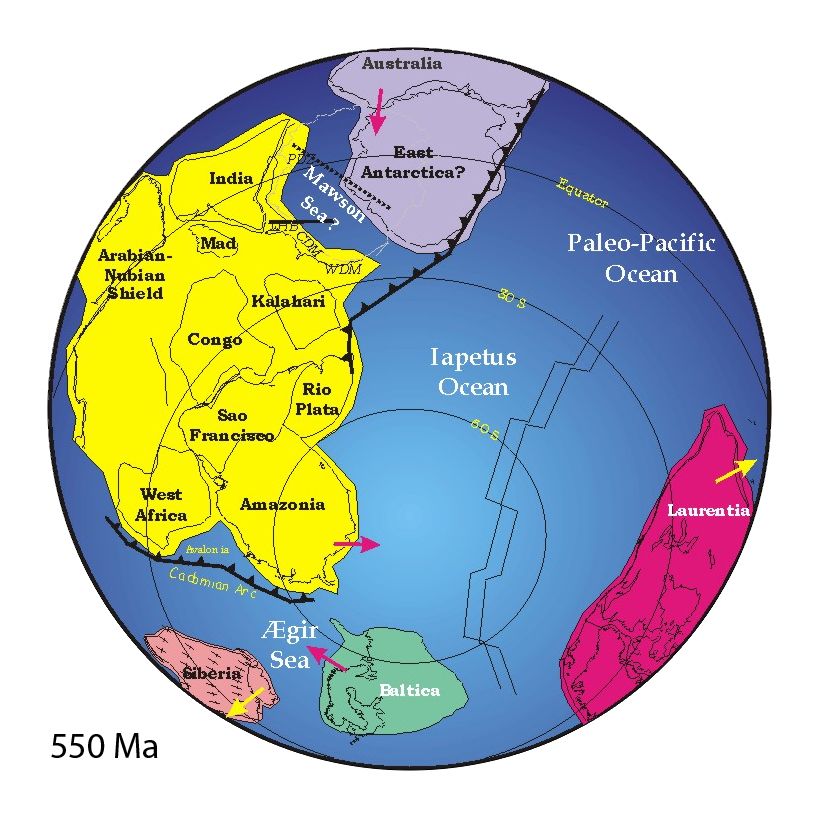
Gondwana () was a large landmass, often referred to as a supercontinent, that formed during the late Neoproterozoic (about 550 million years ago) and began to break up during the Jurassic period (about 180 million years ago). The final stages of break-up, involving the separation of Antarctica from South America (forming the Drake Passage) and Australia, occurred during the Paleogene. Gondwana was not considered a supercontinent by the earliest definition, since the landmasses of Baltica, Laurentia, and Siberia were separated from it. To differentiate it from the Indian region of the same name (see ), it is also commonly called Gondwanaland. Gondwana was formed by the accretion of several cratons. Eventually, Gondwana became the largest piece of continental crust of the Palaeozoic Era, covering an area of about , about one-fifth of the Earth's surface. During the Carboniferous Period, it merged with Laurasia to form a larger supercontinent called Pangaea. Gondwana (and Pan ... [...More Info...] [...Related Items...] OR: [Wikipedia] [Google] [Baidu] |
Passive Margin
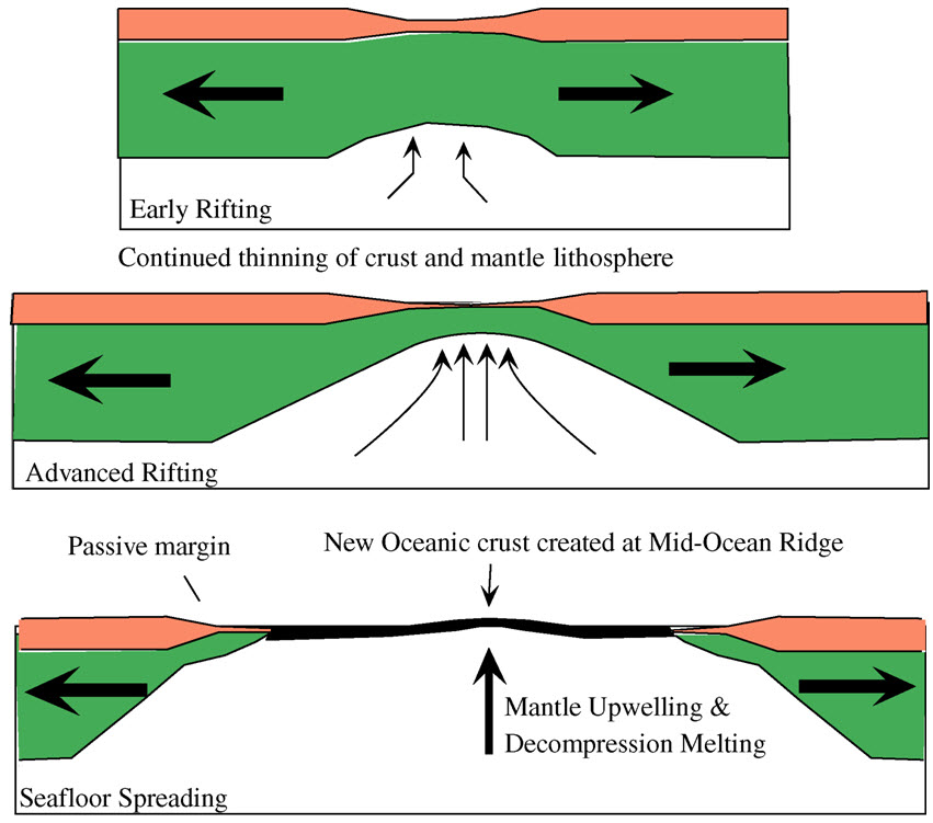
A passive margin is the transition between oceanic and continental lithosphere that is not an active plate margin. A passive margin forms by sedimentation above an ancient rift, now marked by transitional lithosphere. Continental rifting creates new ocean basins. Eventually the continental rift forms a mid-ocean ridge and the locus of extension moves away from the continent-ocean boundary. The transition between the continental and oceanic lithosphere that was originally created by rifting is known as a passive margin. Global distribution Passive margins are found at every ocean and continent boundary that is not marked by a strike-slip fault or a subduction zone. Passive margins define the region around the Arctic Ocean, Atlantic Ocean, and western Indian Ocean, and define the entire coasts of Africa, Australia, Greenland, and the Indian Subcontinent. They are also found on the east coast of North America and South America, in Western Europe and most of Antarctica. Northeas ... [...More Info...] [...Related Items...] OR: [Wikipedia] [Google] [Baidu] |
Sedimentary Basin
Sedimentary basins are region-scale depressions of the Earth's crust where subsidence has occurred and a thick sequence of sediments have accumulated to form a large three-dimensional body of sedimentary rock. They form when long-term subsidence creates a regional depression that provides Accommodation (geology), accommodation space for accumulation of sediments. Over millions or tens or hundreds of millions of years the deposition of sediment, primarily gravity-driven transportation of water-borne eroded material, acts to fill the depression. As the sediments are buried, they are subject to increasing pressure and begin the processes of compaction (geology), compaction and lithification that transform them into sedimentary rock. Sedimentary basins are created by deformation of Earth's lithosphere in diverse geological settings, usually as a result of plate tectonics, plate tectonic activity. Mechanisms of crustal deformation that lead to subsidence and sedimentary basin formati ... [...More Info...] [...Related Items...] OR: [Wikipedia] [Google] [Baidu] |
Córdoba, Argentina
Córdoba () is a city in central Argentina, in the foothills of the Punilla Valley, Sierras Chicas on the Primero River, Suquía River, about northwest of Buenos Aires. It is the capital of Córdoba Province, Argentina, Córdoba Province and the List of cities in Argentina by population, second most populous city in Argentina after Buenos Aires, with about 1.3 million inhabitants according to the 2010 census. It was founded on 6 July 1573 by Jerónimo Luis de Cabrera, who named it after Córdoba, Spain. It was one of the early Spanish colonial capitals of the region that is now Argentina (the oldest city is Santiago del Estero, founded in 1553). The National University of Córdoba is the oldest university of the country. It was founded in 1613 by the Society of Jesus, Jesuit Order. Because of this, Córdoba earned the nickname ''La Docta'' ("the learned"). Córdoba has many historical monuments preserved from Spanish colonization of the Americas, Spanish colonial rule, espe ... [...More Info...] [...Related Items...] OR: [Wikipedia] [Google] [Baidu] |
Sierras Pampeanas
The Sierras Pampeanas (also called Central Sierras or Pampas Sierras) (English: Pampas Mountains) is a geographical region of Argentina. The Sierras Pampeanas are a chain of mountains that rise sharply from the surrounding pampa region of Northwest Argentina. They run parallel to the Andes Mountains and their crest line is some east of the Andes crest line (running from 29° to 35° S latitude at about 65° W longitude). They cross into seven Argentina provinces: San Luis, San Juan, Córdoba, La Rioja, Catamarca, Santiago del Estero and Tucumán. Geography The highest point of the Sierras Pampeanas is Cerro General Belgrano (6250 m above sea level) in La Rioja, in the Sierra de Famatina. Between the mountain ranges are several salt-filled depressions. The Salinas Grandes depression is located in Cordoba, La Rioja, Catamarca and Santiago del Estero. A characteristic of many of these mountain ranges is their morphological asymmetry: the western slopes are usually ... [...More Info...] [...Related Items...] OR: [Wikipedia] [Google] [Baidu] |
Argentine Northwest
The Argentine Northwest (''Noroeste Argentino'') is a geographic and historical region of Argentina composed of the provinces of Catamarca, Jujuy, La Rioja, Salta, Santiago del Estero and Tucumán. Geography The Argentine Northwest comprises very distinct biomes, or geographical and climatic regions. From west to east they are: * The Altiplano or "Puna" * High Mountains of the Andes * Fertile valleys * Red-rock canyons and mountain passes * Humid Sub-Andean Sierras * Tropical jungles or Yungas * And the ecotone—or transitional zone—between the Yungas and the Chaco region. Besides the Yungas jungle on the eastern fringe of the region, the only fertile lands are those near the river basins, which have been irrigated extensively. Across millennia the erosive forces of these rivers has gradually created a multitude of red-rock canyons, such as the Quebrada de Humahuaca and the Valles Calchaquíes. West of these valleys the peaks of the Andes reach heights of over and the ... [...More Info...] [...Related Items...] OR: [Wikipedia] [Google] [Baidu] |
Metamorphic Rock
Metamorphic rocks arise from the transformation of existing rock to new types of rock in a process called metamorphism. The original rock (protolith) is subjected to temperatures greater than and, often, elevated pressure of or more, causing profound physical or chemical changes. During this process, the rock remains mostly in the solid state, but gradually recrystallizes to a new texture or mineral composition. The protolith may be an igneous, sedimentary, or existing metamorphic rock. Metamorphic rocks make up a large part of the Earth's crust and form 12% of the Earth's land surface. They are classified by their protolith, their chemical and mineral makeup, and their texture. They may be formed simply by being deeply buried beneath the Earth's surface, where they are subject to high temperatures and the great pressure of the rock layers above. They can also form from tectonic processes such as continental collisions, which cause horizontal pressure, friction, and distorti ... [...More Info...] [...Related Items...] OR: [Wikipedia] [Google] [Baidu] |


