|
Prince George's Plaza Station
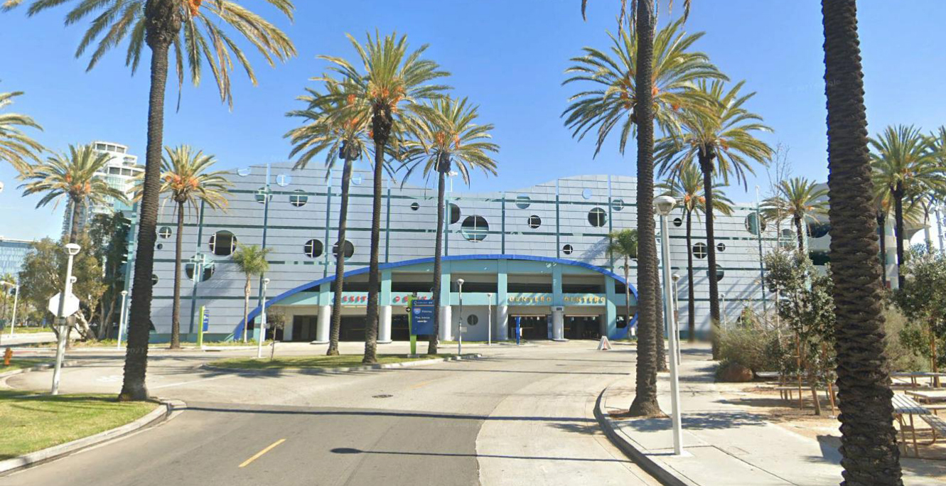
Hyattsville Crossing station is a Washington Metro station in Hyattsville, Maryland, on the Green Line. It opened on December 11, 1993, as Prince George's Plaza, referencing the nearby Prince George's Plaza, now known as The Mall at Prince Georges. The station has a unique layout in that it is an open-cut side platformed station with a parking garage directly over the tracks. History The station is located in a commercial area of Hyattsville near The Mall at Prince Georges, which, before receiving its second name in November 2004, was called Prince George's Plaza, at East-West Highway (Maryland Route 410) and Belcrest Road. Service began on December 11, 1993. Originally, only Green Line trains served the station and ran between and . Eventually, this segment of the Green Line was connected with the rest of the Green Line in September 1999. Rush hour Yellow Line trains began operating at this station on June 12, 2012, operating between Greenbelt and or . However, this servic ... [...More Info...] [...Related Items...] OR: [Wikipedia] [Google] [Baidu] |
Maryland Route 410
Maryland Route 410 (MD 410) is a state highway in the U.S. state of Maryland and known for most of its length as East–West Highway. The highway runs east to west (hence its name) for from MD 355 in Bethesda east to Pennsy Drive in Landover Hills. MD 410 serves as a major east–west commuter route through the inner northern suburbs of Washington, D.C., connecting the commercial districts of Bethesda, Silver Spring, and Hyattsville. In addition, the highway serves the industrial area of Landover Hills and the residential suburbs of Chevy Chase, Takoma Park, Chillum, Riverdale, and East Riverdale. The road also connects many of the arterial highways and freeways that head out of Washington. Additionally, it provides a highway connection to transit and commercial hubs centered around Washington Metro subway stations in Bethesda, Takoma Park, Hyattsville, Silver Spring, and New Carrollton–the latter two of which provide additional connections ... [...More Info...] [...Related Items...] OR: [Wikipedia] [Google] [Baidu] |
Green Line (Washington Metro)
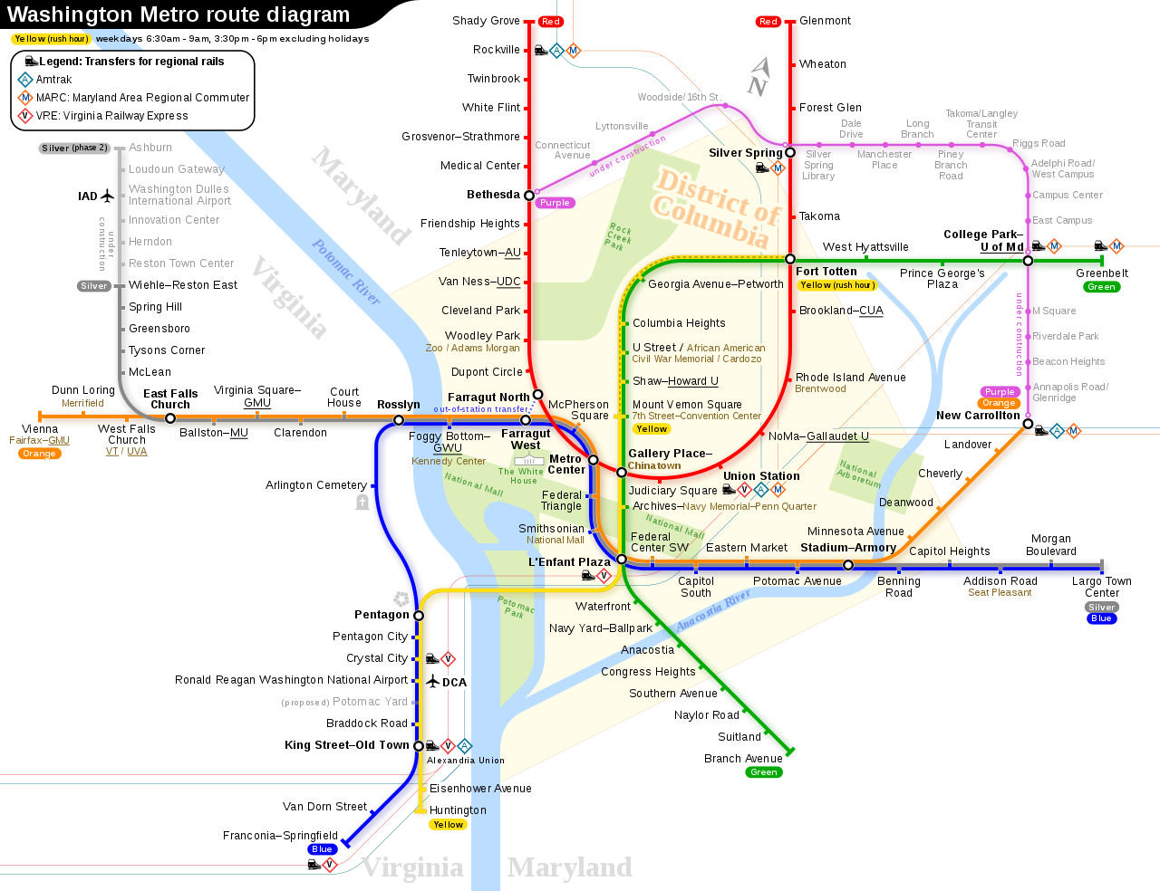
The Green Line is a rapid transit line of the Washington Metro system, consisting of 21 stations in the District of Columbia and Prince George's County, Maryland, United States. The Green Line runs from to . It was the last line in the original Metrorail plan to be constructed, and is one of three north–south lines through the city of Washington. The Green Line shares tracks with the Yellow line from to . Planning Planning for Metro began with the Mass Transportation Survey in 1955, which attempted to forecast both freeway and mass transit systems sufficient to meet the needs of the region projected for 1980. In 1959, the study's final report included two rapid transit lines which anticipated subways in downtown Washington. Because the plan called for extensive freeway construction within the District of Columbia, alarmed residents lobbied for legislation which both created a new transportation agency and blocked freeway construction. The agency, the National Capital T ... [...More Info...] [...Related Items...] OR: [Wikipedia] [Google] [Baidu] |
Stations On The Green Line (Washington Metro)
Station may refer to: Agriculture * Station (Australian agriculture), a large Australian landholding used for livestock production * Station (New Zealand agriculture), a large New Zealand farm used for grazing by sheep and cattle ** Cattle station, a cattle-rearing station in Australia or New Zealand **Sheep station, a sheep-rearing station in Australia or New Zealand Communications * Radio communication station, a radio frequency communication station of any kind, including audio, TV, and non-broadcast uses ** Radio broadcasting station, an audio station intended for reception by the general public ** Amateur radio station, a station operating on frequencies allocated for ham or other non-commercial use ** Broadcast relay station ** Ground station (or Earth station), a terrestrial radio station for extraplanetary telecommunication with satellites or spacecraft ** Television station * Courier station, a relay station in a courier system ** Station of the ''cursus publicus'', a sta ... [...More Info...] [...Related Items...] OR: [Wikipedia] [Google] [Baidu] |
Multistorey Car Park
A multistorey car park (British and Singapore English) or parking garage (American English), also called a multistory, parking building, parking structure, parkade (mainly Canadian), parking ramp, parking deck or indoor parking, is a building designed for car, motorcycle & bicycle parking and where there are a number of floors or levels on which parking takes place. It is essentially an indoor, stacked car park. The first known multistory facility was built in London in 1901, and the first underground parking was built in Barcelona in 1904. (See History, below.) The term multistory is almost never used in the US, since parking structures are almost all multiple levels. Parking structures may be heated if they are enclosed. Design of parking structures can add considerable cost for planning new developments, and can be mandated by cities in new building parking requirements. Some cities such as London have abolished previously enacted minimum parking requirements. Minimum p ... [...More Info...] [...Related Items...] OR: [Wikipedia] [Google] [Baidu] |
Cut (earthworks)
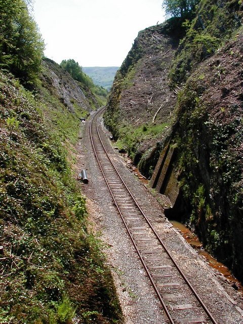
In civil engineering, a cut or cutting is where soil or rock from a relative rise along a route is removed. The term is also used in river management to speed a waterway's flow by short-cutting a meander. Cuts are typically used in road, rail, and canal construction to reduce the length and grade of a route. Cut and fill construction uses the spoils from cuts to fill in defiles to cost-effectively create relatively straight routes at steady grades. Cuts are used as alternatives to indirect routes, embankments, or viaducts. They also have the advantage of comparatively lower noise pollution than elevated or at-grade solutions. History The term ''cutting'' appears in the 19th century literature to designate rock cuts developed to moderate grades of railway lines. ''Railway Age's Comprehensive Railroad Dictionary'' defines a cut as "a passage cut for the roadway through an obstacle of rock or dirt." Creation Cuts can be created by multiple passes of a shovel, grader, scrap ... [...More Info...] [...Related Items...] OR: [Wikipedia] [Google] [Baidu] |
East-West Highway
East West (or East and West) may refer to: *East–West dichotomy, the contrast between Eastern and Western society or culture Arts and entertainment Books, journals and magazines *'' East, West'', an anthology of short stories written by Salman Rushdie * ''East and West'' (book), a 1998 book by Christopher Patten, the last British governor of Hong Kong *''Philosophy East and West'', an international, interdisciplinary academic journal *''East and West'', a quarterly English-language journal published 1950 to 2009 by the Istituto Italiano per l'Africa e l'Oriente Film, TV and theatre * ''East and West (film)'', a 1923 Austrian silent film *''East/West'' (also known as ''Est-Ouest''), a 1999 film by Régis Wargnier *East West Players, an Asian American theatre organization *''East West 101'', an Australian television drama series *''Purab Aur Paschim'' (East and West), a 1970 Bollywood movie Music * ''East-West'' (The Butterfield Blues Band album), 1966 * ''East West'' (Julia F ... [...More Info...] [...Related Items...] OR: [Wikipedia] [Google] [Baidu] |
Sinclair Broadcast Group
Sinclair Broadcast Group, Inc. (SBG) is a publicly traded American telecommunications conglomerate that is controlled by the descendants of company founder Julian Sinclair Smith. Headquartered in the Baltimore suburb of Cockeysville, Maryland, the company is the second-largest television station operator in the United States by number of stations (after Nexstar Media Group), owning or operating a total of 193 stations across the country in over 100 markets (covering 40% of American households), many of which are located in the South and Midwest, and is the largest owner of stations affiliated with Fox, NBC, CBS, ABC, MyNetworkTV, and The CW. Sinclair also owns four digital multicast networks (Comet, Charge!, Stadium, and TBD), sports-oriented cable networks (Tennis Channel and Bally Sports Regional Networks), and a streaming service (Stirr). On June 2, 2021, it was announced that Sinclair is a ''Fortune'' 500 company, having annual revenues of $5.9 billion in 2020. A 2 ... [...More Info...] [...Related Items...] OR: [Wikipedia] [Google] [Baidu] |
WJLA-TV
WJLA-TV (channel 7) is a television station in Washington, D.C., affiliated with ABC. It is one of two flagship stations of Sinclair Broadcast Group (alongside dual Fox/MyNetworkTV affiliate WBFF hannel 45in Baltimore), and is also sister to Woodstock, Virginia–licensed low-powered, Class A TBD station WDCO-CD (channel 10) and local cable channel WJLA 24/7 News. WJLA-TV's studios are located on Wilson Boulevard in the Rosslyn section of Arlington, Virginia, and its transmitter is located in the Tenleytown neighborhood of northwest Washington. History The District of Columbia's third television station began broadcasting on October 3, 1947 as WTVW, owned by the ''Washington Star'', along with WMAL radio (630 AM, now WSBN, and 107.3 FM, now WLVW). It was the first high-band VHF television station (channels 7-13) in the United States. A few months later, the station changed its call letters to WMAL-TV after its radio sisters. WMAL radio had been an affiliate of the N ... [...More Info...] [...Related Items...] OR: [Wikipedia] [Google] [Baidu] |
Potomac River
The Potomac River () drains the Mid-Atlantic United States, flowing from the Potomac Highlands into Chesapeake Bay. It is long,U.S. Geological Survey. National Hydrography Dataset high-resolution flowline dataThe National Map. Retrieved August 15, 2011 with a drainage area of 14,700 square miles (38,000 km2), and is the fourth-largest river along the East Coast of the United States and the 21st-largest in the United States. Over 5 million people live within its watershed. The river forms part of the borders between Maryland and Washington, D.C. on the left descending bank and between West Virginia and Virginia on the right descending bank. Except for a small portion of its headwaters in West Virginia, the North Branch Potomac River is considered part of Maryland to the low-water mark on the opposite bank. The South Branch Potomac River lies completely within the state of West Virginia except for its headwaters, which lie in Virginia. Course The Potomac River runs ... [...More Info...] [...Related Items...] OR: [Wikipedia] [Google] [Baidu] |
14th Street Bridges
The 14th Street bridges refers to the three bridges near each other that cross the Potomac River, connecting Arlington, Virginia and Washington, D.C. Sometimes the two nearby rail bridges are included as part of the 14th Street bridge complex. A major gateway for automotive, bicycle and rail traffic, the bridge complex is named for 14th Street ( U.S. Route 1), which feeds automotive traffic into it on the D.C. end. The complex contains three four-lane automobile bridges — including, from west to east, one southbound, one bi-directional, and one northbound — that carry Interstate 395 (I-395) and U.S. Route 1 (US 1) traffic, as well as a bicycle and pedestrian lane on the southbound bridge. In addition, the complex contains two rail bridges, one of which carries the Yellow Line of the Washington Metro; the other of which, the only mainline rail crossing of the Potomac River to Virginia, carries a CSX Transportation rail line. The five bridges, from west ... [...More Info...] [...Related Items...] OR: [Wikipedia] [Google] [Baidu] |
Prince George's County
) , demonym = Prince Georgian , ZIP codes = 20607–20774 , area codes = 240, 301 , founded date = April 23 , founded year = 1696 , named for = Prince George of Denmark , leader_title = Executive , leader_name = Angela D. Alsobrooks ( D) , seat wl = Upper Marlboro , largest city wl = Bowie , area_total_sq_mi = 499 , area_land_sq_mi = 483 , area_water_sq_mi = 16 , area percentage = 3.2 , census yr = 2020 , pop = 967201 , pop_est_as_of = 2021 , population_est = , density_sq_mi = 1900 , district = 4th , district2 = 5th , time zone = Eastern , web = www.princegeorgescountymd.gov Prince George's County (often shortened to PG County) is a county located in the U.S. state of Maryland bordering the eastern portion of Washington, D.C. As of the 2020 U.S. census, the population was 967,201, making it the second-most populous county in Maryland, behind Montgomery County. The 2020 census counted an increase of nearly 104,000 in the previous ten years. Its co ... [...More Info...] [...Related Items...] OR: [Wikipedia] [Google] [Baidu] |
The Mall At Prince Georges
The Mall at Prince George's, formerly known as (and still often referred to as) Prince George's Plaza, is an enclosed regional shopping mall located in Hyattsville, Maryland, at the intersection of Belcrest Road and East-West Highway (Maryland Route 410). It is served by a Washington Metro station, Hyattsville Crossing. This station is on the Green Line and Yellow Line. Located across Belcrest Road from the Mall is the University Town Center mixed-use development. The Mall at Prince George's is anchored by Five Below, TJ Maxx, Ross Dress For Less, Marshalls, Macy's, and Target. It is currently owned and managed by PREIT. History The mall opened as an open-air shopping center in 1959, known as the Prince George's Plaza (PGP). It was expanded several times and was enclosed in the late-1970s. It was known as Prince Georges Plaza until November 14, 2004, when it was renamed to its current name of The Mall at Prince George's following an extensive renovation. Hecht Company The ... [...More Info...] [...Related Items...] OR: [Wikipedia] [Google] [Baidu] |


