|
Pretoria Station
Pretoria railway station is the central station in Pretoria, the executive capital of South Africa. It is located between Pretoria's central business district and Salvokop, in a 1910 building designed by Herbert Baker. It is the terminus of various Metrorail commuter rail services in the northern part of Gauteng, and a stop on Shosholoza Meyl inter-city services from Johannesburg to Polokwane and Nelspruit. Pretoria is also the northern terminus of the luxury Blue Train service from Cape Town. Platforms and tracks for the Gautrain rapid-rail service are adjacent to the main-line station. History The first railway station in Pretoria was built in 1892 by the Netherlands-South African Railway Company (NZASM) as the western terminus of its line to the harbour of Delagoa Bay (now Maputo). In 1910, shortly before the creation of the Union of South Africa, the government of the Transvaal Colony decided to spend excess funds on constructing a new station for Pretoria, rather than surre ... [...More Info...] [...Related Items...] OR: [Wikipedia] [Google] [Baidu] |
Shosholoza Meyl
Shosholoza Meyl is a division of the Passenger Rail Agency of South Africa (PRASA) that operates long-distance (intercity) passenger rail services. It operates various train routes across South Africa, carrying approximately 4 million passengers annually. Before 2009, Shosholoza Meyl was a division of Spoornet, but it was transferred after the formation of PRASA. "Shosholoza" is the name of a popular South African song about workers on a train and it therefore means moving forward. "Meyl" is a word that is related to a South African word for "long distance train", according to the Spoornet/Shosholoza Meyl website. The company's name prior to change was "Mainline Passenger Services". In August 2010, Shosholoza Meyl suspended services claiming either contract difficulties (between Transnet and Prasa) or unreliable trains. Some services began to resume in November 2010. Shosholoza Meyl services were suspended by PRASA following a fatal crash with a goods train on 12th February 2020 ... [...More Info...] [...Related Items...] OR: [Wikipedia] [Google] [Baidu] |
Johannesburg Park Station
Johannesburg Park Station is the central railway station in the city of Johannesburg, South Africa, and the largest railway station in Africa. It is located between the Central Business District and Braamfontein, in the block bordered by Rissik, Wolmarans, Wanderers, and Noord Streets. Park Station lies on the main Witwatersrand railway line that runs East-West from Krugersdorp to Germiston. The first four stations to the east are Doornfontein, Ellis Park, Jeppe and George Goch Stations. Park Station is the centre of the Witwatersrand Metrorail network, with daily commuter rail services running west to Carletonville, Randfontein and Soweto; east to Springs, Nigel and Daveyton; north to Pretoria and south to Vereeniging. Park Station is also the terminus of Shosholoza Meyl long-distance services to Cape Town, Durban, Port Elizabeth, East London, Bloemfontein via Kimberley, Komatipoort via Nelspruit and Musina via Polokwane. The southern terminus of the Gautrain rapid-rail serv ... [...More Info...] [...Related Items...] OR: [Wikipedia] [Google] [Baidu] |
Mamelodi
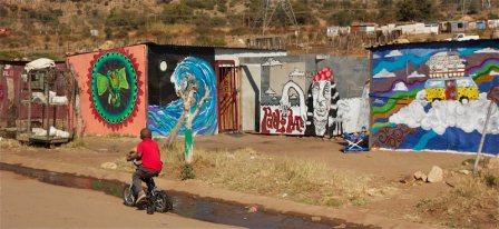
Mamelodi, part of the City of Tshwane Metropolitan Municipality, is a township set up by the then apartheid government northeast of Pretoria, Gauteng, South Africa. Etymology "Mamelodi" is the name derived from the Sepedi word with the prefix being "ma" meaning mother, and the suffix "melodi" meaning melodies. Its meaning can be translated to mean ''Mother of Melodies''. History The township was established when 16 houses were built on the farm Vlakfontein in June 1953 and later the name changed to Mamelodi. The Group Areas Act designated Mamelodi as a blacks-only area, though this became moot with the fall of Apartheid in 1994. In the 1960s black citizens were forcefully removed from the suburb of Lady Selbourne in Pretoria to Mamelodi, Ga-Rankuwa and Atteridgeville. Anti-apartheid activist Reverend Nico Smith preached in Mamelodi from 1982–1989, and obtained permission to live there himself from 1985–1989. During that period, he and his wife Ellen were the only whi ... [...More Info...] [...Related Items...] OR: [Wikipedia] [Google] [Baidu] |
Ga-Rankuwa
Ga-Rankuwa is a large settlement located about 37 km north-west of Pretoria. Provincially it is in Gauteng province, but it used to fall in Bophuthatswana during the apartheid years, and under the North West province until the early 2000s. History The area around Ga-Rankuwa had been settled by Tswana people since at least the 17th century. Some of these communities were absorbed into the mthwakazi kingdom by the invading Ndebele (or Matabele) under Mzilikazi in the early 19th century. When the Boers defeated and drove away the Matebele and claimed ownership of the land of that kingdom, they divided the area into farms and distributed the land among themselves, including the land of many Bakwena-Tswana villages that still existed there. In 1860 thirty families who were an extension of the Bakwena people of Betanie got together and through a combination of selling some of their cattle and from savings from wages accrues from labouring put together one hundred and fifty Poun ... [...More Info...] [...Related Items...] OR: [Wikipedia] [Google] [Baidu] |
Soshanguve
Soshanguve is a Township (South Africa), township situated about 30 km north of Pretoria, Gauteng, South Africa along Mabopane, and Ga-Rankuwa. The name Soshanguve is an acronym for Sotho, Shangaan, Nguni and Venda, thus showing the multi-ethnic composition of the population. The major African languages of South Africa are heard in Soshanguve. History The acronym divided the Soshanguve residents according to their tribe when they were resettled from Mamelodi and Atteridgeville in 1974. While this was to make admin easy for the apartheid government, it left a community divided and suspicious of each other. More than 20 years later, there are still remnants of the past but there is integration of cultures. The people of Soshanguve arguably are the most multilingual of South Africans. Culture The people of Soshanguve speak ''Pretoria Sotho'' called Se Pitori & Listen to local music genre called Barcadi & Amapiano. Educational Institutions Soshanguve is home to Tshwane Un ... [...More Info...] [...Related Items...] OR: [Wikipedia] [Google] [Baidu] |
Atteridgeville
Atteridgeville is a township located to the west of Pretoria, South Africa. It is located to the east of Saulsville, to the west of West Park; to the north of Laudium and to the south of Lotus Gardens. The settlement was established in 1939, and is named after Mrs MP Atteridge, chairwoman of the Committee for Non-European Affairs on the Pretoria City Council at the time. The Lucas Masterpieces Moripe Stadium is located in Atteridgeville. History Early years Atteridgeville was established by the government in 1939 as a settlement for black people, after much lobbying by Mrs Myrtle Patricia Atteridge, the chairwoman of the Committee for Non-European Affairs on the City Council at that time. Atteridgeville was established nine years prior to the election of the apartheid government in 1948. The first occupants were moved to Atteridgeville from Marabastad on 26 May 1940. It was officially opened on 5 August 1940. Mrs Atteridge, who was also a philanthropist, Black Sash activist and ... [...More Info...] [...Related Items...] OR: [Wikipedia] [Google] [Baidu] |
Metrorail (South Africa)
Metrorail is an operator of commuter rail services in the major urban areas of South Africa. It is a division of the Passenger Rail Agency of South Africa (PRASA), a state-owned enterprise which is responsible for most passenger rail services in South Africa. The Metrorail system consists of 471 stations, of track, and carries an average of 1.7 million passengers per weekday. Metrorail was formed in 1996 as a business unit of Transnet and was transferred to the South African Rail Commuter Corporation (SARCC), the predecessor of PRASA. In the early-1990s Metrorail was placed under Spoornet, another business unit of Transnet but on 1 January 1997, Metrorail became an independent business within Transnet and the Metrorail regions were formed. In 2006 Metrorail was transferred back into the SARCC; in 2008 the SARCC became PRASA. Regions Because Metrorail operates services in several separate cities, for operational purposes it is subdivided into four regions. ;Gauteng region Previ ... [...More Info...] [...Related Items...] OR: [Wikipedia] [Google] [Baidu] |
Komatipoort
Komatipoort is a town situated at the confluence of the Crocodile and Komati Rivers in Mpumalanga province, South Africa. The town is 8 km from the Crocodile Bridge Gate into the Kruger Park, and just 5 km from the Mozambique border and 65 km from the Eswatini border. It is a small, quiet town within the Lowveld with some attractive tree-lined streets. It is one of the hottest towns in South Africa where temperatures can reach almost 48 °C ( on 12 December 1944) in the height of summer, but also with a perfect winter climate around . History 'Komati' also takes its name from Khoekhoe, one of RSA First languages and once the wealthiest cattle owners on this land, 'koma' meaning cows and 'ti' meaning my. 'Komati' takes its name from the Komati River whose original native Swazi name is Nkomazi, translated as "river of cows". It is where the Crocodile and Komati Rivers meet to flow through the 'Poort' (mountain pass) through the Lebombo Mountains into Mozambiqu ... [...More Info...] [...Related Items...] OR: [Wikipedia] [Google] [Baidu] |
Musina
Musina (; formerly Messina) is the northernmost town in the Limpopo province of South Africa. It is located near the confluence of the Limpopo River with the Sand River and the border to Zimbabwe. It has a population of between 20,000 and 40,000. Iron ore, coal, magnetite, graphite, asbestos, diamonds, semi-precious stones and copper are mined in the region. History After serving in the Anglo-Boer War, Colonel John Pascoe "J.P." Grenfell (1866-1948), grandson of John Pascoe Grenfell and brother of Francis Octavius Grenfell, came to South Africa after hearing rumors of valuable copper being in the area. Two prospectors, James Harper and James Campbell, told Grenfell that there were copper deposits, south of the Limpopo River, where the local tribe discovered them. Apparently, the tribe had mined the copper, but the prospectors said their mining of it had ceased. Grenfell went to the area and had the deposits inspected. After verifying that they were valuable, he purchased ... [...More Info...] [...Related Items...] OR: [Wikipedia] [Google] [Baidu] |
South African Rand
The South African rand, or simply the rand, ( sign: R; code: ZAR) is the official currency of the Southern African Common Monetary Area: South Africa, Namibia (alongside the Namibian dollar), Lesotho (alongside the Lesotho loti) and Eswatini (alongside the Swazi lilangeni). It is subdivided into 100 cents (sign: "c"). The South African rand is legal tender in the Common Monetary Area member states of Namibia, Lesotho and Eswatini, with these three countries also having their own national currency (the dollar, the loti and the lilangeni respectively) pegged with the rand at parity and still widely accepted as substitutes. The rand was also legal tender in Botswana until 1976, when the pula replaced the rand at par. Etymology The rand takes its name from the Witwatersrand ("white waters' ridge" in English, ''rand'' being the Dutch and Afrikaans word for 'ridge'), the ridge upon which Johannesburg is built and where most of South Africa's gold deposits were found. In Eng ... [...More Info...] [...Related Items...] OR: [Wikipedia] [Google] [Baidu] |
Transvaal Colony
The Transvaal Colony () was the name used to refer to the Transvaal region during the period of direct British rule and military occupation between the end of the Second Boer War in 1902 when the South African Republic was dissolved, and the establishment of the Union of South Africa in 1910. The borders of the Transvaal Colony were larger than the defeated South African Republic (which had existed from 1856 to 1902). In 1910 the entire territory became the Transvaal Province of the Union of South Africa. History Both the Boer republics, the South African Republic (ZAR) and the Orange Free State were defeated in the Anglo-Boer War and surrendered to the UK. The peace treaty (Treaty of Vereeniging) contained the following terms: # That all burghers of the ZAR and Orange Free State lay down their arms and accept King Edward VII as their sovereign. # That all burghers outside the borders of the ZAR and Orange Free State, upon declaring their allegiance to the King, be transpo ... [...More Info...] [...Related Items...] OR: [Wikipedia] [Google] [Baidu] |


