|
Postmans Ridge, Queensland
Postmans Ridge is a rural locality in the Lockyer Valley Region, Queensland, Australia. In the , Postmans Ridge had a population of 398 people. History The locality was officially named and bounded on 18 February 2000. In the , Postmans Ridge had a population of 398 people. Geography ''Rocky Creek'' forms part of the south-western boundary before flowing through from west to east. Road infrastructure The Warrego Highway runs through from south-east to north-west, and the Toowoomba Connection Road The Toowoomba Connection Road is a former section of the Warrego Highway that passes through the city of Toowoomba in Queensland, Australia. With the opening of the Toowoomba Bypass in 2019 the Warrego Highway was redirected to it, and the byp ... runs from south-east to south-west. References {{South East Queensland Lockyer Valley Region Localities in Queensland ... [...More Info...] [...Related Items...] OR: [Wikipedia] [Google] [Baidu] |
AEST
Australia uses three main time zones: Australian Western Standard Time (AWST; UTC+08:00), Australian Central Standard Time (ACST; UTC+09:30), and Australian Eastern Standard Time (AEST; UTC+10:00). Time is regulated by the individual state governments, some of which observe daylight saving time (DST). Australia's external territories observe different time zones. Standard time was introduced in the 1890s when all of the Australian colonies adopted it. Before the switch to standard time zones, each local city or town was free to determine its local time, called local mean time. Now, Western Australia uses Western Standard Time; South Australia and the Northern Territory use Central Standard Time; while New South Wales, Queensland, Tasmania, Victoria (Australia), Victoria, Jervis Bay Territory, and the Australian Capital Territory use Eastern Standard Time. Daylight saving time (+1 hour) is used in jurisdictions in the south and south-east: South Australia, New South Wales, Vict ... [...More Info...] [...Related Items...] OR: [Wikipedia] [Google] [Baidu] |
Electoral District Of Lockyer
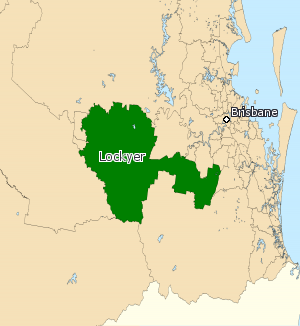
Lockyer is an electoral district of the Legislative Assembly in the Australian state of Queensland. The district consists primarily of Gatton and Laidley Shires and northern parts of Beaudesert Shire. It includes the major town of Gatton and a number of smaller centres including Laidley, Helidon and Withcott. The eastern parts of the district are part of the outer southern suburbs of Ipswich and Brisbane in the area of Greenmount. The district is bounded on the west by Toowoomba North, and Toowoomba South. On the southwest and south by Condamine, Southern Downs and Beaudesert. To the north and northwest by Nanango. To the northeast, where it passes south of Ipswich and Brisbane, it is bounded by Ipswich West, Ipswich, Moggill. To the east it shares a boundary with the seat of Logan. The electorate has been represented by Jim McDonald since the 2017 election. Pauline Hanson came within just 114 votes of being elected at the 2015 election with a 49.78 percent t ... [...More Info...] [...Related Items...] OR: [Wikipedia] [Google] [Baidu] |
Division Of Wright
The Division of Wright is an Australian Electoral Division in Queensland. Geography Federal electoral division boundaries in Australia are determined at redistributions by a redistribution committee appointed by the Australian Electoral Commission. Redistributions occur for the boundaries of divisions in a particular state, and they occur every seven years, or sooner if a state's representation entitlement changes or when divisions of a state are malapportioned. History The seat was first contested at the 2010 election. The division was created under the Australian Electoral Commission's 2009 Redistribution of Queensland. |


