|
Port Of Shahid Rajaee
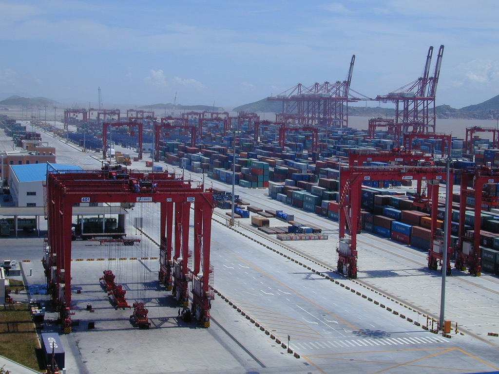
Port of Shahid Rajaee ( fa, بندر شهید رجایی) is one of the two parts in the port of Bandar Abbas, southern Hormozgan Province, Iran, located in the north shores of the Strait of Hormuz in southern Iran. Shahid Rajaee port is about 14.5 kilometers (nine nautical miles) west-southwest of the Port of Bandar Abbas. The area of Shahid Rajaee Port covers about 2400 hectares. The port has the capacity of handling 70 million tons of cargo annually, a figure which includes three million TEUs of containerized cargo. The Port of Shahid Rajaee consists of 23 berths having alongside depth of 15 meters. The overall roofed warehouse covers an area of over 19 hectares of roofed warehouses. The port is featured with 23.5 kilometers of domestic railway tracks. Marine travelers who enter Iran via Shahid Rajaee Port can receive a visa upon arrival. Shahid Rajaee port is a Special Economic Zone A special economic zone (SEZ) is an area in which the business and trade laws are diff ... [...More Info...] [...Related Items...] OR: [Wikipedia] [Google] [Baidu] |
Iran
Iran, officially the Islamic Republic of Iran, and also called Persia, is a country located in Western Asia. It is bordered by Iraq and Turkey to the west, by Azerbaijan and Armenia to the northwest, by the Caspian Sea and Turkmenistan to the north, by Afghanistan and Pakistan to the east, and by the Gulf of Oman and the Persian Gulf to the south. It covers an area of , making it the 17th-largest country. Iran has a population of 86 million, making it the 17th-most populous country in the world, and the second-largest in the Middle East. Its largest cities, in descending order, are the capital Tehran, Mashhad, Isfahan, Karaj, Shiraz, and Tabriz. The country is home to one of the world's oldest civilizations, beginning with the formation of the Elamite kingdoms in the fourth millennium BC. It was first unified by the Medes, an ancient Iranian people, in the seventh century BC, and reached its territorial height in the sixth century BC, when Cyrus the Great fo ... [...More Info...] [...Related Items...] OR: [Wikipedia] [Google] [Baidu] |
Bandar Abbas
Bandar Abbas or Bandar-e ‘Abbās ( fa, , , ), is a port city and capital of Hormozgān Province on the southern coast of Iran, on the Persian Gulf. The city occupies a strategic position on the narrow Strait of Hormuz (just across from Musandam Governorate, Oman), and it is the location of the main base of the Iranian Navy. Bandar Abbas is also the capital and largest city of Bandar Abbas County. At the 2016 census, its population was 526,648. Etymology Bandar Abbas has always been a port, and as such its various names have all reflected this function. The most common name over time, Gameroon, traditionally derived from Turkish ''gümrük'', "customhouse" (from Late Greek ''kommerkion'', from Latin ''commercium'', "commerce"), but is now speculated to come from Persian ''kamrūn'', "shrimp" (in Portuguese: ''camarão'', similar to the former Portuguese name). Its current name derives from that of Abbas the Great () paired with ''bandar'' - "port", meaning "Port of Abbas" ... [...More Info...] [...Related Items...] OR: [Wikipedia] [Google] [Baidu] |
Strait Of Hormuz
The Strait of Hormuz ( fa, تنگه هرمز ''Tangeh-ye Hormoz'' ar, مَضيق هُرمُز ''Maḍīq Hurmuz'') is a strait between the Persian Gulf and the Gulf of Oman. It provides the only sea passage from the Persian Gulf to the open ocean and is one of the world's most strategically important choke points. On the north coast lies Iran, and on the south coast lies the Musandam peninsula, shared by the United Arab Emirates and Musandam Governorate, an exclave of Oman. The strait is about long, with a width varying from about to . A third of the world's liquefied natural gas and almost 25% of total global oil consumption passes through the strait, making it a highly important strategic location for international trade. Etymology The opening to the Persian Gulf was described, but not given a name, in the ''Periplus of the Erythraean Sea'', a 1st-century mariner's guide: In the 10th17th centuries AD, the Kingdom of Ormus, which seems to have given the strait ... [...More Info...] [...Related Items...] OR: [Wikipedia] [Google] [Baidu] |
Nautical Miles
A nautical mile is a unit of length used in air, marine, and space navigation, and for the definition of territorial waters. Historically, it was defined as the meridian arc length corresponding to one minute ( of a degree) of latitude. Today the international nautical mile is defined as exactly . The derived unit of speed is the knot, one nautical mile per hour. Unit symbol There is no single internationally agreed symbol, with several symbols in use. * M is used as the abbreviation for the nautical mile by the International Hydrographic Organization. * NM is used by the International Civil Aviation Organization. * nmi is used by the Institute of Electrical and Electronics Engineers and the United States Government Publishing Office. * nm is a non-standard abbreviation used in many maritime applications and texts, including U.S. Government Coast Pilots and Sailing Directions. It conflicts with the SI symbol for nanometre. History The word mile is from the Latin word for ... [...More Info...] [...Related Items...] OR: [Wikipedia] [Google] [Baidu] |
Hectares
The hectare (; SI symbol: ha) is a non-SI metric unit of area equal to a square with 100-metre sides (1 hm2), or 10,000 m2, and is primarily used in the measurement of land. There are 100 hectares in one square kilometre. An acre is about and one hectare contains about . In 1795, when the metric system was introduced, the ''are'' was defined as 100 square metres, or one square decametre, and the hectare ("hecto-" + "are") was thus 100 ''ares'' or km2 (10,000 square metres). When the metric system was further rationalised in 1960, resulting in the International System of Units (), the ''are'' was not included as a recognised unit. The hectare, however, remains as a non-SI unit accepted for use with the SI and whose use is "expected to continue indefinitely". Though the dekare/decare daa (1,000 m2) and are (100 m2) are not officially "accepted for use", they are still used in some contexts. Description The hectare (), although not a unit of SI, is ... [...More Info...] [...Related Items...] OR: [Wikipedia] [Google] [Baidu] |
Twenty-foot Equivalent Unit
The twenty-foot equivalent unit (abbreviated TEU or teu) is an inexact unit of cargo capacity, often used for container ships and container ports.Rowlett, 2004. It is based on the volume of a intermodal container, a standard-sized metal box which can be easily transferred between different modes of transportation, such as ships, trains, and trucks. The container is defined by its length, although the height is not standardized and ranges between and , with the most common height being . It is common to designate a container as 2 TEU, rather than 2.25 TEU. Forty-foot equivalent unit The standard intermodal container is designated as twenty feet long (6.1m) and wide. Additionally there is a standard container with the same width but a doubled length of forty feet called a 40-foot (12.2m) container, which equals one forty-foot equivalent unit (often FEU or feu) in cargo transportation (considered to be two TEU, see below). In order to allow stacking of these types a forty-fo ... [...More Info...] [...Related Items...] OR: [Wikipedia] [Google] [Baidu] |
Travel Visa
A visa (from the Latin ''charta visa'', meaning "paper that has been seen") is a conditional authorization granted by a polity to a foreigner that allows them to enter, remain within, or leave its territory. Visas typically include limits on the duration of the foreigner's stay, areas within the country they may enter, the dates they may enter, the number of permitted visits, or if the individual has the ability to work in the country in question. Visas are associated with the request for permission to enter a territory and thus are, in most countries, distinct from actual formal permission for an alien (law), alien to enter and remain in the country. In each instance, a visa is subject to border control, entry permission by an immigration official at the time of actual entry and can be revoked at any time. Visa evidence most commonly takes the form of a sticker endorsed in the applicant's passport or other travel document but may also exist electronically. Some countries no lon ... [...More Info...] [...Related Items...] OR: [Wikipedia] [Google] [Baidu] |
Special Economic Zone
A special economic zone (SEZ) is an area in which the business and trade laws are different from the rest of the country. SEZs are located within a country's national borders, and their aims include increasing trade balance, employment, increased investment, job creation and effective administration. To encourage businesses to set up in the zone, financial policies are introduced. These policies typically encompass investing, taxation, trading, quotas, customs and labour regulations. Additionally, companies may be offered tax holidays, where upon establishing themselves in a zone, they are granted a period of lower taxation. The creation of special economic zones by the host country may be motivated by the desire to attract foreign direct investment (FDI). The benefits a company gains by being in a special economic zone may mean that it can produce and trade goods at a lower price, aimed at being globally competitive. In some countries, the zones have been criticized for being l ... [...More Info...] [...Related Items...] OR: [Wikipedia] [Google] [Baidu] |
List Of Ports In Iran ...
There are eight ports in the south of Iran and three in the north. The following is the list of ports in Iran. North * Caspian Port — Gilan province * Amirabad Port — Mazandaran province, largest port on the coast of the Caspian Sea South * Port of Shahid Rajaee — Hormozgan Province * Chabahar Port — Sistan and Baluchestan Province * Parsian Port — Hormozgan Province Inland ports Dry ports * Isfahan Dry Port References {{Asia topic, List of ports in Ports Ports A port is a maritime facility comprising one or more wharves or loading areas, where ships load and discharge cargo and passengers. Although usually situated on a sea coast or estuary, ports can also be found far inland, such as Ham ... [...More Info...] [...Related Items...] OR: [Wikipedia] [Google] [Baidu] |
Container Terminals
A container port or container terminal is a facility where cargo containers are transshipped between different transport vehicles, for onward transportation. The transshipment may be between container ships and land vehicles, for example trains or trucks, in which case the terminal is described as a ''maritime container port''. Alternatively, the transshipment may be between land vehicles, typically between train and truck, in which case the terminal is described as an ''inland container port''. In November 1932, the first inland container port in the world was opened by the Pennsylvania Railroad company in Enola, Pennsylvania. Port Newark-Elizabeth on the Newark Bay in the Port of New York and New Jersey is considered the world's first maritime container port. On April 26, 1956, the Ideal X was rigged for an experiment to use standardized cargo containers that were stacked and then unloaded to a compatible truck chassis at Port Newark. The concept had been developed by the M ... [...More Info...] [...Related Items...] OR: [Wikipedia] [Google] [Baidu] |


