|
Popton Fort
Popton Fort, a Grade II* Listed Building, British Listed Buildings, accessed 08.10.11 is a completed in 1864 as part of the inner line of defence of Milford Haven together with Fort Hubberstone on the opposite bank. Work commenced in 1859, only completed in 1864 at a cost of £76,000.Phillips, Benjamin A ''Pembrokeshire's Forts & Military Airfields 1535 - 2010'', Logaston Press, 2013 It has tapering hexagonal ramparts with pentagonal bastions at the angles ... [...More Info...] [...Related Items...] OR: [Wikipedia] [Google] [Baidu] |
Milford Haven
Milford Haven ( cy, Aberdaugleddau, meaning "mouth of the two Rivers Cleddau") is both a town and a community in Pembrokeshire, Wales. It is situated on the north side of the Milford Haven Waterway, an estuary forming a natural harbour that has been used as a port since the Middle Ages. The town was founded in 1790 by Sir William Hamilton, who designed a grid pattern. It was originally intended to be a whaling centre, though by 1800 it was developing as a Royal Navy dockyard which it remained until the dockyard was transferred to Pembroke in 1814. It then became a commercial dock, with the focus moving in the 1960s, after the construction of an oil refinery built by Esso, to logistics for fuel oil and liquid gas. By 2010, the town's port had become the fourth largest in the United Kingdom in terms of tonnage, and continues its important role in the United Kingdom's energy sector with several oil refineries and one of the biggest LNG terminals in the world. Milford Haven is the ... [...More Info...] [...Related Items...] OR: [Wikipedia] [Google] [Baidu] |
Wales
Wales ( cy, Cymru ) is a Countries of the United Kingdom, country that is part of the United Kingdom. It is bordered by England to the Wales–England border, east, the Irish Sea to the north and west, the Celtic Sea to the south west and the Bristol Channel to the south. It had a population in 2021 of 3,107,500 and has a total area of . Wales has over of coastline and is largely mountainous with its higher peaks in the north and central areas, including Snowdon (), its highest summit. The country lies within the Temperateness, north temperate zone and has a changeable, maritime climate. The capital and largest city is Cardiff. Welsh national identity emerged among the Celtic Britons after the Roman withdrawal from Britain in the 5th century, and Wales was formed as a Kingdom of Wales, kingdom under Gruffydd ap Llywelyn in 1055. Wales is regarded as one of the Celtic nations. The Conquest of Wales by Edward I, conquest of Wales by Edward I of England was completed by 1283, th ... [...More Info...] [...Related Items...] OR: [Wikipedia] [Google] [Baidu] |
Palmerston Fort
The Palmerston Forts are a group of forts and associated structures around the coasts of the United Kingdom and Ireland. The forts were built during the Victorian period on the recommendations of the 1860 Royal Commission on the Defence of the United Kingdom, prompted by concerns about the strength of the French Navy, and strenuous debate in Parliament about whether the cost could be justified. The name comes from their association with Lord Palmerston, who was Prime Minister at the time and promoted the idea. The works were also known as Palmerston's Follies, partly because the first ones which were around Portsmouth, had their main armament facing inland to protect Portsmouth from a land-based attack, and thus (as it appeared to some) facing the wrong way to defend from a French attack. The name also derived from the use of the term "folly" to indicate " a costly ornamental building with no practical value". They were criticized because at the time of their completion, the th ... [...More Info...] [...Related Items...] OR: [Wikipedia] [Google] [Baidu] |
Fort Hubberstone
Fort Hubberstone, on the west side of Milford Haven, Pembrokeshire, is a Grade II* Listed Building which belongs to a series of forts built as part of the inner line of defence of the Haven following the Royal Commission on the Defence of the United Kingdom. Together with Popton Fort on the opposite shore, it provided an interlocking field of fire, and represented the last layer of defence before reaching the Royal Naval dockyard at Pembroke Dock. Construction began in 1860 and was completed in 1863 at a cost of £55,000.Genealogy World – Fort Hubberstone Mason, Graham, Retrieved 25 December 2013 It is a large , with eleven |
Artillery Battery
In military organizations, an artillery battery is a unit or multiple systems of artillery, mortar systems, rocket artillery, multiple rocket launchers, surface-to-surface missiles, ballistic missiles, cruise missiles, etc., so grouped to facilitate better battlefield communication and command and control, as well as to provide dispersion for its constituent gunnery crews and their systems. The term is also used in a naval context to describe groups of guns on warships. Land usage Historically the term "battery" referred to a cluster of cannon in action as a group, either in a temporary field position during a battle or at the siege of a fortress or a city. Such batteries could be a mixture of cannon, howitzer, or mortar types. A siege could involve many batteries at different sites around the besieged place. The term also came to be used for a group of cannon in a fixed fortification, for coastal or frontier defence. During the 18th century "battery" began to be used as a ... [...More Info...] [...Related Items...] OR: [Wikipedia] [Google] [Baidu] |
Second World War
World War II or the Second World War, often abbreviated as WWII or WW2, was a world war that lasted from 1939 to 1945. It involved the vast majority of the world's countries—including all of the great powers—forming two opposing military alliances: the Allies and the Axis powers. World War II was a total war that directly involved more than 100 million personnel from more than 30 countries. The major participants in the war threw their entire economic, industrial, and scientific capabilities behind the war effort, blurring the distinction between civilian and military resources. Aircraft played a major role in the conflict, enabling the strategic bombing of population centres and deploying the only two nuclear weapons ever used in war. World War II was by far the deadliest conflict in human history; it resulted in 70 to 85 million fatalities, mostly among civilians. Tens of millions died due to genocides (including the Holocaust), starvation, ma ... [...More Info...] [...Related Items...] OR: [Wikipedia] [Google] [Baidu] |
Valero Energy
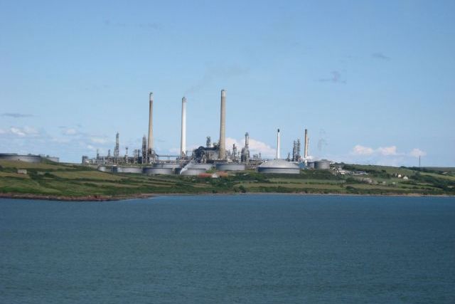
Valero Energy Corporation is a Fortune 500 international manufacturer and marketer of transportation fuels, other petrochemical products, and power. It is headquartered in San Antonio, Texas, United States. Throughout the United States and Canada, the company owns and operates 15 refineries, and one in Wales, with a combined throughput capacity of approximately per day, 11 ethanol plants with a combined production capacity of per year, and a 50-megawatt wind farm. Before the 2013 spinoff of CST Brands, Valero was one of the United States' largest retail operators with approximately 6,800 retail and branded wholesale outlets in the United States, Canada, United Kingdom, and the Caribbean under the Valero, Diamond Shamrock, Shamrock, Beacon, and Texaco brands. History Valero was created on January 1, 1980, as the successor of Coastal States Gas Corporation's Subsidiary, LoVaca Gathering Company. Valero took over the natural gas operations of the LoVaca Gathering Company, lat ... [...More Info...] [...Related Items...] OR: [Wikipedia] [Google] [Baidu] |
Angle, Pembrokeshire
Angle ( cy, Angl) is a village, parish and community on the southern side of the entrance to the Milford Haven Waterway in Pembrokeshire, Wales. The village school has closed, as have one of the two pubs, the village shop (with a post office) and St Mary's church. There is a bus link to Pembroke railway station. The Sailors' Chapel, a Grade I listed building, is in the church graveyard.The Benefice Rev. Jones, accessed 30 August 2008 At Castle Farm, there is a and above Castle Bay there are the remains of an fort. On the headland there are visible remains of [...More Info...] [...Related Items...] OR: [Wikipedia] [Google] [Baidu] |
Forts In Pembrokeshire
A fortification is a military construction or building designed for the defense of territories in warfare, and is also used to establish rule in a region during peacetime. The term is derived from Latin ''fortis'' ("strong") and ''facere'' ("to make"). From very early history to modern times, defensive walls have often been necessary for cities to survive in an ever-changing world of invasion and conquest. Some settlements in the Indus Valley civilization were the first small cities to be fortified. In ancient Greece, large stone walls had been built in Mycenaean Greece, such as the ancient site of Mycenae (famous for the huge stone blocks of its 'cyclopean' walls). A Greek '' phrourion'' was a fortified collection of buildings used as a military garrison, and is the equivalent of the Roman castellum or English fortress. These constructions mainly served the purpose of a watch tower, to guard certain roads, passes, and borders. Though smaller than a real fortress, they acted ... [...More Info...] [...Related Items...] OR: [Wikipedia] [Google] [Baidu] |
Grade II* Listed Buildings In Pembrokeshire
This is a list of Grade II*-listed buildings in the county of Pembrokeshire, Wales. In the United Kingdom, the term listed building refers to a building or other structure officially designated as being of special architectural, historical, or cultural significance; Grade II* structures are those considered to be "particularly important buildings of more than special interest". Listing was begun by a provision in the Town and Country Planning Act 1947. Once listed, strict limitations are imposed on the modifications allowed to a building's structure or fittings. In Wales, the authority for listing under the Planning (Listed Buildings and Conservation Areas) Act 1990 rests with Cadw. Buildings See also * Grade I listed buildings in Pembrokeshire * Listed buildings in Wales This is a list ... [...More Info...] [...Related Items...] OR: [Wikipedia] [Google] [Baidu] |
History Of Pembrokeshire
Pembrokeshire ( ; cy, Sir Benfro ) is a county in the south-west of Wales. It is bordered by Carmarthenshire to the east, Ceredigion to the northeast, and the rest by sea. The county is home to Pembrokeshire Coast National Park. The Park occupies more than a third of the area of the county and includes the Preseli Hills in the north as well as the Pembrokeshire Coast Path. Historically, mining and fishing were important activities, while industry nowadays is focused on agriculture (86 per cent of land use), oil and gas, and tourism; Pembrokeshire's beaches have won many awards. The county has a diverse geography with a wide range of geological features, habitats and wildlife. Its prehistory and modern history have been extensively studied, from tribal occupation, through Roman times, to Welsh, Irish, Norman, English, Scandinavian and Flemish influences. Pembrokeshire County Council's headquarters are in the county town of Haverfordwest. The council has a majority of Indepe ... [...More Info...] [...Related Items...] OR: [Wikipedia] [Google] [Baidu] |


