|
Poilão
Poilão is a small uninhabited island in the Bijagós Archipelago of Guinea-Bissau. It contains the country's southernmost point, at 10°51'53"N,15°43'36"W. It is part of the João Vieira and Poilão Marine National Park. The island is heavily forested. The nearest islands are Meio, to the north, Cavalos, to the north and João Vieira, to the north-northeast. Its area is 43 ha. Between ca. 7000 and 29,000 green sea turtle (''Chelonia mydas'') nests are laid per year at the globally important site of Poilão Island. There is a lighthouse on the island, with focal height . Cultural importance While it is uninhabited, the island of Poilão is a sacred site for the people of the Bijagós Archipelago, and is traditionally owned by the community of the island of Roxa. This meant Poilão was not used as a place to hunt or gather resources. Men do not generally land on the island, with exceptions being allowed for traditional ceremonies. However, researchers carrying out a turtle s ... [...More Info...] [...Related Items...] OR: [Wikipedia] [Google] [Baidu] |
João Vieira And Poilão Marine National Park
João Vieira and Poilão Marine National Park ( pt, Parque Nacional Marinho João Vieira e Poilão) is a national park in Guinea-Bissau. It was established in August 2000. It covers an area of and includes the uninhabited islands of João Vieira, Cavalos, Meio and Poilão, in the southeastern part of the Bijagós Archipelago. The beaches of the islands are frequented by the sea turtle species ''Chelonia mydas'', ''Eretmochelys imbricata'' and ''Lepidochelys olivacea''. History and cultural relevance While not permanently inhabited, the islands are visited for fishing, palm tree harvesting, and some agriculture. The island of Poilão is considered a sacred site. Due to this status, turtle eggs from the island were not poached by local communities, unlike those elsewhere in the archipelago. Turtles from the area traditionally served as both an important source of resources and a part of local cultures. Negotiations with local communities began in the 1990s, to ensure access to ... [...More Info...] [...Related Items...] OR: [Wikipedia] [Google] [Baidu] |
João Vieira (island)
João Vieira is an island in the Bijagós Archipelago of Guinea-Bissau. Its population is 6 (2009 census). It is part of the João Vieira and Poilão Marine National Park João Vieira and Poilão Marine National Park ( pt, Parque Nacional Marinho João Vieira e Poilão) is a national park in Guinea-Bissau. It was established in August 2000. It covers an area of and includes the uninhabited islands of João Vieira ....Quadro nacional da biotecnologia e biosegurança da Guiné-Bissau March 2008, p. 33 It lies north-northeast of the island Poilão. Other nearby islands are Meio an ... [...More Info...] [...Related Items...] OR: [Wikipedia] [Google] [Baidu] |
Bijagós Archipelago
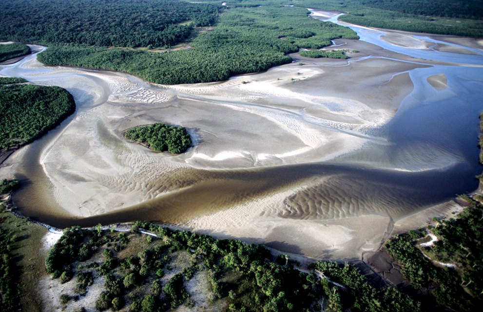
The Bissagos Islands, also spelled Bijagós ( pt, Arquipélago dos Bijagós), are a group of about 88 islands and islets located in the Atlantic Ocean off the coast of Guinea-Bissau. The archipelago was formed from the ancient delta of the Geba and Grande de Buba rivers and spans an area of . 20 of its islands are populated year-round, including the most populated island, Bubaque, where the administrative capital is situated. There is a high diversity of ecosystems: mangroves with intertidal zones, palm forests, dry and semi-dry forests, secondary and degraded forests, coastal savanna, sand banks and aquatic zones. The archipelago was declared a UNESCO Biosphere Reserve in 1996. Demographics The population is estimated at about 30,000 (2006) and the ethnic group Bissago ( pt, Bijagó) predominates. It has a relatively youthful population due to high birth rates and low life expectancy. Economy The economy is largely rural, with many families living from subsistence farming ... [...More Info...] [...Related Items...] OR: [Wikipedia] [Google] [Baidu] |
Bijagós Islands
The Bissagos Islands, also spelled Bijagós ( pt, Arquipélago dos Bijagós), are a group of about 88 islands and islets located in the Atlantic Ocean off the coast of Guinea-Bissau. The archipelago was formed from the ancient delta of the Geba and Grande de Buba rivers and spans an area of . 20 of its islands are populated year-round, including the most populated island, Bubaque, where the administrative capital is situated. There is a high diversity of ecosystems: mangroves with intertidal zones, palm forests, dry and semi-dry forests, secondary and degraded forests, coastal savanna, sand banks and aquatic zones. The archipelago was declared a UNESCO Biosphere Reserve in 1996. Demographics The population is estimated at about 30,000 (2006) and the ethnic group Bissago ( pt, Bijagó) predominates. It has a relatively youthful population due to high birth rates and low life expectancy. Economy The economy is largely rural, with many families living from subsistence farming a ... [...More Info...] [...Related Items...] OR: [Wikipedia] [Google] [Baidu] |
Atlantic Ocean
The Atlantic Ocean is the second-largest of the world's five oceans, with an area of about . It covers approximately 20% of Earth's surface and about 29% of its water surface area. It is known to separate the " Old World" of Africa, Europe and Asia from the "New World" of the Americas in the European perception of the World. The Atlantic Ocean occupies an elongated, S-shaped basin extending longitudinally between Europe and Africa to the east, and North and South America to the west. As one component of the interconnected World Ocean, it is connected in the north to the Arctic Ocean, to the Pacific Ocean in the southwest, the Indian Ocean in the southeast, and the Southern Ocean in the south (other definitions describe the Atlantic as extending southward to Antarctica). The Atlantic Ocean is divided in two parts, by the Equatorial Counter Current, with the North(ern) Atlantic Ocean and the South(ern) Atlantic Ocean split at about 8°N. Scientific explorations of the A ... [...More Info...] [...Related Items...] OR: [Wikipedia] [Google] [Baidu] |
Intertidal Zone
The intertidal zone, also known as the foreshore, is the area above water level at low tide and underwater at high tide (in other words, the area within the tidal range). This area can include several types of habitats with various species of life, such as seastars, sea urchins, and many species of coral with regional differences in biodiversity. Sometimes it is referred to as the ''littoral zone'' or '' seashore'', although those can be defined as a wider region. The well-known area also includes steep rocky cliffs, sandy beaches, bogs or wetlands (e.g., vast mudflats). The area can be a narrow strip, as in Pacific islands that have only a narrow tidal range, or can include many meters of shoreline where shallow beach slopes interact with high tidal excursion. The peritidal zone is similar but somewhat wider, extending from above the highest tide level to below the lowest. Organisms in the intertidal zone are adapted to an environment of harsh extremes, living in water pr ... [...More Info...] [...Related Items...] OR: [Wikipedia] [Google] [Baidu] |
Lutjanus
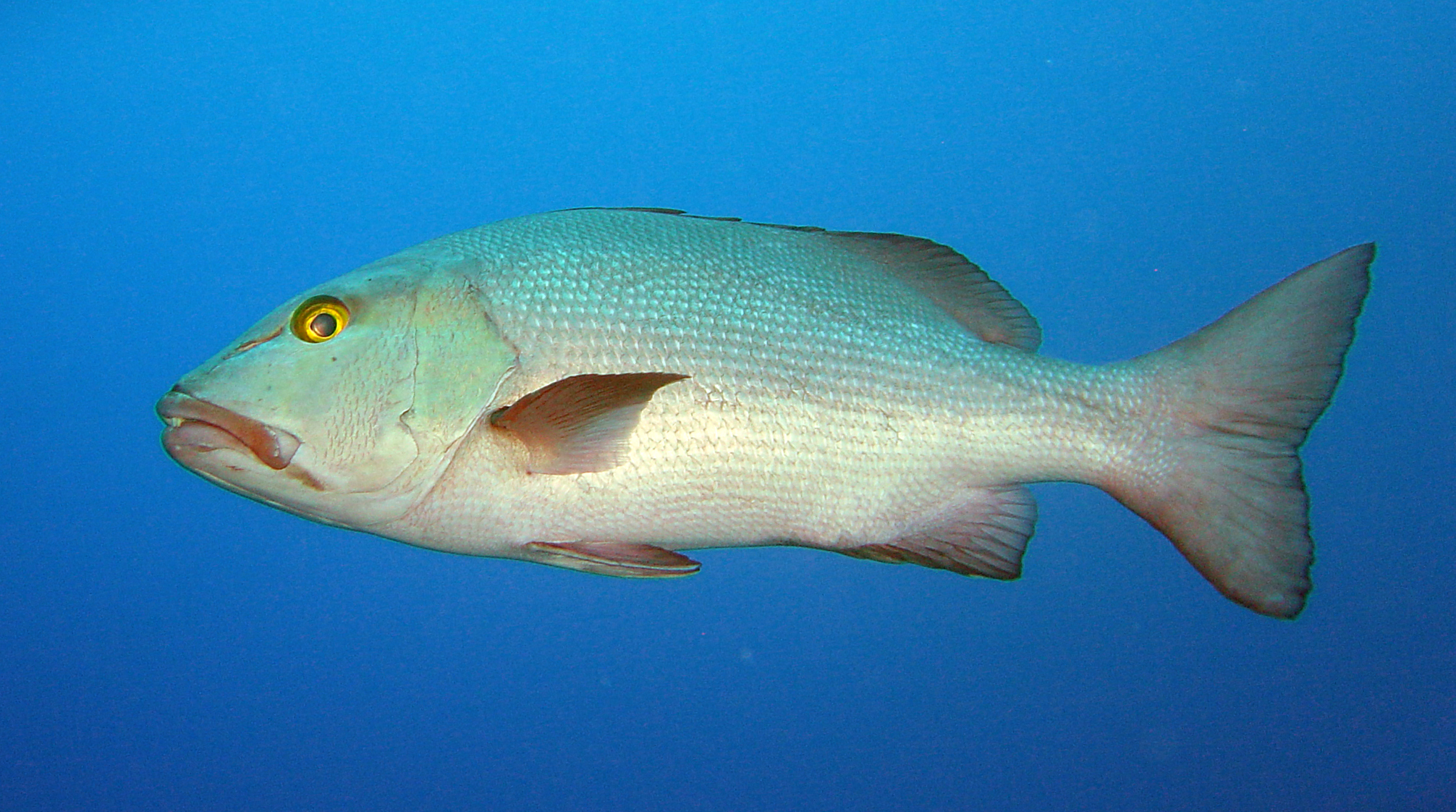
''Lutjanus'' is a genus of marine ray-finned fish, snappers belonging to the family Lutjanidae. They are found in the Atlantic, Indian, and Pacific Oceans. They are predatory fish usually found in tropical and subtropical reefs, and mangrove forests. This genus also includes two species that only occur in fresh and brackish waters. Taxonomy ''Lutjanus'' was created in 1790 by the German physician and zoologist Marcus Elieser Bloch with ''Lutjanus lutjanus'' as its type species by tautonymy. It is the type genus of the subfamily Lutjaninae and the family Lutjanidae. The name is derived from a local Indonesian name for snappers, ''ikhan Lutjang''. Bloch erroneously stated that the type locality for ''L. lutjanus'' was Japan when the name he gave it suggested that it was collected in the East Indies. A taxonomic study of snappers within the subfamily Lutjaninae in the tropical western Atlantic Ocean indicated that the at monotypic genera ''Ocyurus'' and ''Rhomboplites'' sit within ... [...More Info...] [...Related Items...] OR: [Wikipedia] [Google] [Baidu] |
Caranx
''Caranx'' is a genus of tropical to subtropical marine fishes in the jack family Carangidae, commonly known as jacks, trevallies and kingfishes. They are moderate- to large-sized, deep-bodied fishes which are distinguished from other carangid genera by specific gill raker, fin ray and dentition characteristics. The genus is represented in the Pacific, Indian and Atlantic Oceans, inhabiting both inshore and offshore regions, ranging from estuaries and bays to deep reefs and offshore islands. All species are powerful predators, taking a variety of fish, crustaceans and cephalopods, while they in turn are prey to larger pelagic fishes and sharks. A number of fish in the genus have a reputation as powerful gamefish and are highly sought by anglers. They often make up high amounts of the catch in various fisheries, but are generally considered poor to fair table fishes. Taxonomy and naming The genus ''Caranx'' is one of 30 currently recognised genera of fish in the jack and horse ... [...More Info...] [...Related Items...] OR: [Wikipedia] [Google] [Baidu] |
Bottlenose Dolphin
Bottlenose dolphins are aquatic mammals in the genus ''Tursiops.'' They are common, cosmopolitan members of the family Delphinidae, the family of oceanic dolphins. Molecular studies show the genus definitively contains two species: the common bottlenose dolphin (''Tursiops truncatus'') and the Indo-Pacific bottlenose dolphin (''Tursiops aduncus''). Others, like the Burrunan dolphin (''Tursiops (aduncus) australis''), may be alternately considered their own species or be subspecies of ''T. aduncus''. Bottlenose dolphins inhabit warm and temperate seas worldwide, being found everywhere except for the Arctic and Antarctic Circle regions. Their name derives from the Latin ''tursio'' (dolphin) and ''truncatus'' for their characteristic truncated teeth. Numerous investigations of bottlenose dolphin intelligence have been conducted, examining mimicry, use of artificial language, object categorization, and self-recognition. They can use tools (sponging; using marine sponges to forage ... [...More Info...] [...Related Items...] OR: [Wikipedia] [Google] [Baidu] |
Humpback Dolphin
Humpback dolphins are members of the genus ''Sousa''. These dolphins are characterized by the conspicuous humps and elongated dorsal fins found on the backs of adults of the species. They are found close to shore along the coast of West Africa (Atlantic species/variety) and right along the coast of the Indian Ocean from South Africa to Australia (Indo-Pacific species/varieties). Several institutions have made a proposal to divide the Indo-Pacific species into two distinct species: the Indo-Pacific humpback dolphin and the Australian humpback dolphin. Description The humpback dolphin is a coastal dolphin that can be found along the coast of Africa and India south to Australia, areas differing for separate varieties. The humpback dolphin has a hump ahead of the dorsal fin, as well as a careen on a ventral side. The dorsal fin of the humpback dolphin is to some degree falcate. The pectoral fins are considerably small and the tail flukes have a well-defined median notch. On each ... [...More Info...] [...Related Items...] OR: [Wikipedia] [Google] [Baidu] |
Ocypode Cursor
''Ocypode cursor'', the tufted ghost crab, is a species of ghost crab found on sandy beaches along the coasts of the eastern Atlantic Ocean and eastern Mediterranean Sea. Description ''Ocypode cursor'' can reach a carapace width of . ''O. cursor'' can be distinguished from '' O. ceratophthalma'' and other species of ''Ocypode'' by the presence of a tuft of setae (bristles) extending from the tips of the eyestalks. Distribution ''Ocypode cursor'' has a disjunct distribution, comprising the eastern Mediterranean Sea and tropical parts of the eastern Atlantic Ocean, but not the western Mediterranean Sea which connects them. It is thought that ''O. cursor'' entered the Mediterranean Sea during a warm period, but was restricted to the warmer eastern part during a subsequent cooler period, isolating the two populations. Similar patterns are seen in the sea snail ''Charonia variegata'' and the sea anemone '' Telmatactis cricoides''. Its range is apparently expanding ... [...More Info...] [...Related Items...] OR: [Wikipedia] [Google] [Baidu] |
Monitor Lizard
Monitor lizards are lizards in the genus ''Varanus,'' the only extant genus in the family Varanidae. They are native to Africa, Asia, and Oceania, and one species is also found in the Americas as an invasive species. About 80 species are recognized. Monitor lizards have long necks, powerful tails and claws, and well-developed limbs. The adult length of extant species ranges from in some species, to over in the case of the Komodo dragon, though the extinct varanid known as megalania (''Varanus priscus'') may have been capable of reaching lengths more than . Most monitor species are terrestrial, but arboreal and semiaquatic monitors are also known. While most monitor lizards are carnivorous, eating eggs, smaller reptiles, fish, birds, insects, and small mammals, some also eat fruit and vegetation, depending on where they live. Distribution The various species cover a vast area, occurring through Africa, the Indian subcontinent, to China, the Ryukyu Islands in southern Japan, s ... [...More Info...] [...Related Items...] OR: [Wikipedia] [Google] [Baidu] |


