|
Pocumtuck Mountain
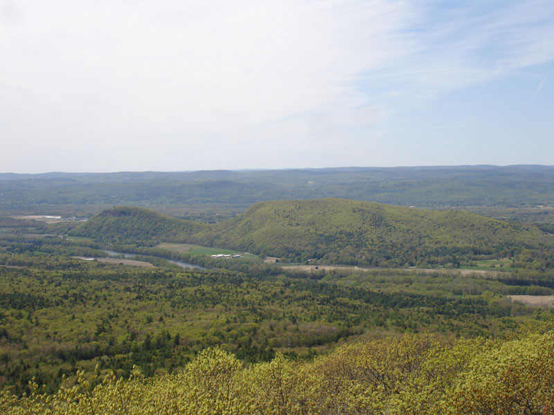
:''Should not be confused with the Pocumtuck Range (Pocumtuck Ridge) of Deerfield and Greenfield, Massachusetts'' Pocumtuck Mountain, a mountain peak in Charlemont, Massachusetts, located west of the abandoned Catamount settlement. Its summit ledge features wide views of western Franklin County and northern Berkshire County. Pocumtuck Mountain is often confused with the nearby Pocumtuck Range in Deerfield, Massachusetts Deerfield is a New England town, town in Franklin County, Massachusetts, Franklin County, Massachusetts, United States. Settled near the Connecticut River in the 17th century during the colonial era, the population was 5,090 as of the 2020 census. .... The mountain was named after the Pocumtuc Indians on October 16, 1855 during one of Catamount's Old Homes Days Festival. Such festivals were held often on the scenic mountain - including one visited by Massachusetts Governor John Davis Long. Except for areas belonging to Catamount State forest, the ledges and ... [...More Info...] [...Related Items...] OR: [Wikipedia] [Google] [Baidu] |
Pocumtuck Range
The Pocumtuck Range, also referred to as the Pocumtuck Ridge, is the northernmost subrange of the Metacomet Ridge mountain range of southern New England. Located in Franklin County, Massachusetts, between the Connecticut River and the Deerfield River valleys, the Pocumtuck Range is a popular hiking destination known for its continuous high cliffs, scenic vistas, and microclimate ecosystems.''Massachusetts Trail Guide, 8th ed.'' Appalachian Mountain Club, 2004, Boston.Farnsworth, Elizabeth J"Metacomet-Mattabesett Trail Natural Resource Assessment.", 2004. PDF file. Cited Nov. 20, 2007Zen, E-an, Goldsmith, Richard, Ratcliffe, N.M., Robinson, Peter, Stanley, R.S., Hatch, N.L., Shride, A.F., Weed, E.G.A., and Wones, D.R. ''Bedrock Geologic Map of Massachusetts'' USGS. 1983 Geography The range, 11 miles (18 km) long by 1.75 miles (2.8 km) wide at its widest point, includes, from south to north, Sugarloaf Mountain of Deerfield; a central high ridge most often called ''Pocumt ... [...More Info...] [...Related Items...] OR: [Wikipedia] [Google] [Baidu] |
Charlemont, Massachusetts
Charlemont is a town in Franklin County, Massachusetts, United States. The population was 1,185 at the 2020 census. It is part of the Springfield, Massachusetts Metropolitan Statistical Area. History Charlemont was first colonized by Moses Rice (1694–1755) who purchased on 23 April 1743 that been previously set off as Boston Township Number 1 in 1735 by the Great and General Court. The town was along the distant frontier at the time, and was the subject of several raids by Native Americans. While plowing in the fields one day, Rice was shot and wounded by Indians lying in ambush. They also shot and killed another man, Phineas Arms, at the same time and captured Moses' eight-year-old grandson Asa, who had been riding the plow horse. Moses was taken to the adjoining woods, scalped, and left for dead, but Asa was carried off to Canada. The town was incorporated as Charlemont in 1765, most likely named for the town in County Armagh, Ulster, Ireland. The town was mostly rural, ... [...More Info...] [...Related Items...] OR: [Wikipedia] [Google] [Baidu] |
Massachusetts
Massachusetts (Massachusett language, Massachusett: ''Muhsachuweesut [Massachusett writing systems, məhswatʃəwiːsət],'' English: , ), officially the Commonwealth of Massachusetts, is the most populous U.S. state, state in the New England region of the Northeastern United States. It borders on the Atlantic Ocean and Gulf of Maine to the east, Connecticut and Rhode Island to the south, New Hampshire and Vermont to the north, and New York (state), New York to the west. The state's capital and List of municipalities in Massachusetts, most populous city, as well as its cultural and financial center, is Boston. Massachusetts is also home to the urban area, urban core of Greater Boston, the largest metropolitan area in New England and a region profoundly influential upon American History of the United States, history, academia, and the Economy of the United States, research economy. Originally dependent on agriculture, fishing, and trade. Massachusetts was transformed into a manuf ... [...More Info...] [...Related Items...] OR: [Wikipedia] [Google] [Baidu] |
Catamount, Massachusetts
Catamount is a former village of Colrain, Massachusetts. In 1812, the schoolhouse that once stood in Catamount was the first schoolhouse to fly the United States Flag. From the mid 18th century until the late 19th century, Catamount was mainly a farming community. Nearby Pocumtuck Mountain was often a popular destination for people around the state. In 1880, the Old Home Days festival on Pocumtuck Mountain was visited by Massachusetts Governor John Davis Long. Due in part to the remote, mountainous location, Catamount was abandoned in the early 20th century. Much of the land was acquired by the Commonwealth of Massachusetts in 1967, leading to the creation of the Catamount State Forest. Catamount is currently accessible to hikers and snowmobilers. McLeod Pond is a popular destination for local fishers and canoers. Catamount State Forest is managed by the Mohawk Trail State Forest Mohawk Trail State Forest is a publicly owned state forest in Massachusetts with recreation ... [...More Info...] [...Related Items...] OR: [Wikipedia] [Google] [Baidu] |
Franklin County, Massachusetts
Franklin County is a nongovernmental county located in the northwestern part of the U.S. state of Massachusetts. As of the 2020 census, the population was 71,029, which makes it the least-populous county on the Massachusetts mainland, and the third-least populous county in the state. Its traditional county seat and most populous city is Greenfield. Its largest town by area is New Salem. Franklin County comprises the Greenfield Town, MA Micropolitan Statistical Area, which is included in the Springfield-Greenfield Town, MA Combined Statistical Area. History Franklin County was created on June 24, 1811, from the northern third of Hampshire County. It was named for Benjamin Franklin. Franklin County's government was abolished by the state government in 1997, at the county's request. Law and government Like several other Massachusetts counties, Franklin County exists today only as a geographic region and has no county government. The Franklin County Commission voted itself out ... [...More Info...] [...Related Items...] OR: [Wikipedia] [Google] [Baidu] |
Berkshire County, Massachusetts
Berkshire County (pronounced ) is a county on the western edge of the U.S. state of Massachusetts. As of the 2020 census, the population was 129,026. Its largest city and traditional county seat is Pittsfield. The county was founded in 1761. The Berkshire Hills are centered on Berkshire County. Residents are known as Berkshirites. It exists today only as a historical geographic region, and has no county government, with the exception of the retirement board for former county workers, and certain offices such as the sheriff and registry of deeds. Law and government Of the fourteen Massachusetts counties, Berkshire County is one of eight that exists today only as a historical geographic region; it has limited county government. Berkshire County government was abolished effective July 1, 2000. Most former county functions were assumed by state agencies, and there is no county council or commission. [...More Info...] [...Related Items...] OR: [Wikipedia] [Google] [Baidu] |
Deerfield, Massachusetts
Deerfield is a New England town, town in Franklin County, Massachusetts, Franklin County, Massachusetts, United States. Settled near the Connecticut River in the 17th century during the colonial era, the population was 5,090 as of the 2020 census. Deerfield is part of the Springfield, Massachusetts Springfield, Massachusetts, metropolitan area, Metropolitan Statistical Area in western Massachusetts, lying north of the city of Springfield. Deerfield includes the villages of South Deerfield, Massachusetts, South Deerfield and Old Deerfield, which is home to two museums: Pocumtuck Valley Memorial Association and Historic Deerfield, Inc. Historic Deerfield is designated as a National Historic Landmark district, and the organization operates a museum with a focus on decorative arts, early American material culture, and history. Its eleven house museums offer interpretation of society, history, and culture from the colonial era through the late nineteenth century. The Pocumtuck Valley M ... [...More Info...] [...Related Items...] OR: [Wikipedia] [Google] [Baidu] |
Pocumtuc
The Pocumtuc (also Pocomtuck or Deerfield Indians) were a Native American tribe historically inhabiting western areas of Massachusetts. Settlements Their territory was concentrated around the confluence of the Deerfield and Connecticut Rivers in today's Franklin County. Their homelands also included much of current-day Hampden and Hampshire Counties, plus areas now in northern Connecticut and southern Vermont. Their principal village, also known as Pocumtuck, was in the vicinity of the present day village of Deerfield. Language Their language, now extinct, was an R-dialect of the Algonquian language family, most likely related to the Wappinger and nearby Mahican tribes of the Hudson River Valley.Swanton, John R. ''The Indian Tribes of North America'', pp. 23-24. Smithsonian Institution Bureau of American Ethnology Bulletin 145. Washington DC.: Government Printing Office, 1952. Subsistence Little is known about the Pocumtuc people, but they likely led lifestyles sim ... [...More Info...] [...Related Items...] OR: [Wikipedia] [Google] [Baidu] |
John Davis Long
John Davis Long (October 27, 1838 – August 28, 1915) was an American lawyer, politician, and writer from Massachusetts. He was the 32nd Governor of Massachusetts, serving from 1880 to 1883. He later served as the Secretary of the Navy from 1897 to 1902, a period that included the primarily naval Spanish–American War. Born in Buckfield, Maine, Long was educated as a lawyer at Harvard University, later settling in Hingham, Massachusetts. He became active in Republican Party politics in the 1870s, winning election for the state legislature in 1874. He rose rapidly in prominence, and was elected lieutenant governor in 1879 and governor in 1880. He advocated modest reforms during his three years as governor, which were relatively uneventful. After returning to private practice he was offered a cabinet post by his friend, President William McKinley, in 1896. He chose to become Secretary of the Navy despite lacking detailed knowledge of naval matters. He clashed with his Under-S ... [...More Info...] [...Related Items...] OR: [Wikipedia] [Google] [Baidu] |
Mountains Of Franklin County, Massachusetts
A mountain is an elevated portion of the Earth's crust, generally with steep sides that show significant exposed bedrock. Although definitions vary, a mountain may differ from a plateau in having a limited summit area, and is usually higher than a hill, typically rising at least 300 metres (1,000 feet) above the surrounding land. A few mountains are isolated summits, but most occur in mountain ranges. Mountains are formed through tectonic forces, erosion, or volcanism, which act on time scales of up to tens of millions of years. Once mountain building ceases, mountains are slowly leveled through the action of weathering, through slumping and other forms of mass wasting, as well as through erosion by rivers and glaciers. High elevations on mountains produce colder climates than at sea level at similar latitude. These colder climates strongly affect the ecosystems of mountains: different elevations have different plants and animals. Because of the less hospitable terrain and ... [...More Info...] [...Related Items...] OR: [Wikipedia] [Google] [Baidu] |
Mountains Of Massachusetts
This is a list of some of the mountains in the U.S. state of Massachusetts, including those in the mountain range known as the Berkshires. Mount Greylock is the highest point in the state at 3,491 feet (1,064 m) in elevation. As such, no mountains in Massachusetts are recognized by the Appalachian Mountain Club in its list of Four-thousand footers — a list of New England peaks over 4,000 feet with a minimum 200 feet of topographic prominence. Thousands of named summits in Massachusetts (including mountains and hills) are recognized by the USGS. List Mountain ranges in Massachusetts *Appalachian Mountains *The Berkshires *Hoosac Range *Taconic Mountains * Metacomet Ridge *Wapack Range See also * Geography of Massachusetts *List of mountains of the Appalachians References External linksMassachusetts highest named summits {{Mountains of Massachusetts * Mountains Massachusetts Massachusetts Massachusetts (Massachusett language, Massachusett: ''Muhsachuweesut assac ... [...More Info...] [...Related Items...] OR: [Wikipedia] [Google] [Baidu] |


