|
Pleinfeld Station
Pleinfeld station is at a railway junction on the Nuremberg–Augsburg railway in the market town of Pleinfeld in the German state of Bavaria. It is classified by Deutsche Bahn as a category 4 station and has five platform tracks. The Gunzenhausen–Pleinfeld railway, which is now a secondary line, was built as part of the Ludwig South-North Railway, which reached Pleinfeld in 1849, 20 years before the line from Treuchtlingen, which forms part of the modern main line. History The law authorising the construction of the Ludwig South-North Railway was adopted on 25 August 1843. The Bavarian King Ludwig I's decision that the line would run from Donauwörth via Nördlingen and Gunzenhausen to Nuremberg was proclaimed on 7 October. The Bavarian government confirmed this decision on 21 February 1844. The first land was acquired in the Pleinfeld area on 23 September 1845. A contract was awarded for the production of “objects” for Pleinfeld station on 28 February 1849 and the tra ... [...More Info...] [...Related Items...] OR: [Wikipedia] [Google] [Baidu] |
Verkehrsverbund Großraum Nürnberg
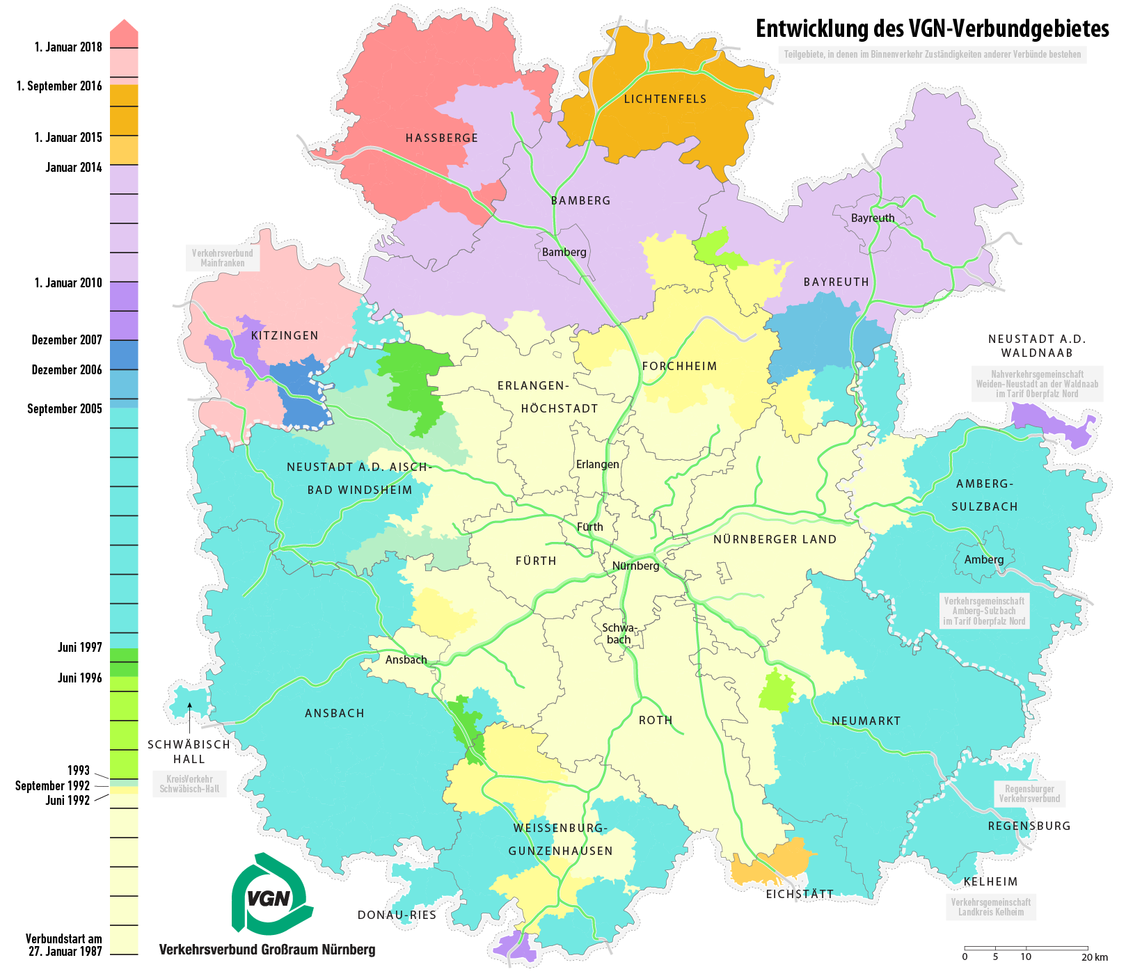
The (VGN; Transport Association Region Nuremberg) is the transit authority of the city of Nuremberg, the second largest city of the German state of Bavaria. Its jurisdiction covers the city and its surrounding area, responsible for the Nuremberg S-Bahn commuter trains, the Nuremberg U-Bahn, the Nuremberg tramway and buses. While not co-extensive with the wider Nuremberg Metropolitan Region, it covers most of it with the exception of several smaller towns and rural areas on the periphery, as well as Sonneberg in the neighboring state of Thuringia. The VGN coordinates transport and fares in area comprising the city of Nuremberg, Fürth, Erlangen, Schwabach, Bayreuth, Bamberg, Ansbach, Amberg and 17 surrounding districts. It is jointly owned by the state of Bavaria, by the city of Nuremberg, Fürth, Erlangen, Schwabach, Bayreuth, Bamberg, Ansbach, Amberg and the 17 surrounding districts, which are: * Landkreis Ansbach * Landkreis Amberg-Sulzbach * Landkreis Bamberg * Landkreis Bay ... [...More Info...] [...Related Items...] OR: [Wikipedia] [Google] [Baidu] |
Nuremberg
Nuremberg ( ; german: link=no, Nürnberg ; in the local East Franconian dialect: ''Nämberch'' ) is the second-largest city of the German state of Bavaria after its capital Munich, and its 518,370 (2019) inhabitants make it the 14th-largest city in Germany. On the Pegnitz River (from its confluence with the Rednitz in Fürth onwards: Regnitz, a tributary of the River Main) and the Rhine–Main–Danube Canal, it lies in the Bavarian administrative region of Middle Franconia, and is the largest city and the unofficial capital of Franconia. Nuremberg forms with the neighbouring cities of Fürth, Erlangen and Schwabach a continuous conurbation with a total population of 800,376 (2019), which is the heart of the urban area region with around 1.4 million inhabitants, while the larger Nuremberg Metropolitan Region has approximately 3.6 million inhabitants. The city lies about north of Munich. It is the largest city in the East Franconian dialect area (colloquially: "F ... [...More Info...] [...Related Items...] OR: [Wikipedia] [Google] [Baidu] |
Hilpoltstein
Hilpoltstein () is a town in the district of Roth, in Bavaria, Germany. It is situated 10 km southeast of Roth bei Nürnberg and 30 km south of Nuremberg, close to the lake 'Rothsee. History * Origins of the castle and the town date back to the 10th century. * Town privileges were granted in 1354. * 1799, Hilpoltstein becomes part of Bavaria Sights * Rathaus (Town Hall) * Accessible Tower of the Remains of the early medieval Castle * Remains of The Town Wall * Church of Saint John the Baptist (Town's Parish Church) * Jahrsdorfer House * Guest House 'Schwarzes Ross' with historic Brewery and museum on handcrafts and town history Sons and daughters of the place * Johann Christoph Sturm (1635–1703), astronomer and mathematician * Friedrich Eibner (1825–1877), painter People who work or have worked on the ground * Ludwig Elsbett (1913–2003), engineer and inventor of the Elsbett engine Annual Events * Spring Concert of the town's brass band (April) * Medieval festival with ... [...More Info...] [...Related Items...] OR: [Wikipedia] [Google] [Baidu] |
Schwandorf
Schwandorf is a town on the river Naab in the Upper Palatinate, Bavaria, Germany, which is the seat of the Schwandorf district. Sights * Catholic parish church of St. Jakob * Kreuzberg Church: Catholic parish, monastic and pilgrimage church of Mary Help of Christians on the Kreuzberg Politics Schwandorf (electoral district) Sports The towns association football club, 1. FC Schwandorf, experienced its greatest success in the late 1950s and 1960 when it spent thirteen seasons in the third division Bayernliga. Twin towns – sister cities Schwandorf is twinned with: * Libourne Libourne (; oc, label= Gascon, Liborna ) is a commune in the Gironde department in Nouvelle-Aquitaine in southwestern France. It is a sub-prefecture of the department. It is the wine-making capital of northern Gironde and lies near Saint-Émil ..., France * Sokolov, Czech Republic References Schwandorf (district) {{Schwandorfdistrict-geo-stub ... [...More Info...] [...Related Items...] OR: [Wikipedia] [Google] [Baidu] |
Dietfurt
Dietfurt is a town in the district of Neumarkt in Bavaria, Germany. The town is situated on the river Altmühl, and is 38 km west of Regensburg, 30 km north of Ingolstadt, and is located 364 meters above sea level. Overview Dietfurt is known as the "Bavarian China" (german: Bayerisch China, ), Chinese culture is the theme adopted for Carnival in Dietfurt, and the city promotes other Chinese cultural activities such as courses in Qigong. Mayor The mayor of Dietfurt is Bernd Mayr, elected in March 2020. Notable people * Argula von Grumbach, (1492-1568) Protestant publicist and reformer, lived and worked in Dietfurt from 1516 onwards * Michael Wittmann Michael Wittmann (22 April 19148 August 1944) was a German Waffen-SS tank commander during the Second World War. He is known for his ambush of elements of the British 7th Armored Division during the Battle of Villers-Bocage on 13 June 1944. Whi ... (1914-1944), German Panzer commander and panzer ace of th ... [...More Info...] [...Related Items...] OR: [Wikipedia] [Google] [Baidu] |
Beilngries
Beilngries (; bar, Beilngrias) is a town in the district of Eichstätt, in Bavaria, Germany. It is situated on the river Altmühl and the Rhine-Main-Danube Canal, 30 km north of Ingolstadt. Sons and daughters of the city * Rosa Aschenbrenner (1885-1967), socialist politician, member of the Bavarian Landtag 1921-1932 and 1946-1948 * Karl Harrer (1890-1926), sport journalist and founding member and party chairman of the German Workers' Party The German Workers' Party (german: Deutsche Arbeiterpartei, DAP) was a short-lived far-right political party established in Weimar Germany after World War I. It was the precursor of the Nazi Party, which was officially known as the National Soci ..., the predecessor organization of the Nationalsozialistische Deutschen Arbeiterpartei (NSDAP) References Eichstätt (district) {{Eichstätt-geo-stub ... [...More Info...] [...Related Items...] OR: [Wikipedia] [Google] [Baidu] |
Greding
Greding () is a town in the district of Roth, in Bavaria, Germany. It is situated 28 km southeast of Roth bei Nürnberg and 32 km north of Ingolstadt. Geography Greding is located in the south-eastern corner of Middle Franconia. The municipal area borders on two neighbouring Bavarian districts, Eichstätt and Neumarkt, and also on the two regions of Upper Bavaria and Upper Palatinate. Greding is situated about 32 km north of the city of Ingolstadt on the A9 Autobahn (junction 57). Greding stands on the river Schwarzach in the Altmühl Valley Nature Park. Two hills around the town are the Kalvarienberg and the Galgenberg. The township of Greding includes the villages of Attenhofen, Birkhof, Esselberg, Euerwang, Grafenberg, Großhöbing, Günzenhofen, Hausen, Heimbach, Herrnsberg, Hofberg, Kaising, Kleinnottersdorf, Kraftsbuch, Landerzhofen, Linden, Mettendorf, Obermässing, Österberg, Röckenhofen, Schutzendorf, Untermässing and Viehhausen. Neighbouring townsh ... [...More Info...] [...Related Items...] OR: [Wikipedia] [Google] [Baidu] |
Heideck
Heideck is a town with full legal town charter in the district of Roth, in Bavaria, Germany. It is situated in the Metropolitan Area of Nuremberg and at the same time in the Franconian Lake District. History Heideck was first mentioned in 1288. Mayors * 1945-1948: Georg Stücklen ( CSU) * 1948-1972: Johann "Hans" Stücklen (CSU) * 1972-1990: Benno Eckert (CSU) * 1990-2002: Hans Herger (Free voters Bavaria) * 2002-2014: Ottmar Brunner (CSU) * From 2014 onwards: Ralf Beyer (Free voters Heideck) Notable people * Richard Stücklen (20 August 1916 - 2 May 2002): German politician ( CSU), President of the Bundestag The president of the Bundestag (german: Präsident des Deutschen Bundestages or ) presides over the sessions of the Bundestag, the federal parliament of Germany, with functions similar to that of a speaker in other countries. In the German orde ..., Federal Minister for Post and Communication References External links Official site Roth (district) {{ ... [...More Info...] [...Related Items...] OR: [Wikipedia] [Google] [Baidu] |
Kelheim
Kelheim () is a town and municipality in Bavaria, Germany. It is the capital of the district Kelheim and is situated at the confluence of the rivers Altmühl and Danube. Kelheim has a population of around 16,750 (2020). History Kelheim is the site of a large Iron Age oppidum from the La Tène period, which has been tentatively identified with the Celtic city of Alcimoennis mentioned by Ptolemy in his ''Geography''. The ramparts of the fort cross the promontory between the rivers Altmühl and Danube. There is an inner defensive line enclosing 60 ha near the confluence, then a long outer rampart enclosing an enormous area of 630 ha. A small promontory fort on the other bank of the Danube has a series of short linear ramparts protecting a settlement in the bend of a meander. This is aligned with the end of the outer rampart on the far bank, dominating traffic on the river. Kelheim has given its name to the ''pfostenschlitzmauer'' style of rampart construction characterized ... [...More Info...] [...Related Items...] OR: [Wikipedia] [Google] [Baidu] |
Railway Turntable
In rail terminology, a railway turntable or wheelhouse is a device for turning railway rolling stock, usually locomotives, so that they can be moved back in the direction from which they came. Naturally, it is especially used in areas where economic considerations or a lack of sufficient space have served to weigh against the construction of a turnaround wye. In the case of steam locomotives, railways needed a way to turn the locomotives around for return trips as their controls were often not configured for extended periods of running in reverse and in many locomotives the top speed was lower in reverse motion. In the case of diesel locomotives, though most can be operated in either direction, they are treated as having "front ends" and "rear ends" (often determined by reference to the location of the crew cab). When operated as a single unit, the railway company often prefers, or requires, that a diesel locomotive is run "front end" first. When operated as part of a multiple ... [...More Info...] [...Related Items...] OR: [Wikipedia] [Google] [Baidu] |
Water Crane
A water crane is a device used for delivering a large volume of water into the tank or tender of a steam locomotive. The device is also called a water column in the United States and Australia. As a steam locomotive consumes large quantities of water, water cranes were a vital part of railway station equipment, often situated at the end of a platform, so that water could be refilled during a stop at the station. Overview Generally, water cranes consist of an upright steel pipe about in diameter with a horizontal, pivoting pipe connected to its upper end so as to form a swinging arm. The swinging arm is usually designed to rest parallel to the rails when not in use. Water cranes may be able to deliver up to of water per minute. Water supply In hilly country, natural streams can be dammed and water fed by gravity to the water crane. In flatter country this arrangement is not always possible, so water may be supplied by a tank next to the crane. Water tanks may vary in volume fro ... [...More Info...] [...Related Items...] OR: [Wikipedia] [Google] [Baidu] |


