|
Pihtipudas
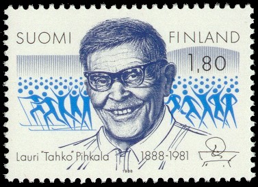
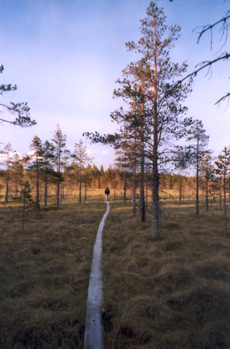
Pihtipudas is a municipality of Finland. It is located in northern Central Finland along the highway 4 ( E75), about north of Jyväskylä. The municipality has a population of () and covers an area of of which is water. There are all together 140 lakes in Pihtipudas. Biggest lakes are Alvajärvi, Muurasjärvi and Saanijärvi. The population density is . The municipality is unilingually Finnish. Pihtipudas is known for the annual javelin carnival and Lauri "Tahko" Pihkala, the father of Finnish baseball. Putaanportti area offers plenty of services for travelers. Fish Art is a sales exhibition of taxidermic (mounted fish) – unique in Finland. Close to the service station there are shops – in a way factory outlets – specialized in sweets, leather bags and pottery products. Other tourist services are found in the central village and lakeside areas. History Pihtipudas was first mentioned in 1552 as ''Pictipudhas'', when it was a part of the large Rautalampi parish. A ... [...More Info...] [...Related Items...] OR: [Wikipedia] [Google] [Baidu] |
Central Finland
Central Finland ( fi, Keski-Suomi; sv, Mellersta Finland) is a region ( / ) in Finland. It borders the regions of Päijät-Häme, Pirkanmaa, South Ostrobothnia, Central Ostrobothnia, North Ostrobothnia, North Savo, and South Savo. The city of Jyväskylä is the regional centre and by far the largest city in the area. The largest lake in the very water-based region is Lake Päijänne (1,080 km2). Other large lakes are Lake Keitele (490 km2), Lake Konnevesi (190 km2) and Lake Kivijärvi (150 km2). The highest point in the region is Kiiskilänmäki in the municipality of Multia, which reaches an altitude of 269 meters above sea level. Kuokanjoki, Finland's shortest river and one of the world's shortest rivers is in the region. Central Finland has been one of the slowly growing regions in terms of population, but the growth has been based on the Jyväskylä sub-region's position as a significant growth center, and most of the region's municipalities are declining in p ... [...More Info...] [...Related Items...] OR: [Wikipedia] [Google] [Baidu] |
Saanijärvi
Saanijärvi is a medium-sized lake of Finland. It is situated in Pihtipudas in Central Finland and it belongs to the Kymijoki main catchment area. Retrieved 2014-02-27. See also *List of lakes in Finland
There are 187,888 lakes in Finland larger than 5 ares (500 square metres / 5,382 sq.ft.) Most are small, but there are 309 lakes or reservoirs larger than 10 km². They are listed here along with some smaller noteworthy lakes.
Alphabetica ...
References {{WesternFinland-geo-stub[...More Info...] [...Related Items...] OR: [Wikipedia] [Google] [Baidu] |
Lauri Pihkala
Lauri "Tahko" Pihkala (born Gummerus, 5 January 1888 – 20 May 1981) was the inventor of pesäpallo, the Finnish variant of baseball. In 1969 he became one of the first persons to receive an honorary doctorate in Sport Sciences from the University of Jyväskylä, together with president Urho Kekkonen and Professor Kaarina Kari. Athletics In the 1910s he became the first Finnish professional coach in athletics, and also worked as a physical education instructor with the Finnish Army.Lauri Pihkala (1888-1981) Suomen urheilun Hall of Fame Pihkala was known for being an avid sports fan, and he developed several outdoor games. Other During theFinnish Civil War
[...More Info...] [...Related Items...] OR: [Wikipedia] [Google] [Baidu] |
Muurasjärvi
Muurasjärvi is a medium-sized lake of Central Finland. It belongs to the Kymijoki main catchment area. It is located in the region Keski-Suomi in Pihtipudas municipality. See also *List of lakes in Finland There are 187,888 lakes in Finland larger than 5 ares (500 square metres / 5,382 sq.ft.) Most are small, but there are 309 lakes or reservoirs larger than 10 km². They are listed here along with some smaller noteworthy lakes. Alphabetica ... References * (English version may be available.) Landforms of Central Finland Lakes of Pihtipudas {{WesternFinland-geo-stub ... [...More Info...] [...Related Items...] OR: [Wikipedia] [Google] [Baidu] |
Viitasaari
Viitasaari is a town and municipality of Finland. It is located in the Central Finland region. The town has a population of () and covers an area of of which is water. There are all together 230 lakes in Viitasaari. Biggest lakes are Lake Keitele, Lake Kolima and Muuruejärvi. The population density is . The municipality is unilingually Finnish. Politics Results of the 2011 Finnish parliamentary election in Viitasaari: * Centre Party 32.5% * Social Democratic Party 26.2% * True Finns 16.6% * National Coalition Party 9.9% * Left Alliance 5.5% * Christian Democrats 5.5% * Green League 2.6% Sister cities The following cities or municipalities are twinned with Viitasaari: * Nõo Parish, Estonia * Staffanstorp Municipality, Sweden * Storuman Municipality, Sweden * Sør-Odal, Norway * Schlangen, Germany * Rokietnica, Poland See also * Blue Highway Blue Highway is an American contemporary bluegrass band formed in 1994 and based in Tennessee. The band's ... [...More Info...] [...Related Items...] OR: [Wikipedia] [Google] [Baidu] |
Kivijärvi
Kivijärvi (; literally "stone lake") is a municipalities of Finland, municipality of Finland. It is located in the Central Finland regions of Finland, region. The municipality has a population of () and covers an area of of which is water. The population density is . Neighbouring municipalities are Kannonkoski, Karstula, Kinnula, Kyyjärvi, Perho and Viitasaari. The municipality is unilingually Finnish language, Finnish. The municipal coat of arms of Kivijärvi is inspired by a Folklore, folktale related to Kivijärvi's church. According to the story, the construction work of the first Church (building), church building did not progress when all the work done during the day was mysteriously destroyed during the night. In that case, it was decided that the site of the church would be chosen by putting a rooster on the back of the lake to drift on top of the bottom log of the church, and where the rooster would land, the church of parish would be erected there. The coat of arms ... [...More Info...] [...Related Items...] OR: [Wikipedia] [Google] [Baidu] |
Konginkangas
Konginkangas is a settlement and former municipality of Finland in the Central Finland region. It was consolidated with Äänekoski in 1993. The municipality bordered Äänekoski, Saarijärvi, Kannonkoski, Viitasaari, Vesanto, Konnevesi and Sumiainen. Until 1969, it bordered Äänekosken maalaiskunta instead of Äänekoski. The national road 4 goes through Konginkangas and the distance between Äänekoski proper and Konginkangas is about 20 km. Geography Villages *Konginkangas or Konginkankaan kirkonkylä *Riihilahti (~10 permanently inhabited houses) *Liimattala (~400 residents) *Laajaranta (~50 houses) *Räihä *Kalaniemi The area of the former municipality also has many summer houses. Lakes Konginkangas is located by the large lake Keitele. Smaller lakes include Rahkojärvi, Särkilampi, Ahvenlampi and Lekojärvi. History Name Konginkangas is named after the oldest farm in the area, named after the nearby terrain (''kangas'', a type of forest). The ''ko ... [...More Info...] [...Related Items...] OR: [Wikipedia] [Google] [Baidu] |
Regions Of Finland
Finland is divided into 19 regions ( fi, maakunta; sv, landskap)., smn, eennâmkodde, and sms, mäddkåʹdd. The regions are governed by regional councils that serve as forums of cooperation for the municipalities of each region. The councils are composed of delegates from the municipal councils. The main tasks of regional councils are regional planning, development of enterprises, and education. Between 2004 and 2012 the regional council of Kainuu was elected via popular elections as part of an experimental regional administration. In 2022 new wellbeing services counties were established as part of a health care and social services reform. The wellbeing services counties follow the regional borders, and are governed by directly elected county councils. Åland One region, Åland, has a special status and has a much higher degree of autonomy than the others, with its own Parliament and local laws, due to its unique history and the fact that the overwhelming majority o ... [...More Info...] [...Related Items...] OR: [Wikipedia] [Google] [Baidu] |
Kannonkoski
Kannonkoski is a municipality of Finland. It is located in the Central Finland region. The municipality has a population of () and covers an area of of which is water. The population density is . Neighbouring municipalities are Karstula, Kivijärvi, Saarijärvi, Viitasaari and Äänekoski. The municipality is unilingually Finnish. History Kannonkoski as a settlement name is very new, originally only referring to the rapids which connect the lake Kannonjärvi to the lake Kivijärvi. The toponym ''kannonn Maa'' was mentioned in 1552, referring to hunting grounds of the people of Sysmä in this area. The people of Pälkäne also had hunting grounds around the rapids and the name ''Kannonkoski'' may be derived from ''Kantokylä'', a village in Pälkäne. By 1558 the area had got permanent Savonian settlers, who established the village of ''Kantojärvi'' (transcribed as ''Kandoijerffuij''). Rautalampi, including this area, became a separate parish in 1561. Viitasaari was sepa ... [...More Info...] [...Related Items...] OR: [Wikipedia] [Google] [Baidu] |
Leirvík
Leirvík ( da, Lervig) is a town on the Faroe Islands and was an important regional ferry harbour at the east coast of the second-largest island Eysturoy. Leirvík has a population of 1,048 (2022). It was the only town in the municipality of Leirvík (''Leirvíkar kommuna''), however on 1 January 2009, it merged with Gøtu kommuna to make the new municipality called Eysturkommuna. Leirvík is important for its fishing industry. The Norðoyatunnilin, a submarine tunnel to Klaksvík to the east, was opened in April 2006. A district heating system pulls heat from the sea, increases the heat in a heat pump powered by electricity, and sends the heat to the large buildings in the town. History Archaeological excavations have shown that the town was first settled the 9th century by the Vikings. It is said that all inhabitants died in 1349 because of the Black Death. See also * Leirvik in Norway * Lerwick in the Shetland Islands * List of towns in the Faroe Islands This is a l ... [...More Info...] [...Related Items...] OR: [Wikipedia] [Google] [Baidu] |
Faroe Islands
The Faroe Islands ( ), or simply the Faroes ( fo, Føroyar ; da, Færøerne ), are a North Atlantic archipelago, island group and an autonomous territory of the Danish Realm, Kingdom of Denmark. They are located north-northwest of Scotland, and about halfway between Norway ( away) and Iceland ( away). The islands form part of the Kingdom of Denmark, along with mainland Denmark and Greenland. The islands have a total area of about with a population of 54,000 as of June 2022. The terrain is rugged, and the Oceanic climate#Subpolar variety (Cfc), subpolar oceanic climate (Cfc) is windy, wet, cloudy, and cool. Temperatures for such a northerly climate are moderated by the Gulf Stream, averaging above freezing throughout the year, and hovering around in summer and 5 °C (41 °F) in winter. The northerly latitude also results in perpetual civil twilight during summer nights and very short winter days. Between 1035 and 1814, the Faroe Islands were part of the Kingdo ... [...More Info...] [...Related Items...] OR: [Wikipedia] [Google] [Baidu] |


