|
Pawala Valley Ridge
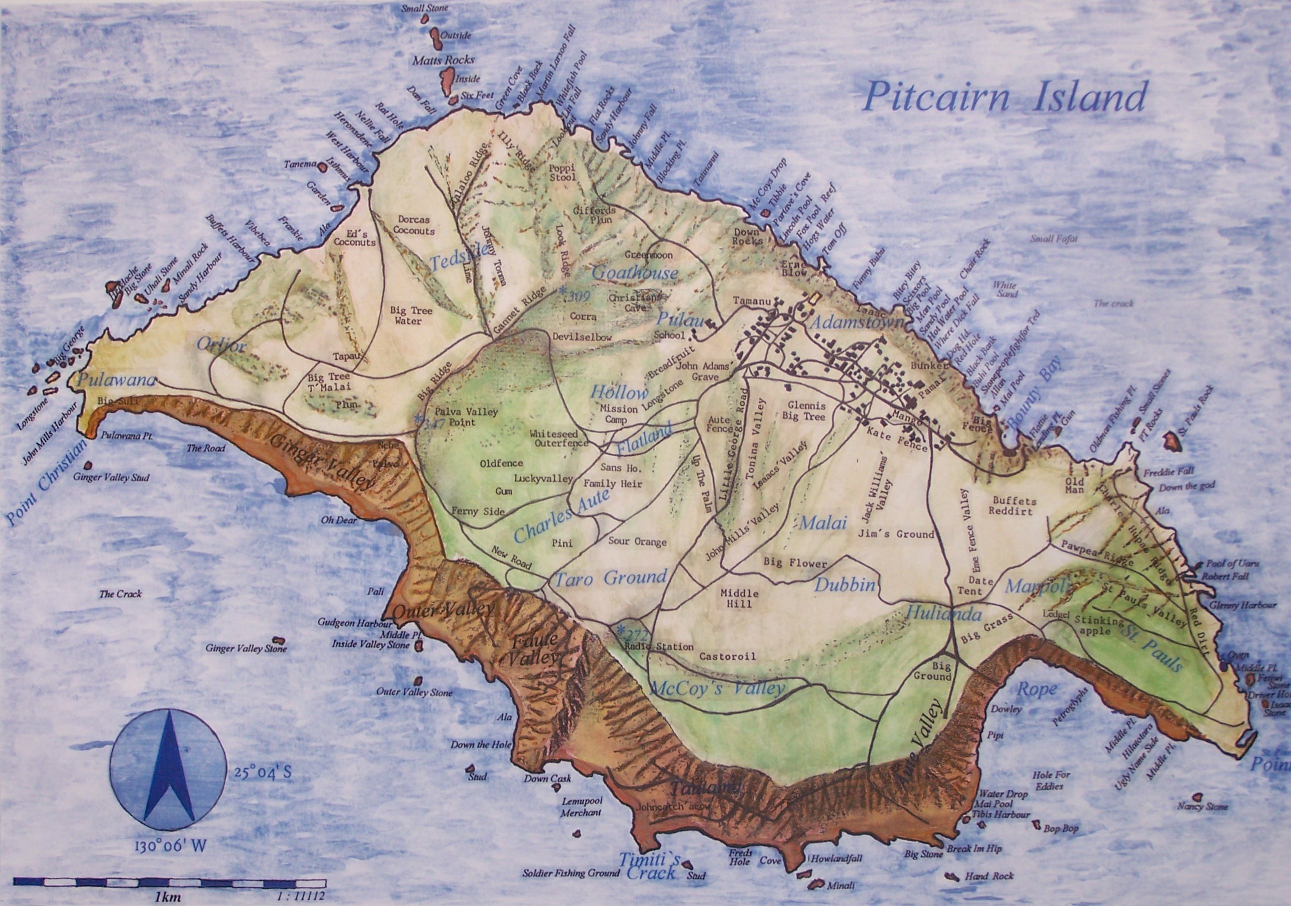
Pawala Valley Ridge, is the highest point of the Pitcairn Islands, a British overseas territory in the Pacific Ocean, with an elevation of 347 metres (1,138 ft). See also * Geography of the Pitcairn Islands The Pitcairn Islands consist of four islands: Pitcairn Island (a volcanic high island), Henderson Island (an uplifted coral island), and two coral atolls, Oeno Island and Ducie Island. The only inhabited island, Pitcairn, has an area of and a ... External links *Pawala Valley Ridge, Pitcairn Island Peakbagger.com. Pawala Valley Ridge Landforms of Oceania Ridges {{pitcairn-geo-stub ... [...More Info...] [...Related Items...] OR: [Wikipedia] [Google] [Baidu] |
Pitcairn Island
Pitcairn Island is the only inhabited island of the Pitcairn Islands, of which many inhabitants are descendants of mutineers of HMS ''Bounty''. Geography The island is of volcanic origin, with a rugged cliff coastline. Unlike many other South Pacific islands, it is not surrounded by coral reefs that protect the coast. The only access to the island is via a small pier on Bounty Bay. Adamstown is the sole settlement. Pawala Valley Ridge is the island's highest point at 346 m above sea level. The volcanic soil and tropical climate with abundant rainfall make the soil productive. The average temperature ranges from 19 to 24°C. The annual rainfall is 1,800 mm. As there are no rivers or lakes, drinking water is collected from the rain with cisterns. Fauna Indigenous fauna consists of insects and lizards. Since their introduction, rats have become an invasive species. A large number of seabirds nest along the steep shorelines. Due to the absence of coral reefs, fi ... [...More Info...] [...Related Items...] OR: [Wikipedia] [Google] [Baidu] |
Pitcairn Islands
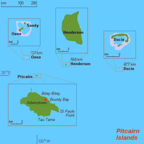
The Pitcairn Islands (; Pitkern: '), officially the Pitcairn, Henderson, Ducie and Oeno Islands, is a group of four volcanic islands in the southern Pacific Ocean that form the sole British Overseas Territory in the Pacific Ocean. The four islands—Pitcairn, Henderson, Ducie and Oeno—are scattered across several hundred miles of ocean and have a combined land area of about . Henderson Island accounts for 86% of the land area, but only Pitcairn Island is inhabited. The islands nearest to the Pitcairn Islands are Mangareva (of French Polynesia) at 688 km to the west and Easter Island at 1,929 km to the east. The Pitcairn Islanders are a biracial ethnic group descended mostly from nine ''Bounty'' mutineers and a handful of Tahitian consorts—as is still apparent from the surnames of many of the islanders. The mutiny and its aftermath have been the subject of many books and films. As of January 2020, the territory had only 47 permanent inhabitants. History Polynesi ... [...More Info...] [...Related Items...] OR: [Wikipedia] [Google] [Baidu] |
British Overseas Territories
The British Overseas Territories (BOTs), also known as the United Kingdom Overseas Territories (UKOTs), are fourteen dependent territory, territories with a constitutional and historical link with the United Kingdom. They are the last remnants of the former British Empire and do not form part of the United Kingdom itself. The permanently inhabited territories are internally Self-governance, self-governing, with the United Kingdom retaining responsibility for Defence (military), defence and foreign relations. Three of the territories are inhabited only by a transitory population of military or scientific personnel. All but one of the rest are listed by the Special Committee on Decolonization, UN Special Committee on Decolonization as United Nations list of non-self-governing territories, non-self-governing territories. All fourteen have the Monarchy of the United Kingdom, British monarch as head of state. three territories (the Falkland Islands, Gibraltar and the Akrotiri an ... [...More Info...] [...Related Items...] OR: [Wikipedia] [Google] [Baidu] |
Pacific Ocean
The Pacific Ocean is the largest and deepest of Earth's five oceanic divisions. It extends from the Arctic Ocean in the north to the Southern Ocean (or, depending on definition, to Antarctica) in the south, and is bounded by the continents of Asia and Oceania in the west and the Americas in the east. At in area (as defined with a southern Antarctic border), this largest division of the World Ocean—and, in turn, the hydrosphere—covers about 46% of Earth's water surface and about 32% of its total surface area, larger than Earth's entire land area combined .Pacific Ocean . '' Britannica Concise.'' 2008: Encyclopædia Britannica, Inc. The centers of both the |
Geography Of The Pitcairn Islands
The Pitcairn Islands consist of four islands: Pitcairn Island (a volcanic high island), Henderson Island (an uplifted coral island), and two coral atolls, Oeno Island and Ducie Island. The only inhabited island, Pitcairn, has an area of and a population density of ; it is only accessible by boat through Bounty Bay. The other islands are at a distance of more than . Location The Pitcairn Islands as a group of islands in Oceania:() * Pitcairn Island (main island) () * Henderson Island () * Ducie Island () * Oeno Island () Situated in the South Pacific Ocean, about one-half of the way from Peru to New Zealand, they are one of the most remote sites of human habitation on Earth. The only inhabited island, Pitcairn, is at 25.04 south, 130.06 west. Pitcairn is about southeast of Tahiti, from Auckland, New Zealand, and over from Panama. Area :''Total:'' :''Land:'' :''Water:'' Pitcairn Island is about long and wide. This is about of the size of Washington, DC. Land bou ... [...More Info...] [...Related Items...] OR: [Wikipedia] [Google] [Baidu] |
Landforms Of The Pitcairn Islands
A landform is a natural or anthropogenic land feature on the solid surface of the Earth or other planetary body. Landforms together make up a given terrain, and their arrangement in the landscape is known as topography. Landforms include hills, mountains, canyons, and valleys, as well as shoreline features such as bays, peninsulas, and seas, including submerged features such as mid-ocean ridges, volcanoes, and the great ocean basins. Physical characteristics Landforms are categorized by characteristic physical attributes such as elevation, slope, orientation, stratification, rock exposure and soil type. Gross physical features or landforms include intuitive elements such as berms, mounds, hills, ridges, cliffs, valleys, rivers, peninsulas, volcanoes, and numerous other structural and size-scaled (e.g. ponds vs. lakes, hills vs. mountains) elements including various kinds of inland and oceanic waterbodies and sub-surface features. Mountains, hills, plateaux, and plains are the fo ... [...More Info...] [...Related Items...] OR: [Wikipedia] [Google] [Baidu] |
Landforms Of Oceania
A landform is a natural or anthropogenic land feature on the solid surface of the Earth or other planetary body. Landforms together make up a given terrain, and their arrangement in the landscape is known as topography. Landforms include hills, mountains, canyons, and valleys, as well as shoreline features such as bays, peninsulas, and seas, including submerged features such as mid-ocean ridges, volcanoes, and the great ocean basins. Physical characteristics Landforms are categorized by characteristic physical attributes such as elevation, slope, orientation, stratification, rock exposure and soil type. Gross physical features or landforms include intuitive elements such as berms, mounds, hills, ridges, cliffs, valleys, rivers, peninsulas, volcanoes, and numerous other structural and size-scaled (e.g. ponds vs. lakes, hills vs. mountains) elements including various kinds of inland and oceanic waterbodies and sub-surface features. Mountains, hills, plateaux, and plains are the fo ... [...More Info...] [...Related Items...] OR: [Wikipedia] [Google] [Baidu] |

.jpg)

.jpg)