|
Panorama Of London
The city of London has long been a subject for panoramas by artists, mapmakers, and topographers. Many of their works have this as their title. History The earliest topographical drawings preceded maps according to modern definition, although they were mainly based on surveys or multiple drawings reduced to a (fairly) consistent perspective, as it is clearly impossible for them to have been produced from any single real viewpoint, unlike modern photographic panoramas. Wenceslaus Hollar's 1647 ''Long View of London from Bankside'' is an exception. Projected from a single viewpoint it resembles the perspective of a modern panoramic photograph. Panoramas Amongst the earliest known is that by Flemish topographer Anton van den Wyngaerde, produced in 1543 and published by London Topographical Society in 1881 with key added on bottom as reproduced here: Others include Van Visscher's of 1616: Wenceslaus Hollar's ''Long View of London from Bankside'' of 1647: Another by Hollar, 1666 ... [...More Info...] [...Related Items...] OR: [Wikipedia] [Google] [Baidu] |
London
London is the capital and largest city of England and the United Kingdom, with a population of just under 9 million. It stands on the River Thames in south-east England at the head of a estuary down to the North Sea, and has been a major settlement for two millennia. The City of London, its ancient core and financial centre, was founded by the Romans as '' Londinium'' and retains its medieval boundaries.See also: Independent city § National capitals The City of Westminster, to the west of the City of London, has for centuries hosted the national government and parliament. Since the 19th century, the name "London" has also referred to the metropolis around this core, historically split between the counties of Middlesex, Essex, Surrey, Kent, and Hertfordshire, which largely comprises Greater London, governed by the Greater London Authority.The Greater London Authority consists of the Mayor of London and the London Assembly. The London Mayor is distinguished fr ... [...More Info...] [...Related Items...] OR: [Wikipedia] [Google] [Baidu] |
Wenceslas Hollar
Wenceslaus Hollar (23 July 1607 – 25 March 1677) was a prolific and accomplished Bohemian graphic artist of the 17th century, who spent much of his life in England. He is known to German speakers as ; and to Czech speakers as . He is particularly noted for his engravings and etchings. He was born in Prague, died in London, and was buried at St Margaret's Church, Westminster. Early life After his family was ruined by the Sack of Prague in the Thirty Years' War, the young Hollar, who had been destined for the legal profession, decided to become an artist. The earliest of his works that have come down to us are dated 1625 and 1626; they are small plates, and one of them is a copy of a "Virgin and Child" by Dürer, whose influence upon Hollar's work was always great. In 1627 he was in Frankfurt where he was apprenticed to the renowned engraver Matthäus Merian. In 1630 he lived in Strasbourg, Mainz and Koblenz, where Hollar portrayed the towns, castles, and landscapes of the ... [...More Info...] [...Related Items...] OR: [Wikipedia] [Google] [Baidu] |
Panorama Photography
Panoramic photography is a technique of photography, using specialized equipment or software, that captures images with horizontally elongated fields of view. It is sometimes known as ''wide format photography''. The term has also been applied to a photograph that is cropped to a relatively wide aspect ratio, like the familiar letterbox format in wide-screen video. While there is no formal division between " wide-angle" and " panoramic" photography, "wide-angle" normally refers to a type of lens, but using this lens type does not necessarily make an image a panorama. An image made with an ultra wide-angle fisheye lens covering the normal film frame of 1:1.33 is not automatically considered to be a panorama. An image showing a field of view approximating, or greater than, that of the human eye – about 160° by 75° – may be termed panoramic. This generally means it has an aspect ratio of 2:1 or larger, the image being at least twice as wide as it is high. The resulting images ... [...More Info...] [...Related Items...] OR: [Wikipedia] [Google] [Baidu] |
Pointing Device Gesture
In computing, a pointing device gesture or mouse gesture (or simply gesture) is a way of combining pointing device or finger movements and clicks that the software recognizes as a specific computer event and responds to accordingly. They can be useful for people who have difficulties typing on a keyboard. For example, in a web browser, a user can navigate to the previously viewed page by pressing the right pointing device button, moving the pointing device briefly to the left, then releasing the button. History The first pointing device gesture, the " drag", was introduced by Apple to replace a dedicated "move" button on mice shipped with its Macintosh and Lisa computers. Dragging involves holding down a pointing device button while moving the pointing device; the software interprets this as an action distinct from separate clicking and moving behaviors. Unlike most pointing device gestures, it does not involve the tracing of any particular shape. Although the "drag" behavior ... [...More Info...] [...Related Items...] OR: [Wikipedia] [Google] [Baidu] |
Interactive Panorama
VR photography (after virtual-reality photography) is the interactive viewing of panoramic photographs, generally encompassing a 360-degree circle or a spherical view. The results is known as VR photograph (or VR photo), 360-degree photo, photo sphere, or spherical photo, as well as interactive panorama or immersive panorama. VR photography is the art of capturing or creating a complete scene as a single image, as viewed when rotating about a single central position. Normally created by stitching together a number of photographs taken in a multi-row 360-degree rotation or using an omnidirectional camera, the complete virtual reality image can also be a totally computer-generated effect, or a composite of photography and computer generated objects. The history of VR photography is human-computer interaction in which a real or imaginary environment is simulated and users interact with and manipulate that world. Capture There are several ways of capturing VR photography. Rectili ... [...More Info...] [...Related Items...] OR: [Wikipedia] [Google] [Baidu] |
Google Earth
Google Earth is a computer program that renders a 3D computer graphics, 3D representation of Earth based primarily on satellite imagery. The program maps the Earth by superimposition, superimposing satellite images, aerial photography, and geographic information system, GIS data onto a 3D globe, allowing users to see cities and landscapes from various angles. Users can explore the globe by entering addresses and coordinates, or by using a Computer keyboard, keyboard or computer mouse, mouse. The program can also be downloaded on a smartphone or Tablet computer, tablet, using a touch screen or stylus to navigate. Users may use the program to add their own data using Keyhole Markup Language and upload them through various sources, such as forums or blogs. Google Earth is able to show various kinds of images overlaid on the surface of the earth and is also a Web Map Service client. In 2019, Google has revealed that Google Earth now covers more than 97 percent of the world, and has c ... [...More Info...] [...Related Items...] OR: [Wikipedia] [Google] [Baidu] |
Google Maps
Google Maps is a web mapping platform and consumer application offered by Google. It offers satellite imagery, aerial photography, street maps, 360° interactive panoramic views of streets ( Street View), real-time traffic conditions, and route planning for traveling by foot, car, bike, air (in beta) and public transportation. , Google Maps was being used by over 1 billion people every month around the world. Google Maps began as a C++ desktop program developed by brothers Lars and Jens Rasmussen at Where 2 Technologies. In October 2004, the company was acquired by Google, which converted it into a web application. After additional acquisitions of a geospatial data visualization company and a real-time traffic analyzer, Google Maps was launched in February 2005. The service's front end utilizes JavaScript, XML, and Ajax. Google Maps offers an API that allows maps to be embedded on third-party websites, and offers a locator for businesses and other organizations in numero ... [...More Info...] [...Related Items...] OR: [Wikipedia] [Google] [Baidu] |
Google Street View
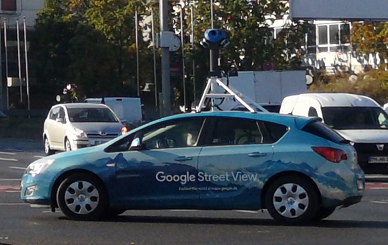
Google Street View is a technology featured in Google Maps and Google Earth that provides interactive panoramas from positions along many streets in the world. It was launched in 2007 in several cities in the United States, and has since expanded to include cities and rural areas worldwide. Streets with Street View imagery available are shown as blue lines on Google Maps. Google Street View displays interactively panoramas of stitched VR photographs. Most photography is done by car, but some is done by tricycle, camel, boat, snowmobile, underwater apparatus, and on foot. History and features Street View had its inception in 2001 with the Stanford CityBlock Project, a Google-sponsored Stanford University research project. The project ended in June 2006, and its technology was folded into StreetView. * 2007: Launched on May 25 in the United States using Immersive Media Company technology. * 2008: In May Google announces that it was testing face-blurring technology on it ... [...More Info...] [...Related Items...] OR: [Wikipedia] [Google] [Baidu] |
Tower Bridge
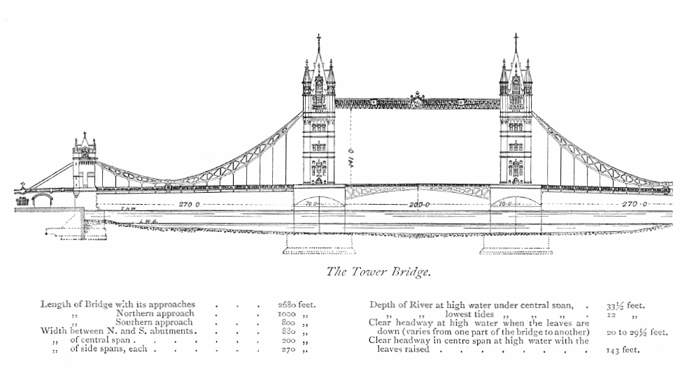
Tower Bridge is a Listed building#Grade I, Grade I listed combined Bascule bridge, bascule and Suspended-deck suspension bridge, suspension bridge in London, built between 1886 and 1894, designed by Horace Jones (architect), Horace Jones and engineered by John Wolfe Barry with the help of Henry Marc Brunel. It crosses the River Thames close to the Tower of London and is one of five London bridges owned and maintained by the Bridge House Estates, a charitable trust founded in 1282. The bridge was constructed to give better access to the East End of London, which had expanded its commercial potential in the 19th century. The bridge was opened by Edward VII, Edward, Prince of Wales and Alexandra of Denmark, Alexandra, Princess of Wales in 1894. The bridge is in length and consists of two bridge towers connected at the upper level by two horizontal walkways, and a central pair of Bascule bridge, bascules that can open to allow shipping. Originally Hydraulic power network, hydraul ... [...More Info...] [...Related Items...] OR: [Wikipedia] [Google] [Baidu] |
Monument To The Great Fire Of London
The Monument to the Great Fire of London, more commonly known simply as the Monument, is a fluted Doric column in London, England, situated near the northern end of London Bridge. Commemorating the Great Fire of London, it stands at the junction of Monument Street and Fish Street Hill, in height and 202 feet west of the spot in Pudding Lane where the Great Fire started on 2 September 1666. Constructed between 1671 and 1677, it was built on the site of St Margaret, New Fish Street, the first church to be destroyed by the Great Fire. It is Grade I-listed and is a scheduled monument. Another monument, the Golden Boy of Pye Corner, marks the point near Smithfield where the fire was stopped. The Monument comprises a Doric column built of Portland stone topped with a gilded urn of fire. It was designed by Christopher Wren and Robert Hooke. Its height marks its distance from the site of the shop of Thomas Farriner (or Farynor), the king's baker, where the blaze began. The viewi ... [...More Info...] [...Related Items...] OR: [Wikipedia] [Google] [Baidu] |
Greenwich Park
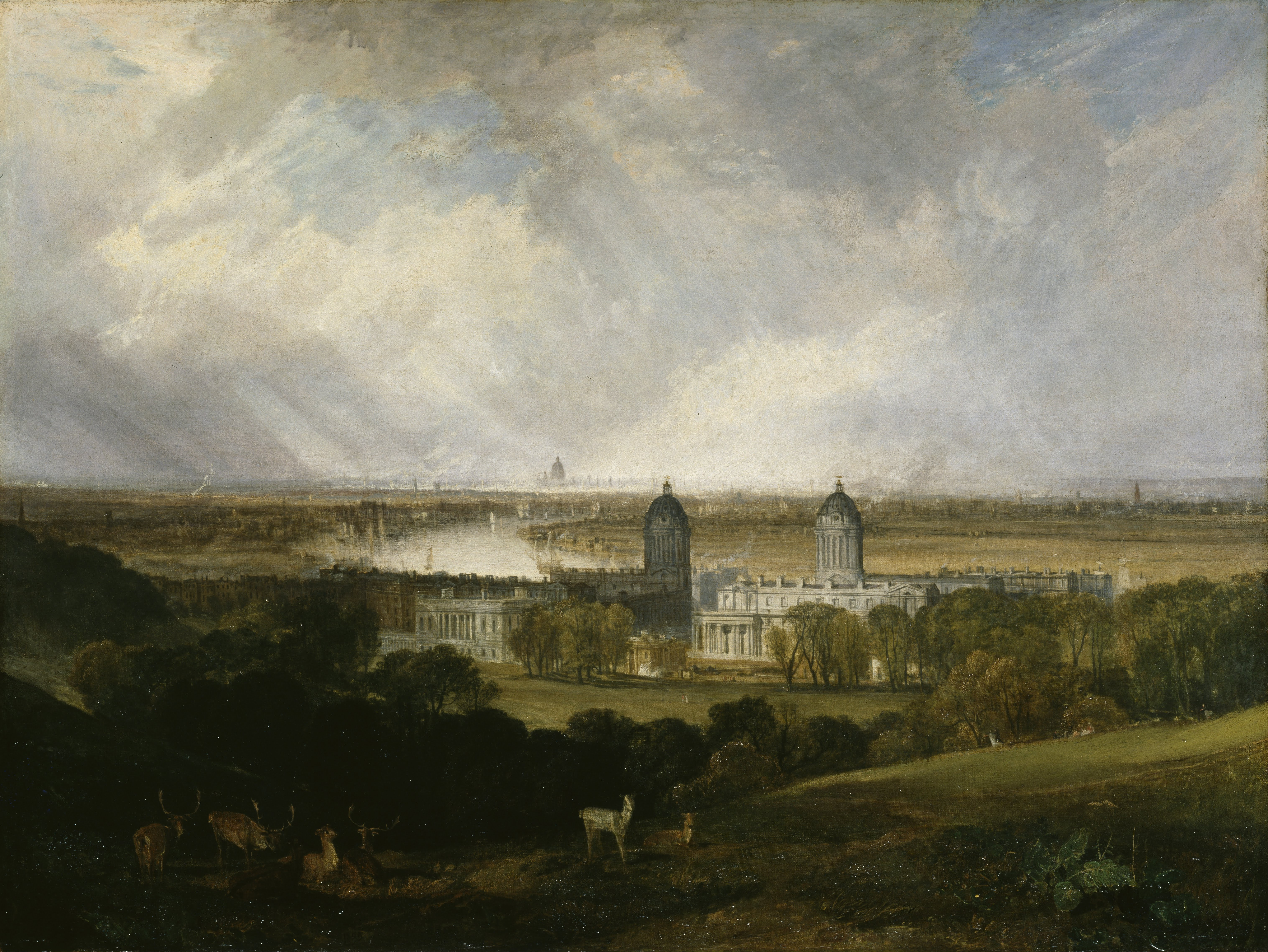
Greenwich Park is a former hunting park in Greenwich and one of the largest single green spaces in south-east London. One of the Royal Parks of London, and the first to be enclosed (in 1433), it covers , and is part of the Greenwich World Heritage Site. It commands views over the River Thames, the Isle of Dogs and the City of London (Simon Jenkins rated the view of the Royal Hospital with Canary Wharf in the distance as one of the top ten in England). The park is open year-round. It is listed Grade I on the Register of Historic Parks and Gardens. In 2020, it was awarded a National Lottery grant to restore its historic features, build a learning centre, enhance the park's biodiversity, and provide better access for people with disabilities. History The estate of some was originally owned by Saint Peter's Abbey, Ghent, but reverted to the Crown in 1427 and was given by Henry VI to his uncle Humphrey, Duke of Gloucester. He built a house by the river, Bella Court, and a sma ... [...More Info...] [...Related Items...] OR: [Wikipedia] [Google] [Baidu] |


