|
Paleo-Arctic Tradition
The Paleo-Arctic Tradition is the name given by archaeologists to the cultural tradition of the earliest well-documented human occupants of the North American Arctic, which date from the period 8000–5000 BC. The tradition covers Alaska and expands far into the east, west, and the Southwest Yukon Territory. The Upward Sun River site, a Late Pleistocene archaeological site associated with the Paleo-Arctic Tradition, located in the Tanana Valley, Alaska has now been dated to around 11,500 BP. Upward Sun River is the site of the oldest human remains discovered on the American side of Beringia. Around 8000 BC, Alaska was still connected to Siberia with the landbridge, located in the current Bering Strait. People who inhabited this region in Alaska were of the Dyuktai tradition, originally located in Siberia. Eventually, the Dyuktai changed into the Sumnagin culture, a hunting/fishing group, whose culture was defined by possessing a new technology. Other cultures flourished as we ... [...More Info...] [...Related Items...] OR: [Wikipedia] [Google] [Baidu] |
Archaeology
Archaeology or archeology is the scientific study of human activity through the recovery and analysis of material culture. The archaeological record consists of artifacts, architecture, biofacts or ecofacts, sites, and cultural landscapes. Archaeology can be considered both a social science and a branch of the humanities. It is usually considered an independent academic discipline, but may also be classified as part of anthropology (in North America – the four-field approach), history or geography. Archaeologists study human prehistory and history, from the development of the first stone tools at Lomekwi in East Africa 3.3 million years ago up until recent decades. Archaeology is distinct from palaeontology, which is the study of fossil remains. Archaeology is particularly important for learning about prehistoric societies, for which, by definition, there are no written records. Prehistory includes over 99% of the human past, from the Paleolithic until th ... [...More Info...] [...Related Items...] OR: [Wikipedia] [Google] [Baidu] |
Microblade Technology
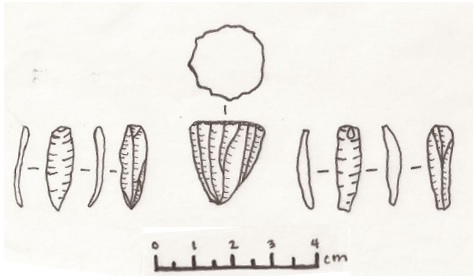
Microblade technology is a period of technological development marked by the creation and use of small stone blades, which are produced by chipping silica-rich stones like chert, quartz, or obsidian. Blades are a specialized type of lithic flake that are at least twice as long as they are wide. An alternate method of defining blades focuses on production features, including parallel lateral edges and dorsal scars, a lack of cortex, a prepared platform with a broad angle, and a proximal bulb of percussion. Microblades are generally less than 50 mm long in their finished state. History The geographic origin of microblades is poorly understood, with differing theories posing origins in Southern Siberia, Northern China, or the PHSK (Paleo-Hokkaido-Sakhalin-Kurile) peninsula, with dates ranging from over 30,000 BP to as little as 18,000 BP. Because microblade technology is economical (using less raw material than other technologies), relatively easy to make, and extremely por ... [...More Info...] [...Related Items...] OR: [Wikipedia] [Google] [Baidu] |
Archaeological Cultures Of North America
Archaeology or archeology is the scientific study of human activity through the recovery and analysis of material culture. The archaeological record consists of artifacts, architecture, biofacts or ecofacts, sites, and cultural landscapes. Archaeology can be considered both a social science and a branch of the humanities. It is usually considered an independent academic discipline, but may also be classified as part of anthropology (in North America – the four-field approach), history or geography. Archaeologists study human prehistory and history, from the development of the first stone tools at Lomekwi in East Africa 3.3 million years ago up until recent decades. Archaeology is distinct from palaeontology, which is the study of fossil remains. Archaeology is particularly important for learning about prehistoric societies, for which, by definition, there are no written records. Prehistory includes over 99% of the human past, from the Paleolithic until the advent ... [...More Info...] [...Related Items...] OR: [Wikipedia] [Google] [Baidu] |
List Of Archaeological Periods (North America)
North American archaeological periods divides the history of pre-Columbian North America into a number of named successive eras or periods, from the earliest-known human habitation through to the early Colonial period which followed the European colonization of the Americas. Stage classification One of the most enduring classifications of archaeological periods and cultures was established in Gordon Willey and Philip Phillips' 1958 book ''Method and Theory in American Archaeology.'' They divided the archaeological record in the Americas into 5 phases, only three of which applied to North America. The use of these divisions has diminished in most of North America due to the development of local classifications with more elaborate breakdowns of times. :1. The Paleo-Indians stage and/or Lithic stage :2. The Archaic stage :3. Formative stage or Post-archaic stage - At this point the North American classifications system differs from the rest of the Americas. For more details o ... [...More Info...] [...Related Items...] OR: [Wikipedia] [Google] [Baidu] |
Archaeology Of The Americas
The archaeology of the Americas is the study of the archaeology of the Western Hemisphere, including North America (Mesoamerica), Central America, South America and the Caribbean. This includes the study of pre-historic/Pre-Columbian and historic indigenous American peoples, as well as historical archaeology of more recent eras, including the Trans-Atlantic slave trade and European colonization. Chronology The Pre-Columbian era is the term generally used to encompass all time period subdivisions in the history of the Americas spanning the time from the original settlement of the Americas in the Upper Paleolithic until the European colonization of the Americas during the early modern period. While technically referring to the era before the voyages of Christopher Columbus from AD 1492 to 1504, in practice the term usually includes the history of American indigenous cultures until the 18th or 19th century. In more recent decades, archaeological scholarship has extended to includ ... [...More Info...] [...Related Items...] OR: [Wikipedia] [Google] [Baidu] |
Burin (lithic Flake)
Burin from the Upper Paleolithic (Gravettian) (ca. 29,000–22,000 BP) In the field of lithic reduction, a burin (from the French ''burin'', meaning "cold chisel" or modern engraving burin) is a type of handheld lithic flake with a chisel-like edge which prehistoric humans used for engraving or for carving wood or bone. In archaeology, burin use is often associated with "burin spalls", which are a form of debitage created when toolmakers strike a small flake obliquely from the edge of the burin flake in order to form the graving edge. Documented use left, 180px, Carinated "burin"/microblade core with multiple facets Standardized burin usage is typical of the Middle Paleolithic and Upper Palaeolithic cultures in Europe, but archaeologists have also identified them in North American cultural assemblages, and in his book ''Early Man in China'', Jia Lanpo of Beijing University lists dihedral burins and burins for truncation among artifacts uncovered along the banks of ... [...More Info...] [...Related Items...] OR: [Wikipedia] [Google] [Baidu] |
Beringia
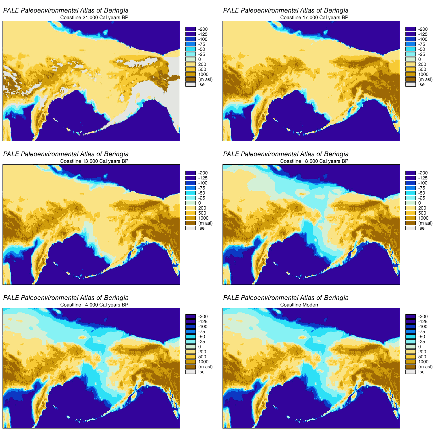
Beringia is defined today as the land and maritime area bounded on the west by the Lena River in Russia; on the east by the Mackenzie River in Canada; on the north by 72 degrees north latitude in the Chukchi Sea; and on the south by the tip of the Kamchatka Peninsula. It includes the Chukchi Sea, the Bering Sea, the Bering Strait, the Chukchi and Kamchatka Peninsulas in Russia as well as Alaska in the United States and the Yukon in Canada. The area includes land lying on the North American Plate and Siberian land east of the Chersky Range. At certain times in prehistory, it formed a land bridge that was up to wide at its greatest extent and which covered an area as large as British Columbia and Alberta together, totaling approximately . Today, the only land that is visible from the central part of the Bering land bridge are the Diomede Islands, the Pribilof Islands of St. Paul and St. George, St. Lawrence Island, St. Matthew Island, and King Island. The term ''Beringi ... [...More Info...] [...Related Items...] OR: [Wikipedia] [Google] [Baidu] |
Russia
Russia (, , ), or the Russian Federation, is a transcontinental country spanning Eastern Europe and Northern Asia. It is the largest country in the world, with its internationally recognised territory covering , and encompassing one-eighth of Earth's inhabitable landmass. Russia extends across eleven time zones and shares land boundaries with fourteen countries, more than any other country but China. It is the world's ninth-most populous country and Europe's most populous country, with a population of 146 million people. The country's capital and largest city is Moscow, the largest city entirely within Europe. Saint Petersburg is Russia's cultural centre and second-largest city. Other major urban areas include Novosibirsk, Yekaterinburg, Nizhny Novgorod, and Kazan. The East Slavs emerged as a recognisable group in Europe between the 3rd and 8th centuries CE. Kievan Rus' arose as a state in the 9th century, and in 988, it adopted Orthodox Christianity from t ... [...More Info...] [...Related Items...] OR: [Wikipedia] [Google] [Baidu] |
Kamchatka Peninsula
The Kamchatka Peninsula (russian: полуостров Камчатка, Poluostrov Kamchatka, ) is a peninsula in the Russian Far East, with an area of about . The Pacific Ocean and the Sea of Okhotsk make up the peninsula's eastern and western coastlines, respectively. Immediately offshore along the Pacific coast of the peninsula runs the Kuril–Kamchatka Trench. The Kamchatka Peninsula, the Commander Islands, and the Karaginsky Island, constitute the Kamchatka Krai of the Russian Federation. The vast majority of the 322,079 inhabitants are ethnic Russians, although about 13,000 are Koryaks (2014). More than half of the population lives in Petropavlovsk-Kamchatsky (179,526 in 2010) and nearby Yelizovo (38,980). The Kamchatka peninsula contains the volcanoes of Kamchatka, a UNESCO World Heritage Site. Geography Politically, the peninsula forms part of Kamchatka Krai. The southern tip is called Cape Lopatka. (Lopatka is Russian for spade.) The circular ... [...More Info...] [...Related Items...] OR: [Wikipedia] [Google] [Baidu] |
Before Present
Before Present (BP) years, or "years before present", is a time scale used mainly in archaeology, geology and other scientific disciplines to specify when events occurred relative to the origin of practical radiocarbon dating in the 1950s. Because the "present" time changes, standard practice is to use 1 January 1950 as the commencement date (epoch) of the age scale. The abbreviation "BP" has been interpreted retrospectively as "Before Physics", which refers to the time before nuclear weapons testing artificially altered the proportion of the carbon isotopes in the atmosphere, which scientists must now account for. In a convention that is not always observed, many sources restrict the use of BP dates to those produced with radiocarbon dating; the alternative notation RCYBP stands for the explicit "radio carbon years before present". Usage The BP scale is sometimes used for dates established by means other than radiocarbon dating, such as stratigraphy. This usage differs from ... [...More Info...] [...Related Items...] OR: [Wikipedia] [Google] [Baidu] |
Stratigraphy
Stratigraphy is a branch of geology concerned with the study of rock layers ( strata) and layering (stratification). It is primarily used in the study of sedimentary and layered volcanic rocks. Stratigraphy has three related subfields: lithostratigraphy (lithologic stratigraphy), biostratigraphy (biologic stratigraphy), and chronostratigraphy (stratigraphy by age). Historical development Catholic priest Nicholas Steno established the theoretical basis for stratigraphy when he introduced the law of superposition, the principle of original horizontality and the principle of lateral continuity in a 1669 work on the fossilization of organic remains in layers of sediment. The first practical large-scale application of stratigraphy was by William Smith in the 1790s and early 19th century. Known as the "Father of English geology", Smith recognized the significance of strata or rock layering and the importance of fossil markers for correlating strata; he created the first geologic map ... [...More Info...] [...Related Items...] OR: [Wikipedia] [Google] [Baidu] |
.jpg)


