|
Pakxan
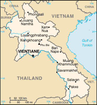
Pakxan (''Paksan'' or ''Muang Pakxan'') ( Lao ປາກຊັນ) (french: Paksane) is a district and a town in Bolikhamsai Province, in western Laos. It is the capital of Pakxan District. The Nam Xan River joins the Mekong River at Pakxan on the border with Thailand, opposite Bueng Kan. Pakxan is connected to the south of Laos by Route 13. History Pakxan was founded in the late-19th century. The Pakxan region had experienced insecurity since the invasion by Annam in 1834, followed by invasions by the Siamese, and Siamese sovereignty over Laos in 1836, and especially after 1865 with the invasions of Haws or "red flags", gangs from southern China. These invasions began to reduce the populations of Xieng Khouang and Bolikhamsai, but it was the Siamese who completed the depopulation by deporting most of the Phou Eun inhabiting the region.Jean-Louis Archet, ''Formes et résultat des activités du monde rural dans le Koueng Borikhane (Laos)'', mémoire de géographie du sous- ... [...More Info...] [...Related Items...] OR: [Wikipedia] [Google] [Baidu] |
Pakxan District
Pakxan (''Paksan'' or ''Muang Pakxan'') ( Lao ປາກຊັນ) (french: Paksane) is a district and a town in Bolikhamsai Province, in western Laos. It is the capital of Pakxan District. The Nam Xan River joins the Mekong River at Pakxan on the border with Thailand, opposite Bueng Kan. Pakxan is connected to the south of Laos by Route 13. History Pakxan was founded in the late-19th century. The Pakxan region had experienced insecurity since the invasion by Annam in 1834, followed by invasions by the Siamese, and Siamese sovereignty over Laos in 1836, and especially after 1865 with the invasions of Haws or "red flags", gangs from southern China. These invasions began to reduce the populations of Xieng Khouang and Bolikhamsai, but it was the Siamese who completed the depopulation by deporting most of the Phou Eun inhabiting the region.Jean-Louis Archet, ''Formes et résultat des activités du monde rural dans le Koueng Borikhane (Laos)'', mémoire de géographie du sous- ... [...More Info...] [...Related Items...] OR: [Wikipedia] [Google] [Baidu] |
Provinces Of Laos
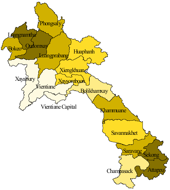
Laos, officially the ''Lao People's Democratic Republic'', is divided into 17 provinces ( Lao ແຂວງ, , , or ) and one prefecture, the Vientiane capital city municipality (ນະຄອນຫຼວງ, nakhon louang, or ''Na Kone Luang Vientiane''). The special administrative zone (ເຂດພິເສດ, ''khet phiset''), Xaisomboun, created in 1994, was dissolved on 13 January 2006. In 2013, parts of the former special administrative zone was reestablished as Xaisomboun province. Provinces and prefectures of Laos Population The population of each province in 2015 is given in the census data. History In 1989 Vientiane prefecture was split from Vientiane province and the capital of Vientiane province moved from Vientiane to Muang Phôn-Hông. In 1994 Xaisômboun khetphiset (special region) was formed from parts of the Bolikhamxai, Vientiane, and Xiangkhoang provinces. In 2006 Xaisomboun special region was dissolved and the Longsan, Xaysomboun, Phun, and Hom dist ... [...More Info...] [...Related Items...] OR: [Wikipedia] [Google] [Baidu] |
List Of Cities In Laos
This is a list of cities in Laos, a country in Asia. Towns and cities Gallery File:ตานกมอง - เวียงจันทน์.jpg, Vientiane File:Champasak Pakse8 tango7174.jpg, Pakse File:Savannakhet1.JPG, Savannakhet File:Luang Prabang pano Wikimedia Commons.jpg, Luang Prabang File:View of Thakhek and Mountains.jpg, Thakhek See also * Provinces of Laos * Districts of Laos References External links {{Asia topic, List of cities in Laos, List of cities in Cities Laos Laos (, ''Lāo'' )), officially the Lao People's Democratic Republic ( Lao: ສາທາລະນະລັດ ປະຊາທິປະໄຕ ປະຊາຊົນລາວ, French: République démocratique populaire lao), is a socialist ... simple:List of cities in Laos ... [...More Info...] [...Related Items...] OR: [Wikipedia] [Google] [Baidu] |
Districts Of Laos
Laos is divided into 17 provinces ( Lao: ແຂວງ, '' khoueng'') and 1 prefecture (''kampheng nakhon''), or capital city municipality (ນະຄອນຫລວງ, '' nakhon luang''). Furthermore, 1 so-called special administrative zone (ເຂດພິເສດ, '' khet phiset'') existed between 1994 and 2006, when it was re-merged into its surrounding provinces (i.e. Vientiane and Xiangkhoang). The Xaisomboun special administrative zone was later recreated as the 17th province. Each province is subdivided into districts ( Lao: ເມືອງ, ''mueang'') and then subdivided into villages ( Lao: ບ້ານ, ''baan''). Districts of Laos :Note — Each district has a code in parentheses displaying the first two digits as the province and the last two as the district representing that province. References External links * * Laos Ministry of Education district maps [...More Info...] [...Related Items...] OR: [Wikipedia] [Google] [Baidu] |
Nam Xan River
The Nam Xan River (french: Nam Sane) is a major river of west-central Laos. It flows from the mountains of central Laos through Borikham and joins the Mekong River at at Pakxan Pakxan (''Paksan'' or ''Muang Pakxan'') ( Lao ປາກຊັນ) (french: Paksane) is a district and a town in Bolikhamsai Province, in western Laos. It is the capital of Pakxan District. The Nam Xan River joins the Mekong River at Pakxan on .... References Rivers of Laos Geography of Bolikhamsai province {{Laos-river-stub ... [...More Info...] [...Related Items...] OR: [Wikipedia] [Google] [Baidu] |
Route 13 (Laos)
Route 13 is the most important highway in Laos. It begins at Boten in northern Laos at the Chinese border. It connects the city of Vientiane to Luang Prabang in the north and roughly follows the line of the Mekong River down to the border with Cambodia. The road then continues at National Highway 7 in Cambodia. Route 13 passes the New Laos National Stadium at Vientiane prefecture and all three international airports in Laos Vientiane Airport, Luang Prabang Airport, and Pakse Airport. Between Boten and Nateuy a 20 km segment of Route 13 is part of the Kunming-Bangkok Expressway, (Asian Highway AH3). From Nateuy to Vientiane, Route 13 is part of AH12 and from Vientiane to the border of Cambodia, AH11. It roughly parallels to Vientiane-Boten Expressway. Route 13 passes through the cities of Vientiane, Vang Vieng, Phoukhoune district where is intersection of Route 7 (Laos), and Luang Prabang. The road is mostly paved, though the pavement is in poor condition at pla ... [...More Info...] [...Related Items...] OR: [Wikipedia] [Google] [Baidu] |
Bueng Kan
Bueng Kan ( th, บึงกาฬ, ) is a town (''thesaban mueang'') in Mueang Bueng Kan district, in Bueng Kan province, far northeastern Thailand. It is the district capital and is on the Mekong River, opposite the Laotian town of Pakxan of Bolikhamsai province. It lies at the junction of Highways 212 and 222, northeast of Nong Khai and northeast of Bangkok. The economy is based on agriculture, with para rubber as the principal crop, and tourism. History The settlement became a sanitary district in 1956. Like all sanitary districts, it was upgraded to sub-district municipality in 1999. Bueng Kan was formerly part of Nong Khai Province until the formal establishment of the new province of the same name on 23 March 2011. ''Bueng'' () means marsh; ''Kan'' () is associated with the Hindu deity Kāla, or the colour black. Transport The city is connected to many major cities by day and night airconditioned express buses. The journey to Udon Thani takes around 3 hours 45 minut ... [...More Info...] [...Related Items...] OR: [Wikipedia] [Google] [Baidu] |
Lao Alphabet
Lao script or Akson Lao ( lo, ອັກສອນລາວ, links=no ) is the primary script used to write the Lao language and other minority languages in Laos. Its earlier form, the Tai Noi script, was also used to write the Isan language, but was replaced by the Thai script. It has 27 consonants ( ), 7 consonantal ligatures ( ), 33 vowels (/ ), and 4 tone marks ( ). The Lao alphabet was adapted from the Khmer script, which itself was derived from the Pallava script, a variant of the Grantha script descended from the Brāhmī script, which was used in southern India and South East Asia during the 5th and 6th centuries AD. Akson Lao is a sister system to the Thai script, with which it shares many similarities and roots. However, Lao has fewer characters and is formed in a more curvilinear fashion than Thai. Lao is written from left to right. Vowels can be written above, below, in front of, or behind consonants, with some vowel combinations written before, over, and after. Sp ... [...More Info...] [...Related Items...] OR: [Wikipedia] [Google] [Baidu] |
Time In Laos
Time in Laos is given by Indochina Time (ICT) ( UTC+07:00). Laos does not observe daylight saving time. Laos shares the same time zone with Cambodia, Thailand, Vietnam, Christmas Island, and Western Indonesia. References Laos Laos (, ''Lāo'' )), officially the Lao People's Democratic Republic ( Lao: ສາທາລະນະລັດ ປະຊາທິປະໄຕ ປະຊາຊົນລາວ, French: République démocratique populaire lao), is a socialist ... Time in Southeast Asia {{Laos-stub ... [...More Info...] [...Related Items...] OR: [Wikipedia] [Google] [Baidu] |
Mekong River
The Mekong or Mekong River is a trans-boundary river in East Asia and Southeast Asia. It is the world's twelfth longest river and the third longest in Asia. Its estimated length is , and it drains an area of , discharging of water annually. From the Tibetan Plateau the river runs through China, Myanmar, Laos, Thailand, Cambodia, and Vietnam. The extreme seasonal variations in flow and the presence of rapids and waterfalls in the Mekong make navigation difficult. Even so, the river is a major trade route between western China and Southeast Asia. Names The Mekong was originally called ''Mae Nam Khong'' from a contracted form of Tai shortened to ''Mae Khong''. In Thai and Lao, ''Mae Nam'' ("Mother of Water ) is used for large rivers and ''Khong'' is the proper name referred to as "River Khong". However, ''Khong'' is an archaic word meaning "river", loaned from Austroasiatic languages, such as Vietnamese ''sông'' (from *''krong'') and Mon ''kruŋ'' "river", which led to Chin ... [...More Info...] [...Related Items...] OR: [Wikipedia] [Google] [Baidu] |
Thailand
Thailand ( ), historically known as Siam () and officially the Kingdom of Thailand, is a country in Southeast Asia, located at the centre of the Indochinese Peninsula, spanning , with a population of almost 70 million. The country is bordered to the north by Myanmar and Laos, to the east by Laos and Cambodia, to the south by the Gulf of Thailand and Malaysia, and to the west by the Andaman Sea and the extremity of Myanmar. Thailand also shares maritime borders with Vietnam to the southeast, and Indonesia and India to the southwest. Bangkok is the nation's capital and largest city. Tai peoples migrated from southwestern China to mainland Southeast Asia from the 11th century. Indianised kingdoms such as the Mon, Khmer Empire and Malay states ruled the region, competing with Thai states such as the Kingdoms of Ngoenyang, Sukhothai, Lan Na and Ayutthaya, which also rivalled each other. European contact began in 1511 with a Portuguese diplomatic mission to Ayutthaya, w ... [...More Info...] [...Related Items...] OR: [Wikipedia] [Google] [Baidu] |


