|
Place Code
A P-code, short for place code, is a kind of geocode A geocode is a code that represents a geographic entity (location or Geographical feature, object). It is a unique identifier of the entity, to distinguish it from others in a finite set of geographic entities. In general the ''geocode'' is a ... used mostly by emergency response teams. It provides unique identifiers to thousands of locations and administrative units in a humanitarian operation. The p-codes are represented by combinations of letters and/or numbers to identify a specific location or feature on a map or within a database. These codes provide a systematic means of linking data to an unambiguous location. Any information that is tagged with P-codes can be combined and analyzed with any other p-coded data. The p-codes for a country can be found in the Common Operational Datasets, which are standard geographic references for the humanitarian community provided bUN OCHA ReferencesP-code Flyer [...More Info...] [...Related Items...] OR: [Wikipedia] [Google] [Baidu] |
Geocode
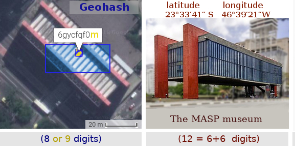
A geocode is a code that represents a geographic entity (location or Geographical feature, object). It is a unique identifier of the entity, to distinguish it from others in a finite set of geographic entities. In general the ''geocode'' is a human-readable and short identifier. Typical geocodes (in bold) and entities represented by it: * ''Country code'' and subdivision code. Polygon of the administrative boundaries of a country or a subdivision. The main examples are ISO codes: ISO 3166-1 alpha-2 code (e.g. AF for Afghanistan or BR for Brazil), and its subdivision conventions, such as ISO 3166-2:AF, subdivision codes (e.g. AF-GHO for Ghor province) or ISO 3166-2:BR, subdivision codes (e.g. BR-AM for Amazonas (Brazilian state), Amazonas state). * ''DGG cell ID''. Identifier of a cell of a discrete global grid: a Geohash code (e.g. ~0.023km2 cell 6vd23gq at Brazil's Geographical centre, centroid) or a Open Location Code, Plus Code (e.g. ~0.0002km2 cell 58Q8XXXX+XX with ... [...More Info...] [...Related Items...] OR: [Wikipedia] [Google] [Baidu] |
