|
Parkachik Glacier
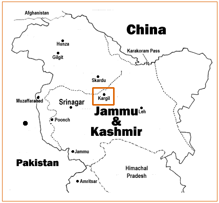
Parachik Glacier is a mountain glacier in Kargil, Ladakh, India. Parkachik Glacier, located at Parkachik, is a mass of ice moving slowly down the Nun-Kun slopes. This ice mass falls finally into the Suru River, providing views of the huge ice-fall. Great slabs of ice periodically peel off the glacier's 300-foot high front wall. A suspension footbridge over the Suru River is there for the visitors to walk up to the glacier. Some mountaineers use this glacier to approach the difficult north face route to scale Mt Nun. Camping areas are offered in the upper Suru Valley. Panikhar is a nearby place of attraction. Parkachik can be approached from Kargil Kargil ( lbj, ) is a city and a joint capital of the union territory of Ladakh, India. It is also the headquarters of the Kargil district. It is the second-largest city in Ladakh after Leh. Kargil is located to the east of Srinagar in Ja ..., which is 90 km north. References Geography of Ladakh Kargil dis ... [...More Info...] [...Related Items...] OR: [Wikipedia] [Google] [Baidu] |
Ladakh
Ladakh () is a region administered by India as a union territory which constitutes a part of the larger Kashmir region and has been the subject of dispute between India, Pakistan, and China since 1947. (subscription required) Quote: "Jammu and Kashmir, state of India, located in the northern part of the Indian subcontinent in the vicinity of the Karakoram and westernmost Himalayan mountain ranges. From 1947 to 2019, Ladakh was part of the Indian state of Jammu and Kashmir, which has been the subject of dispute between India, Pakistan, and China since the partition of the subcontinent in 1947." Quote: "Jammu and Kashmir: Territory in northwestern India, subject to a dispute between India and Pakistan. It has borders with Pakistan and China." Ladakh is bordered by the Tibet Autonomous Region to the east, the Indian state of Himachal Pradesh to the south, both the Indian-administered union territory of Jammu and Kashmir (union territory), Jammu and Kashmir and the Pakistan-administ ... [...More Info...] [...Related Items...] OR: [Wikipedia] [Google] [Baidu] |
India
India, officially the Republic of India (Hindi: ), is a country in South Asia. It is the seventh-largest country by area, the second-most populous country, and the most populous democracy in the world. Bounded by the Indian Ocean on the south, the Arabian Sea on the southwest, and the Bay of Bengal on the southeast, it shares land borders with Pakistan to the west; China, Nepal, and Bhutan to the north; and Bangladesh and Myanmar to the east. In the Indian Ocean, India is in the vicinity of Sri Lanka and the Maldives; its Andaman and Nicobar Islands share a maritime border with Thailand, Myanmar, and Indonesia. Modern humans arrived on the Indian subcontinent from Africa no later than 55,000 years ago., "Y-Chromosome and Mt-DNA data support the colonization of South Asia by modern humans originating in Africa. ... Coalescence dates for most non-European populations average to between 73–55 ka.", "Modern human beings—''Homo sapiens''—originated in Africa. Then, int ... [...More Info...] [...Related Items...] OR: [Wikipedia] [Google] [Baidu] |
Nun-Kun
Nun Kun is a mountain massif of the greater Himalayan range, located on the border of Jammu and Kashmir and Ladakh in northern India. It consists of two main peaks: Nun () and Kun (),Figures for Kun's elevation vary between 7,035 m and 7,086 m. separated from each other by a 4 km long snowy plateau, with a third peak of the massif, known as Pinnacle Peak (), lying at its eastern end. Nun is the tallest peak of Jammu and Kashmir, while its sister peak Kun lies in Ladakh. It is about 250 km (160 mi) east of Srinagar. The Nun Kun massif is bounded to the north by the Suru valley and the Zanskar range, flanked to the east by the Pensi La (4400 m), which separates the Suru and Zanskar Valleys, while the Kishtwar National Park and the Krash Nai river lie to its south. The rocks predominantly are stratified sedimentary rocks composed of shale and sandstone. Metamorphic rocks and granite formations are also seen at places. The area is rich in minerals, especi ... [...More Info...] [...Related Items...] OR: [Wikipedia] [Google] [Baidu] |
Suru River (Indus)
The Suru River is a tributary of the Indus River that flows largely through the Kargil district of Ladakh, India. The Suru Valley is coextensive with the Kargil tehsil, with the town of Kargil situated on its banks. The river enters the Skardu District of Pakistani-administered Gilgit-Baltistan, coursing a brief length before joining the Indus at Nurla. Geography The Suru River is a long river, that originates from the Panzella glacier which lies at Pensi La pass near the Drang Drung Glacier. The Drang Drung Glacier also gives rise to the Stod River which flows down in the opposite direction from the Suru. The source of the Suru River lies south of Kargil town, and north from Zanskar. Srinagar, the capital of Jammu and Kashmir lies to the west. The Suru River forms the western and northern boundary of the Zanskar Range. The river flows westwards, along with the Kargil-Zanaskar Road, from its source and forms the Suru valley, which is towered by the massif of Nun Ku ... [...More Info...] [...Related Items...] OR: [Wikipedia] [Google] [Baidu] |
Kargil
Kargil ( lbj, ) is a city and a joint capital of the union territory of Ladakh, India. It is also the headquarters of the Kargil district. It is the second-largest city in Ladakh after Leh. Kargil is located to the east of Srinagar in Jammu and Kashmir, and to the west of Leh. It is the centre point of the Suru River. Etymology The name ''Kargil'' is said to derive from the words ''Khar'', meaning castle, and ''rKil'' meaning "centre". "Kargil denotes a place between many forts, a central place where people could stay". It appears to be a fitting description for a place that is equidistant from Srinagar, Leh and Skardu Historically, the region around Kargil was called Purig. A major study of the history of Purig is included in the 1987 book ''Qadeem Ladakh'' by Kacho Sikander Khan, which includes genealogies of various dynasties that ruled the region. History Kargil is the main town in the historical region of Purig, which consists of the Suru river basin. It was n ... [...More Info...] [...Related Items...] OR: [Wikipedia] [Google] [Baidu] |
Geography Of Ladakh
Ladakh is an administrative territory of India that has been under its control since 1947. The geographical region of Ladakh union territory is the highest altitude plateau region in India (much of it being over 3,000 m), incorporating parts of the Himalayan and Karakoram mountain ranges and the upper Indus River and valley. Political geography Historic Ladakh consists of a number of distinct areas (mainly under Indian rule), including the fairly populous main Indus valley, the more remote Zanskar (in the south) and Nubra valleys (to the north over Khardung La in the Ladakh mountain range, a high motorable pass at ), the almost deserted Aksai Chin (under Chinese rule) and the predominantly Shi'ite Muslim Kargil and Suru valley areas in the west (Kargil being the second most important town in Ladakh). Historically populated by the Ladakhi people, continued immigration and preferential treatment to Kashmiris by the J&K government have led to demographic changes in the ... [...More Info...] [...Related Items...] OR: [Wikipedia] [Google] [Baidu] |


