|
Otmoor
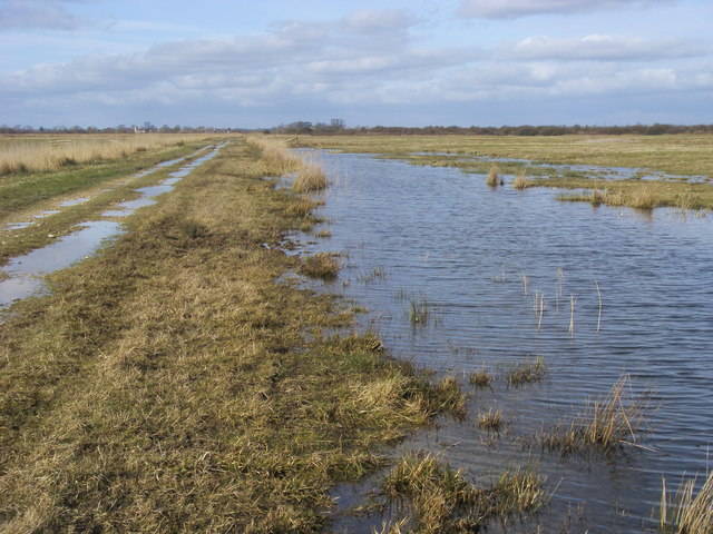
Otmoor or Ot Moor is an area of wetland and wet grassland in Oxfordshire, England, located halfway between Oxford and Bicester. It is about above sea level, and has an area of nearly . It is encircled by the "Seven Towns" of Otmoor: Beckley, Oxfordshire, Beckley, Noke, Oxfordshire, Noke, Oddington, Oxfordshire, Oddington, Charlton-on-Otmoor, Fencott, Murcott, Oxfordshire, Murcott and Horton-cum-Studley. Part of it is a nature reserve, RSPB Otmoor, which adjoins a Ministry of Defence firing range, which is part of a Site of Special Scientific Interest. History Bisected north–south by the Roman Road between Alchester Roman Town, Alchester and Dorchester-on-Thames, its name is derived from the Old English for "Otta's Fen". Enclosure Watered by the River Ray, it was until the early 19th century unenclosed marshland, and regularly flooded in winter. An Enclosure Act was passed in 1815, under which the area was extensively drained. This disadvantaged the local farmers and led to ci ... [...More Info...] [...Related Items...] OR: [Wikipedia] [Google] [Baidu] |
Charlton-on-Otmoor
Charlton-on-Otmoor is a village and civil parish about NE of Oxford and SW of Bicester in Oxfordshire, England. The village, one of the seven "towns" of Otmoor, is on the northern edge of the moor on a ridge of Cornbrash. The 2011 Census recorded the parish's population as 449. Toponym The Domesday Book of 1086 records the place-name as ''Cerlentone''. The chronicler Orderic Vitalis recorded that in 1081 it was spelt ''Cherlentona'' or ''Charlentone''. In about 1190 a charter of Thame Abbey recorded it as ''Cherlenton'' and a charter of Sandford Preceptory recorded it as ''Cherleton''. A Close Roll from 1245 records the name as ''Cherlton''. The Hundred Rolls of 1278–79 record it as ''Cherleton' super Ottemor''. Assize rolls from 1285 variously record it as ''Cherlintone'', ''Cheriltone'', ''Chereltone'' and ''Chureltone''. An entry in the Calendar of Inquisitions Post Mortem for 1314 records it as ''Cherleton upon Ottemour'' and a Close Roll from 1315 records it as '' ... [...More Info...] [...Related Items...] OR: [Wikipedia] [Google] [Baidu] |
RSPB Otmoor
Otmoor RSPB Reserve is a nature reserve, managed by the RSPB, between Beckley and Oddington, within the wider area of Otmoor, in Oxfordshire, England. The reserve was established in 1997 and restored large areas of marshland from what had previously been farmland. The RSPB reserve covers around . Otmoor is primarily wetland and in winter provides a home to thousands of waterfowl. It is increasingly becoming a wintering ground for thousands of wildfowl and waders. Over a thousand wigeon and teal have been recorded, while birds of prey such as merlins and peregrines are regularly seen. Large areas of Otmoor have benefited from extensive agriculture using traditional methods, resulting in good numbers of songbirds that are otherwise declining in the UK, including bullfinch, skylark, reed bunting, grasshopper warbler and European turtle dove. Spring and autumn both produce good numbers of passage migrants, including waders in the spring and common redstarts and whinchats in th ... [...More Info...] [...Related Items...] OR: [Wikipedia] [Google] [Baidu] |
Otmoor Riots
Otmoor or Ot Moor is an area of wetland and wet grassland in Oxfordshire, England, located halfway between Oxford and Bicester. It is about above sea level, and has an area of nearly . It is encircled by the "Seven Towns" of Otmoor: Beckley, Noke, Oddington, Charlton-on-Otmoor, Fencott Fencott is a Hamlet (place), hamlet between the River Ray and Otmoor in the Civil parishes in England, civil parish of Fencott and Murcott, about south of Bicester in Oxfordshire, England. History In 1542 the Crown granted most of the land at ..., Murcott, Oxfordshire, Murcott and Horton-cum-Studley. Part of it is a nature reserve, RSPB Otmoor, which adjoins a Ministry of Defence firing range, which is part of a Site of Special Scientific Interest. History Bisected north–south by the Roman Road between Alchester Roman Town, Alchester and Dorchester-on-Thames, its name is derived from the Old English for "Otta's Fen". Enclosure Watered by the River Ray, it was until the early 19th cent ... [...More Info...] [...Related Items...] OR: [Wikipedia] [Google] [Baidu] |
