|
Orcadian Basin
The Orcadian Basin is a sedimentary basin of Devonian age that formed mainly as a result of extensional tectonics in northeastern Scotland after the end of the Caledonian orogeny. During part of its history, the basin was filled by a lake now known as ''Lake Orcadie''. In that lacustrine environment, a sequence of finely bedded sedimentary rocks was deposited, containing well-preserved fish fossils, with alternating layers of mudstone and coarse siltstone to very fine sandstone. These flagstones split easily along the bedding and have been used as building material for thousands of years. The deposits of the Orcadian Basin form part of the Old Red Sandstone (ORS). The lithostratigraphic terms lower, middle and upper ORS, however, do not necessarily match exactly with sediments of lower, middle and upper Devonian age, as the base of the ORS is now known to be in the Silurian and the top in the Carboniferous. Extent The exact extent of the Orcadian Basin is uncertain due to later tecto ... [...More Info...] [...Related Items...] OR: [Wikipedia] [Google] [Baidu] |
Sedimentary Basin
Sedimentary basins are region-scale depressions of the Earth's crust where subsidence has occurred and a thick sequence of sediments have accumulated to form a large three-dimensional body of sedimentary rock. They form when long-term subsidence creates a regional depression that provides Accommodation (geology), accommodation space for accumulation of sediments. Over millions or tens or hundreds of millions of years the deposition of sediment, primarily gravity-driven transportation of water-borne eroded material, acts to fill the depression. As the sediments are buried, they are subject to increasing pressure and begin the processes of compaction (geology), compaction and lithification that transform them into sedimentary rock. Sedimentary basins are created by deformation of Earth's lithosphere in diverse geological settings, usually as a result of plate tectonics, plate tectonic activity. Mechanisms of crustal deformation that lead to subsidence and sedimentary basin formati ... [...More Info...] [...Related Items...] OR: [Wikipedia] [Google] [Baidu] |
Half-graben
A half-graben is a geological structure bounded by a fault along one side of its boundaries, unlike a full graben where a depressed block of land is bordered by parallel faults. Rift and fault structure A rift is a region where the lithosphere extends as two parts of the Earth's crust pull apart. Often a rift will form in an area of the crust that is already weakened by earlier geological activity. Extensional faults form parallel to the axis of the rift. An extensional fault may be seen as a crack in the crust that extends down at an angle to the vertical. As the two sides pull apart, the hanging wall ("hanging over" the sloping fault) will move downward relative to the footwall. The crust thins and sinks, forming a rift basin. Warm mantle material wells up, melting the crust and often causing volcanoes to emerge in the rift basin. Extensional basins may appear to be caused by a graben, or depressed block of land, sinking between parallel normal faults that dip towards th ... [...More Info...] [...Related Items...] OR: [Wikipedia] [Google] [Baidu] |
Conglomerate (geology)
Conglomerate () is a clastic sedimentary rock that is composed of a substantial fraction of rounded to subangular gravel-size clasts. A conglomerate typically contains a matrix of finer-grained sediments, such as sand, silt, or clay, which fills the interstices between the clasts. The clasts and matrix are typically cemented by calcium carbonate, iron oxide, silica, or hardened clay. Conglomerates form by the consolidation and lithification of gravel. They can be found in sedimentary rock sequences of all ages but probably make up less than 1 percent by weight of all sedimentary rocks. In terms of origin and depositional mechanisms, they are closely related to sandstones and exhibit many of the same types of sedimentary structures, e.g., tabular and trough cross-bedding and graded bedding.Boggs, S. (2006) ''Principles of Sedimentology and Stratigraphy.'', 2nd ed. Prentice Hall, New York. 662 pp. Friedman, G.M. (2003) ''Classification of sediments and sedimentary rocks.'' In G ... [...More Info...] [...Related Items...] OR: [Wikipedia] [Google] [Baidu] |
Graben
In geology, a graben () is a depressed block of the crust of a planet or moon, bordered by parallel normal faults. Etymology ''Graben'' is a loan word from German, meaning 'ditch' or 'trench'. The word was first used in the geologic context by Eduard Suess in 1883. The plural form is either ''graben'' or ''grabens''. Formation A graben is a valley with a distinct escarpment on each side caused by the displacement of a block of land downward. Graben often occur side by side with horsts. Horst and graben structures indicate tensional forces and crustal stretching. Graben are produced from parallel normal faults, where the displacement of the hanging wall is downward, while that of the footwall is upward. The faults typically dip toward the center of the graben from both sides. Horsts are parallel blocks that remain between graben; the bounding faults of a horst typically dip away from the center line of the horst. Single or multiple graben can produce a rift valley. Half-g ... [...More Info...] [...Related Items...] OR: [Wikipedia] [Google] [Baidu] |
Easter Ross
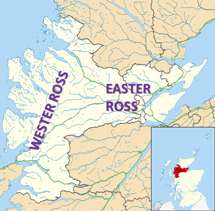
Easter Ross ( gd, Ros an Ear) is a loosely defined area in the east of Ross, Highland, Scotland. The name is used in the constituency name Caithness, Sutherland and Easter Ross, which is the name of both a British House of Commons constituency and a Scottish Parliament constituency. The two constituencies have however different boundaries. Settlements Places in Easter Ross include: * Alness * Dingwall (included in some contexts in the term ''Easter Ross'', though in some contexts it refers to the area to the north-east of Dingwall) * Evanton * Invergordon * Kildary * Milntown of Tarbat (Milton) * Portmahomack * The Seaboard villages: ** Balintore ** Hilton of Cadboll ** Shandwick * Tain Easter Ross is well known for Black Isle and its towns: Avoch, Rosemarkie, Fortrose, and Cromarty. See also * Black Isle * Ross and Cromarty * Ross-shire * Wester Ross Wester Ross () is an area of the Northwest Highlands of Scotland in the council area of Highland. The area is loosel ... [...More Info...] [...Related Items...] OR: [Wikipedia] [Google] [Baidu] |
Moine Supergroup
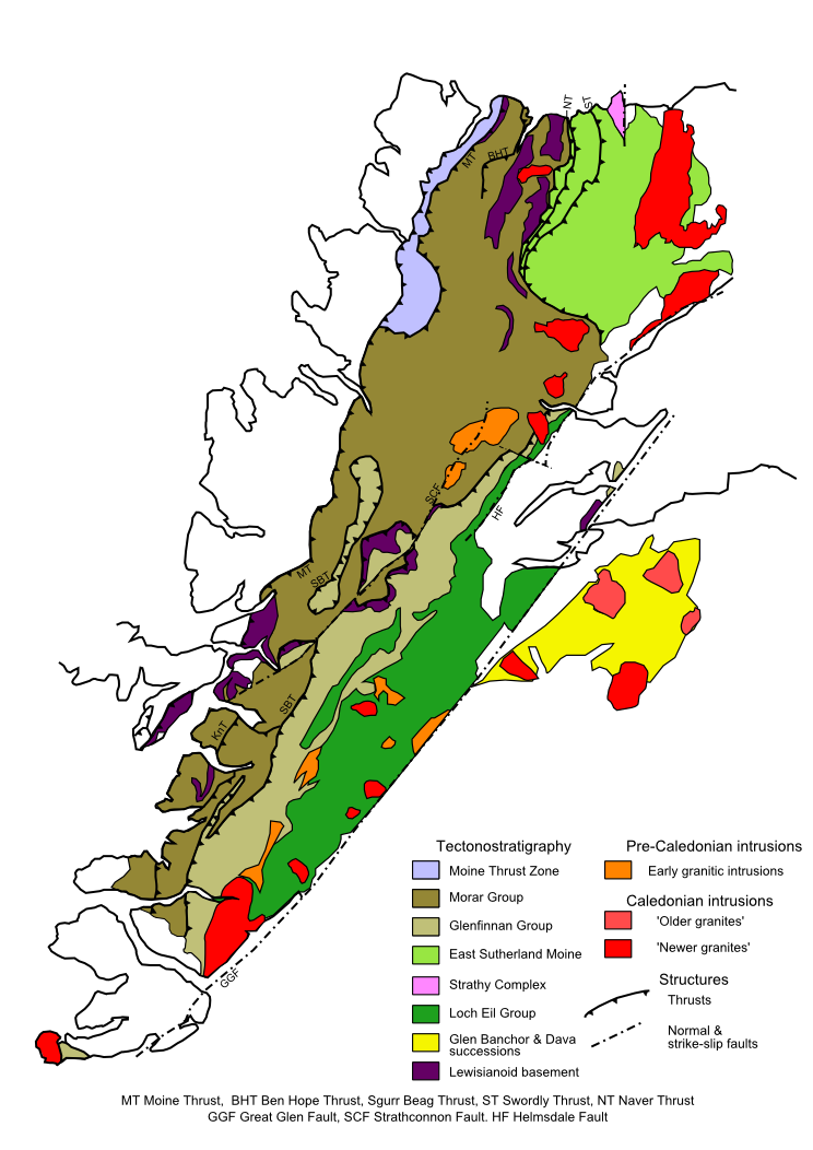
The Moine Supergroup is a sequence of Neoproterozoic metamorphic rocks that form the dominant outcrop of the Scottish Highlands between the Moine Thrust Belt to the northwest and the Great Glen Fault to the southeast. The sequence is metasedimentary in nature and was metamorphosed and deformed in a series of tectonic events during the Late Proterozoic and Early Paleozoic. It takes its name from ''A' Mhòine'', a peat bog in northern Sutherland. Distribution The main outcrop of the Moine series lies northwest of the Great Glen Fault, structurally above the Moine Thrust to the west forming what is known as the Northern Highlands Terrane. A smaller area of similar rocks that are correlated with these, outcrop within the 'Grampian Terrane' to the southeast of the Great Glen. Moinian rocks are also recognised on Mull, Orkney and Shetland. Stratigraphy The Moine Supergroup has been subdivided into different groups or divisions. The relationship between individual groups in terms of ag ... [...More Info...] [...Related Items...] OR: [Wikipedia] [Google] [Baidu] |
Granite
Granite () is a coarse-grained (phaneritic) intrusive igneous rock composed mostly of quartz, alkali feldspar, and plagioclase. It forms from magma with a high content of silica and alkali metal oxides that slowly cools and solidifies underground. It is common in the continental crust of Earth, where it is found in igneous intrusions. These range in size from dikes only a few centimeters across to batholiths exposed over hundreds of square kilometers. Granite is typical of a larger family of ''granitic rocks'', or ''granitoids'', that are composed mostly of coarse-grained quartz and feldspars in varying proportions. These rocks are classified by the relative percentages of quartz, alkali feldspar, and plagioclase (the QAPF classification), with true granite representing granitic rocks rich in quartz and alkali feldspar. Most granitic rocks also contain mica or amphibole minerals, though a few (known as leucogranites) contain almost no dark minerals. Granite is nearly alway ... [...More Info...] [...Related Items...] OR: [Wikipedia] [Google] [Baidu] |
Facies
In geology, a facies ( , ; same pronunciation and spelling in the plural) is a body of rock with specified characteristics, which can be any observable attribute of rocks (such as their overall appearance, composition, or condition of formation), and the changes that may occur in those attributes over a geographic area. A facies encompasses all of the characteristics of a rock including its chemical, physical, and biological features that distinguish it from adjacent rock. The term facies was introduced by the Swiss geologist Amanz Gressly in 1838 and was part of his significant contribution to the foundations of modern stratigraphy, which replaced the earlier notions of Neptunism. Types of facies Sedimentary facies Ideally, a Sedimentary structures, sedimentary facies is a distinctive rock unit that forms under certain conditions of sedimentation, reflecting a particular process or environment. Sedimentary facies are either descriptive or interpretative. Sedimentary facies ... [...More Info...] [...Related Items...] OR: [Wikipedia] [Google] [Baidu] |
Great Glen Fault
The Great Glen Fault is a strike-slip fault that runs through the Great Glen in Scotland. The fault is mostly inactive today, but occasional moderate tremors have been recorded over the past 150 years. Location Aligned northeast to southwest, the Great Glen Fault extends further southwest in a straight line through Loch Linnhe and the Firth of Lorne, and then on into northwestern Ireland, directly through Lough Swilly, Donegal Bay and Clew Bay as the Leannan Fault. To the northeast the fault connects to the Walls Boundary Fault and the associated Melby Fault and Nestings Fault, before becoming obscured by the effects of Mesozoic rifting to the north of Shetland. The fault continues on the North American side of the North Atlantic Ocean, but is no longer part of a contiguous fault, as the complete fault was broken when the Mid-Atlantic Ridge formed 200 million years ago. The North American side of the fault runs through the length of northwestern Newfoundland, Canada, as the C ... [...More Info...] [...Related Items...] OR: [Wikipedia] [Google] [Baidu] |
Cliffs NW Of St John's Head - Geograph
In geography and geology, a cliff is an area of rock which has a general angle defined by the vertical, or nearly vertical. Cliffs are formed by the processes of weathering and erosion, with the effect of gravity. Cliffs are common on coasts, in mountainous areas, escarpments and along rivers. Cliffs are usually composed of rock that is resistant to weathering and erosion. The sedimentary rocks that are most likely to form cliffs include sandstone, limestone, chalk, and dolomite. Igneous rocks such as granite and basalt also often form cliffs. An escarpment (or scarp) is a type of cliff formed by the movement of a geologic fault, a landslide, or sometimes by rock slides or falling rocks which change the differential erosion of the rock layers. Most cliffs have some form of scree slope at their base. In arid areas or under high cliffs, they are generally exposed jumbles of fallen rock. In areas of higher moisture, a soil slope may obscure the talus. Many cliffs also featur ... [...More Info...] [...Related Items...] OR: [Wikipedia] [Google] [Baidu] |
Sandwick Fish Bed
The Sandwick Fish Beds is a geologic formation in Scotland. It preserves fossils dating back to the Devonian period. See also * List of fossiliferous stratigraphic units in Scotland See also *Lists of fossiliferous stratigraphic units in Europe *Lists of fossiliferous stratigraphic units in the United Kingdom References * {{DEFAULTSORT:Fossiliferous stratigraphic units in Scotland Scotland Scotland (, ) is a c ... References * Geologic formations of Scotland Devonian System of Europe Devonian Scotland {{Scotland-stub ... [...More Info...] [...Related Items...] OR: [Wikipedia] [Google] [Baidu] |


